Showing 36 items matching "bundoora - maps"
-
 Greensborough Historical Society
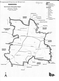
Map - Map (Copy), Electoral Boundaries Commission, Proposed electoral district: Bundoora, 01/07/2021
... ...bundoora - maps...Greensborough Historical Society 34A Glenauburn Road Lower Plenty Lower Plenty melbourne Proposed revised electoral boundaries for the electoral district of Bundoora (North-Eastern Metropolitan Region) as at 01/07/2021 electoral boundaries bundoora - maps victoria - parliament 1p. black and white copy of map Proposed electoral district: Bundoora Map Map (Copy) Electoral Boundaries Commission ...Proposed revised electoral boundaries for the electoral district of Bundoora (North-Eastern Metropolitan Region) as at 01/07/20211p. black and white copy of mapelectoral boundaries, bundoora - maps, victoria - parliament -
 Greensborough Historical Society
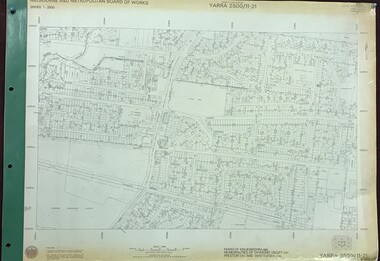
Map, Melbourne and Metropolitan Board of Works. Survey Division, MMBW, Yarra 2500 / 11.21. Bundoora, east of Plenty Road, 1979_01
... ...bundoora - maps...Yarra 2500 [base map] 11-21. Bundoora, east of Plenty Road. Parish of Keelbundoora 2856, Municipalities of Diamond Valley 257, Preston 225 and Whittlesea 239. ...Includes Yulong Park. mmbw melbourne and metropolitan board of works shire of diamond valley bundoora - maps MMBW Map in 1:2500 [scale] series. ...Melbourne and Metropolitan Board of Works. Yarra 2500 [base map] 11-21. Bundoora, east of Plenty Road. Parish of Keelbundoora 2856, Municipalities of Diamond Valley 257, Preston 225 and Whittlesea 239. Prominent streets include: Grimshaw Street, Settlement Road and Plenty Road. Includes Yulong Park.MMBW Map in 1:2500 [scale] series. Cream parchment with green tape reinforcing on edges and punched holes on left edge.mmbw, melbourne and metropolitan board of works, shire of diamond valley, bundoora - maps -
 Greensborough Historical Society
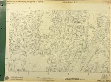
Map, Melbourne and Metropolitan Board of Works. Survey Division, MMBW, Yarra 2500 / 12.21. Watsonia North, 1979_02
... ...bundoora - maps...Includes former Institute of Social Welfare (now Loyola College) Lines Reserve and Binnak Park. mmbw melbourne and metropolitan board of works shire of diamond valley watsonia - maps bundoora - maps MMBW Map in 1:2500 [scale] series. ...Melbourne and Metropolitan Board of Works. Yarra 2500 [base map]. 12-22, Parish of Keelbundora 2856, Municipality of Diamond Valley 257. Shows street names, easement sizes, lot numbers, lodged plan numbers, names of prominent features, contour values, creek or river names. Watsonia Railway Station and environs. Prominent streets: Grimshaw Street, William Street and Macorna Street. Includes former Institute of Social Welfare (now Loyola College) Lines Reserve and Binnak Park.MMBW Map in 1:2500 [scale] series. Cream parchment with green tape reinforcing on edges and punched holes on left edge.mmbw, melbourne and metropolitan board of works, shire of diamond valley, watsonia - maps, bundoora - maps -
 Greensborough Historical Society
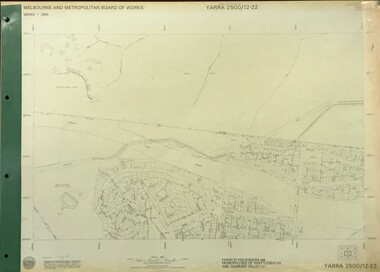
Map, Melbourne and Metropolitan Board of Works. Survey Division, MMBW, Yarra 2500 / 12.22. Watsonia North, 1978_03
... ...bundoora - maps...Includes Christian Brothers Edmund Rice College and Janefield Special School sites and "proposed future freeway" (now Metropolitan Ring Road). mmbw melbourne and metropolitan board of works shire of diamond valley watsonia - maps bundoora - maps MMBW Map in 1:2500 [scale] series. ...Melbourne and Metropolitan Board of Works. Yarra 2500 [base map]. 12-22, Parishes of Keelbundora 2856, Municipalities of Whittlesea 239 and Diamond Valley 257. Shows street names, easement sizes, lot numbers, lodged plan numbers, names of prominent features, contour values, creek or river names. Watsonia Railway Station and environs. Prominent streets: Edmund Rice Parade and Macorna Street. Includes Christian Brothers Edmund Rice College and Janefield Special School sites and "proposed future freeway" (now Metropolitan Ring Road).MMBW Map in 1:2500 [scale] series. Cream parchment with green tape reinforcing on edges and punched holes on left edge.mmbw, melbourne and metropolitan board of works, shire of diamond valley, watsonia - maps, bundoora - maps -
 Greensborough Historical Society
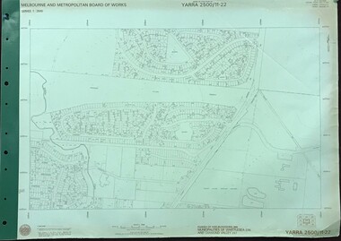
Map, Melbourne and Metropolitan Board of Works. Survey Division, MMBW, Yarra 2500 / 11.22. Bundoora, 1979_01
... ...bundoora - maps...Yarra 2500 [base map] 11-22. Bundoora. Parish of Keelbundoora 2856, Municipalities of Diamond Valley 257 and Whittlesea 239. ...MMBW, Yarra 2500 / 11.22. Bundoora. Map Map Melbourne and Metropolitan Board of Works. ...Melbourne and Metropolitan Board of Works. Yarra 2500 [base map] 11-22. Bundoora. Parish of Keelbundoora 2856, Municipalities of Diamond Valley 257 and Whittlesea 239. Prominent streets include: Greenhills Road, Cabernet Crescent and Plenty Road. Includes Parade College (Christian Brothers) and "proposed future freeway" (now Metropolitan Ring Road)MMBW Map in 1:2500 [scale] series. Cream parchment with green tape reinforcing on edges and punched holes on left edge.mmbw, melbourne and metropolitan board of works, shire of diamond valley, bundoora - maps -
 Greensborough Historical Society
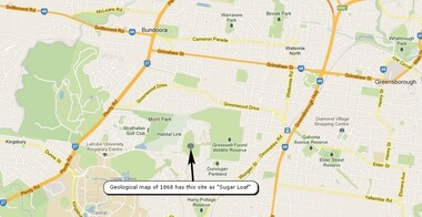
Map, Overlay/comparison Map for 1868 Greensborough-Bundoora Geological Map area, 1868_
... Overlay/comparison Map for 1868 Greensborough-Bundoora Geological Map area....bundoora...greensborough - maps...Overlay/comparison Map for 1868 Greensborough-Bundoora Geological Map area. Map ...This map is a comparison to the map at Item 2518, questioning the location of "Sugar Loaf". Annotation by GHS member Ian Bryant.Map copied from Google maps.Annotation on map.sugarloaf hill, bundoora, greensborough - maps -
 Greensborough Historical Society
Document, Parliament of Victoria, Ministers & Members search - the Hon. Colin Brooks (Bundoora), 23/04/2021
... Colin Brooks, MLA for Bundoora, taken from Parliament of Victoria - Ministers and Members website; and, map of the electoral district of Bundoora....2 p. text and colour photograph, with colour map of Bundoora Electoral District...Colin Brooks, MLA for Bundoora, taken from Parliament of Victoria - Ministers and Members website; and, map of the electoral district of Bundoora. brooks family victoria parliament colin brooks bundoora 2 p. text and colour photograph, with colour map of Bundoora Electoral District Ministers & Members search - the Hon. ...Biographical details of the Hon. Colin Brooks, MLA for Bundoora, taken from Parliament of Victoria - Ministers and Members website; and, map of the electoral district of Bundoora.2 p. text and colour photograph, with colour map of Bundoora Electoral Districtbrooks family, victoria parliament, colin brooks, bundoora -
 Eltham District Historical Society Inc
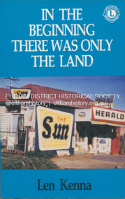
Book, Len Kenna, In the beginning there was only the land, 1988
... A book, published as part of the Australian Bicentenary Celebrations on the history of the suburb of Bundoora. ... Includes photographs, maps and index. Local history of the outer Melbourne suburb of Bundoora, from the original Wurundjeri people through to its development as a thriving suburb in the 1980s ; section entitled "The Aborigines" (pp.14-21) discusses the traditional way of life of the Wurundjeri people prior to European settlement....Eltham District Historical Society Inc 728 Main Rd Eltham melbourne A book, published as part of the Australian Bicentenary Celebrations on the history of the suburb of Bundoora. ... Includes photographs, maps and index. Local history of the outer Melbourne suburb of Bundoora, from the original Wurundjeri people through to its development as a thriving suburb in the 1980s ; section entitled "The Aborigines" (pp.14-21) discusses the traditional way of life of the Wurundjeri people prior to European settlement. ...A book, published as part of the Australian Bicentenary Celebrations on the history of the suburb of Bundoora. ... Includes photographs, maps and index. Local history of the outer Melbourne suburb of Bundoora, from the original Wurundjeri people through to its development as a thriving suburb in the 1980s ; section entitled "The Aborigines" (pp.14-21) discusses the traditional way of life of the Wurundjeri people prior to European settlement.bundoora, bundoora hall, hospitals, jane mckimmie, janefield, janefield church, john mckimmie, la trobe university, marvellous melbourne, mont park, mont park psychiatric hospital, plenty river, william shillinglaw, wurundjeri, yan yean reservoir -
 Ballarat Tramway Museum
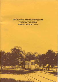
Document - Report, Melbourne and Metropolitan Tramways Board (MMTB), MMTB Annual Reports 1977 to 1979, 1977 to 1979
... Photos include first tram on Burwood Extension, Volvo bus Westgate freeway, K. J. Brennan, map of Bundoora extension, Box Hill tram, V214, vintage trams day 1979, MAN Bus, Swanston St at dusk and montage of painted W2's. ...Photos include first tram on Burwood Extension, Volvo bus Westgate freeway, K. J. Brennan, map of Bundoora extension, Box Hill tram, V214, vintage trams day 1979, MAN Bus, Swanston St at dusk and montage of painted W2's. ...Three copies of the Annual report of the MMTB for the years end 1977 to 1979. 3952.1 - "MMTB Annual Report 1977", brown card cover with a drawing of Z24 on the front cover, 24 pages, white paper, giving details of the MMTB Board, Officers, Introduction, Financial, Engineering, Industrial, Balance sheet, Summary of Income and Expenditure, Schedule of Debentures and Inscribed stock, auditors report, Schedule of tram and bus routes, and record of annual traffic receipts, passengers etc.. Photos include Z's in Bourke ST, after a heavy storm, new Volvo bus, display/advertising tram, Dandenong Rd, Route map board and Cathy Pacific advertisement. Printed by McCarron Bird. 3952.2 - "MMTB Annual Report 1978", gloss cover with a photo of Z18 in Wellington Parade on the front cover, 24 pages, white paper, giving details of the MMTB Board, Officers, Introduction, Financial, Engineering, Industrial, historical highlights, Balance sheet, Summary of Income and Expenditure, Schedule of Debentures and Inscribed stock, auditors report, Service Statistics, Schedule of tram and bus routes, and on inside back cover, route map. On back cover is a photo of Z20 in Wellington Parade. Photos include bus lane on Eastern Freeway, construction of Burwood Extension, first tram to Warragul Road, opening of Burwood tramway (1916), Volvo bus Bell St, upgraded computer installation, Volvo bus chassis, Z class bogie. Printed by McCarron Bird. 3952.3 - "MMTB Annual Report 1978-79", gloss card cover with a photo of Z 116 on the front cover, 24 pages, white paper, giving details of the MMTB Board, Officers, Introduction, Financial, Engineering, Industrial, historical highlights, Balance sheet, Summary of Income and Expenditure, Schedule of Debentures and Inscribed stock, auditors report, Service Statistics, Schedule of tram and bus routes, and on inside back cover, route map. On back cover is a photo of Z73, Nicholson St, Fitzroy. Photos include first tram on Burwood Extension, Volvo bus Westgate freeway, K. J. Brennan, map of Bundoora extension, Box Hill tram, V214, vintage trams day 1979, MAN Bus, Swanston St at dusk and montage of painted W2's. Printed by McCarron Bird.trams, tramways, mmtb, melbourne, annual reports, operations, trackwork -
 Greensborough Historical Society
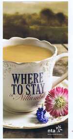
Leaflet, Nillumbik Tourist Association, Where to stay in Nillumbik, 17/10/2015
... Greensborough Historical Society 34A Glenauburn Road Lower Plenty Lower Plenty melbourne Lists 10 major tourist accommodations in: Bundoora, Diamond Creek, Eltham, Hurstbridge, Kangaroo Ground, Panton Hill, Research, St Andrews nillumbik Colour, printed both sides, map of area, A4 folded twice Where to stay in Nillumbik Leaflet Nillumbik Tourist Association ...Lists 10 major tourist accommodations in: Bundoora, Diamond Creek, Eltham, Hurstbridge, Kangaroo Ground, Panton Hill, Research, St AndrewsColour, printed both sides, map of area, A4 folded twicenillumbik -
 Greensborough Historical Society
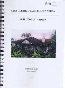
Book, Banyule Heritage Places Study, Volumes 1 and 2, 1999_07
... Bundoora). Vol 2: Building Citations - Part 2, Data Sheets L-Z deals mainly with houses in the Heidelberg, Eaglemont and Ivanhoe areas. historic houses ivanhoe eaglemont heidelberg banyule city council greensborough Approx 300 pages, col. illus and maps. ...Two volumes of the Banyule Heritage Places Study. Vol. 1: An Urban History [1837-1940s], covers Heidelberg, Ivanhoe, Greensborough and Janefield (Bundoora). Vol 2: Building Citations - Part 2, Data Sheets L-Z deals mainly with houses in the Heidelberg, Eaglemont and Ivanhoe areas. Approx 300 pages, col. illus and maps.historic houses, ivanhoe, eaglemont, heidelberg, banyule city council, greensborough -
 Greensborough Historical Society
Map, Greensborough c 1980s, 1980s
... Greensborough Historical Society 34A Glenauburn Road Lower Plenty Lower Plenty melbourne Map of Greensborough and surrounds showing bus routes servicing Eltham College. greensborough - maps eltham college bus routes public transport "Bundoora Retirement Village" marked in red pen at E20 Map of Greensborough and surrounds, black print with colour markings. ...Map of Greensborough and surrounds showing bus routes servicing Eltham College.Map of Greensborough and surrounds, black print with colour markings."Bundoora Retirement Village" marked in red pen at E20greensborough - maps, eltham college, bus routes, public transport -
 Greensborough Historical Society
Business Card, Clements Avenue Automotive, Clements Avenue Automotive, Bundoora, 2018c
... Greensborough Historical Society 34A Glenauburn Road Lower Plenty Lower Plenty melbourne Clements Avenue Automotive is an automobile repair and service business in Bundoora automotive repairs bundoora clements avenue bundoora Location map, contact details Business card, printed in colour both sides Clements Avenue Automotive, Bundoora Business Card Clements Avenue Automotive ...Clements Avenue Automotive is an automobile repair and service business in BundooraBusiness card, printed in colour both sidesLocation map, contact detailsautomotive repairs, bundoora, clements avenue bundoora -
 Greensborough Historical Society
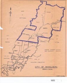
Map, City of Heidelberg, City of Heidelberg, 1962, 02/02/1962
... Map of City of Heidelberg showing boundaries of its six wards; North Ward is highlighted, covering Watsonia, Greensborough, part Bundoora, St Helena, Plenty, Yarrambat and Diamond Creek....Greensborough Historical Society 34A Glenauburn Road Lower Plenty Lower Plenty melbourne Map of City of Heidelberg showing boundaries of its six wards; North Ward is highlighted, covering Watsonia, Greensborough, part Bundoora, St Helena, Plenty, Yarrambat and Diamond Creek. city of heidelberg heidelberg - maps City of Heidelberg Scale: 1" to 1 ml. ...Map of City of Heidelberg showing boundaries of its six wards; North Ward is highlighted, covering Watsonia, Greensborough, part Bundoora, St Helena, Plenty, Yarrambat and Diamond Creek.Blue print mapCity of Heidelberg Scale: 1" to 1 ml. G.M.H. 2.2.62city of heidelberg, heidelberg - maps -
 Greensborough Historical Society
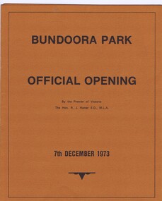
Memorabilia - Brochure, Bundoora Park, Official opening of Bundoora Park 1973, 06/12/1973
... Brochure for the official opening of Bundoora Park by the Premier of Victoria, The Hon. R.J. Hamer on 7th December 1973. Contents: Acquisition - work programme; Map; History of site; and, The discovery of an Aboriginal camp site and artifacts....Greensborough Historical Society 34A Glenauburn Road Lower Plenty Lower Plenty melbourne Brochure for the official opening of Bundoora Park by the Premier of Victoria, The Hon. R.J. Hamer on 7th December 1973. Contents: Acquisition - work programme; Map; History of site; and, The discovery of an Aboriginal camp site and artifacts. ...Brochure for the official opening of Bundoora Park by the Premier of Victoria, The Hon. R.J. Hamer on 7th December 1973. Contents: Acquisition - work programme; Map; History of site; and, The discovery of an Aboriginal camp site and artifacts.Bruce Morgan was the first Shire Secretary (1964-1983) of the Shire of Diamond Valley. This collection was compiled by his wife, Mavis Morgan, detailing the events they attended in their official capacity.4 p. brochure printed on tan cardboard black text, folded into thirdsbruce morgan, mavis morgan, bundoora park -
 Greensborough Historical Society
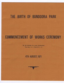
Memorabilia - Program, Victorian Government, The Birth of Bundoora Park: commencement of works ceremony 1971, 04/08/1971
... The Birth of Bundoora Park: commencement of works ceremony 4th August 1971, by the Minister for Local Government A J Hunt. A joint venture by the Victorian government, the City of Preston and Shire of Diamond Valley. Includes a map...Greensborough Historical Society 34A Glenauburn Road Lower Plenty Lower Plenty melbourne The Birth of Bundoora Park: commencement of works ceremony 4th August 1971, by the Minister for Local Government A J Hunt. A joint venture by the Victorian government, the City of Preston and Shire of Diamond Valley. Includes a map ...The Birth of Bundoora Park: commencement of works ceremony 4th August 1971, by the Minister for Local Government A J Hunt. A joint venture by the Victorian government, the City of Preston and Shire of Diamond Valley. Includes a map of the proposed development.Bruce Morgan was the first Shire Secretary (1964-1983) of the Shire of Diamond Valley. This collection was compiled by his wife, Mavis Morgan, detailing the events they attended in their official capacityBrochure printed in black on brown card, includes map.bruce morgan, mavis morgan, shire of diamond valley, bundoora park -
 Greensborough Historical Society
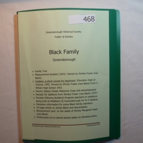
Folder, Black Family - Greensborough, 1900o
... Contents: Family tree; small school books from family member; copy of map and advertisement for Watsonia Electric Station Estate; receipts; cemetery information; article on James Black and descendants; copies of un-named photos taken on Bundoora farm....Greensborough Historical Society 34A Glenauburn Road Lower Plenty Lower Plenty melbourne Contents: Family tree; small school books from family member; copy of map and advertisement for Watsonia Electric Station Estate; receipts; cemetery information; article on James Black and descendants; copies of un-named photos taken on Bundoora farm. ...Contents: Family tree; small school books from family member; copy of map and advertisement for Watsonia Electric Station Estate; receipts; cemetery information; article on James Black and descendants; copies of un-named photos taken on Bundoora farm.The Black family owned a large portion of land from Greensborough to Watsonia. This collection is partly from family members.20-page plastic binder, green cover. Contains documents relating to the Black family of Greensborough and Watsonia.Collected by Greensborough Historical Society. Folder commenced 2012black family, shirley fraser, james black, watsonia electric station estate -
 Greensborough Historical Society
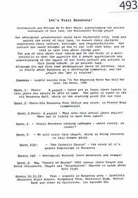
Article, Let's visit Bundoora, 1841o
... This collection of notes aims 'for a deeper appreciation and understanding of the impact of our lives; culture and actions;.in Bundoora; a developing community'. Includes copies of uncited articles; photos and maps....Greensborough Historical Society 34A Glenauburn Road Lower Plenty Lower Plenty melbourne This collection of notes aims 'for a deeper appreciation and understanding of the impact of our lives; culture and actions;.in Bundoora; a developing community'. Includes copies of uncited articles; photos and maps. ...This collection of notes aims 'for a deeper appreciation and understanding of the impact of our lives; culture and actions;.in Bundoora; a developing community'. Includes copies of uncited articles; photos and maps.Background information on Bundoora in the 20th century.Collection of articles, possibly notes from an oral presentation. Complete document available at GHS."Contents largely sourced from "In the beginning there was only the land", Len Kenna, 1988." - note on page 1.bundoora -
 Greensborough Historical Society
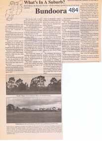
Newspaper Clipping, Bundoora: What's in a Suburb?, 16/09/2000
... Includes information on hospitals in the area - Larundel, Mont Park, bundoora mont park 1 page, text, photos and map. Bundoora: What's in a Suburb? ...A short history of Bundoora from its earliest subdivision in 1838 to the end of the 20th century. Includes information on hospitals in the area - Larundel, Mont Park, 1 page, text, photos and map.bundoora, mont park -
 Greensborough Historical Society
Article, The 1909 "Battle of Greensborough" / by John Gibson, 1909_
... This is the text of a presentation by John Gibson at the April 2013 meeting of GHS. sugarloaf hill bundoora john gibson greswell hill latrobe house 2 pages, text, map and photograph. ...In 1909 military exercises were held in the Greensborough area. In this researched article the site is identified and activities related.This is the text of a presentation by John Gibson at the April 2013 meeting of GHS.2 pages, text, map and photograph.sugarloaf hill, bundoora, john gibson, greswell hill, latrobe house -
 Ballarat Tramway Museum
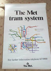
Poster, Metropolitan Transit Authority (MTA), "The Met / tram system", c1988
... Date of map 1988c, shows the St. Kilda and Port Melbourne light rail, Bundoora and the "The Met" logo. ...Date of map 1988c, shows the St. Kilda and Port Melbourne light rail, Bundoora and the "The Met" logo. ...Diagrammatic poster or map of "The Met / tram system" showing a plan with route numbers, zones and peak system route numbers with an enlarged central Melbourne area. Date of map 1988c, shows the St. Kilda and Port Melbourne light rail, Bundoora and the "The Met" logo. Printed on art paper. Has a telephone number for further information. Stored rolled. St. Kilda and Port Melbourne light rail opened late 1987. The Met replaced by the Public Transport Corporation 1/7/1989 - See reference. Two copies held. See Time-line history of Melbourne's Government Cable and Electric Trams and Buses.trams, tramways, melbourne, map, the met, tram routes -
University of Melbourne, Burnley Campus Archives
Map - Photocopy, La Trobe University Bundoora Campus, 2000
... 2 photocopies and 1 enlarged photocopy of map reproduced from Melway Street Directory, Edition 29, of La Trobe University Bundoora Campus....La Trobe University Bundoora Campus Map Photocopy ...2 photocopies and 1 enlarged photocopy of map reproduced from Melway Street Directory, Edition 29, of La Trobe University Bundoora Campus.la trobe university, bundoora campus -
 Melbourne Tram Museum
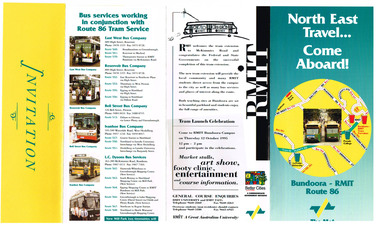
Pamphlet, The Met, "North East Travel Come Aboard - Bundoora - RMIT Route 86", Oct. 1995
... Gives details of the extension to the RMIT Campus at Bundoora, associated bus routes and the companies operating them, RMIT launch celebrations, and a map. ...Gives details of the extension to the RMIT Campus at Bundoora, associated bus routes and the companies operating them, RMIT launch celebrations, and a map. ...Folded full colour printed on glossy paper pamphlet titled "North East Travel Come Aboard - Bundoora - RMIT Route 86" for the opening of the Bundoora tramway extension 12 October 1995, with a complimentary ticket. Gives details of the extension to the RMIT Campus at Bundoora, associated bus routes and the companies operating them, RMIT launch celebrations, and a map. Published by The Met, has logos. Two copies held.trams, tramways, bundoora, route 86, opening, rmit -
 Melbourne Tram Museum
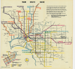
Map, Melbourne & Metropolitan Tramways Board (MMTB), "Tram Route Guide", Jun. 1979
... Map dated 6/79, showing proposed extension to Bundoora, routes with route numbers and names of main destinations. ...Map dated 6/79, showing proposed extension to Bundoora, routes with route numbers and names of main destinations. ...Full colour map or poster printed on clear plastic with an adhesive peel off backing sheets, titled "Tram Route Guide". Map dated 6/79, showing proposed extension to Bundoora, routes with route numbers and names of main destinations. Has notes about the services, weekend and telephone numbers for information. 1979 Two copies held. See Reg Item 3765 for a larger version of this map.trams, tramways, mmtb, map, routes, posters -
 Melbourne Tram Museum
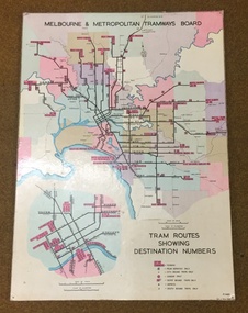
Map, Melbourne & Metropolitan Tramways Board, Del J. Chau, "Tram Routes showing destination numbers", 1972
... Map dated 1972, showing routes with route numbers, including short working, names of main destinations, roads, railway stations and rail lines, municipalities, rivers, scales, city section in detail, depots and Sunday only services. In bottom right hand corner has number P.14431, Del J. Chau 1972. The original has been altered to show the Bundoora...Map dated 1972, showing routes with route numbers, including short working, names of main destinations, roads, railway stations and rail lines, municipalities, rivers, scales, city section in detail, depots and Sunday only services. In bottom right hand corner has number P.14431, Del J. Chau 1972. The original has been altered to show the Bundoora ...Titled "Tram Routes showing destination numbers". Map dated 1972, showing routes with route numbers, including short working, names of main destinations, roads, railway stations and rail lines, municipalities, rivers, scales, city section in detail, depots and Sunday only services. In bottom right hand corner has number P.14431, Del J. Chau 1972. The original has been altered to show the Bundoora, La Trobe University and East Burwood lines and the change to Airport West. Type of map that was placed on the rear of the driver's doors of a W Class tramcar.Demonstrates a MMTB produced map used in trramcars.Full colour map or poster printed on heavy cardboard.trams, tramways, mmtb, map, routes -
 Melbourne Tram Museum
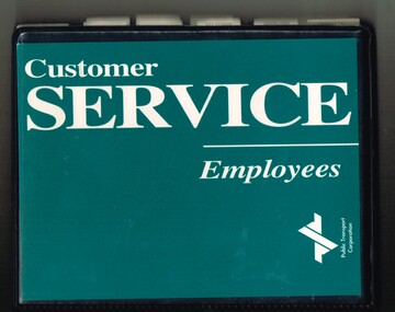
Book, Public Transport Corporation (PTC), "Customer Service Employees", c1995
... Contains approx. 120 sheets with information about Melbourne's public transport including general information, maps, fares, Met Tickets (3 zones), disabilities, sports and entertainment Map, Hospitals, AFL Grounds, Bus & Tram Services, Night Rider Bus Services and basic first aid. The map shows tram line to Bundoora but no services to Docklands, the Altona - Laverton rail line shown. ...Contains approx. 120 sheets with information about Melbourne's public transport including general information, maps, fares, Met Tickets (3 zones), disabilities, sports and entertainment Map, Hospitals, AFL Grounds, Bus & Tram Services, Night Rider Bus Services and basic first aid. The map shows tram line to Bundoora but no services to Docklands, the Altona - Laverton rail line shown. ...Black vinyl covered two ring folder titled "Customer Service Employees", with the Public Transport Corporation Logo printed on dark green paper. Contains approx. 120 sheets with information about Melbourne's public transport including general information, maps, fares, Met Tickets (3 zones), disabilities, sports and entertainment Map, Hospitals, AFL Grounds, Bus & Tram Services, Night Rider Bus Services and basic first aid. The map shows tram line to Bundoora but no services to Docklands, the Altona - Laverton rail line shown. Gives details of Ansett airlines office. Book not dated as such. Estimated date - mid 1990's, prior to Metcards, still using Met tickets.trams, tramways, ptc, the met, tickets, information, melbourne, buses -
 Melbourne Tram Museum
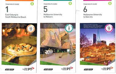
Ephemera - Tram Route Guides, Public Transport Victoria (PTV), "Tram Route Guide", Feb. 2016
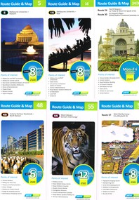
... Melbourne Tram Museum 8 Wallen Road Hawthorn melbourne Trams tramways Timetables Maps Route 1 Route 5 Route 6 Route 8 Route 11 Route 16 Route 132 Route 19 Route 30 Route 48 Route 55 Route 57 Route 59 Route 64 Route 67 Route 70 Route 72 Route 75 Route 78 Route 82 Route 86 Route 96 Route 109 East Coburg West Coburg Airport West North Coburg South Melbourne Malvern Glen Iris Moreland Toorak West Maribyrnong Wattle Park Docklands Camberwell Vermont South Footscray Moonee Ponds St Vincent's Plaza Victoria Gardens East Brighton North Richmond Balaclava Bundoora East Brunswick West Preston Kew North Balwyn Carnegie Box Hill Item 11 has the "5" changed to "8" in Texta - see history of object. ...Set of 18 Tram Route Guides, published during 2016. Each comprises a vertical DL folded sheet, full colour for the nominated routes, with Yarra Trams and PTV logos, listing the stops, interchanges with bus and other tram services, ticketing zones, estimated frequencies with adverts for Night tram services, TramTracker and Myki tickets. .1 - Route 1 - East Coburg to South Melbourne Beach .2 - Route 5 - Melbourne University to Malvern .3 - Route 6 - Melbourne University to Glen Iris .4 - Route 8 - Moreland to Toorak .5 -Route 57 - West Maribyrnong to Flinders St Station (2 copies) .6 - Route 70 - Wattle Park to Waterfront City Docklands .7 - Route 72 - Melbourne University to Camberwell .8 - Route 75 - Vermont South to Etihad Stadium / Bourke St Docklands .9 - Route 82 - Footscray to Moonee Ponds .10 - Route 19 - North Coburg to Flinders St Station .11 - Route 55 - West Coburg to Domain Interchange (two copies held) .12 - Route 59 - Airport West to Flinders St Station .13 - Route 30 - St Vincent's Plaza to Ethida Stadium Docklands .14 - Route 12 - Victoria Gardens to St Kilda / Fitzroy St .15 - Route 64 - Melbourne University to East Brighton .16 - Route 78 - North Richmond to Balaclava (via Prahran) .17 - Route 86 - Bundoora (RMIT) to Waterfront City Docklands .18 - Route 96 - East Brunswick to St Kilda Beach .19 - Route 11 - West Preston to Victoria Harbour Docklands ,20 - Route 16 - Melbourne University to Kew via St Kilda .21 - Route 48 - North Balwyn to Victoria Harbour Docklands .22 - Route 67 - Melbourne University to Carnegie .23 - Route 109 - Box Hill to Port Melbourne See Reg Item 2396 for 2012, 2939 for 2015 and 2940 for 2014 versions Items .13 to .18 added 2/9/18Item 11 has the "5" changed to "8" in Texta - see history of object.trams, tramways, timetables, maps, route 1, route 5, route 6, route 8, route 11, route 16, route 132, route 19, route 30, route 48, route 55, route 57, route 59, route 64, route 67, route 70, route 72, route 75, route 78, route 82, route 86, route 96, route 109, east coburg, west coburg, airport west, north coburg, south melbourne, malvern, glen iris, moreland, toorak, west maribyrnong, wattle park, docklands, camberwell, vermont south, footscray, moonee ponds, st vincent's plaza, victoria gardens, east brighton, north richmond, balaclava, bundoora, east brunswick, west preston, kew, north balwyn, carnegie, box hill -
 Melbourne Tram Museum
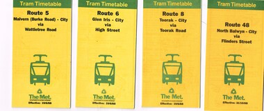
Ephemera - Timetable/s, The Met, "The Met Tram Timetable", 1987 and 1988
... map, sections and fares and phone contact numbers. Route 5 - Malvern (Burke Road) - City via Wattletree Road - June 1988 Route 6 - Glen Iris - City via High St - June 1988 Route 8 - Toorak - City - June 1988 Route 42 - Mont Albert - City - August 1988 Route 48 - North Balwyn - City via Flinders St - Oct. 1988 Route 67 - Carnegie - City - Sept. 1987 Route 69 - Kew Cotham Road - St Kilda Beach via Glenferrie Road - June 1988 Route 86 - Bundoora - City via Preston - Aug. 1988 Route 72 - Camberwell - City via Malvern Road - June 1988 Route 75 - East Burwood - City via Flinders St - Feb. 1988 Route 96 - East Brunswick - St Kilda Beach (Light Rail) - Oct 1988...map, sections and fares and phone contact numbers. Route 5 - Malvern (Burke Road) - City via Wattletree Road - June 1988 Route 6 - Glen Iris - City via High St - June 1988 Route 8 - Toorak - City - June 1988 Route 42 - Mont Albert - City - August 1988 Route 48 - North Balwyn - City via Flinders St - Oct. 1988 Route 67 - Carnegie - City - Sept. 1987 Route 69 - Kew Cotham Road - St Kilda Beach via Glenferrie Road - June 1988 Route 86 - Bundoora - City via Preston - Aug. 1988 Route 72 - Camberwell - City via Malvern Road - June 1988 Route 75 - East Burwood - City via Flinders St - Feb. 1988 Route 96 - East Brunswick - St Kilda Beach (Light Rail) - Oct 1988 Yields information about Melbourne tram timetables in 1988 Trams tramways The Met Timetables Melbourne Fares Route 5 Route 6 Route 8 Route 48 Route 67 Route 86 Route 72 Route 75 Route 96 route 42 Set of 11 The Met Tram timetables, folded sheets, 8 -10 sections "The Met Tram Timetable" Ephemera Timetable/s The Met ...Timetables - , providing timetables for specific routes, day of week giving information on tram times at specific time points, route map, sections and fares and phone contact numbers. Route 5 - Malvern (Burke Road) - City via Wattletree Road - June 1988 Route 6 - Glen Iris - City via High St - June 1988 Route 8 - Toorak - City - June 1988 Route 42 - Mont Albert - City - August 1988 Route 48 - North Balwyn - City via Flinders St - Oct. 1988 Route 67 - Carnegie - City - Sept. 1987 Route 69 - Kew Cotham Road - St Kilda Beach via Glenferrie Road - June 1988 Route 86 - Bundoora - City via Preston - Aug. 1988 Route 72 - Camberwell - City via Malvern Road - June 1988 Route 75 - East Burwood - City via Flinders St - Feb. 1988 Route 96 - East Brunswick - St Kilda Beach (Light Rail) - Oct 1988Yields information about Melbourne tram timetables in 1988Set of 11 The Met Tram timetables, folded sheets, 8 -10 sectionstrams, tramways, the met, timetables, melbourne, fares, route 5, route 6, route 8, route 48, route 67, route 86, route 72, route 75, route 96, route 42 -
 Melbourne Tram Museum
Ephemera - Tram Route Guides, Public Transport Victoria (PTV), "Tram Route Guide", Oct. 2011 to Oct 2012
... Melbourne Tram Museum 8 Wallen Road Hawthorn melbourne Trams tramways Timetables Maps Route 1 Route 3/3a Route 5 Route 6 Route 8 Route 11 Route 16 Route 24 Route 30 Route 31 Route 48 Route 55 Route 57 Route 59 Route 64 Route 67 Route 70 Route 72 Route 75 Route 78 Route 79 Route 82 Route 86 Route 95 Route 96 Route 109 Route 112 East Coburg South Melbourne Malvern West Maribyrnong Airport West Docklands North Balwyn West Coburg Domain Interchange North Richmond Prahran East Brunswick St Kilda Vermont South Footscray Moonee Ponds Kew St Vincent's Plaza Preston Wattle Park Bundoora Museum South Melbourne Beach East Coburg East Malvern Glen Iris Toorak Moreland East Brighton Carnegie Camberwell Box Hill Port Melbourne Set of 23 Tram Route Guides, published during 2011 or 2012. ...Set of 23 Tram Route Guides, published during 2011 or 2012. Each comprises a vertical DL folded sheet, full colour for the nominated routes, with Yarra Trams, Myki and TramTracker logos, listing the stops, interchanges with bus and other tram services, ticketing zones, estimated frequencies with adverts for Night tram services, TramTracker and Myki tickets. .1 - Route 5 - Melbourne University to Malvern .2 - Route 16 - Melbourne University to Kew .3 - Route 24 and 30 - North Balwyn - Latrobe St and St Vincent's Plaza - Etihad Stadium .4 - Route 48 - North Balwyn - Victoria Harbour Docklands .5 - Route 55 - West Coburg - Domain Interchange .6 - Route 57 - West Maribyrnong to Flinders St Station .7 - Route 59 - Airport West - City .8 - Route 75 - City - Vermont South .9 - Route 78 and 79 - North Richmond - Prahran or St Kilda Beach .10 - Route 82 - Footscray to Moonee Ponds .11 - Route 96 - East Brunswick - St Kilda Beach .12 - ditto .13 - Route 112/11 - West Preston - St Kilda, West Preston - Victoria Harbour Docklands .14 - Route 70 - Wattle Park - Waterfront City Docklands .15 - Route 86/95 - Bundoora - Waterfront City Docklands and Melbourne Museum - City .16 - Route 1 - East Coburg - South Melbourne Beach .17 - Route 3/3a - Melbourne University to East Malvern .18 - Route 6 - Melbourne University to - Glen Iris .19 - Route 8 - Moreland to Toorak .20 - Route 64 - Melbourne University to East Brighton .21 - Route 67 - Melbourne University to Carnegie .22 - Route 72 - Melbourne University to Camberwell .23 - Route 109 - Box Hill - Port Melbourne and Route 31 - Hoddle St - Victoria Harbour - Docklands .24 - Route 75 - Vermont South - dated 10/2011 See Reg Item 2278 for 2016 versionstrams, tramways, timetables, maps, route 1, route 3/3a, route 5, route 6, route 8, route 11, route 16, route 24, route 30, route 31, route 48, route 55, route 57, route 59, route 64, route 67, route 70, route 72, route 75, route 78, route 79, route 82, route 86, route 95, route 96, route 109, route 112, east coburg, south melbourne, malvern, west maribyrnong, airport west, docklands, north balwyn, west coburg, domain interchange, north richmond, prahran, east brunswick, st kilda, vermont south, footscray, moonee ponds, kew, st vincent's plaza, preston, wattle park, bundoora, museum, south melbourne beach, east coburg, east malvern, glen iris, toorak, moreland, east brighton, carnegie, camberwell, box hill, port melbourne -
 Melbourne Tram Museum
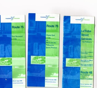
Ephemera - Timetable/s, Yarra Trams, Set of five timetable books - 2002. Provide details about Yarra Trams, Metcards, route map, timing points and route description, 8/2000 to 9/2002
... Has Route 48 on the reverse of the book. .4 - printed 28 page book, blue green cover stapled timetable for "Route 86 - Bundoora / RMIT - Colonial Stadium via Bourke St" tram service, dated September 2002. .5 - printed 32 page book, blue green cover stapled timetable for "Route 109 - Port Melbourne - Mont Albert" and La Trobe St services (back of booklet) tram services, dated September 2001. Set of five timetable books - 2002. Provide details about Yarra Trams, Metcards, route map ...Set of five timetable books - 2002. Provide details about Yarra Trams, Metcards, route map, timing points and route description. .1 - printed 24 page book, blue green cover stapled timetable for "Route 75 - East Burwood - City" tram service, dated August 2000. .2 - printed 24 page book, blue green cover stapled timetable for "Route 70 - Wattle Park - City" tram service, dated December 2000. .3 - printed 24 page book, blue green cover stapled timetable for "La Trobe Street Services - East Melbourne" and "North Balwyn - City" tram service, dated September 2001. Covers Route 48, 24, 27, 30 and 34. Has Route 48 on the reverse of the book. .4 - printed 28 page book, blue green cover stapled timetable for "Route 86 - Bundoora / RMIT - Colonial Stadium via Bourke St" tram service, dated September 2002. .5 - printed 32 page book, blue green cover stapled timetable for "Route 109 - Port Melbourne - Mont Albert" and La Trobe St services (back of booklet) tram services, dated September 2001.trams, tramways, tickets, yarra trams, tram services, timetables, la trobe st, route 70, route 75, route 109, route 86, route 86, route 109, route 48, route 24, route 27, route 30, route 34