Showing 47 items matching "burwood highway burwood east"
-
 Whitehorse Historical Society Inc.
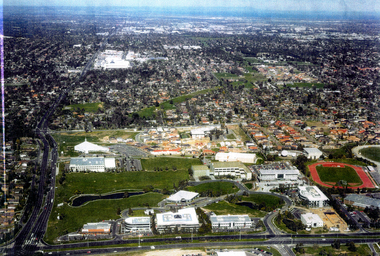
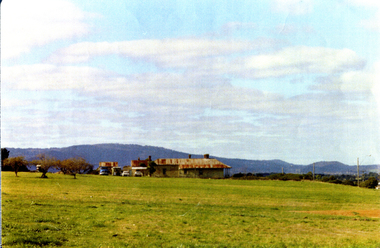
Photograph - Ariel Photograph, Tally Ho Office Park 1995, 1995
... burwood east...burwood highway burwood east...Aerial view of Tally Ho Office Park on corner of Springvale Road & Burwood Highway, East Burwood. Site partly developed. Shows East Burwood Reserve (part) and Bill Sewart Athletics Track. ...Whitehorse Historical Society Inc. 2-10 Deep Creek Road Mitcham melbourne lend lease development pty ltd tally ho office park springvale road burwood east burwood highway burwood east bill sewart athletic track Aerial view of Tally Ho Office Park on corner of Springvale Road & Burwood Highway, East Burwood. ...Aerial view of Tally Ho Office Park on corner of Springvale Road & Burwood Highway, East Burwood. Site partly developed. Shows East Burwood Reserve (part) and Bill Sewart Athletics Track. Photo taken facing Burwood Highway.lend lease development pty ltd, tally ho office park, springvale road burwood east, burwood highway burwood east, bill sewart athletic track -
 Whitehorse Historical Society Inc.
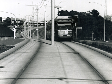
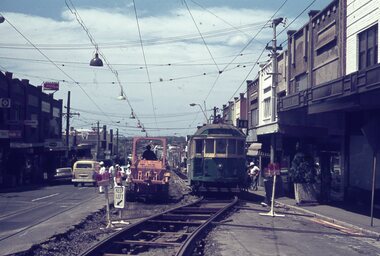
Photograph - B/W Photograph, Tram on Burwood Highway East Burwood, 1994
... Tram on Burwood Highway East Burwood...Whitehorse Historical Society Inc. 2-10 Deep Creek Road Mitcham melbourne burwood highway blackburn south trams Black and white photograph of a tram on the Burwood Highway, coming east from the Middleborough intersection and shopping centre. 1994 Tram on Burwood Highway East Burwood Photograph B/W Photograph ...Black and white photograph of a tram on the Burwood Highway, coming east from the Middleborough intersection and shopping centre. 1994burwood highway blackburn south, trams -
 Whitehorse Historical Society Inc.
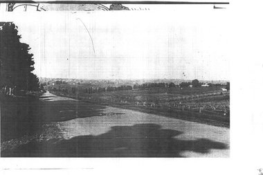
Map, Springvale Road, 1975
... Burwood East...Burwood Highway...Whitehorse Historical Society Inc. 2-10 Deep Creek Road Mitcham melbourne Aerial photographs Vermont South Highbury Road Burwood East Burwood Highway Burwood East Burwood East Aerial photograph of area around cnr. of Springvale Road and Burwood Highway, south past Highbury Road and East in Vermont South. ...Aerial photograph of area around cnr. of Springvale Road and Burwood Highway, south past Highbury Road and East in Vermont South.Aerial photograph of area around cnr. of Springvale Road and Burwood Highway, south past Highbury Road and East in Vermont South.Aerial photograph of area around cnr. of Springvale Road and Burwood Highway, south past Highbury Road and East in Vermont South.aerial photographs, vermont south, highbury road, burwood east, burwood highway, burwood east, burwood east -
Whitehorse Historical Society Inc.
Document, A Century and a bit of Methodism, 2006
... East Burwood Methodist Church...Methodist Church...Burwood Highway...Whitehorse Historical Society Inc. 2-10 Deep Creek Road Mitcham melbourne Nunawading Primitive Methodist Church East Burwood Methodist Church Methodist Church Burwood Highway Burwood East Burwood East The Early history of Nunawading Primitive Methodist Church (1856-1902) and the East Burwood Methodist Church (1902-1963), by David Street. ...The Early history of Nunawading Primitive Methodist Church (1856-1902) and the East Burwood Methodist Church (1902-1963), by David Street.The Early history of Nunawading Primitive Methodist Church (1856-1902) and the East Burwood Methodist Church (1902-1963), by David Street.The Early history of Nunawading Primitive Methodist Church (1856-1902) and the East Burwood Methodist Church (1902-1963), by David Street.nunawading primitive methodist church, east burwood methodist church, methodist church, burwood highway, burwood east, burwood east -
Whitehorse Historical Society Inc.
Map, Springvale Road, 1981
... Burwood East...Springvale Road...Burwood East...Burwood Highway...Whitehorse Historical Society Inc. 2-10 Deep Creek Road Mitcham melbourne Aerial photographs Burwood East Springvale Road Burwood East Burwood Highway Burwood East Sevenoaks Road Burwood East Highbury Road Burwood East Aerial photograph of area including cnr. ...Aerial photograph of area including cnr. Springvale Road and Burwood Highway, south past Highbury Road and west to Sevenoaks Road.Aerial photograph of area including cnr. Springvale Road and Burwood Highway, south past Highbury Road and west to Sevenoaks Road.Aerial photograph of area including cnr. Springvale Road and Burwood Highway, south past Highbury Road and west to Sevenoaks Road.aerial photographs, burwood east, springvale road, burwood east, burwood highway, burwood east, sevenoaks road, burwood east, highbury road, burwood east -
Whitehorse Historical Society Inc.
Legal record - Land Title, Springvale Road, 1960
... Burwood East...Burwood Highway...Whitehorse Historical Society Inc. 2-10 Deep Creek Road Mitcham melbourne Aerial photographs Springvale Road Burwood East Burwood Highway Burwood East Highbury Road Burwood East Vermont South Aerial photograph of cnr. ...Aerial photograph of cnr. Springvale Road and Burwood Highway, south past Highbury Road and east to Vermont South.Aerial photograph of cnr. Springvale Road and Burwood Highway, south past Highbury Road and east to Vermont South.Aerial photograph of cnr. Springvale Road and Burwood Highway, south past Highbury Road and east to Vermont South.aerial photographs, springvale road, burwood east, burwood highway, burwood east, highbury road, burwood east, vermont south -
Whitehorse Historical Society Inc.
Map, Springvale Road, 1987
... Burwood East...Highbury Road...Burwood East...Burwood Highway...Whitehorse Historical Society Inc. 2-10 Deep Creek Road Mitcham melbourne Aerial photographs Blackburn Road Burwood East Highbury Road Burwood East Burwood Highway Burwood East Springvale Road Burwood East Burwood East Aerial photograph of cnr Springvale Road and Burwood Highway, south past Highbury Road and west past Blackburn Road. ...Aerial photograph of cnr Springvale Road and Burwood Highway, south past Highbury Road and west past Blackburn Road.Aerial photograph of cnr Springvale Road and Burwood Highway, south past Highbury Road and west past Blackburn Road.Aerial photograph of cnr Springvale Road and Burwood Highway, south past Highbury Road and west past Blackburn Road.aerial photographs, blackburn road, burwood east, highbury road, burwood east, burwood highway, burwood east, springvale road, burwood east, burwood east -
Whitehorse Historical Society Inc.
Map, Springvale Road, 1968
... Burwood East...Burwood Highway...Whitehorse Historical Society Inc. 2-10 Deep Creek Road Mitcham melbourne Aerial photographs Highbury Road Burwood East Burwood Highway Burwood East Springvale Road Burwood East Aerial photograph of cnr Springvale Road and Burwood Highway, south past Highbury Road. ...Aerial photograph of cnr Springvale Road and Burwood Highway, south past Highbury Road.Aerial photograph of cnr Springvale Road and Burwood Highway, south past Highbury Road.Aerial photograph of cnr Springvale Road and Burwood Highway, south past Highbury Road.aerial photographs, highbury road, burwood east, burwood highway, burwood east, springvale road, burwood east -
Whitehorse Historical Society Inc.
Document, East Burwood reserve, 1992
... ...East Burwood Reserve...Burwood Highway...Whitehorse Historical Society Inc. 2-10 Deep Creek Road Mitcham melbourne City of Nunawading East Burwood Reserve Burwood Highway Burwood East Nos 292 - 336 History and map of East Burwood Reserve - includes details of acquisition of land History and map of East Burwood Reserve - includes details of acquisition of land East Burwood reserve Document Document ...History and map of East Burwood Reserve - includes details of acquisition of landHistory and map of East Burwood Reserve - includes details of acquisition of landHistory and map of East Burwood Reserve - includes details of acquisition of landcity of nunawading, east burwood reserve, burwood highway, burwood east, nos 292 - 336 -
 Whitehorse Historical Society Inc.
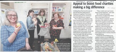
Article, Uniting East Burwood, 2018
... east burwood...burwood highway...Whitehorse Historical Society Inc. 2-10 Deep Creek Road Mitcham melbourne uniting east burwood burwood highway burwood east no. 220 Uniting East Burwood has received a $5,000 donation from the Feed Melbourne Appeal to provide food for the needy. ...Uniting East Burwood has received a $5,000 donation from the Feed Melbourne Appeal to provide food for the needy.Uniting East Burwood has received a $5,000 donation from the Feed Melbourne Appeal to provide food for the needy.Uniting East Burwood has received a $5,000 donation from the Feed Melbourne Appeal to provide food for the needy.uniting east burwood, burwood highway, burwood east no. 220 -
 Whitehorse Historical Society Inc.
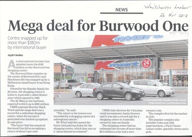
Article, Mega Deal For Burwood One, 2018
... burwood one...burwood highway...burwood east...Whitehorse Historical Society Inc. 2-10 Deep Creek Road Mitcham melbourne burwood one burwood highway burwood east Burwood One shopping centre was purchased for more than $180 million by an international buyer. ...Burwood One shopping centre was purchased for more than $180 million by an international buyer.Burwood One shopping centre was purchased for more than $180 million by an international buyer.Burwood One shopping centre was purchased for more than $180 million by an international buyer.burwood one, burwood highway, burwood east -
 Whitehorse Historical Society Inc.
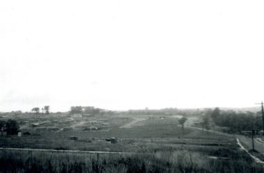
Photograph, Subdivision of Area of Burwood, 1971
... burwood east...springvale road...burwood highway...Whitehorse Historical Society Inc. 2-10 Deep Creek Road Mitcham melbourne highbury road burwood east springvale road burwood highway burwood east Subdivision Black and white photo of Subdivision of Area of Burwood, Springvale and Highbury Roads. ...Black and white photo of Subdivision of Area of Burwood, Springvale and Highbury Roads.highbury road, burwood east, springvale road, burwood highway burwood east, subdivision -
 Whitehorse Historical Society Inc.
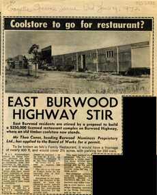
Article, East Burwood highway stir, 1972
... Burwood Highway...Burwood East...East Burwood residents are angry about a proposal for a licensed restaurant where an old timber cool store exists on Burwood Highway....Whitehorse Historical Society Inc. 2-10 Deep Creek Road Mitcham melbourne Burwood Highway Burwood East Conos Theo Restaurants James Peter Gawler David Cool stores East Burwood residents are angry about a proposal for a licensed restaurant where an old timber cool store exists on Burwood Highway. ...East Burwood residents are angry about a proposal for a licensed restaurant where an old timber cool store exists on Burwood Highway.East Burwood residents are angry about a proposal for a licensed restaurant where an old timber cool store exists on Burwood Highway.East Burwood residents are angry about a proposal for a licensed restaurant where an old timber cool store exists on Burwood Highway.burwood highway, burwood east, conos, theo, restaurants, james, peter, gawler, david, cool stores -
Whitehorse Historical Society Inc.
Article, Former Site of Burwood Brickworks Sold, 2014
... ...Burwood Highway Burwood East...Australand Brickworks Reading Entertainment Australia Pty Ltd Burwood Highway Burwood East Middleborough Road Burwood East Eley Road Burwood East The site of the former Burwood Brickworks. ...The site of the former Burwood Brickworks.The site of the former Burwood Brickworks has been purchased by Australand from Reading Entertainment Australia Pty Ltd..The site of the former Burwood Brickworks.australand, brickworks, reading entertainment australia pty ltd, burwood highway burwood east, middleborough road burwood east, eley road burwood east -
Whitehorse Historical Society Inc.
Map, City of Nunawading Street and Block Map
... ...Burwood Highway Burwood East...Whitehorse Historical Society Inc. 2-10 Deep Creek Road Mitcham melbourne Scale: 1:10,000. with enlargement, Canterbury Road South to Burwood Highway. Canterbury Road Nunawading Burwood Highway Burwood East City of Nunawading City of Nunawading Street and Block map. ...City of Nunawading Street and Block map.City of Nunawading Street and Block map. Scale: 1:10,000. with enlargement, Canterbury Road South to Burwood Highway.City of Nunawading Street and Block map. canterbury road nunawading, burwood highway burwood east, city of nunawading -
Whitehorse Historical Society Inc.
Map, Springvale Road, 1990
... ...Burwood Highway...Burwood East...Whitehorse Historical Society Inc. 2-10 Deep Creek Road Mitcham melbourne Aerial photographs Morack Road Vermont South Burwood Highway Burwood East Springvale Road Burwood East Highbury Road Burwood East Burwood East Vermont South Aerial photograph of cnr Springvale Road and Burwood Highway, south past Highbury Road, west to Middleborough Road and east to Morack Road Vermont South. ...Aerial photograph of cnr Springvale Road and Burwood Highway, south past Highbury Road, west to Middleborough Road and east to Morack Road Vermont South.Aerial photograph of cnr Springvale Road and Burwood Highway, south past Highbury Road, west to Middleborough Road and east to Morack Road Vermont South.Aerial photograph of cnr Springvale Road and Burwood Highway, south past Highbury Road, west to Middleborough Road and east to Morack Road Vermont South.aerial photographs, morack road, vermont south, burwood highway, burwood east, springvale road, burwood east, highbury road, burwood east, burwood east, vermont south -
Whitehorse Historical Society Inc.
Article, Route opens, 1993
... ...Burwood Highway...Burwood East...Whitehorse Historical Society Inc. 2-10 Deep Creek Road Mitcham melbourne Tram services Burwood Highway Burwood East Article on the opening of the East Burwood tram route extension, July 1993 Article on the opening of the East Burwood tram route extension, July 1993 Route opens Article Article ...Article on the opening of the East Burwood tram route extension, July 1993Article on the opening of the East Burwood tram route extension, July 1993Article on the opening of the East Burwood tram route extension, July 1993tram services, burwood highway, burwood east -
Whitehorse Historical Society Inc.
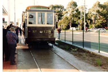
Article, One of the first trams, 1993
... ...Burwood Highway...Burwood East...Whitehorse Historical Society Inc. 2-10 Deep Creek Road Mitcham melbourne Tram services Burwood Highway Burwood East Photo with caption of one of the first trams to run along the East Burwood extension, July 1993 Photo with caption of one of the first trams to run along the East Burwood extension, July 1993 One of the first trams Article Article ...Photo with caption of one of the first trams to run along the East Burwood extension, July 1993Photo with caption of one of the first trams to run along the East Burwood extension, July 1993Photo with caption of one of the first trams to run along the East Burwood extension, July 1993tram services, burwood highway, burwood east -
 Whitehorse Historical Society Inc.
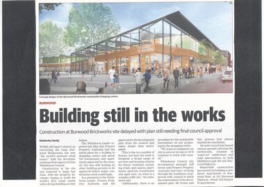
Article, Burwood Brickworks Shopping Centre, 2018
... ...burwood highway...burwood east...Whitehorse Historical Society Inc. 2-10 Deep Creek Road Mitcham melbourne brickworks australand burwood highway burwood east middleborough road eley road city of whitehorse Work still hasn't started on building 'the world's greenest retail centre' due to the developer awaiting final approval from Whitehorse Council. ...Work still hasn't started on building 'the world's greenest retail centre' due to the developer awaiting final approval from Whitehorse Council.brickworks, australand, burwood highway, burwood east, middleborough road, eley road, city of whitehorse -
 Whitehorse Historical Society Inc.
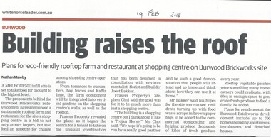
Article, Building Raises The Roof, 2018
... ...burwood highway...burwood east...Whitehorse Historical Society Inc. 2-10 Deep Creek Road Mitcham melbourne brickworks burwood highway burwood east middleborough road eley road restaurants The proponents of the Burwood Brickworks redevelopment have announced a sustainable rooftop farm and restaurant for the site's shopping centre. ...The proponents of the Burwood Brickworks redevelopment have announced a sustainable rooftop farm and restaurant for the site's shopping centre.brickworks, burwood highway, burwood east, middleborough road, eley road, restaurants -
 Whitehorse Historical Society Inc.
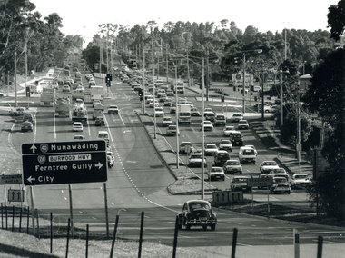
Photograph - B/W Photograph, Springvale Rd. and Burwood Highway intersection, 1999
... burwood highway burwood east...Black and white photograph of the intersection of Burwood Highway and Springvale Rd. East Burwood. Sign on left of photograph. ...Whitehorse Historical Society Inc. 2-10 Deep Creek Road Mitcham melbourne burwood highway burwood east springvale road burwood east Black and white photograph of the intersection of Burwood Highway and Springvale Rd. ...Black and white photograph of the intersection of Burwood Highway and Springvale Rd. East Burwood. Sign on left of photograph. Small black car in foreground.burwood highway burwood east, springvale road burwood east -
 Whitehorse Historical Society Inc.
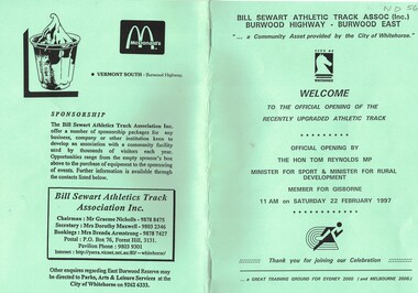
Document - Programme, Bill Sewart Athletic Track, 22/02/1997
... Official opening of the recently upgraded Bill Sewart Athletic Track, Burwood Highway, Burwood East. 22/2/1997. 8 pages....Whitehorse Historical Society Inc. 2-10 Deep Creek Road Mitcham melbourne sewart bill bill sewart athletic track Official opening of the recently upgraded Bill Sewart Athletic Track, Burwood Highway, Burwood East. 22/2/1997. 8 pages. Bill Sewart Athletic Track Document Programme ...Official opening of the recently upgraded Bill Sewart Athletic Track, Burwood Highway, Burwood East. 22/2/1997. 8 pages.sewart bill, bill sewart athletic track -
 Whitehorse Historical Society Inc.
Photograph - Coloured photos x 6, East Burwood Tram East Burwood
... East Burwood Tram Extension...Trams...Burwood Highway...Whitehorse Historical Society Inc. 2-10 Deep Creek Road Mitcham melbourne East Burwood Tram Extension Trams Burwood Highway East Burwood Six photographs of the opening of the East Burwood Tram Extension. ...Six photographs of the opening of the East Burwood Tram Extension.east burwood tram extension, trams, burwood highway east burwood -
Whitehorse Historical Society Inc.
Document, Mini Fun Olympics, 1/05/1988 12:00:00 AM
... Poster to advertise 'Mini Fun Olympics' to be held on Sunday 1 May 1988 from 11 am to 5 pm at the Bill Sewart Athletic Track, East Burwood Reserve, Burwood Highway, East Burwood....Parks and Recreation Department Sports and Recreations Bill Sewart Athletic Track East Burwood Reserve Poster to advertise 'Mini Fun Olympics' to be held on Sunday 1 May 1988 from 11 am to 5 pm at the Bill Sewart Athletic Track, East Burwood Reserve, Burwood Highway, East Burwood. ...Poster to advertise 'Mini Fun Olympics' to be held on Sunday 1 May 1988 from 11 am to 5 pm at the Bill Sewart Athletic Track, East Burwood Reserve, Burwood Highway, East Burwood.Poster to advertise 'Mini Fun Olympics' to be held on Sunday 1 May 1988 from 11 am to 5 pm at the Bill Sewart Athletic Track, East Burwood Reserve, Burwood Highway, East Burwood.Poster to advertise 'Mini Fun Olympics' to be held on Sunday 1 May 1988 from 11 am to 5 pm at the Bill Sewart Athletic Track, East Burwood Reserve, Burwood Highway, East Burwood.city of nunawading. parks and recreation department, sports and recreations, bill sewart athletic track, east burwood reserve -
 Whitehorse Historical Society Inc.
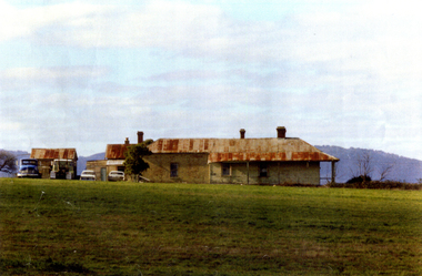
Photograph - Coloured photograph, Mullins Farmhouse East Burwood, 1982
... Coloured photo of Old House in Burwood Highway, East Burwood. West of Springvale Road. ...Whitehorse Historical Society Inc. 2-10 Deep Creek Road Mitcham melbourne orchards Mullens Coloured photo of Old House in Burwood Highway, East Burwood. West of Springvale Road. ...Coloured photo of Old House in Burwood Highway, East Burwood. West of Springvale Road. Mullens Orchard & home. House now demolished.orchards, mullens -
 Whitehorse Historical Society Inc.
Photograph - Coloured Photograph, Mullins House and Orchard East Burwood, 1982
... Coloured photo of Old House on Burwood Highway, East Burwood, since demolished. Home of Mullens Family. ...Whitehorse Historical Society Inc. 2-10 Deep Creek Road Mitcham melbourne peter james centre eastern suburbs geriatric centre Mullens Mullens Family Coloured photo of Old House on Burwood Highway, East Burwood, since demolished. Home of Mullens Family. ...Coloured photo of Old House on Burwood Highway, East Burwood, since demolished. Home of Mullens Family. Now the site of the Eastern Suburbs Geriatric Centre (Peter James Centre).peter james centre, eastern suburbs geriatric centre, mullens, mullens family -
 Melbourne Tram Museum
Album - Robert Thomson Slide Collection - box 16
... Number Date Brief Description Box 16 RT372 23-1-1980 W2 271, High St Kew reconstruction trackwork – route 48 RT373 23-1-1980 W2 504 Burwood Road RT374 23-1-1980 Z7 East Burwood terminus RT375 23-1-1980 Z26 Burwood Highway, route 75 RT376 23-1-1980 W2 255 North Balwyn terminus, route 48 RT377 24-1-1980 W5 at North Coburg terminus – route 19 RT378 24-1-1980 Z37 (route 19) and a W route 20 at North Coburg terminus RT379 24-1-1980 W2 378? ...Number Date Brief Description Box 16 RT372 23-1-1980 W2 271, High St Kew reconstruction trackwork – route 48 RT373 23-1-1980 W2 504 Burwood Road RT374 23-1-1980 Z7 East Burwood terminus RT375 23-1-1980 Z26 Burwood Highway, route 75 RT376 23-1-1980 W2 255 North Balwyn terminus, route 48 RT377 24-1-1980 W5 at North Coburg terminus – route 19 RT378 24-1-1980 Z37 (route 19) and a W route 20 at North Coburg terminus RT379 24-1-1980 W2 378? ...Photo - see pdf file for further information. Number Date Brief Description Box 16 RT372 23-1-1980 W2 271, High St Kew reconstruction trackwork – route 48 RT373 23-1-1980 W2 504 Burwood Road RT374 23-1-1980 Z7 East Burwood terminus RT375 23-1-1980 Z26 Burwood Highway, route 75 RT376 23-1-1980 W2 255 North Balwyn terminus, route 48 RT377 24-1-1980 W5 at North Coburg terminus – route 19 RT378 24-1-1980 Z37 (route 19) and a W route 20 at North Coburg terminus RT379 24-1-1980 W2 378? Park St St Kilda terminus, route 12 RT380 24-1-1980 Z121 route 88 at Bourke St terminus with Spencer St station in background RT381 25-1-1980 Z1 118 and another Z81? At East Preston terminus – both route 88 RT382 26-1-1980 SW5 812 route 67 at Carnegie terminus RT383 28-1-1980 MMTB Austerity bus No. 301 RT384 26-1-1980 SW5 818? And SW6 965 at Carnegie Glen Huntly Road at start of the single line Truganini Road – note the single track signs. Both route 67. RT385 26-1-1980 W2 504 at East Malvern Darling Road – route 3 RT386 26-1-1980 SW5 787 route 52, Mathews Ave. RT387 26-1-1980 SW5 684? Airport West terminus, route 52, RT388 26-1-1980 High St Kew track reconstruction, W6 986, route 48 RT389 26-1-1980 SW6 965 route 67, Glen Huntly Road level crossing RT390 27-1-1980 SW6 962 Collins St route 42 Spencer St terminus RT391 27-1-1980 Z3 121, route 88 Bourke St Mal with parked cars. RT392 27-1-1980 Z3 188? Bourke St route 96 RT393 27-1-1980 3MP tram Camberwell Route 72 at Gardiner level crossing RT394 28-1-1980 MMTB Bus 370, Leyland OPS1 on display RT395 28-1-1980 MAN Bus 103, on display showing Doncaster Depot Demonstrates the work of Robert Thomson in photography, collection and/or production of slidesAssembled album in a black presentation folder of 24 colour slides, collected or produced by Robert Thomson. A list of all photographs with details has been compiled. All rights reserved for all photos., melbourne, tramways, trams, tram 271, high st kew, trackworks, route 48, tram 504, tram 7, east burwood, tram 26, tram 255, north coburg, route 19, tram 37, park st st kilda, tram 121, bourke st, spencer st, tram 118, east preston, route 88, route 12, route 67, carnegie, tram 812, tram 67, buses, tram 965, truganini road, route 3, route 52, tram 787, tram 986, level crossings, glen huntly rd, matthews ave, tram 962, collins st, route 42, tram 188, route 72, gardiner -
 Box Hill Historical Society
Photograph - Burwood Highway
... Box Hill Historical Society Box Hill Heritage Centre Suite 7 Town Hall Hub Box Hill melbourne Burwood Highway looking east; orchards on right hand side of highway Burwood Highway Orchards Roads and streets Photograph Burwood Highway ...Burwood Highway looking east; orchards on right hand side of highwayburwood highway, orchards, roads and streets -
Box Hill Historical Society
Article, Meet your ward councillors, 1986
... East Ward...West Ward...South Ward...Walters> Betty (Cr)...Crawford> Russell (Cr)...Friday> Robin (Cr)...Whitehorse Room...Box Hill Town hall...Anderson> Richard (Cr)...Hargreaves> Tony (Cr)...Medcraft> Greg (Cr)...Buckingham> Ian (Cr)...Thorpe> Tom (Cr)...Tuckett> Philip (Cr)...Electricity Services Centre...Burwood Highway...Burwood...The East and West Wards will meet in the Whitehorse Room at the Town Hall and the West Ward will meet at the Electricity Services Cetre, Burwood Highway, Burwood....Box Hill Historical Society Box Hill Heritage Centre Suite 7 Town Hall Hub Box Hill melbourne City of Box Hill Councillors East Ward West Ward South Ward Walters> Betty (Cr) Crawford> Russell (Cr) Friday> Robin (Cr) Whitehorse Room Box Hill Town hall Anderson> Richard (Cr) Hargreaves> Tony (Cr) Medcraft> Greg (Cr) Buckingham> Ian (Cr) Thorpe> Tom (Cr) Tuckett> Philip (Cr) Electricity Services Centre Burwood Highway Burwood Port> Ian Town Clerks Notice to all residents to meet their Council representatives. ...Notice to all residents to meet their Council representatives. The East and West Wards will meet in the Whitehorse Room at the Town Hall and the West Ward will meet at the Electricity Services Cetre, Burwood Highway, Burwood.city of box hill, councillors, east ward, west ward, south ward, walters> betty (cr), crawford> russell (cr), friday> robin (cr), whitehorse room, box hill town hall, anderson> richard (cr), hargreaves> tony (cr), medcraft> greg (cr), buckingham> ian (cr), thorpe> tom (cr), tuckett> philip (cr), electricity services centre, burwood highway, burwood, port> ian, town clerks -
 Whitehorse Historical Society Inc.
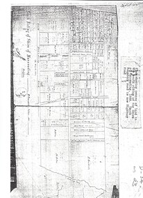
Map, Shire of Nunawading 1888
... burwood east...highbury road...springvale road...mahoneys road...forest hill...holland road...blackburn south...burwood highway...Whitehorse Historical Society Inc. 2-10 Deep Creek Road Mitcham melbourne shire of nunawading. south riding south boundary road burwood east highbury road springvale road mahoneys road forest hill holland road blackburn south burwood highway Plan showing owners of land in the South Riding of the Shire of Nunawading, 1888. ...Plan showing owners of land in the South Riding of the Shire of Nunawading, 1888. South Boundary Road is now Highbury Road.shire of nunawading. south riding, south boundary road, burwood east, highbury road, springvale road, mahoneys road, forest hill, holland road, blackburn south, burwood highway