Showing 628 items matching "business park"
-
 Whitehorse Historical Society Inc.
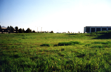
Photograph - Colour Photograph, Tally Ho Business Park 2003
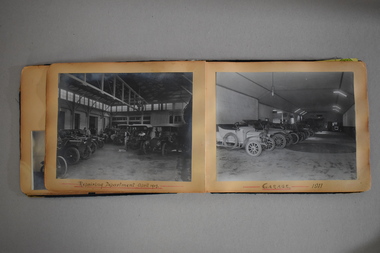
... Tally Ho Business Park 2003......Business Park...Tally Ho Business Park was developed by Land Lease, commencing in 1988, and then CGA Bryson from the late 1990's. ...Coloured photograph of Tally Ho Business Park in the early stages, looking north towards Burwood Highway....It closed in 1986. Tally Ho Business Park 2003 Coloured photograph of Tally Ho Business Park in the early stages, looking north towards Burwood Highway. ...Tally Ho Business Park was developed by Land Lease, commencing in 1988, and then CGA Bryson from the late 1990's. It was completed in 2002. The land on which it stands was previously the site of the Tally Ho Boys Home. This home was run, from 1903-1986 by the Wesley Central Mission, which caters for boys from the slums. It closed in 1986.Coloured photograph of Tally Ho Business Park in the early stages, looking north towards Burwood Highway.tally ho, business park, 2003 -
 Whitehorse Historical Society Inc.
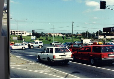
Photograph - Colour Photograph, Springvale Road East Burwood
... Tally Ho Business Park...The Tally Ho Business Park was built on vacant land previously owned by the Methodist Church. ...First stages of the Tally Ho Business Park in the background....Whitehorse Historical Society Inc. 2-10 Deep Creek Road Mitcham melbourne The Tally Ho Business Park was built on vacant land previously owned by the Methodist Church. ...The Tally Ho Business Park was built on vacant land previously owned by the Methodist Church. The land was sold cheaply to the Church by Abel Hoadley, and the Tally Ho Boys Home was erected there. A change in the care of the boys meant that the land became vacant for a considerable time before buildings appeared. The Country Fire Authority, Vic Roads and World Vision are also located there.4 coloured photographs (a-d) taken at the intersection of Springvale Road & Burwood Hwy East Burwood. First stages of the Tally Ho Business Park in the background.tally ho business park, businesses -
 Flagstaff Hill Maritime Museum and Village
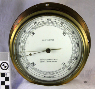
Instrument - Barometer, 1952
... 8 Neptune Court Orion Business Park, Tyneside , North Shields, England UK ...Mr John Wilson Gillie was born on the 31st of March 1864. On the 31st of July 1880 he was apprenticed for four years to J.J. Wilson and Sons, Nautical Instrument Makers of Sunderland. Following the apprenticeship he spent six months to a year as an ‘improver’ in Glasgow, and then started a new company ‘Wilson and Gillie’ in North Shields. At this time sail had just given way to steam and wooden ships to steel, and the railways were competing with colliers for the carrying of coal from the North East of England to London and the South. In 1858 only seven out of 44 shipyards on the Tyne were using iron, but by 1862 there were ten, employing around 4,000 men. These changes had a significant effect on nautical instrument manufacturers, as the magnetic compass for a wooden sailing vessel was very simple and required little in the way of compensation. For steel vessels much more was required and this was a period of great development, both in the compass bowl and the binnacle in which it was housed. In 1870 Sir William Thomson (later Lord Kelvin) designed his dry card standard compass, which completely replaced all previous designs. Wilson and Gillie started as agents for the Thomson compass, but later J.W. Gillie, using similar principles, redesigned the compass suspension and patented the ‘UNIT’ standard compass. It became popular with local shipowners and shipbuilders. In 1910 the firm of John Lilley and Son (which had been established in London in 1812), found themselves in financial difficulties and were saved with the help of John Wilson Gillie, who established, on the 8th of August 1911, a new firm of John Lilley and Son Limited. John Lilley and Son had been the sole London agents for Sir William Thomson, a very enviable position during this period, when the Thomson compass led the field. Unfortunately, Mr. Lilley had quarreled with the Glasgow company, who withdrew the agency and established their own branch in London (later to become Kelvin White and Hutton). On November 7th 1913, the firm of John Lilley and Son Limited of London amalgamated with Wilson and Gillie of North Shields, and after this date instruments manufactured by the two companies bore the name John Lilley and Son Limited of London and North Shields. During the 1930s many of the London nautical instrument makers were in difficulties, including John Lilley and Son Limited and Reynolds and Son, Dobbie and Clyde Limited, and Mr. J.W. Gillie arranged an amalgamation between these two companies. The new firm became Lilley and Reynolds Limited. In 1943, with estate duties in mind, the North Shields company was reconstituted and took the name of John Lilley and Gillie Limited, although the shareholders, directors and personnel remained unchanged In the early 1970s Lilley and Gillie developed close links with Observator in Rotterdam, who manufactured one of the first fully reliable transmitting magnetic compass systems. The Observator shareholders, Holland America Line, bought the share capital of John Lilley and Gillie Limited., but retained all the personnel and the directors. Tug Melbourne: The barometer was salvaged from a 496-ton tug that had been built in 1952 and had sunk in Port Philip Bay on the 9th of August 1972 after a collision with the SS Nieuw Holland, in 1973 it had been raised and scraped at this time the barometer was salvaged. The tug had been renamed from the Howard Smith to the “Melbourne” after the Adelaide Steamship Co was taken over by Howard Smith& Co, who were heavily involved in towage, salvage and the stevedoring industries in 1961.The significance is that the item was on a vessel that was evolved in a serious collision in Port Philip Bay in 1972. It is linked with the activities of the Port at that time and helps to form a picture of what the maritime industries that operated from Port Melbourne were like and the activities that stevedore and towage companies underwent.Ship Barometer, in brass caseInscribed "Compensated" , "John Lilley & Gillie Ltd London & North Shields." and "Millibars".flagstaff hill, warrnambool, shipwrecked coast, flagstaff hill maritime museum, maritime museum, shipwreck coast, flagstaff hill maritime village, great ocean road, barometer, ship's barometer, weather instrument, john lilley & gillie ltd, shipwreck artefact, the tigboat melbourne, north shields, howard smith, the melbourne, salvage -
 Whitehorse Historical Society Inc.
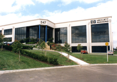
Photograph - Coloured Photograph, Hewlett Packard
... tally ho business park...It is located in the Tally Ho Business Park in East Burwood. The number 347 is prominent as is the Hewlett Packard sign on the right,...It is located in the Tally Ho Business Park in East Burwood. The number 347 is prominent as is the Hewlett Packard sign on the right, Hewlett Packard Photograph Coloured Photograph ...Hewlett Packard are particularly proud of the use of glass in their building, and its solar qualities. They produce printers, computers, scanners and digital photographic equipment etc2 coloured photographs (a+b) of the Victorian Headquarters of Hewlett Packard in East Burwood. It is located in the Tally Ho Business Park in East Burwood. The number 347 is prominent as is the Hewlett Packard sign on the right,tally ho business park, east burwood, hewlett packard -
 Whitehorse Historical Society Inc.
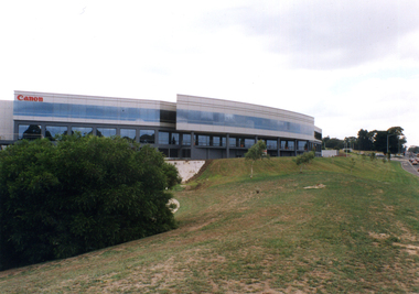
Photograph - Colour Photograph, Canon Offices Tally Ho
... tally ho business park...Three coloured photographs of the Canon office in Tally Ho Business Park, which is on the corner of Burwood Highway and Springvale Road. ...Canon makes cameras, lenses, printers, scanners, video-cameras, photo copiers and so on. tally ho business park east burwood canon pty ltd Three coloured photographs of the Canon office in Tally Ho Business Park, which is on the corner of Burwood Highway and Springvale Road. ...The East Burwood Canon building is at 33 Lakeside Drive, Burwood East. Canon makes cameras, lenses, printers, scanners, video-cameras, photo copiers and so on.Three coloured photographs of the Canon office in Tally Ho Business Park, which is on the corner of Burwood Highway and Springvale Road. One photo shows the western side of the Canon building (with the pond), one shows the curved southern side, and one shows the building looking east from Springvale Road.tally ho business park, east burwood, canon pty ltd -
 Whitehorse Historical Society Inc.
Mixed media - Living, investing, growing, Whitehorse City
... ...Tally Ho Business Park...Shows aspects of city - Gordon Crescent, Blackburn Lake, Schools, Tally Ho Business Park, major businesses and retailers, Bruce Thompson Managing Director, Hewlett Packard, Simon Ho, Hong Kong Bank, Felicity Mason Lend Lease, Maroondah Transport corridor, Forest Hill Chase, Sport, Box Hill Community Art Space, Alan Stockdale, Treasurer, Victoria....Shows aspects of city - Gordon Crescent, Blackburn Lake, Schools, Tally Ho Business Park, major businesses and retailers, Bruce Thompson Managing Director, Hewlett Packard, Simon Ho, Hong Kong Bank, Felicity Mason Lend Lease, Maroondah Transport corridor, Forest Hill Chase, Sport, Box Hill Community Art Space, Alan Stockdale, Treasurer, Victoria. ...Video - Living, Investing, Growing - Produced by City o Whitehorse, Opening words by Chief Commissioner, Geoff Oscar 1995. Shows aspects of city - Gordon Crescent, Blackburn Lake, Schools, Tally Ho Business Park, major businesses and retailers, Bruce Thompson Managing Director, Hewlett Packard, Simon Ho, Hong Kong Bank, Felicity Mason Lend Lease, Maroondah Transport corridor, Forest Hill Chase, Sport, Box Hill Community Art Space, Alan Stockdale, Treasurer, Victoria.oscar geoff - chief commissioner, gordon crescent blackburn, maroondah transport corridor, blackburn lake, forest hill chase, box hill community art space, tally ho business park, alan stockdale - treasurer of victoria, bruce thjompson - managing director hewlett packard, ho simon hong kong bank, city of whitehorse mason felicity lend lease -
 Whitehorse Historical Society Inc.
Document, AGFA, 28/01/2026
... ...Greenwood Business Park...In 2007 AGFA relocated to new facilities in the Greenwood Business Park at 301 Burwood Highway, Burwood on the corner of Burwood Highway and Station Street, Burwood....AGFA Potocnik Alexander J Tunstall Park Greenwood Business Park Burwood Highway No 301 Burwood Research on AGFA by Dr. ...Research on AGFA by Dr. Alexander J. PotocnikA$ x 6 pagesnon-fictionResearch on AGFA by Dr. Alexander J. Potocnikagfa, potocnik alexander j, tunstall park, greenwood business park, burwood highway no 301 burwood -
 Sunshine and District Historical Society Incorporated
Administrative record - City of Sunshine - Commissioner Mr Alexander Alex George Gillon Collection 1976 - 1982 - Extraordinary Business Report Selwyn Park Change Rooms 22nd June 1982, City of Sunshine, 22June 1982
... City of Sunshine - Commissioner Mr Alexander Alex George Gillon Collection 1976 - 1982 - Extraordinary Business Report Selwyn Park Change Rooms 22nd June 1982...Park Change Room Facilities Report Foolscap sized document. Administrative record City of Sunshine - Commissioner Mr Alexander Alex George Gillon Collection 1976 - 1982 - Extraordinary Business Report Selwyn Park Change Rooms 22nd June 1982 City of Sunshine ...Selwyn Park Change Room Facilities Report city of sunshine, alexander "alex" george gillon, selwyn park, selwyn street, albion -
 Charlton Golden Grains Museum Inc
Photograph, Wright, Win, Front of Charlton Foundry 1963, c.1963
... Alf and Ted Dabron and a dog sitting outside their business. Parked car on RH side of photo....Alf and Ted Dabron and a dog sitting outside their business. Parked car on RH side of photo. Front of Charlton Foundry 1963 Photograph Photograph Wright, Win Dabron, Alf Dabron, Ted ...Charlton Foundry established 1885 by C. Munro, owned and operated by the Dabrons 1899 - 1965.Black & white photograph of the front of the Charlton Foundry. Alf and Ted Dabron and a dog sitting outside their business. Parked car on RH side of photo.The Charlton Foundry, Dabron Bros and Terry. Taken by Win Wright 1963munro, charlton, business, industry, foundry -
 Whitehorse Historical Society Inc.
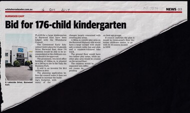
Article, Bid For 176-Child Kindergarten, 2017
... ...Tally Ho Business Park...Burwood East Kindergarten Kindergartens Lakeside Drive Burwood East City of Whitehorse Tally Ho Business Park East Burwood Plans for a 176-child Kindergarten in East Burwood have been lodged with the Whitehorse Council. ...Plans for a 176-child Kindergarten in East Burwood have been lodged with the Whitehorse Council. By the Greenwood Early Education Centre for 6 Lakeside Drive, Burwood East.Plans for a 176-child Kindergarten in East Burwood have been lodged with the Whitehorse Council by the Greenwood Early Education Centre for 6 Lakeside Drive, Burwood East.Plans for a 176-child Kindergarten in East Burwood have been lodged with the Whitehorse Council. By the Greenwood Early Education Centre for 6 Lakeside Drive, Burwood East.burwood east, kindergarten, kindergartens, lakeside drive, burwood east, city of whitehorse, tally ho business park, east, burwood -
 Eltham District Historical Society Inc
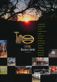
Book, Bush Telegraph Colour Business Guide 2003, 2003
... business directory...chirnside park...Soft cover book of colour display advertisements for business's located in Chirnside Park, Doncaster East, Donvale, Kangaroo Ground, Lilydale, Nth Croydon, Nth Eltham, Nth Ringwood, Park Orchards, Research, Templestowe, Warrandyte, Warranwood and Wonga Park areas arranged by category as listed in the contents page. ...This edition has broadened the demographic to include 14 suburbs. business directory chirnside park doncaster east donvale kangaroo ground lilydale nth croydon nth eltham nth ringwood north eltham park orchards research (vic.) templestowe warrandyte warranwood wonga park Soft cover book of colour display advertisements for business's located in Chirnside Park, Doncaster East, Donvale, Kangaroo Ground, Lilydale, Nth Croydon, Nth Eltham, Nth Ringwood, Park Orchards, Research, Templestowe, Warrandyte, Warranwood and Wonga Park areas arranged by category as listed in the contents page. ...Second publication following the success of the 2002 edition, aims to provide the local community with a comprehensive resource, promoting local businesses and services. This edition has broadened the demographic to include 14 suburbs.Soft cover book of colour display advertisements for business's located in Chirnside Park, Doncaster East, Donvale, Kangaroo Ground, Lilydale, Nth Croydon, Nth Eltham, Nth Ringwood, Park Orchards, Research, Templestowe, Warrandyte, Warranwood and Wonga Park areas arranged by category as listed in the contents page. Includes a sprinkling of historical images and brief descriptions of each area. Also includes lists of Child care, Churches, coming events and schools. 63 pagesbusiness directory, chirnside park, doncaster east, donvale, kangaroo ground, lilydale, nth croydon, nth eltham, nth ringwood, north eltham, park orchards, research (vic.), templestowe, warrandyte, warranwood, wonga park -
 Sunshine and District Historical Society Incorporated
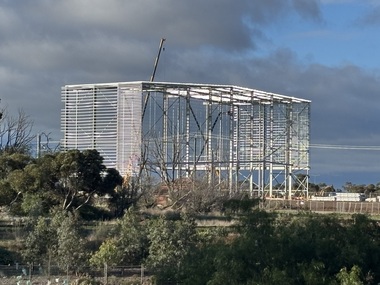
Archive - Asahi Beverages National Distribution Centre 179 Tilburn Road Deer Park, John Alchin, 3rd June 2026
... The former ICI / Orica site of 330,000 m² is being converted into an industrial & logistics business park by UniSuper / GPT / HB+B Property. ...The former ICI / Orica site of 330,000 m² is being converted into an industrial & logistics business park by UniSuper / GPT / HB+B Property. ...The former ICI / Orica site of 330,000 m² is being converted into an industrial & logistics business park by UniSuper / GPT / HB+B Property. UniSuper purchased the 66 hectares of Orica’s surplus land in February 2024Asahi is the first major tenant of this new industrial & logistics business park.5887.01 - Asahi Beverages National Distribution Centre 179 Tilburn Road Deer Park Page 1 5887.01 - Asahi Beverages National Distribution Centre 179 Tilburn Road Deer Park Page 2.jpg 5887.01 - Asahi Beverages National Distribution Centre 179 Tilburn Road Deer Park Page 3.jpg 5887.01 - Asahi Beverages National Distribution Centre 179 Tilburn Road Deer Park.docx 5887.02 - Asahi Beverages National Distribution Centre 179 Tilburn Road Deer Park Building Works 3rd June 2026.jpeg 5887.03 - Asahi Beverages National Distribution Centre Building 179 Tilburn Road Deer Park Works 3rd June 2026.jpeg 5887.04- Asahi Beverages National Distribution Centre 179 Tilburn Road Deer Park Building Works 24th June 2026.jpeg 5887.05- Asahi Beverages National Distribution Centre 179 Tilburn Road Deer Park Building Works 24th June 2026.jpeg 5887.06- Asahi Beverages National Distribution Centre 179 Tilburn Road Deer Park Building Works 9th July 2026.jpeg 5887.07- Asahi Beverages National Distribution Centre 179 Tilburn Road Deer Park Building Works 9th July 2026.jpegasahi beverages, tilburn road, deer park -
 Ballarat Heritage Services
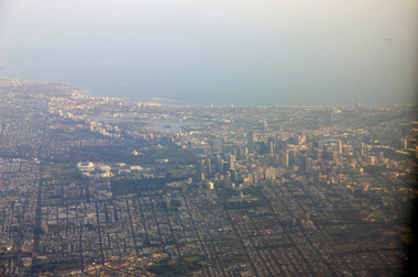
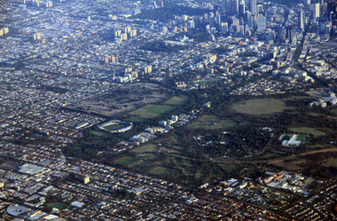
Photograph - Digital Photograph, L.J. Gervasoni, Melbourne CBD and Albert Park Lake on approach Melbourne Airport, 2016
... Digital Image showing an aerial view of the Melbourne Central Business District and Albert Park....Ballarat Heritage Services PO Box 2209 Bakery Hill Post Office goldfields aerial melbourne yarra river cbd albert park lake port phillip bay Digital Image showing an aerial view of the Melbourne Central Business District and Albert Park. ...Digital Image showing an aerial view of the Melbourne Central Business District and Albert Park.aerial, melbourne, yarra river, cbd, albert park, lake, port phillip bay -
 Ballarat Heritage Services
Digital Photograph, L.J. Gervasoni, Royal Park CBD and zoo from the air, 2016
... Digital Image showing an aerial view of the Melbourne Central Business District and Royal Park....Ballarat Heritage Services PO Box 2209 Bakery Hill Post Office goldfields aerial melbourne yarra river cbd royal park zoo Digital Image showing an aerial view of the Melbourne Central Business District and Royal Park. ...Digital Image showing an aerial view of the Melbourne Central Business District and Royal Park.aerial, melbourne, yarra river, cbd, royal park, zoo -
 Ballarat Heritage Services
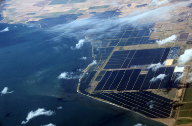
Digital Photograph, L.J. Gervasoni, werribee farm from the air, 2016
... Digital Image showing an aerial view of the Melbourne Central Business District and Royal Park....Ballarat Heritage Services PO Box 2209 Bakery Hill Post Office goldfields aerial melbourne Werribee Farm sewerage Digital Image showing an aerial view of the Melbourne Central Business District and Royal Park. werribee farm from the air Digital Photograph L.J. ...Digital Image showing an aerial view of the Melbourne Central Business District and Royal Park.aerial, melbourne, werribee farm, sewerage -
Glenelg Shire Council Cultural Collection
Booklet, Commissioned by Portland Tourist Association Inc, 'Portland Victoria's Birth Place Welcome to Living History', n.d
... Book contains information on Portland, plus National Parks, reacreation, business advertisments....Book contains information on Portland, plus National Parks, reacreation, business advertisments. 'Portland Victoria's Birth Place Welcome to Living History' Booklet Booklet Commissioned by Portland Tourist Association Inc ...Bowerbird MuseumPromotional booklet for Portland and District. Heavy paper covers, green with coloured photos of Portland and district. 44 page booklet, white with black print. Map of Portland and District in centre. Book contains information on Portland, plus National Parks, reacreation, business advertisments. -
 Melbourne Tram Museum
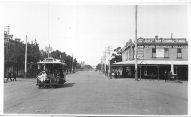
Postcard - Bridport St Albert Park - Cable tram
... Park with the destination of South Melbourne at the corner of Montague St. In the background are the level crossing with the gates closed, J Bolday? Chemist, and London House, advertising Toms's business...Park with the destination of South Melbourne at the corner of Montague St. In the background are the level crossing with the gates closed, J Bolday? Chemist, and London House, advertising Toms's business ...The photograph shows a cable tram in Bridport St Albert Park with the destination of South Melbourne at the corner of Montague St. In the background are the level crossing with the gates closed, J Bolday? Chemist, and London House, advertising Toms's business college, Albert Park Grammar school. London A Marshall Hotel with an Abbot's lager sign. In front of this building is a drinking fountain or a memorial. Second copy has the title "Rose Series P.3409 Bridport Street, Albert Park Vic"Yields information about cable trams in Bridport St Albert Park.Black and White Photograph postcard format with note on rear. Two copies held.In pencil on the rear "Bridport St Albert Park"tramways, trams, cable tram, bridport st, montague st, albert park, rose series -
 Sunshine and District Historical Society Incorporated
Archive - Royal Australian Air Force RAAF and Tottenham No 1 Stores Depot
... Booklet The Conferring of The Freedom of Entry to the City of Sunshine upon the First Try City of Sunshine Regional Cadet Unit 16 May 1987|Booklet 50th Anniversay RAAF Stores Depot 1939 to 1989|Typed Notes Royal Australian Air force in the Second World War|Brochure Central West Business Park Ashley Street Ex RAAF site|Newspaper Article Western Independent 8 June 1993 Sabre is over and out|Flyer Royal Australian Air Force No 1 Stores depot Closure Events 22 April|Booklet A Short history of No 1 Stores Depot|Flyer The Story of the B24 Liberator Memorial Restoration fund Incorporated|Booklet Freedom of Entry to the City of Sunshine by No 1 Stores Depot RAAF 26 May 1993|Booklet No 1 Stores Depot RAAF Tottenham Closure Parade 28 May 1993|Newspaper Article Western Independent 11 May 1993 A stylish farewell|Booklet RAAF Point Cook Historic Air Display 75 years of service 1913 to 1988|Booklet The RAAF in Victoria Training Command published to commemorate the 70th Anniversary of the RAAF 1921 to 1994|Booklet RAAF Beating the Retreat Shrine of Remembrance 31 March 1993|Booklet RAAF Store Depot Hawker Siddeley Trophy|Booklet RAAF A Valedictory Service of Thanksgiving for 54 years service by No 1 Stores Depot 1939 to 1993 at the chapel of the Holy Trinity RAAF Point Cook 24 May 1993|Booklet Freedom of Entry to the City of Sunshine upon No 1 Stores Depot RAAF 27 March 1974|Booket RAAF Store Depot 1939 to 1993 Closure Dining In 22 April 1993|Booklet Freedom of Entry to the City of Sunshine upon No 1 Stores Depot RAAF 18 November 1989|Booklet RAAF No 1 Stores depot Closure Ball Souther Cross Hotel Melbourne 28 May 1993|Invitation to Mr J Willaton RAAF No 1 Stores depot Closure Ball Souther Cross Hotel Melbourne 28 May 1993|Typed Report No 1 Stores Depot History|Map Tottenham RAAF 1SD Master Plan|Photographs of RAAF marching down middle of Hampshire Road Sunshine|Typed Report Introduction to Stores Depots Murray Moore 4 July 1995|Newspaper Article Sunraysia Daily 9 September 1994 Down memory lane at tottenham|Newspaper Article The Advocate 19 March 1993 RAAF prepares to close base|Newspaper Article The Advocate 3 June 1992 RAAF stores move out|Newspaper Article Western Independent 11 May 1983 Tottenham Stoes Depot...Air Force Booklet The Conferring of The Freedom of Entry to the City of Sunshine upon the First Try City of Sunshine Regional Cadet Unit 16 May 1987|Booklet 50th Anniversay RAAF Stores Depot 1939 to 1989|Typed Notes Royal Australian Air force in the Second World War|Brochure Central West Business Park Ashley Street Ex RAAF site|Newspaper Article Western Independent 8 June 1993 Sabre is over and out|Flyer Royal Australian Air Force No 1 Stores depot Closure Events 22 April|Booklet A Short history of No 1 Stores Depot|Flyer The Story of the B24 Liberator Memorial Restoration fund Incorporated|Booklet Freedom of Entry to the City of Sunshine by No 1 Stores Depot RAAF 26 May 1993|Booklet No 1 Stores Depot RAAF Tottenham Closure Parade 28 May 1993|Newspaper Article Western Independent 11 May 1993 A stylish farewell|Booklet RAAF Point Cook Historic Air Display 75 years of service 1913 to 1988|Booklet The RAAF in Victoria Training Command published to commemorate the 70th Anniversary of the RAAF 1921 to 1994|Booklet RAAF Beating the Retreat Shrine of Remembrance 31 March 1993|Booklet RAAF Store Depot Hawker Siddeley Trophy|Booklet RAAF A Valedictory Service of Thanksgiving for 54 years service by No 1 Stores Depot 1939 to 1993 at the chapel of the Holy Trinity RAAF Point Cook 24 May 1993|Booklet Freedom of Entry to the City of Sunshine upon No 1 Stores Depot RAAF 27 March 1974|Booket RAAF Store Depot 1939 to 1993 Closure Dining In 22 April 1993|Booklet Freedom of Entry to the City of Sunshine upon No 1 Stores Depot RAAF 18 November 1989|Booklet RAAF No 1 Stores depot Closure Ball Souther Cross Hotel Melbourne 28 May 1993|Invitation to Mr J Willaton RAAF No 1 Stores depot Closure Ball Souther Cross Hotel Melbourne 28 May 1993|Typed Report No 1 Stores Depot History|Map Tottenham RAAF 1SD Master Plan|Photographs of RAAF marching down middle of Hampshire Road Sunshine|Typed Report Introduction to Stores Depots Murray Moore 4 July 1995|Newspaper Article Sunraysia Daily 9 September 1994 Down memory lane at tottenham|Newspaper Article The Advocate 19 March 1993 RAAF prepares to close base|Newspaper Article The Advocate 3 June 1992 RAAF stores move out|Newspaper Article Western Independent 11 May 1983 Tottenham Stoes Depot Collection of articles on the Royal Australian Air Force RAAF and Tottenham No 1 Stores Depot Archive Royal Australian Air Force RAAF and Tottenham No 1 Stores Depot ...Booklet The Conferring of The Freedom of Entry to the City of Sunshine upon the First Try City of Sunshine Regional Cadet Unit 16 May 1987|Booklet 50th Anniversay RAAF Stores Depot 1939 to 1989|Typed Notes Royal Australian Air force in the Second World War|Brochure Central West Business Park Ashley Street Ex RAAF site|Newspaper Article Western Independent 8 June 1993 Sabre is over and out|Flyer Royal Australian Air Force No 1 Stores depot Closure Events 22 April|Booklet A Short history of No 1 Stores Depot|Flyer The Story of the B24 Liberator Memorial Restoration fund Incorporated|Booklet Freedom of Entry to the City of Sunshine by No 1 Stores Depot RAAF 26 May 1993|Booklet No 1 Stores Depot RAAF Tottenham Closure Parade 28 May 1993|Newspaper Article Western Independent 11 May 1993 A stylish farewell|Booklet RAAF Point Cook Historic Air Display 75 years of service 1913 to 1988|Booklet The RAAF in Victoria Training Command published to commemorate the 70th Anniversary of the RAAF 1921 to 1994|Booklet RAAF Beating the Retreat Shrine of Remembrance 31 March 1993|Booklet RAAF Store Depot Hawker Siddeley Trophy|Booklet RAAF A Valedictory Service of Thanksgiving for 54 years service by No 1 Stores Depot 1939 to 1993 at the chapel of the Holy Trinity RAAF Point Cook 24 May 1993|Booklet Freedom of Entry to the City of Sunshine upon No 1 Stores Depot RAAF 27 March 1974|Booket RAAF Store Depot 1939 to 1993 Closure Dining In 22 April 1993|Booklet Freedom of Entry to the City of Sunshine upon No 1 Stores Depot RAAF 18 November 1989|Booklet RAAF No 1 Stores depot Closure Ball Souther Cross Hotel Melbourne 28 May 1993|Invitation to Mr J Willaton RAAF No 1 Stores depot Closure Ball Souther Cross Hotel Melbourne 28 May 1993|Typed Report No 1 Stores Depot History|Map Tottenham RAAF 1SD Master Plan|Photographs of RAAF marching down middle of Hampshire Road Sunshine|Typed Report Introduction to Stores Depots Murray Moore 4 July 1995|Newspaper Article Sunraysia Daily 9 September 1994 Down memory lane at tottenham|Newspaper Article The Advocate 19 March 1993 RAAF prepares to close base|Newspaper Article The Advocate 3 June 1992 RAAF stores move out|Newspaper Article Western Independent 11 May 1983 Tottenham Stoes Depotair force -
 Eltham District Historical Society Inc
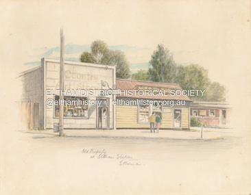
Artwork, other - Sketch, E. Foreman, Old property at Eltham Station, c.1980
... During the course of their business a number of craft shops and galleries opened and closed in Eltham. One such shop was Bimbadeen, next to Ansell and Muir's chicken shop opposite Eltham Lower Park. ...During the course of their business a number of craft shops and galleries opened and closed in Eltham. One such shop was Bimbadeen, next to Ansell and Muir's chicken shop opposite Eltham Lower Park. ...Situated at 965 Main Road adjacent to the Eltham Railway Station, the Country Art Store was originally a hairdresser and Tattersalls agency In 1968 Pam Robinson and Caroline Shenton opened a small shop on the corner of Main Road and Napoleon Street. Four months later a damaged fire hyrdant flooded the store and ruined all their stock. The pair moved to the former hardresser shop at 965 Main Road, adjacent to the Eltham Railway Station, opposite the Stationmaster's house and opened the Country Art Store and adjacent gallery. At the time the only other shop selling pottery was the Potters Cottage in Warrandyte. During the 1970s the gallery was the Wiregrass Gallery. In 1993, after 25 years operating the Country Art Store, the pair decided to sell up and move to warmer climates. During the course of their business a number of craft shops and galleries opened and closed in Eltham. One such shop was Bimbadeen, next to Ansell and Muir's chicken shop opposite Eltham Lower Park. That business run by Don Brown, then a local artist was taken over as River Clay run by Leo Haanappel and Coeny Dommers but ultimately sat in a flood plain and was demolished. When the Country Art Store became available in 1993, Leo Haanappel and Coeny Dommers took it over. The premises became Platform 3095 cafe around 2015.Old Property at Eltha Station E. Foremanart store, country art store, country art store (eltham), eltham railway station, platform 3095, restaurants, shops, wiregrass gallery -
 Eltham District Historical Society Inc
Photograph - Digital Photograph, Marguerite Marshall, Eltham Lower Park, 20 April 2008
... The park also attracted picnic parties and campers from the inner suburbs as did Wingrove Park, and businesses catering for visitors, sprang up on the opposite side of Main Road. ...The park also attracted picnic parties and campers from the inner suburbs as did Wingrove Park, and businesses catering for visitors, sprang up on the opposite side of Main Road. ...Originally a race course, the park has brought the community together with a variety of activities. Published: Nillumbik Now and Then / Marguerite Marshall 2008; photographs Alan King with Marguerite Marshall.; p45 Once used for horse racing, which attracted visitors from Melbourne, the Eltham Lower Park has brought the community together with a wide range of activities. Horse riding is now enjoyed as a recreation in the park as are other sports. The park also includes the Diamond Valley Railway miniature trains and a sanctuary for the rare and vulnerable Eltham Copper Butterfly. Eltham Lower Park, with other parks, forms an almost continuous green band from Eltham’s centre, along the Diamond Creek to the Yarra River.1 Before European settlement the Wurundjeri people met on this land, particularly at the junction of the Diamond Creek with the Yarra River, which they called Birr-arung. This is commemorated by the sculpture, Not just a Pretty Place by Aleks Danko, winner of the 2000 Nillumbik Art in Public Places Award. The first European to settle here was probably Henry Foley, who in 1841 used it as part of his pastoral run. Foley sold his leasehold to Joseph Wilson in 1845, who soon after sold it to Frederick Falkiner. During the 1840s the future park was part of a government square mile (2.6 sqkm) reserve, north of the Yarra, within the Parish of Nillumbik, later named Eltham. Soon the land was used for horse racing after nearby residents cleared ten acres (4ha) in the early 1850s. A three-quarter of a mile (1.2km) race secured the winner the £10 Publican’s Prize. In response to popular demand, the newly formed Eltham District Road Board petitioned the Surveyor General of the Colony of Victoria, in 1856, for 36 acres (14.6ha) of crown land for a racecourse and recreation. By 1858 the Eltham races had become an institution. ‘Many skirmishes occurred and the way home was paved with temptation, with sly-grog for sale.3 In the early 1870s, two jockeys were sons of the police officer in charge of the Eltham Police Station, Miles S Lyons. Another ten acres (4ha) was added to the area in 1866 and 12 acres (4.8ha) – Hohnes Hill – in 1870. In 1866, two acres (0.8ha) on the creek banks became an animal pound with William Walsh the pound keeper in 1870, but this was later incorporated into the park. By 1877 the area was called a public park but horse racing and training continued into the 1920s. In the mid-1900s trotters were trained on a circuit road. In 1953 the Eltham Pony Club was established and used a cross-country course on Hohnes Hill. From the mid 1950s the club held the Eltham Easter Fair at the park, later to include a procession along Main Road from the town centre to the park. The park also attracted picnic parties and campers from the inner suburbs as did Wingrove Park, and businesses catering for visitors, sprang up on the opposite side of Main Road. Bus-loads of school children visited the park for Gould League bird days in the 1960s. In 1979 the Eltham Shire Council bought Lenister Farm, linking the park with the Yarra River. The Lenister Farm wetland includes a bird hide, viewing platform and interpretive signs.5 Pioneer Henry Stooke, later Road Board chairman, bought the 11 acres (4.5ha) - later to become Lenister Farm - from the Crown in 1862. Stooke never lived on this site and the two houses at Lenister Farm were built in the 20th century. Since its formation in 1871, the Council has controlled this crown land, which it named Eltham Park. But in the 1920s Eltham Council bought land near the town centre for a park, which it named Eltham Central Park. To avoid confusion the Council renamed Eltham Park, Eltham Lower Park. Since 2004 the Yarra footbridge has linked the park with the Yarra Valley Metropolitan Park and the Main Yarra Trail.This collection of almost 130 photos about places and people within the Shire of Nillumbik, an urban and rural municipality in Melbourne's north, contributes to an understanding of the history of the Shire. Published in 2008 immediately prior to the Black Saturday bushfires of February 7, 2009, it documents sites that were impacted, and in some cases destroyed by the fires. It includes photographs taken especially for the publication, creating a unique time capsule representing the Shire in the early 21st century. It remains the most recent comprehenesive publication devoted to the Shire's history connecting local residents to the past. nillumbik now and then (marshall-king) collection, eltham lower park, eltham park -
 Warrnambool and District Historical Society Inc.
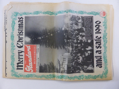
Document, Newspaper: Warrnambool Standard Christmas 1989, 1989
... The Holiday Guide section has articles on the Moscow Circus, Robert Ullmann, Lake Pertobe playground, local national parks, The film Quigley Down Under and points of interest along the coast. An interesting walk back through time and an interesting record of events and advertisements for businesses at the time. warrnambool, warrnambool standard warrnambool standard december 1989 Saturday December 23 1989. ...This newspaper holds a collection of usual articles from local and national news,sports news to letters to the editor, advertisements and a supplement on activities for the holiday period. It contains the local advertisements for houses. The Holiday Guide section has articles on the Moscow Circus, Robert Ullmann, Lake Pertobe playground, local national parks, The film Quigley Down Under and points of interest along the coast. An interesting walk back through time and an interesting record of events and advertisements for businesses at the time.Front page has green holly border with photograph of Carols by Candlelight on the Civic Green. Banner headlines are in black.Back cover has a Christmas poem printed in black on pink background. Green holly border.44 pagesSaturday December 23 1989.warrnambool,, warrnambool standard, warrnambool standard december 1989 -
 Warrnambool and District Historical Society Inc.
Map - Tourist Map Collection: Warrnambool & District Tourist Maps, Philprint, Warrnambool
... It appears to not have been commercially printed and includes details of attractions no longer operating in Warrnambool such as Warrnambool Aquarium and the Oasis Reptile Park and Zoo. [.2] Commercially printed Warrnambool tourist map (c mid 1980's) surrounded by advertisements for local businesses. [.3] Commercial printed December 1991 tourist map of Warrnambool and District includes a competition entry form [.4] Commercially printed tourist map aimed at children [.5] Walking map of Warrnambool and District [.6] Commercially printed Warrnambool tourist map (c mid 1980's) surrounded by advertisements for local businesses. ...It appears to not have been commercially printed and includes details of attractions no longer operating in Warrnambool such as Warrnambool Aquarium and the Oasis Reptile Park and Zoo. [.2] Commercially printed Warrnambool tourist map (c mid 1980's) surrounded by advertisements for local businesses. [.3] Commercial printed December 1991 tourist map of Warrnambool and District includes a competition entry form [.4] Commercially printed tourist map aimed at children [.5] Walking map of Warrnambool and District [.6] Commercially printed Warrnambool tourist map (c mid 1980's) surrounded by advertisements for local businesses. ...This is a diverse collection of Tourist Maps for the Warrnambool & District area. [.1] From information on this guide it dates from the mid 1970's. It appears to not have been commercially printed and includes details of attractions no longer operating in Warrnambool such as Warrnambool Aquarium and the Oasis Reptile Park and Zoo. [.2] Commercially printed Warrnambool tourist map (c mid 1980's) surrounded by advertisements for local businesses. [.3] Commercial printed December 1991 tourist map of Warrnambool and District includes a competition entry form [.4] Commercially printed tourist map aimed at children [.5] Walking map of Warrnambool and District [.6] Commercially printed Warrnambool tourist map (c mid 1980's) surrounded by advertisements for local businesses. This collection of maps from the mid 1970's to early 1990's gives an insight into what was available to assist tourists find their way around Warrnambool and District. They include advertisements for business operating during this period and include lists of available accommodation, eateries, and tourist attractions.[.1] Tourist Attractions In and Around Warrnambool two foolscap pages with two sides of type written information of local and district attractions. There is a Warrnambool City map with points of interest marked and a hand drawn district map; [.2]Commercially printed grid map of Warrnambool City surrounded by advertisements from local businesses. Reverse side has a district map and a map of the Warrnambool CBD surrounded by advertising. [.3] Brochure including small grid maps of Warrnambool and district listing accommodation providers and places of interest. Stylised blue & bright green design of Norfolk pines and sea. [.4] Children's treasure hunt map to Warrnambool There are two examples, one with blue edging (Jan 1986) and one with red edging (Aug 1993) Both have a circular logo with a stylised whale and lighthouse [.5] Walking maps of Warrnambool blue printed photo of four tourists walking coastline on the front cover. [.6] Commercially printed grid map of Warrnambool with a bright yellow inset of Warrnambool CBD main shopping centre. The map is surrounded by advertising for local businesses.warrnambool, tourist maps, warrnambool businesses, warrnambool accommodation -
 Warrnambool and District Historical Society Inc.
Publication, Photo album Robinson's Motors, C 1910
... Park at Aitkins Gully Warrnambool. At 18 he moved into Warrnambool and began his coach building and automotive career with Fred Morse who was one of Warrnambool's earliest coachbuilders. The business...Park at Aitkins Gully Warrnambool. At 18 he moved into Warrnambool and began his coach building and automotive career with Fred Morse who was one of Warrnambool's earliest coachbuilders. The business ...Alexander Robinson was born on the 19th March 1862 and lived on the family farm, Woody Park at Aitkins Gully Warrnambool. At 18 he moved into Warrnambool and began his coach building and automotive career with Fred Morse who was one of Warrnambool's earliest coachbuilders. The business which was situated in Fairy Street was later taken over by Callaghan Motors who operated from the same site until 2017. He married Miss Lydia Humm and they had five children. He was active in community affairs and was Mayor of Warrnambool from 1907-1909. He died in September 1932. This album has photographs dating from 1907 up to 1913 and show a variety of early motor vehicles, workers and machinery. Individual photos have names of owners some of which include John j Winter, June 1912,Dr J H Henderson August 1911, D Ronaldson Ballarat 1912, Edward Owen 1913 martin Brennan 1914. The sections inside the workshop show the engineering department, Body Making, painting and smith's shop. There are also a number of Vulcan cars for which they were agents. This album is a valuable source of early motor industry history in Warrnambool. There are many local scenes as backdrops to the vehicles . Unfortunately there are no names of people in the photos.Rectangular dark green cloth covered album which has black tape down the spine. It contains a number of photographs relating to Robinson's Motors as well as newspaper cutting. There are a number of pages which are blank.Inside front cover: handwritten " Robinson's Motor Propty Limited Warrnambool.robinson motors, warrnambool, alexander robinson, robinson coachbuilders warrnambool -
 Warrnambool and District Historical Society Inc.
Work on paper - Letterhead, Early 1900s
... business in Timor Street. He was a Town Councillor and a Trustee of the Friendly Societies Park. ...business in Timor Street. He was a Town Councillor and a Trustee of the Friendly Societies Park. ...This letterhead was used in the business of Alex Black, a Warrnambool house painter and decorator. Alexander Black (1862-1918) came to Warrnambool in the late 1880s and established his business in Timor Street. He was a Town Councillor and a Trustee of the Friendly Societies Park. Kinross Court in Warrnambool was originally called Blacks Lane and was named after Alexander Black. In 1962 it was renamed Kinross Court after Alexander Black’s birthplace in Scotland. This letterhead is an attractive one and is a good example of a letterhead from the early 1900s. It is also a memento of Alex Black, a Warrnambool businessman in the 19th and early 20th centuries.This is a buff-coloured piece of paper which has crease marks from being folded. The top left hand corner has an image in red of a building and red printing. The left hand corner has four ruled lines for inserting an address.Memorandum 190.. From Alex Black House Painter & Decorator Importer of Paper Hangings and Painters Materials Timor Street Warrnambool (near Western Hotel) Sign Writing, Graining, Glazing, Paper Hangings &c. alex black, warrnambool house painter -
 Warrnambool and District Historical Society Inc.
33.3 R.P.M. Record (Warrnambool Technical School), H.M.S. Pinafore, 1971
... This business used a local landmark, the Tower Hill State Park, as its logo and label. ...This business used a local landmark, the Tower Hill State Park, as its logo and label. ...This record was made by a local business existing in the 1960s and early 70s, Warrnambool Recording Enterprises. This business used a local landmark, the Tower Hill State Park, as its logo and label. The recording is of the 1971 production of ‘H.M.S. Pinafore’ by the students of Warrnambool Technical College. This school was established in 1913 in Timor Street and in 1973, as Warrnambool Technical School, was relocated to Caramut Road and re-named Brauer college in 1990. The Timor Street site is now the South West TAFE College. This record is of interest as a memento both of the Warrnambool Technical College’s musical performance in 1971 and of the production of records such as this one by a local business, Warrnambool Recording Enterprises in the early 1970s. This is a 33.3 R.P.M. record with a part-image of a guitar and a yellow label in the centre with black printing and typing. It is in a paper sleeve which is tattered with the bottom section mostly missing. The cover does not appear to belong to the record. Tower Hill HMS Pinafore presented by students of Warrnambool Technical School 1971 Custom Recording by Warrnambool Recording Enterprises P.O. Box 123 Warrnambool Phone 8223warrnambool technical school, warrnambool recording enterprises tower hill label, history of warrnambool, ‘h.m.s. pinafore’ -
 Warrnambool and District Historical Society Inc.
Medal, Stokes and Martin, Rutledge Brothers, 1877
... Park in 1841. His land stretched from Tower Hill to Dennington. William Rutledge Senior was a pioneer breeder of a Lincoln sheep stud, the owner of a mercantile business in Port Fairy, a member of the Legislative Council of Victoria and the pioneer developer of farming land around Tower Hill. ...Park in 1841. His land stretched from Tower Hill to Dennington. William Rutledge Senior was a pioneer breeder of a Lincoln sheep stud, the owner of a mercantile business in Port Fairy, a member of the Legislative Council of Victoria and the pioneer developer of farming land around Tower Hill. ...This medal was made by Stokes and Martin. Thomas Stokes established a medal-making business in Melbourne in 1856 and from 1867 to 1893 he had a partner, George Frederick Martin. In 1962 the Stokes business became a public company and operates today in Melbourne. The medal was awarded at the Annual Show of the Villiers and Heytesbury Agricultural Association in 1877. One of the earliest agricultural associations in Victoria, the V.& H.A.A., the forerunner of the Warrnambool Agricultural Society, was established in 1854 and the first Warrnambool Show was held in 1855 at the first Royal Archer Hotel in Koroit Street. The Warrnambool Agricultural Show is still held annually. The medal, first prize for the best horse hay rake, was awarded in 1877 to the brothers, Thomas and William Rutledge, sons of Eliza and William Rutledge. The latter was a pioneer settler who came to the Warrnambool/Port Fairy district as the purchaser of the Special Survey, Farnham Park in 1841. His land stretched from Tower Hill to Dennington. William Rutledge Senior was a pioneer breeder of a Lincoln sheep stud, the owner of a mercantile business in Port Fairy, a member of the Legislative Council of Victoria and the pioneer developer of farming land around Tower Hill. His son Thomas (1846-1918) was a Warrnambool Shire Councillor who farmed in the Farnham Survey, living at Werronggurt . He went to the Geelong area at the end of the 19th century. His brother William (1849-1935) also farmed in the Farnham Survey, living at Farnham Park, He later lived at Airlie in Henna Street, Warrnambool and Sherwood on the Hopkins River and had land in the Otway Ranges. He later went to New Zealand.This medal is of considerable significance because of its age and its association with Thomas and William Rutledge and with the Villiers and Heytesbury Agricultural Association.This is a bronze medal with an image of agricultural implements, agricultural produce and farm animals on one side and etched printing on the other side. There is also printing around the edge of the medal. The medal has a small hole at the top for attaching the medal to a cord. Villiers & Heytesbury Agricultural Association 1st Prize awarded to Rutledge Bro. for Horse Hay Rake Annual Show Warrnambool 10 Oct. 1877 Stokes & Martin Melbourne thomas and william rutledge, farnham special survey, villiers and heytesbury agricultural association, warrnambool agricultural society, history of warrnambool -
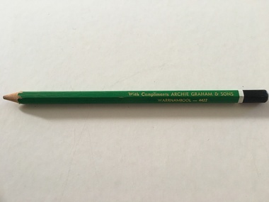 Warrnambool and District Historical Society Inc.
Artefact, Archie Graham & Son Warrnambool - 4423, Mid 20th century
... business in Warrnambool in the 1930s and was well-known for his many building projects in the city and his innovation in the industry. Archie Graham was a prominent member of the Uniting Church and a tireless worker in community affairs in Warrnambool for sixty years. He planned and organized the street decorations for the Warrnambool Centenary in 1947, was chairman of the committee that developed Albert Park...business in Warrnambool in the 1930s and was well-known for his many building projects in the city and his innovation in the industry. Archie Graham was a prominent member of the Uniting Church and a tireless worker in community affairs in Warrnambool for sixty years. He planned and organized the street decorations for the Warrnambool Centenary in 1947, was chairman of the committee that developed Albert Park ...This pencil was used as an advertising medium for the Warrnambool firm of Archie Graham and Sons. It was given to customers of the firm. Archie Graham (1906-1992) commenced a building business in Warrnambool in the 1930s and was well-known for his many building projects in the city and his innovation in the industry. Archie Graham was a prominent member of the Uniting Church and a tireless worker in community affairs in Warrnambool for sixty years. He planned and organized the street decorations for the Warrnambool Centenary in 1947, was chairman of the committee that developed Albert Park and the Reid Oval and was active in Rotary Club and Cricket Club affairs. He was also a member of the Warrnambool Technical School Council. Today the building in Timor Street for senior citizens and other community use is named after Archie Graham. This pencil is of interest as a memento of the type of complimentary article given to customers of businesses in Warrnambool in the mid 20th century. It is also a memento of Archie Graham, an important businessman and community worker in Warrnambool in the 20th century. This is a large six-sided wooden pencil sharpened at one end. The pencil is painted green with a white band near the top and a black-colored end rounded at the top. The paint on the pencil is slightly chipped. The inside of the pencil contains graphite for writing or drawing. The business name on the side of the pencil is inscribed in gold lettering. ‘With Compliments ARCHIE GRAHAM & SONS WARRNAMBOOL – 4422’ archie graham, warrnambool, history of warrnambool -
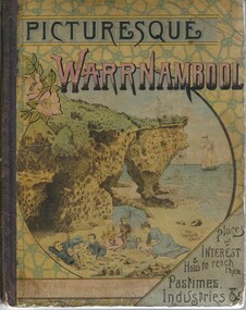 Warrnambool and District Historical Society Inc.
Book, Picturesque Warrnambool, 1891
... The Mechanics Institute, the Common, Albert Park, the rivers, the Museum and the Sea Baths are all mentioned. The various drawings and advertisements provide a list of businesses which were prevalent at the time. ...The Mechanics Institute, the Common, Albert Park, the rivers, the Museum and the Sea Baths are all mentioned. The various drawings and advertisements provide a list of businesses which were prevalent at the time. ...This book presents a pictorial and written record of Warrnambool in 1891.It covers a wide range of topics. It provides statistical evidence relating to public buildings and organisations of that era, as well as basic information about district points of interest. The Mechanics Institute, the Common, Albert Park, the rivers, the Museum and the Sea Baths are all mentioned. The various drawings and advertisements provide a list of businesses which were prevalent at the time. As this book is one of only two complete copies documented to be still in existence, it is of considerable significance and importance to our collection. The drawings and text are artistically very much of the era and are aesthetically pleasing. Cardboard cover with picture of people on beach in tones of yellow, pink and blue sitting within a circle. Dark purple cloth spine binding. Back cover has drawing of Western Hotel. Pages are not numbered and there are a number of coloured and black and white drawings. Title is in dark purple and Warrnambool is in pink and blue tonesOn front cover “The Mermaids Caves” 1896. 1891 written in pen beneath roman numerals on bottom of title page. List of numbers written down title page in black pen.warrnambool, picturesque warrnambool, warrnambool 1891,, warrnambool, warrnambool 1891 -
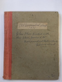 Warrnambool and District Historical Society Inc.
Book, Picturesque Warrnambool, C1891
... The Mechanics Institute, the Common, Albert Park, the rivers, the Museum and the Sea Baths are all mentioned. The various drawings and advertisements provide a list of businesses which were prevalent at the time....The Mechanics Institute, the Common, Albert Park, the rivers, the Museum and the Sea Baths are all mentioned. The various drawings and advertisements provide a list of businesses which were prevalent at the time. ...This book presents a pictorial and written record of Warrnambool in 1891.It covers a wide range of topics. It provides statistical evidence relating to public buildings and organisations of that era, as well as basic information about district points of interest. The Mechanics Institute, the Common, Albert Park, the rivers, the Museum and the Sea Baths are all mentioned. The various drawings and advertisements provide a list of businesses which were prevalent at the time.As this book is one of only two complete copies documented to be still in existence, it is of considerable significance and importance to our collection. The drawings and text are artistically very much of the era and are aesthetically pleasing.Plain grey card cover with fabric binding. Handwriting on front cover and inside front cover. It contains a number of black and white and coloured plates depicting scenes of Warrnambool and the district. Approximately 70 pages.Old Warrnambool about 1891 hand written on label on front cover, underneath is also written “When I have finished with these please forward to Warrnambool Historical Society Warrnambool. D 77, 252 in bottom RHC of cover. picturesque warrnambool,, warrnambool 1891, -
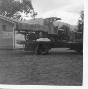 Kiewa Valley Historical Society
Photograph- Paddy Fisher's truck at Tawonga, 13th Dec. 1969
... business commenced in 1785. In 1926 the Fisher family of Mongan's Bridge took delivery of the 1923 Hallford truck which was used on the farm to transport cream to the Kiewa Butter Factory in Tangambalanga. In 1967, the truck was sold to Mr Greg Bedstead and other members of the Kiewa Valley Historical Society for the KVHS who reimbursed them at a later date. The truck was housed at the Butter Factory for many years and was paraded on special occasions. Photograph shows truck parked...business commenced in 1785. In 1926 the Fisher family of Mongan's Bridge took delivery of the 1923 Hallford truck which was used on the farm to transport cream to the Kiewa Butter Factory in Tangambalanga. In 1967, the truck was sold to Mr Greg Bedstead and other members of the Kiewa Valley Historical Society for the KVHS who reimbursed them at a later date. The truck was housed at the Butter Factory for many years and was paraded on special occasions. Photograph shows truck parked ...The Hallford truck was made by J & E Hall, of Dartford, England, whose business commenced in 1785. In 1926 the Fisher family of Mongan's Bridge took delivery of the 1923 Hallford truck which was used on the farm to transport cream to the Kiewa Butter Factory in Tangambalanga. In 1967, the truck was sold to Mr Greg Bedstead and other members of the Kiewa Valley Historical Society for the KVHS who reimbursed them at a later date. The truck was housed at the Butter Factory for many years and was paraded on special occasions. Photograph shows truck parked outside the original Kiewa Valley Historical Museum which was located at Tawonga Caravan Park and was later relocated to its current location at the Mt Beauty Information Centre. This truck was used to transport cream to the Kiewa Butter Factory from the Fisher family's dairy farm at Mongan's Bridge. At other times a tyre was removed and a belt attached to run a chaff cutter. This truck has historical significance as it is presentative of vehicles which were used by farmers to transport cream to the butter factories by a local family. Furthermore, it has social significance as KVHS members combined their finances to purchase this truck so it would be part of our collection. It is well provenanced and has an excellent interpretive capacity.Black and white photograph of Paddy Fisher's truck on a flat bed truck, outside the original Kiewa Valley Historical MuseumSmall typed tag on back of photo 'Paddy fisher's truck taken at Tawonga Caravan Park 13th December, 1969'hallford truck, fisher family, kiewa valley farmers, mongan's bridge, cream truck