Showing 101 items matching "calder highway"
-
 Charlton Golden Grains Museum Inc
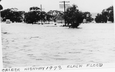
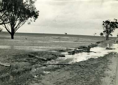
Photograph, B/W photograph 1973 Flash Flood on Calder Highway
... B/W photograph 1973 Flash Flood on Calder Highway......Calder Highway...1973 Flash Flood on Calder Highway...Unframed B/W photograph 1973 Flash Flood on Calder Highway...Flood Calder Highway, Flash flood...Charlton Golden Grains Museum Inc 1 High Street Charlton goldfields 1973 Flash Flood on Calder Highway Charlton Calder Highway Floods Flood Calder Highway, Flash flood Unframed B/W photograph 1973 Flash Flood on Calder Highway B/W photograph 1973 Flash Flood on Calder Highway Photograph Photograph ...1973 Flash Flood on Calder HighwayUnframed B/W photograph 1973 Flash Flood on Calder HighwayFlood Calder Highway, Flash floodcharlton, calder highway, floods -
 Charlton Golden Grains Museum Inc
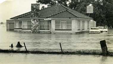
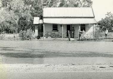
Photograph, Cameron, Ian, 1973 Flood W. Fitzpatrick's House on Calder Highway, Feb 1973
... Fitzpatrick's House on Calder Highway......Calder Highway...W Fitzpatrick's house on Calder Highway surrounded by flood water from flooded Yeungroon Creek....Calder Highway, Charlton, Victoria, Australia...Fitzpatrick's House on Calder Highway Photograph Photograph Cameron, Ian Charlton Tribune ...1973 flood. W. Fitzpatrick's house on Calder Hwy, surrounded by flood water from Yeungroon Creek.B/W photograph of 1973 flood. W Fitzpatrick's house on Calder Highway surrounded by flood water from flooded Yeungroon Creek.charlton, calder highway, yeungroon, floods -
 Charlton Golden Grains Museum Inc
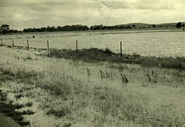
Photograph, Charlton Tribune, B/W photograph of 1971 flood, Nov 1971
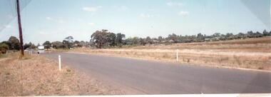
... ...Calder Highway...Paddocks and roadside along Calder Highway....Paddocks and roadside along Calder Highway....Calder Highway, Charlton, Victoria, Australia...Paddocks and roadside along Calder Highway. Charlton Calder Highway Floods Unframed photograph of 1971 flood. ...1971 flood at Charlton. Paddocks and roadside along Calder Highway.Unframed photograph of 1971 flood. Paddocks and roadside along Calder Highway.charlton, calder highway, floods -
 Bendigo Historical Society Inc.
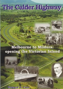
Book - THE CALDER HIGHWAY, 2006
... THE CALDER HIGHWAY......calder highway...The Calder Highway - Melbourne to Mildura: opening the Victorian Inland. 128 pages with photos and illustrations, maps. ...History House 11 Mackenzie Street Bendigo goldfields STATE INFRASTRUCTURE Water Supply calder highway Calder Highway infrastructure Howard A. ...The Calder Highway - Melbourne to Mildura: opening the Victorian Inland. 128 pages with photos and illustrations, maps. Inscribed on fly page ' to Jim Evans with my thanks, Howard Carr'Howard A. Carrstate infrastructure, water supply, calder highway, calder highway, infrastructure -
 Charlton Golden Grains Museum Inc
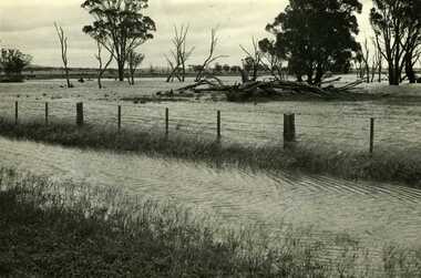
Photograph, Charlton Tribune, Flood Water damage to McGurk's fence, c. 1980
... Calder Highway...Flood 1971, damage to Mc Gurk's fencing on Calder Highway....B/W photo of flood water & damage to McGurk's fence on Calder Highway in 1971 flood....Calder Highway, Charlton, Wimmera Mallee, Victoria, Australia...Charlton Golden Grains Museum Inc 1 High Street Charlton goldfields Flood 1971, damage to Mc Gurk's fencing on Calder Highway. Calder Highway Charlton Floods B/W photo of flood water & damage to McGurk's fence on Calder Highway in 1971 flood. ...Flood 1971, damage to Mc Gurk's fencing on Calder Highway.B/W photo of flood water & damage to McGurk's fence on Calder Highway in 1971 flood.calder highway, charlton, floods -
 Charlton Golden Grains Museum Inc
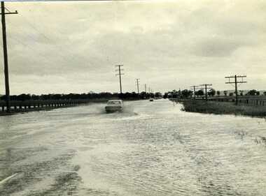
Photograph, Charlton Tribune, 1973 Flood, Nov 1971
... Calder Highway...1971 flood, Car driving through flood water on Calder Highway, Charlton, Victoria...Car driving through floodwater on Calder Highway....Calder Highway, Charlton, Victoria, Australia...Charlton Golden Grains Museum Inc 1 High Street Charlton goldfields 1971 flood, Car driving through flood water on Calder Highway, Charlton, Victoria Calder Highway Floods B/W photograph of 1971 flood. ...1971 flood, Car driving through flood water on Calder Highway, Charlton, VictoriaB/W photograph of 1971 flood. Car driving through floodwater on Calder Highway.calder highway, floods -
 Charlton Golden Grains Museum Inc
Photograph, Charlton Tribune, 1973 February Flood, Feb 1973
... ...Calder Highway...Old Ive's house with floodwater to front fence on the Calder Highway opposite Charlton Park Gates. Mrs Gloria Jordan....Old Ive's house with floodwater to front fence on Calder Highway opposite Charlton Park gates. Photo used in Charlton Tribune on 09/07/1973 P4....Ive's House, Calder Highway, Charlton, Victoria, Australia...Charlton Calder Highway Local Brick Floods B/W Photograph of February 1973 flood. ...Feb 1973 flood Charlton, Victoria. Old Ive's house with floodwater to front fence on the Calder Highway opposite Charlton Park Gates. Mrs Gloria Jordan.B/W Photograph of February 1973 flood. Old Ive's house with floodwater to front fence on Calder Highway opposite Charlton Park gates. Photo used in Charlton Tribune on 09/07/1973 P4.charlton, calder highway, local brick, floods -
 Charlton Golden Grains Museum Inc
Photograph, Charlton Tribune, B/W photograph of 1971 flood, Nov 1971
... ...Calder Highway...Paddocks & roadside along Calder Highway...Calder Highway, Charlton, Victoria, Australia...Charlton Golden Grains Museum Inc 1 High Street Charlton goldfields Charlton Calder Highway Floods B/W photograph of 1971 flood. ...B/W photograph of 1971 flood. Paddocks & roadside along Calder Highwaycharlton, calder highway, floods -
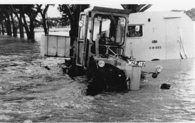
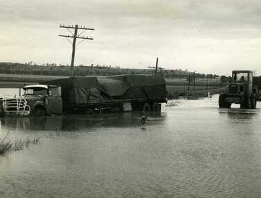 Charlton Golden Grains Museum Inc
Photograph, Cameron, Ian, Road Transport run off road in flood water 1971, 12/11/1971
... Calder Highway...Road transport run off Calder Highway in 1971 flood water. Shire grader trying to remove truck. ...Calder Highway, Charlton, Victoria, Australia...Charlton Golden Grains Museum Inc 1 High Street Charlton goldfields Road transport run off Calder Highway in 1971 flood water. Shire grader trying to remove truck. ...Road transport run off Calder Highway in 1971 flood water. Shire grader trying to remove truck. Used in Charlton Tribune Nov 12th, 1971.B/W photo of road transport run off Highway in flood water. Shire grader trying to remove truck.calder highway, charlton, floods -
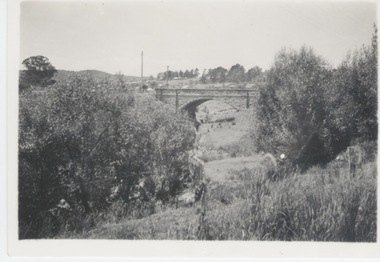
 Charlton Golden Grains Museum Inc
Photograph, 1981 Moderate flood Calder Highway Bridge over Avoca River Charlton Vic 3525
... 1981 Moderate flood Calder Highway Bridge over Avoca River Charlton Vic 3525...Calder Highway Bridge accross Avoca River Charlton Vic. 3525...Calder Highway Bridge accross Avoca River Charlton Vic. 3525 1981 Flood Landscape Coloured photograph 1981 Moderate flood Calder Highway Bridge over Avoca River Charlton Vic 3525 Photograph ...Landscape Coloured photographcalder highway bridge accross avoca river charlton vic. 3525, 1981 flood -
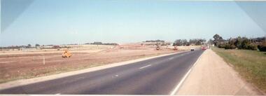 Hume City Civic Collection
Photograph
... calder highway...This photograph is of the duplication of the Calder Highway at Diggers Rest in the vicinity of Plumpton Road....A coloured panoramic view of the construction of the duplication of the Calder Highway in the vicinity of Plumpton Road. ...Hume City Civic Collection 44 Macedon Street Sunbury melbourne This photograph is of the duplication of the Calder Highway at Diggers Rest in the vicinity of Plumpton Road. calder highway diggers rest highway duplication road construction and maintenance plumpton road george evans collection A coloured panoramic view of the construction of the duplication of the Calder Highway in the vicinity of Plumpton Road. ...This photograph is of the duplication of the Calder Highway at Diggers Rest in the vicinity of Plumpton Road.A coloured panoramic view of the construction of the duplication of the Calder Highway in the vicinity of Plumpton Road. It is unmounted.calder highway, diggers rest, highway duplication, road construction and maintenance, plumpton road, george evans collection -
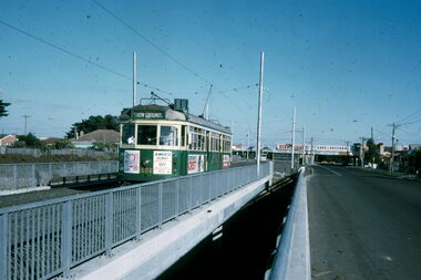 Melbourne Tram Museum
Slide - Calder Highway tram underpass Matthews Ave, Warren Doubleday, 22/5/1970
... Calder Highway tram underpass Matthews Ave....Photograph shows W7 class tram No. 1006 on the then new overbridge over Calder Highway in Matthews Ave. The tram is on tour and is showing "showgrounds" for fun. ...Yields information about Matthews Ave overbridge for the Calder Highway and W7 1006. tramways Matthews Ave W7 class tram 1006 Has in pencil slide number "8/71/38" Colour slide - Kodak cardboard mount Slide Calder Highway tram underpass Matthews Ave. ...Photograph shows W7 class tram No. 1006 on the then new overbridge over Calder Highway in Matthews Ave. The tram is on tour and is showing "showgrounds" for fun. Photo taken 16/5/1971.Yields information about Matthews Ave overbridge for the Calder Highway and W7 1006.Colour slide - Kodak cardboard mountHas in pencil slide number "8/71/38"tramways, matthews ave, w7 class, tram 1006 -
 Sunbury Family History and Heritage Society Inc.
Photograph, Rosa McCall, February 2014
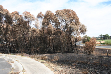
... ...Calder Highway...The cluster of trees beside the Calder Highway, north of Sunbury, was burnt in February 2014 when a grassfire started along the road and a severe wind change from the south took the flames across the dry countryside beyond Riddells Creek and beyond Clarkefield. ...Calder Highway, Sunbury, Victoria, Sunbury...The cluster of trees beside the Calder Highway, north of Sunbury, was burnt in February 2014 when a grassfire started along the road and a severe wind change from the south took the flames across the dry countryside beyond Riddells Creek and beyond Clarkefield. ...The cluster of trees beside the Calder Highway, north of Sunbury, was burnt in February 2014 when a grassfire started along the road and a severe wind change from the south took the flames across the dry countryside beyond Riddells Creek and beyond Clarkefield. The Bendigo rail line was damaged resulting in it being closed for repairs. This was one of the many fires experienced over that hot summer when the countryside was parched.A coloured digital photograph of a cluster of burnt trees by a roadsidegrassfires, calder highway, riddells creek -
 Sunbury Family History and Heritage Society Inc.
Photograph, Veronica Burgess, Diggers Rest Hotel, October 2008
... ...Calder Highway...Calder Highway, Diggers Rest, Victoria, Australia...The Diggers Rest has been one of the few early surviving hotels that were built along the former Mount Alexander Road, now Calder Highway, during the 1850s gold rush years. ...The damaged building in the photograph is the former Diggers Rest Hotel which was built on that site in 1854 It was a popular place during the 1970s Sunbury Pop Festivals as it was the closest hotel to the Pop Festival site. It was partly destroyed by a suspicious fire on 30th October 2008, which left the walls and chimney intact but the roof caved in. Since then there have been moves by the local community to either rebuild and reopen the venue or to demolish it.The Diggers Rest has been one of the few early surviving hotels that were built along the former Mount Alexander Road, now Calder Highway, during the 1850s gold rush years.This a non-digital coloured photograph of a double storey hotel building, which has been damaged by fire. The exterior walls are intact but the roof has collapsed.The building is beside a main road. diggers rest, diggers rest hotel, hotels, calder highway, gold rushes -
 Bendigo Historical Society Inc.
Photograph - JOSEPH BRADY COLLECTION: FLUMING BETWEEN MALMSBURY RESERVOIR AND CALDER HIGHWAY, 1934
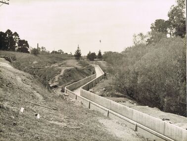
... JOSEPH BRADY COLLECTION: FLUMING BETWEEN MALMSBURY RESERVOIR AND CALDER HIGHWAY...Photograph JOSEPH BRADY COLLECTION: FLUMING BETWEEN MALMSBURY RESERVOIR AND CALDER HIGHWAY ...Black and white photograph: image shows concrete channel snaking down hill, top LH side appears to be bluestone mill with tall chimney. Trees on RH side of channel. Comments on the back of the photo 'Between Malmsbury Res and Calder Hwy. 8 feet wide 4 foot 6 inches deep. Taken 1934. JA 10/81 concrete grand fluming at 12.5 miles Main channel 8 feet wide 4 foot 6 inches high. Constructed 1928.'place, water, coliban race, john brady collection. coliban race -
 Port Melbourne Historical & Preservation Society
Photograph - Group with Port Melbourne Community Bus on Calder Highway, Pat Grainger, Aug 1993
... Group with Port Melbourne Community Bus on Calder Highway...highway by Pat Grainger. PMHPS members: Liana Thompson (3 from left; Wendy Morris (4 from left); Julie Allen (far right) transport - bus kath morris val salter (?) liana thompson mayors wendy morris - city librarian beatrice (betty) goddard julie allen Photograph black and white panoramic of group with Port Melbourne Community Bus on Calder Hwy August 1993 Photograph Group with Port Melbourne Community Bus on Calder Highway Pat Grainger ...This group took the free community bus to Bendigo to see daffodils at Kyneton and woollen mills at Bendigo. Photographed at apple market along the highway by Pat Grainger. PMHPS members: Liana Thompson (3 from left; Wendy Morris (4 from left); Julie Allen (far right)Photograph black and white panoramic of group with Port Melbourne Community Bus on Calder Hwy August 1993transport - bus, kath morris, val salter (?), liana thompson, mayors, wendy morris - city librarian, beatrice (betty) goddard, julie allen -
 Hume City Civic Collection
Photograph, 1990s
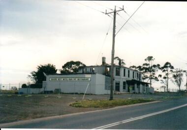
... It was the last standing and operating hotel along the Calder Highway between the towns of Keilor and Gisborne. ...Old Calder Highway, Diggers Rest, Victoria, Australia...It was the last standing and operating hotel along the Calder Highway between the towns of Keilor and Gisborne. ...The fire damaged building is the former Diggers Rest Hotel which was ruined by fire in the 1990s. It was the last standing and operating hotel along the Calder Highway between the towns of Keilor and Gisborne. A coloured photograph of a fire gutted building along a roadside with gum trees in the background. -
 Hume City Civic Collection
Photograph, 1990s
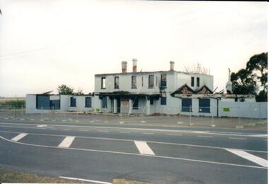
... The building which has been damaged by fire is the former Diggers Rest Hotel which was the only surviving hotel along the Calder Highway between the towns of Keilor and Gisborne a distance of approx. 32kms ...Old Calder Highway, Diggers Rest, Victoria, Australia...Hume City Civic Collection 44 Macedon Street Sunbury melbourne The building which has been damaged by fire is the former Diggers Rest Hotel which was the only surviving hotel along the Calder Highway between the towns of Keilor and Gisborne a distance of approx. 32kms Diggers Rest Hotels A coloured photograph of a grey rendered building, along a roadside, which has been damaged by fire with a temporary fence surrounding the building. ...The building which has been damaged by fire is the former Diggers Rest Hotel which was the only surviving hotel along the Calder Highway between the towns of Keilor and Gisborne a distance of approx. 32kms A coloured photograph of a grey rendered building, along a roadside, which has been damaged by fire with a temporary fence surrounding the building. diggers rest, hotels -
Malmsbury Historical Society
Photograph (Item), Bridge Over Calder Highway, Malmsbury ca2003
... Bridge Over Calder Highway, Malmsbury ca2003...Malmsbury Historical Society Malmsbury Mechanics Institute 71 Mollison Street Malmsbury daylesford-and-the-macedon-ranges People - "Tynan, Alexandra (Photographer)" Bridge Over Calder Highway, Malmsbury ca2003 Photograph Photograph ...People - "Tynan, Alexandra (Photographer)" -
 Hume City Civic Collection
Photograph
... old calder highway...The old Calder Highway before the construction of the duplication of the Calder Highway between the Railway crossing and Plumpton Road....Hume City Civic Collection 44 Macedon Street Sunbury melbourne The old Calder Highway before the construction of the duplication of the Calder Highway between the Railway crossing and Plumpton Road. old calder highway diggers rest plumpton road railways george evans collection A coloured panoramic view of the old Caler Highway at Diggers Rest. ...The old Calder Highway before the construction of the duplication of the Calder Highway between the Railway crossing and Plumpton Road.A coloured panoramic view of the old Caler Highway at Diggers Rest. It is unmounted.old calder highway, diggers rest, plumpton road, railways, george evans collection -
 Charlton Golden Grains Museum Inc
Photograph, Dunstan Gates, Charlton Showgrounds, c.1960
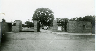
... Entrance gates to the Showgrounds (Charlton Park) on the Calder Highway. Named after Albert Dunstan, Victorian Premier. ...Calder Highway, Charlton, Wimmera Mallee, Victoria, Australia...Entrance gates to the Showgrounds (Charlton Park) on the Calder Highway. Named after Albert Dunstan, Victorian Premier. ...Dunstan Gates, Charlton Showgrounds. c.1960. Entrance gates to the Showgrounds (Charlton Park) on the Calder Highway. Named after Albert Dunstan, Victorian Premier. A public meeting was reported in the Charlton Tribune 1950, 19/05 deciding to erect a memorial to the late Sir Albert Dunstan. Setting an objective of 5000 pounds. The shire council had given 500 pounds as a lead. It was decided that a memorial gateway with a suitable plaque would be erected in front of Charlton Park in recognition of his service to Charlton, the electorate and the State.B/w photo of the Dunstan Gates c.1960. There are markings left by tape adhesive on the left and right of the photo.charlton, parks, dunstan, charlton park, memorial -
 Hume City Civic Collection
Photograph
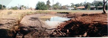
... old calder highway...A photo of Old Calder Highway in Diggers Rest with houses on one side and a manmade waterhole on the other side beside the railway line. ...Hume City Civic Collection 44 Macedon Street Sunbury melbourne A photo of Old Calder Highway in Diggers Rest with houses on one side and a manmade waterhole on the other side beside the railway line. ...A photo of Old Calder Highway in Diggers Rest with houses on one side and a manmade waterhole on the other side beside the railway line. The railway crossing can be seen in the background next to the railway station.A colour photograph of a waterhole on the side of the road and beside a railway line. It is unmounted.old calder highway, diggers rest, diggers rest railway station, railways, george evans collection -
 Charlton Golden Grains Museum Inc
Photograph, Cameron, Ian, 01/02/1973
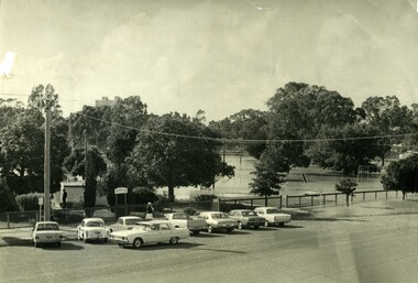
... Gordon Park, Calder Highway, Charlton, Mallee, Victoria, Australia ...Taken by the editor of The Charlton Tribune Ian Cameron. Of the 1973 flood at Gordon Park and Croquet Club. Highest flood since 1956, 25 feet 1 1/2 at the bridge, 4 inches of rain fell in the catchment. Road damage after the flood was estimated to be $74,800.Large sepia photograph unframed, creased in top RH corner, surface torn on left edge. Unmountedgordon park, croquet club, charlton, floods -
 Sunbury Family History and Heritage Society Inc.
Photograph
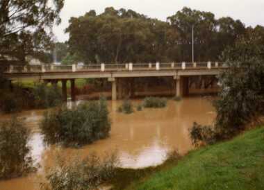
... ...Calder Highway...The single span bluestone bridge is on the Calder Highway at the base of Corkscrew Hill between Gap Road and the town of Gisborne. ...Sunbury Global Learning Centre Macedon Street Sunbury melbourne The single span bluestone bridge is on the Calder Highway at the base of Corkscrew Hill between Gap Road and the town of Gisborne. ...The single span bluestone bridge is on the Calder Highway at the base of Corkscrew Hill between Gap Road and the town of Gisborne. In the early 1990s the highway was widened and dual carriageways constructed, as a result the traffic no longer travelled along the winding Corkscrew Hill road. The bridge still stands between the two carriageways. A non-digital black and white photograph with a cream border of a single arched stone bridge spanning a watercourse. Small bushes are growing in the foreground and there are some buildings dotted across the hill in the middle distance.bridges, corkscrew hill, calder highway -
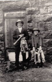 Sunbury Family History and Heritage Society Inc.
Photograph
... ...Calder Highway...The Bald Hill Hotel at Aitkens Gap on the Bendigo Road (Calder Highway) was built by George Millett in 1854 and functioned until the gold began to run out after the 1850s Victorian Goldrush....The Bald Hill Hotel at Aitkens Gap on the Bendigo Road (Calder Highway) was built by George Millett in 1854 and functioned until the gold began to run out after the 1850s Victorian Goldrush. ...Frank Millet and his cousin, Hopper Cahill are standing in front of the Aitkins Gap Gaol after spending the day shooting rabbits in 1922. In the 1860s the gaol and stables were sold to George Millett and added to the Millett property. The barracks and a new farm homestead were built by Mick Morrison. The Bald Hill Hotel at Aitkens Gap on the Bendigo Road (Calder Highway) was built by George Millett in 1854 and functioned until the gold began to run out after the 1850s Victorian Goldrush. The Millett family continued farming in the area until 1967. They also owned and operated other hotels in the local area. A non-digital scanned black and white photograph of a man and a boy standing in front of a bluestone building while holding some dead rabbits. frank millett, hopper cahill, aitkins gap gaol, calder highway, george millett, bald hill hotel -
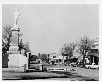 Charlton Golden Grains Museum Inc
Photograph - Black and white photo looking up High St Charlton 1960s, Murray View Snapshots, 1960s
... Calder Highway Charlton...High St Charlton 1960s Charlton 1960s High St Charlton War Memorial Charlton Calder Highway Charlton Black and white photo Looking up High St from the War Memorial 1960s Photograph Black and white photo looking up High St Charlton 1960s Murray View Snapshots ...High St Charlton 1960sBlack and white photo Looking up High St from the War Memorial 1960sCalder Highway Charltoncharlton 1960s, high st charlton, war memorial charlton -
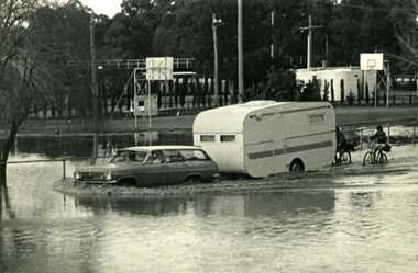 Charlton Golden Grains Museum Inc
Photograph - B/W Photograph of 1973 flood near Gordon Park, 1973 Flood, c. Feb 1973
... Calder Highway, Charlton, Victoria, Australia ...1973 flood near Gordon Park, Car and caravan driving through flood water and road followed by two bicycles. Campers forced out of Gordon Park by rising flood waters c.1973Unframed B/W photograph gordon park, charlton, floods -
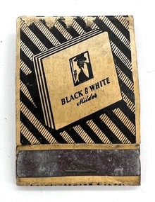 Kew Historical Society Inc
Functional object - Matchbox, 1950s
... Black & White / Milder / The Log Cabin Restaurant / Macedon / Calder Highway / Phone 257...Kew Historical Society Inc Kew Court House 188 High Street Kew melbourne containers matches the log cabin restaurant -- macedon Black & White / Milder / The Log Cabin Restaurant / Macedon / Calder Highway / Phone 257 Customised matchbox used as promotional materials for the Log Cabin, Macedon. ...Customised matchbox used as promotional materials for the Log Cabin, Macedon. The obverse depicts a man smoking a cigarette against an abstract black and white background. The reverse contains information about the restaurant. Black & White / Milder / The Log Cabin Restaurant / Macedon / Calder Highway / Phone 257containers, matches, the log cabin restaurant -- macedon -
 Charlton Golden Grains Museum Inc
Photograph, Cameron, Ian, c.1973
... Calder Highway...Charlton Golden Grains Museum Inc 1 High Street Charlton goldfields CRB grader towing a caravan 1973 Flood - washed off road before Yeungroon turnoff in 1973 flood. Calder Highway Yeungroon Floods B/W photograph CRB grader towing a caravan 1973 Flood - washed off road before Yeungroon turnoff in 1973 flood Photograph Photograph Cameron, Ian ...CRB grader towing a caravan 1973 Flood - washed off road before Yeungroon turnoff in 1973 flood.B/W photograph CRB grader towing a caravan 1973 Flood - washed off road before Yeungroon turnoff in 1973 floodcalder highway, yeungroon, floods -
Federation University Historical Collection
Document - Reports, Large Cats, Thylacenes and Large Predators Sigtings, 1975-1985 and 2002-2011
... ...calder highway sightings...The folder was collected for research being conducted by David Waldron. australian mythical animals collection david waldron brian waters moonambel joyce collins ian smith thylacene marrarkuli burragorang m.g. hornocker mt bepcha billywing upland john a. henry bryan wlaters ken bodinnar harcourt kevin farley fowlers bay carolyn hodges puma macarthur paynesville john aldreson animal damage control mountain lion bryan walters cougar big cat maryborough joan kirner bernard mace tasmanian tigers d.g. willey calder highway sightings kevin phelen mt richmond national park feral cat felis catus lancefield pyalong broadford pyalong pantherleopard porsche park dick shaw big cats in victoria peter hall lyn sellens south gippsland plaster cast foot cast unidentified wildlife john seeback michael moss carnivores halls gap halls gap puma scats kooreh ballan ballan large cat a.g. kerr south gippsland tasmanian tiger sightings central victorian puma otways wilsons promontory john higgins tasmanian wolf j.k. depmster vermin lion cooper's creek warrego river dingo thylacinus cynocephalus mirboo north newham operation puma victoria australian skeptics kangaroo ground rare fauna black wildcat pyalong panther bob warneke black puma maryborough puma creswick panther cape bridgewater pyrenees panther footprints daisy hill bung bong phantom puma geranium springs maurice hornocker Folder of correspondence and newsclips relating to "Big Cats" and other large predators. ...The folder of correspondence is the result of a Freedom of Information request made to the Department of Sustainability and Environment in 2011. The folder was collected for research being conducted by David Waldron.Folder of correspondence and newsclips relating to "Big Cats" and other large predators. Please note: sections of this file are closed to protect the privacy of correspondents.australian mythical animals collection, david waldron, brian waters, moonambel, joyce collins, ian smith, thylacene, marrarkuli, burragorang, m.g. hornocker, mt bepcha, billywing upland, john a. henry, bryan wlaters, ken bodinnar, harcourt, kevin farley, fowlers bay, carolyn hodges, puma, macarthur, paynesville, john aldreson, animal damage control, mountain lion, bryan walters, cougar, big cat, maryborough, joan kirner, bernard mace, tasmanian tigers, d.g. willey, calder highway sightings, kevin phelen, mt richmond national park, feral cat, felis catus, lancefield, pyalong, broadford, pyalong pantherleopard, porsche park, dick shaw, big cats in victoria, peter hall, lyn sellens, south gippsland, plaster cast, foot cast, unidentified wildlife, john seeback, michael moss, carnivores, halls gap, halls gap puma scats, kooreh, ballan, ballan large cat, a.g. kerr, south gippsland tasmanian tiger sightings, central victorian puma, otways, wilsons promontory, john higgins, tasmanian wolf, j.k. depmster, vermin, lion, cooper's creek, warrego river, dingo, thylacinus cynocephalus, mirboo north, newham, operation puma victoria, australian skeptics, kangaroo ground, rare fauna, black wildcat, pyalong panther, bob warneke, black puma, maryborough puma, creswick panther, cape bridgewater, pyrenees panther, footprints, daisy hill, bung bong, phantom puma, geranium springs, maurice hornocker