Showing 93 items matching "camp remains"
-
 Tatura Irrigation & Wartime Camps Museum
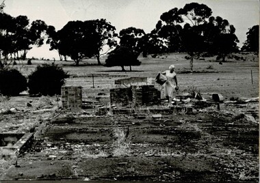
Photograph, Dean Clark, Camp 3 Remains, 1989
... Camp 3 Remains...internment camp remains...Photograph of Lil Kuhnle walking through the remains of Camp 3. Copy of photograph original held by R & L. ...Black and white photograph of a lady remains of Internment Camp 3 site....Camp 3 Remains Photograph Photograph Dean Clark ...Photograph of Lil Kuhnle walking through the remains of Camp 3. Copy of photograph original held by R & L. Kuhnle. Duplicate copy on foam.Black and white photograph of a lady remains of Internment Camp 3 site.on back: Lil Kuhnle - internment camp siteinternment camp remains, kuhnle l, dean clark -
 Tatura Irrigation & Wartime Camps Museum
Photograph, Arthur Knee, Camp 13 latrine block remains, 1989
... Camp 13 latrine block remains...camp 13...pow...german pow...internment camps...ruins...murchison victoria...latrine remains...Camp 13, German compound. Latrine block, concrete remains, eucalyptus in background....Camp 13, Camp Road, Murchison, Victoria. Concrete remains, latrine block....Tatura Irrigation & Wartime Camps Museum 49 Hogan Street Tatura the-murray Camp 13, German compound. Latrine block, concrete remains, eucalyptus in background. camp 13 pow german pow internment camps ruins murchison victoria latrine remains camp 13 Camp 13, Camp Road, Murchison, Victoria. ...Camp 13, German compound. Latrine block, concrete remains, eucalyptus in background.Camp 13, Camp Road, Murchison, Victoria. Concrete remains, latrine block.camp 13, pow, german pow, internment camps, ruins, murchison victoria, latrine remains camp 13 -
 Tatura Irrigation & Wartime Camps Museum
Audio Tape, Walking tour of Camp 1 with Jenny Dumble who conducted an archaelogical survey thereof, 1990
... ...Camp remains...Walking tour of camp 1 with Jenny Dumble who had just completed an archaeological survey of the camp remains. Members of T & D Historical Society accompanied....Tatura Irrigation & Wartime Camps Museum 49 Hogan Street Tatura the-murray Walking tour of camp 1 with Jenny Dumble who had just completed an archaeological survey of the camp remains. Members of T & D Historical Society accompanied. ...Walking tour of camp 1 with Jenny Dumble who had just completed an archaeological survey of the camp remains. Members of T & D Historical Society accompanied.audio tape 90 minutesCamp 1 Jenny Dumblejenny dumble, archaeological survey, camp remains -
 Tatura Irrigation & Wartime Camps Museum
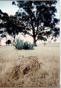
Photograph, Camp 3 remains
... Camp 3 remains...Remains of barbed wire at Camp 3....Camp 3 remains Photograph Photograph ...Remains of barbed wire at Camp 3.Colour photograph on foam showing some barbed wire and cactus near some trees at Camp 3.internment camp 3 -
Tatura Irrigation & Wartime Camps Museum
CD, Camp 2 2006 visit, 2006
... Camp 2 remains...19 photographs of the remains of camp 2 Tatura....Camp 2 remains Camp 2 visit 2006 Gold coloured disc, green and blue text. ...19 photographs of the remains of camp 2 Tatura.Gold coloured disc, green and blue text.camp 2 remains, camp 2 visit 2006 -
 Tatura Irrigation & Wartime Camps Museum
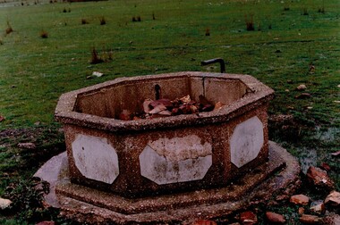
Photograph, Ornamental Pond, 1989
... ...Camp remains...Coloured photograph of ornamental pond remains at entrance to German internees compound at Camp 13 ...German Internees Italian Internees POW's Camp remains Camp 13 Ornamental ponds Coloured photograph of ornamental pond remains at entrance to German internees compound at Camp 13 Ornamental Pond Photograph Photograph ...Camp 13 was occupied by German and Italian Internees.Coloured photograph of ornamental pond remains at entrance to German internees compound at Camp 13 german internees, italian internees, pow's, camp remains, camp 13, ornamental ponds -
Tatura Irrigation & Wartime Camps Museum
Photograph, 1989
... ...Camp remains...Camp 1 Tatura Victoria German Internees Italian Internees POW's Camp remains Coloured photograph of stone steps leading up to the hall. ...The steps and cafe were structure that were part of Camp 1 which was occupied by German and Italian internees.Coloured photograph of stone steps leading up to the hall. Foundation walls of the cafe at the rear. 3 low long steps in foreground, low wall at base of gum trees at rear of photograph.camp 1, tatura victoria, german internees, italian internees, pow's, camp remains -
 Tatura Irrigation & Wartime Camps Museum
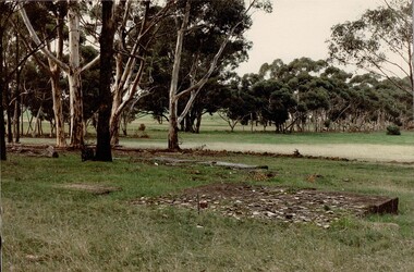
Photograph, Camp 1 Sports Ground, 1989
... ...internment camp remains...The open grassed area is the remains of the football ground constructed at Camp 1. Foam backed copy in file....Foam backed copy in file. camp 1 tatura victoria internment camps internment camp football fields internment camp remains Coloured photograph. In foreground there is a large, flat, low, rectangle of concrete rubble. ...The open grassed area is the remains of the football ground constructed at Camp 1. Foam backed copy in file.Coloured photograph. In foreground there is a large, flat, low, rectangle of concrete rubble. To the left of this concrete is a smaller rectangle of concrete. In centre of photograph is an open grassed area flanked by trees.camp 1, tatura victoria, internment camps, internment camp football fields, internment camp remains -
 Tatura Irrigation & Wartime Camps Museum
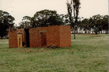
Photograph, Camp 1 prison, 1989
... ...camp building remains...The building is the remains of the prison at Camp 1. Foam backed copy in file....Foam backed copy in file. camp 1 tatura victoria camp goals camp building remains Coloured photograph. Red brick building in foreground. ...The building is the remains of the prison at Camp 1. Foam backed copy in file.Coloured photograph. Red brick building in foreground. To left of building there is a wooden door. Two other doorways, no doors, flat roof.camp 1, tatura victoria, camp goals, camp building remains -
Tatura Irrigation & Wartime Camps Museum
Photograph, 1989
... Internment camp building remains...The concrete strips are the remains of the bowling alley built at Camp 1....Camp 1 Tatura Victoria Internment camps Internment camp entertainment Bowling alley Internment camp building remains Coloured photograph. Two concrete strips extending from front to back of photograph. ...The concrete strips are the remains of the bowling alley built at Camp 1.Coloured photograph. Two concrete strips extending from front to back of photograph. At rear of strips are two free standing concrete walls. Trees have fallen over concrete strips in foreground.camp 1, tatura victoria, internment camps, internment camp entertainment, bowling alley, internment camp building remains -
Tatura Irrigation & Wartime Camps Museum
Multi ringed folder, Kaye Watson, Internment camp No 3. Rushworth Migrant camp
... The camp sites today are on private property, and as they were dismantled after the war, and on the closure of the Migrant camp, very little physical evidence remains today....Many pages, with 12 photos on each page, of scenes showing the remains from camp 3...Camp 3 Rushworth Many pages, with 12 photos on each page, of scenes showing the remains from camp 3 Internment camp No 3. ...The camp sites today are on private property, and as they were dismantled after the war, and on the closure of the Migrant camp, very little physical evidence remains today.Camp 3 held 1000 internees, Germans, Jews and Italians, including German Lutheran families from New Guinea, German families from Palestine (Templer settlement) and Austrian Jewish refugees. After the war camp 3 became the first camp for Displaced persons in Victoria, where families could live until work and accommodation was found for them.Many pages, with 12 photos on each page, of scenes showing the remains from camp 3camp 3 rushworth -
Tatura Irrigation & Wartime Camps Museum
Photograph, Arthur Knee, 1989
... Camp 13, German compound, concrete remains of kitchen complex...Camp 13, Camp Road, Murchison, Victoria. Remains of concrete kitchen complex, large cactus mid distance, native bush background...Tatura Irrigation & Wartime Camps Museum 49 Hogan Street Tatura the-murray Camp 13, German compound, concrete remains of kitchen complex camp 13 pow german pow internment camps murchison victoria ruins Camp 13, Camp Road, Murchison, Victoria. ...Camp 13, German compound, concrete remains of kitchen complexCamp 13, Camp Road, Murchison, Victoria. Remains of concrete kitchen complex, large cactus mid distance, native bush backgroundcamp 13, pow, german pow, internment camps, murchison victoria, ruins -
Tatura Irrigation & Wartime Camps Museum
CD, Mutsumi Tsuda, Camp 1 Tour 2009. Australian - Japan National Archives, 2009
... Tour of remains of Camp 1 site in November 2009 and pictures of Australia - Japan Nat. archives....Tatura Irrigation & Wartime Camps Museum 49 Hogan Street Tatura the-murray Tour of remains of Camp 1 site in November 2009 and pictures of Australia - Japan Nat. archives. camp 1 visit 2009 Japanese internees Silver CD with silver and black text Camp 1 Tour 2009. ...Tour of remains of Camp 1 site in November 2009 and pictures of Australia - Japan Nat. archives.Silver CD with silver and black textcamp 1 visit 2009, japanese internees -
 Tatura Irrigation & Wartime Camps Museum
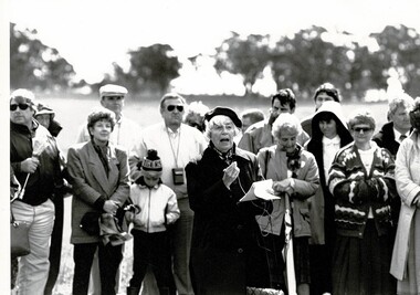
Photograph, Lilo Thaler at Camp 3 site, 21 September 1991
... A visit from the German Templer Society who visited the remains of Camp 3 in September 1991...Tatura Irrigation & Wartime Camps Museum 49 Hogan Street Tatura the-murray A visit from the German Templer Society who visited the remains of Camp 3 in September 1991 templer society mrs lilo thaler german templer society Black and white photograph of Mrs Lilo Thaler addressing the Templer families at the site of the old Camp 3. 21 September 1991. ...A visit from the German Templer Society who visited the remains of Camp 3 in September 1991Black and white photograph of Mrs Lilo Thaler addressing the Templer families at the site of the old Camp 3. 21 September 1991.templer society, mrs lilo thaler, german templer society -
 Tatura Irrigation & Wartime Camps Museum
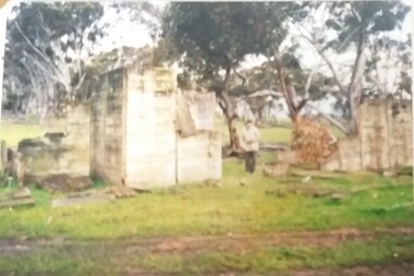
Photograph, Eberhard Schuster, September 1991
... Camp 1 German wool buyer, Eberhard Schuster, looking at some of the remains at Camp 1....Tatura Irrigation & Wartime Camps Museum 49 Hogan Street Tatura the-murray Camp 1 German wool buyer, Eberhard Schuster, looking at some of the remains at Camp 1. german wool buyers eberhard schuster camp 1 Colour photograph of Mr Eberhard Schuster, German wool buyers, a short distance of him standing near the building remnants of camp, some 300 cm (10 ft) high. ...Camp 1 German wool buyer, Eberhard Schuster, looking at some of the remains at Camp 1.Colour photograph of Mr Eberhard Schuster, German wool buyers, a short distance of him standing near the building remnants of camp, some 300 cm (10 ft) high.german wool buyers, eberhard schuster, camp 1 -
 Greensborough Historical Society
Photograph - Digital image, Marilyn Smith et al, Janefield Precinct: Looking toward grave area from camp, 27/11/2014
... Janefield Precinct: Looking toward grave area from camp. The remains of this site are between Greensborough and Janefield. ...Greensborough Historical Society 34A Glenauburn Road Lower Plenty Lower Plenty melbourne Janefield Precinct: Looking toward grave area from camp. The remains of this site are between Greensborough and Janefield. ...Janefield Precinct: Looking toward grave area from camp. The remains of this site are between Greensborough and Janefield. A RAAF Hygiene Training Camp was located on the Plenty River, just south of the Janefield community. It was in use from 1944 to 1946. The Camp was constructed from salvaged materials. Instruction included building and maintenance of grease traps, latrines, elementary plumbing and carpentry.Early remains of a WW2 training camp Digital colour photograph. -
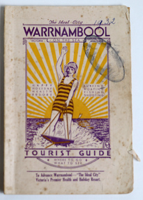 Warrnambool and District Historical Society Inc.
Booklet - Warrnambool Tourist Booklet, Warrnambool Progress Association, Warrnambool On the Sea, Victoria, Australia, Tourist Guide, 1932
... The Warrnambool Progress Association, formed in 1927, recognized the changing nature of tourism in Australia with the increasing ownership of motor vehicles and so the Warrnambool beaches and camping holidays were highlighted. Today tourism in Warrnambool remains a key component of the city's economy because of its beaches, coastal views, sporting events, winter whales and its proximity to other tourist attractions. ...The Warrnambool Progress Association, formed in 1927, recognized the changing nature of tourism in Australia with the increasing ownership of motor vehicles and so the Warrnambool beaches and camping holidays were highlighted. Today tourism in Warrnambool remains a key component of the city's economy because of its beaches, coastal views, sporting events, winter whales and its proximity to other tourist attractions. ...Warrnambool Tourist GuideThis is a booklet with a cream cover featuring a sketch of a woman waterskiing and blue printing. The pages contain black and white photographs, advertisements, two maps and printed text. There is one fold-out page. The booklet is stapled and bound with glue.non-fictionWarrnambool Tourist Guidewarrnambool tourism, warrnambool progress association -
 Bendigo Military Museum
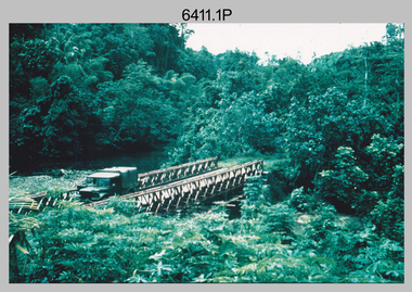
Photograph - Royal Australian Survey Corps Surveyors in the Field – Project Cutlass, New Guinea, 1956 – 1957
... Survey base camp, New Ireland. .6) - Photo, black & white, 1956-1957. Geoff Helsham with possible human remains, New Ireland. .7) - Photo, black & white, 1956-1957. ...Survey base camp, New Ireland. .6) - Photo, black & white, 1956-1957. Geoff Helsham with possible human remains, New Ireland. .7) - Photo, black & white, 1956-1957. ...This is a set of 23 photographs of surveyors and support staff in the field undertaking tasks in New Guinea 1956 – 1957. The surveyors were employed in the establishment of mapping and geodetic control for Project Cutlass, the “Ship-Shore” survey of the New Ireland province. In this survey operation surveyors used theodolites to observe horizontal and vertical angles and chains to measure base line distances between survey stations. Bob Skitch shown in photo .7P was in the 2nd year of his career in the Australian Army. He achieved the rank of Lieutenant-Colonel, and his last appointment was the CO of the Army Survey Regiment from 1976 to 1980.This is a set of 23 photographs of surveyors and support staff in the field undertaking duties during Project Cutlass located in New Ireland, New Guinea 1956 – 1957. The photographs were printed on photographic paper and are part of the Army Survey Regiment’s Collection. The photographs were scanned at 300 dpi. .1) - Photo, colour, 1956. Surveyors travelling main road from Kavieng to Namatanai, New Ireland. .2) - Photo, colour, 1956. Unidentified surveyors assessing recovery of their vehicle after bridge collapsed on west side of New Ireland. .3) - Photo, colour, 1956. Unidentified surveyors assessing recovery of their vehicle after bridge collapsed over flooded creek on west side of New Ireland. .4) - Photo, colour, 1956. Survey personnel L to R: Bev Uwins, John Lambie, Bob Thompson, New Ireland. .5) - Photo, colour, 1956. Survey base camp, New Ireland. .6) - Photo, black & white, 1956-1957. Geoff Helsham with possible human remains, New Ireland. .7) - Photo, black & white, 1956-1957. Bob Skitch undertaking survey observations using Wild T2 theodolite, New Ireland. .8) - Photo, black & white, 1956-1957. Chas Beach undertaking survey observations using Wild T2 theodolite, New Ireland. .9) & .10) - Photo, black & white, 1956-1957. Kev Parker (cook) New Ireland. .11) - Photo, colour, 1957. Brian Berkery taking a break, Top Manor Island, Lihir Island Group off New Ireland. Latitude -2° 46”, Longitude 152° 40”. .12) - Photo, colour, 1957. Survey base camp L to R: Chas Beach, Bev Uwins, Feni Islands, New Ireland. Latitude -4° 05”, Longitude 153° 45”. .13) - Photo, colour, 1957. A Hous Kiap. (Kiaps, known formally as district officers and patrol officers, were travelling representatives of the British and Australian governments), New Ireland. .14) & .15) - Photo, colour, 1957. L to R: Joe Farrington, Tom Royle Bob undertaking survey observations using theodolites from an improvised timber tower, New Ireland. .16) & .17) - Photo, colour, 1957. US Army ship FS216 used for ship-to-shore triangulation docked at Rabaul, New Britain. .18) - Photo, colour, 1957. US Army ship FS216 used for ship-to-shore triangulation docked at Kavieng, New Ireland. Sight target on top of mast. .19) - Photo, colour, 1957. Survey personnel onboard US Army ship FS392, L to R: Peter Frodsham, Bob Thompson, Doc Reid, John Underwood, remainder unidentified, New Ireland. .20) - Photo, colour, 1957. Survey base line party heading ashore, New Ireland. .21) - Photo, colour, 1957. Survey personnel rowing US Army assault boat L to R: Kev Parker, Chas Beach, folded up survey beacons overhanging stern, New Ireland. .22) - Photo, colour, 1957. Les Bailey onboard US Army ship departing Rabaul, New Britain for Brisbane. .23) - Photo, colour, 1957. Ron Newman onboard US Army ship departing Rabaul, New Britain for Brisbane. Active volcano in background..1P to .23P annotated on back – ‘Operation Cutlass’, personnel names, the year and the location. royal australian survey corps, rasvy, army survey regiment, fortuna, a, army svy regt, asr, surveying -
 Eltham District Historical Society Inc
Photograph - Digital Photograph, Alan King, Golden King Mine poppet-head, Yarrambat Primary School, 1 February 2008
... camp fire at night. This collection of almost 130 photos about places and people within the Shire of Nillumbik, an urban and rural municipality in Melbourne's north, contributes to an understanding of the history of the Shire. Published in 2008 immediately prior to the Black Saturday bushfires of February 7, 2009, it documents sites that were impacted, and in some cases destroyed by the fires. It includes photographs taken especially for the publication, creating a unique time capsule representing the Shire in the early 21st century. It remains ...The Golden King Mine poppet-head stands at the school’s Yan Yean Road exit gate. Published: Nillumbik Now and Then / Marguerite Marshall 2008; photographs Alan King with Marguerite Marshall.; p23 Early Yarambat - Tanck's Corner Its early settlers, who in the 1840s were amongst the first non-Aboriginal people in the area, found life tough as they grazed their sheep and cattle. Yarrambat was then known as Tanck’s Corner or Reynolds Corner, after wood carter, Frederick Tanck, who owned land north of Ironbark Road, at the corner of Yan Yean Road, and Thomas Reynolds, owner of the opposite property. After Reynolds sold his land, the corner became known as Tanck’s Corner. In 1929 the district’s name was changed to Yarrambat, believed to mean ‘high hill’ in the Wurundjeri language. Tanck’s Corner was in the centre of gold-bearing country and the district is honeycombed with old tunnels and shafts. However although gold played a dominant role for decades, there was insufficient to develop a substantial township. Meat and agricultural produce made a greater impact. Until the mid-20th century the only substantial building was the primary school. The first gold rush occurred around 1860, the second after 1900; then during the Depression, the Government paid men to pan for gold. The first rush attracted hundreds of Chinese people to Smugglers Gully, who constructed round diggings to keep away spirits. Alluvial miners lived along the Plenty River in tents or humpies - some fenced with gardens - and some miners distilled their own ‘plonk’. It was a wild time and bushrangers - and later gangster Squizzy Taylor - were said to hide4 in the old Pioneer Tunnel in Dunne’s Gully between Heard Avenue and Pioneer Road. Mines opposite Tanck’s Corner included Beer’s Line, Golden Crown and Golden Stairs. Some of the big mines had batteries and stampers to process quartz. At first there was plenty of alluvial gold, as much as two ounces to the ton. At times gold was exposed after heavy rains so fossickers panned for gold around orchard irrigation trenches. Gold was mined until 1984 when Yarrambat’s last operating goldmine, the Golden King Mine, in North Oatlands Road, closed. The Clayton family operated it full-time, making a comfortable living and in the 1960s it was the only private family gold mine in Victoria.5 Gold was such an important part of Yarrambat’s history that a gold poppet-head is the Yarrambat Primary School’s logo. The Golden King Mine poppet-head stands at the school’s Yan Yean Road exit gate. However this school was built in 1988. The original school No 2054, at the corner of Ironbark and Yan Yean Roads, was opened in 1878 and modified to its present form in the 1920s. In 2000 it was relocated to the Heritage Museum at Yarrambat Park.7 The school, whose first head teacher was Charles Planner, consisted of one room with a three-roomed residence. The school was also the community centre. On Saturday nights it was crammed for dances or euchre parties, community singing or other social events. On Sundays, services for different denominations took turns each week. However the school had its teething problems. Parents accused Charles Planner of neglecting his duties and the school closed several times. When it closed in 1892, only church services continued. Social activities moved elsewhere, such as the tennis club to the Stuchbery tennis court opposite. A sports day and woodchop on Boxing Day around 1900 was held at the Evelyn Hill Hotel, also called Evelyn Arms and Tunnel Hill Hotel, on the Greensborough–Diamond Creek Road. An annual agricultural show in Diamond Creek paraded through the town, and New Year’s Day picnics at the Yan Yean Reservoir included highland dancing and competitions. Also popular were the Indian hawkers who visited every three months, selling trinkets, clothing and other items. One called Jimmy ‘Allem dem Bedi’, gave presents and told stories, played draughts and sold delicious curries he cooked over his camp fire at night.This collection of almost 130 photos about places and people within the Shire of Nillumbik, an urban and rural municipality in Melbourne's north, contributes to an understanding of the history of the Shire. Published in 2008 immediately prior to the Black Saturday bushfires of February 7, 2009, it documents sites that were impacted, and in some cases destroyed by the fires. It includes photographs taken especially for the publication, creating a unique time capsule representing the Shire in the early 21st century. It remains the most recent comprehenesive publication devoted to the Shire's history connecting local residents to the past. nillumbik now and then (marshall-king) collection, golden king mine, tanck's corner, yarrambat primary school -
 Eltham District Historical Society Inc
Photograph - Digital Photograph, Alan King, Maroondah Aqueduct Siphon Bridge over the Plenty River, 26 January 2008
... remains of several kilns can still be found between Kangaroo Ground and Christmas Hills. Building the aqueduct transformed local communities. An abattoir was established at Christmas Hills. Grog shanties and labourers’ camps...remains of several kilns can still be found between Kangaroo Ground and Christmas Hills. Building the aqueduct transformed local communities. An abattoir was established at Christmas Hills. Grog shanties and labourers’ camps ...Opened in 1891, the bridge formed part of the Maroondah Aqueduct carrying water from Watts River near Healesville to the reservoir at Preston where it joined Melbourne's metropolitan water system. Covered under Heritage Overlay, Nillumbik Planning Scheme. Published: Nillumbik Now and Then / Marguerite Marshall 2008; photographs Alan King with Marguerite Marshall.; p99 Built to supply thirsty Melbourne in the late 19th century, the siphon bridge spanning the Plenty River off Leischa Court, Greensborough, was part of an engineering masterpiece. Opened in 1891, the bridge formed part of the Maroondah Aqueduct carrying water from the Watts River near Healesville to the reservoir at Preston where it joined the metropolitan distribution system. A major link in Melbourne’s water supply, it also had a huge impact on communities, which mushroomed along its route. Named after the Aboriginal word for the area around the Maroondah Reservoir, the Maroondah Aqueduct was fully operational until the 1970s. Since the 1980s the land along parts of the aqueduct have been used for walking and bicycle riding, shaded in places by Monterey Pine trees planted to stabilise the surrounding ground. From 1857 the Yan Yean Reservoir supplied Melbourne’s water but the growing city needed additional catchments.1 In 1886 work began on a weir on the Watts River to enable the aqueduct to carry most of the river water 41 miles (66km) to Melbourne. The aqueduct, built by the Board of Works, is the oldest remaining aqueduct near Melbourne and was probably the first built with concrete.2 Although the aqueduct is now only used between the Maroondah and Sugarloaf Reservoirs, it can still be traced across the Shire. It extends from the Maroondah Reservoir through Christmas Hills, Kangaroo Ground, Research, Eltham, St Helena and then previously wound west through Greensborough to Reservoir.3 Built by horse and manpower the aqueduct gravity fed 25 million gallons (113.6ML) of water a day to Melbourne along a gradient of one foot to the mile. It included 25 miles (41km) of open concrete and brick channel, six miles (10km) of tunnels, and nine miles (15km) of 14 inverted siphons of riveted wrought-iron across creeks. Bricks for the aqueduct were made from clay found near the sites and remains of several kilns can still be found between Kangaroo Ground and Christmas Hills. Building the aqueduct transformed local communities. An abattoir was established at Christmas Hills. Grog shanties and labourers’ camps sprang up and local courts dealt with cases of ‘petty pilfering and boisterous behaviour’.4 The Kangaroo Ground school population jumped to 91, crammed into a room with one teacher. Miners who built the tunnels camped just north of Churinga in Greensborough – then called Tunnel Hill Camp – and adjacent to the Evelyn Arms Hotel. The miners’ high spirits were sometimes quenched in horse troughs or by a ‘welt under the ear and kick on the behind’ as the local constable calmed them down rather than lock them up.5 But the growing city of Melbourne needed more water, so the O’Shannassy catchment, east of Warburton, was added to the system in 1914. In 1920 work began on the present concrete Maroondah Dam one mile (1.6km) from the weir on the Watts River. The aqueduct capacity was thus doubled to 50 million gallons (227ML) a day.6 Intense land development threatened to pollute the open water supply, so channel sections were replaced with large pipes. In the late 1960s a large water main was built from the tunnel outlet at Research and extended through St Helena and Greensborough, so this section of the aqueduct was taken out of use. Long sections of the unused open channels in Greensborough and Bundoora were destroyed, but the old channel in Research and Eltham North remained largely intact. In the 1970s, the Sugarloaf Reservoir was constructed, inundating 445 hectares of land in Christmas Hills. Sugarloaf was officially opened in 1980 and serves as a water storage and treatment plant supplying Melbourne. In the early 1980s pipes replaced the section from Sugarloaf Reservoir to the tunnel entrance at Kangaroo Ground. The Research-Kangaroo Ground tunnel operates as part of the pipeline system.This collection of almost 130 photos about places and people within the Shire of Nillumbik, an urban and rural municipality in Melbourne's north, contributes to an understanding of the history of the Shire. Published in 2008 immediately prior to the Black Saturday bushfires of February 7, 2009, it documents sites that were impacted, and in some cases destroyed by the fires. It includes photographs taken especially for the publication, creating a unique time capsule representing the Shire in the early 21st century. It remains the most recent comprehenesive publication devoted to the Shire's history connecting local residents to the past. nillumbik now and then (marshall-king) collection, maroondah aqueduct, pipe bridge, siphon bridge -
 The Beechworth Burke Museum
Photograph, est. 1860-1875
... Reverse: Historic Beechworth / 7792.1 / ROCKY MOUNTAIN MINE / Viewed from the “Chinese Camp”, shown partly in the foreground, we see the central plant of the famous Rocky Mountain Mining Company. This extensive complex, of which nothing remains, was situated between Silver Creek and the present Lake Sambell area. ...remains being the tunnel built in 1880 by the company, which was considered one of the greatest engineering feats of the time. The image also provides a first-hand look into the social and cultural networks at play during the 19th century with racial segregation of the Chinese at the 'Chinese Camp', as well as an insight into Beechworth's origins during the Gold Rush. beechworth rocky mountain mine sluicing gold rush mining gold Reverse: Historic Beechworth / 7792.1 / ROCKY MOUNTAIN MINE / Viewed from the “Chinese Camp”, shown partly in the foreground, we see the central plant of the famous Rocky Mountain Mining Company. ...In 1875, the Rocky Mountain Extended Gold Sluicing Company Ltd was created, utilising the previous Rocky Mountain claim for the area near Lake Sambell. The company employed A.L Martin to survey an area for a tunnel underneath Beechworth and Johnson Stephens to dig it. The tunnel was built at a rate of 40 feet a month and eventually measured 800 metres. The tunnel was a true accomplishment both in the present and during the 19th century. It was considered to be a marvelous engineering feat. Beechworth is renowned for its hydraulic sluice method of mining. This involved soil being exposed to torrents of water from high-pressure hoses. From 1876 until its closure in 1921, the mine produced an astounding 47,926 ozs of gold. Companies like this were the source of income for many Chinese gold-diggers who sought to make their fortune on the goldfields of Beechworth. During the height of the rush, the town had around 7,000 Chinese inhabitants living on the outskirts of town as they were not permitted to live within Beechworth itself.The search for gold is ingrained into the history of Victoria and therefore, images like this one which portrays an open-cut sluicing site can reveal important information for society and technology for the date when the photograph was taken. This image is of important historical significance for its ability to convey information about sluicing and the methods used to find gold in 1910. It also shows a location where sluicing was undertaken which provides insight into the impact of sluicing on the environment at a time when it was done. This image of the Rocky Mountain mine is historically significant as the mining complex is now non-existent, with the only remains being the tunnel built in 1880 by the company, which was considered one of the greatest engineering feats of the time. The image also provides a first-hand look into the social and cultural networks at play during the 19th century with racial segregation of the Chinese at the 'Chinese Camp', as well as an insight into Beechworth's origins during the Gold Rush.A sepia rectangular photograph printed on matte photographic paper as a postcardReverse: Historic Beechworth / 7792.1 / ROCKY MOUNTAIN MINE / Viewed from the “Chinese Camp”, shown partly in the foreground, we see the central plant of the famous Rocky Mountain Mining Company. This extensive complex, of which nothing remains, was situated between Silver Creek and the present Lake Sambell area. The company was responsible for a tunnel cut through solid bedrock underneath the town of Beechworth and surfacing near the keystone bridge on the Wangaratta side. Completed in 1880 it was declared to be one of the greatest engineering feats in Australia. The tunnel is still basically intact today. / Series by Wooragee Graphics: Historic Beechworth. / COPYRIGHT BURKE MUSEUM / No.72 beechworth, rocky mountain mine, sluicing, gold rush, mining, gold -
 The Beechworth Burke Museum
Photograph - Photograph - Reproduction
... remains being the tunnel built in 1880 by the company, which was considered one of the greatest engineering feats of the time. The image also provides a first-hand look into the social and cultural networks at play during the 19th century with racial segregation of the Chinese at the 'Chinese Camp', as well as an insight into Beechworth's origins during the Gold Rush. beechworth rocky mountain mine sluicing gold rush mining gold Black and white rectangular reproduced photograph printed on paper Photograph Photograph - Reproduction ...The photograph is a reproduction of a postcard from the Rocky Mountain Mining Company. In 1875, the Rocky Mountain Extended Gold Sluicing Company Ltd was created, utilising the previous Rocky Mountain claim for the area near Lake Sambell. The company employed A.L Martin to survey an area for a tunnel underneath Beechworth and Johnson Stephens to dig it. The tunnel was built at a rate of 40 feet a month and eventually measured 800 metres. The tunnel was a true accomplishment both in the present and during the 19th century. It was considered to be a marvelous engineering feat. Beechworth is renowned for its hydraulic sluice method of mining. This involved soil being exposed to torrents of water from high-pressure hoses. From 1876 until its closure in 1921, the mine produced an astounding 47,926 ozs of gold. Companies like this were the source of income for many Chinese gold-diggers who sought to make their fortune on the goldfields of Beechworth. During the height of the rush, the town had around 7,000 Chinese inhabitants living on the outskirts of town as they were not permitted to live within Beechworth itself.This image of the Rocky Mountain mine is historically significant as the mining complex is now non-existent, with the only remains being the tunnel built in 1880 by the company, which was considered one of the greatest engineering feats of the time. The image also provides a first-hand look into the social and cultural networks at play during the 19th century with racial segregation of the Chinese at the 'Chinese Camp', as well as an insight into Beechworth's origins during the Gold Rush.Black and white rectangular reproduced photograph printed on paperbeechworth, rocky mountain mine, sluicing, gold rush, mining, gold -
 The Beechworth Burke Museum
Audio - Oral History, Jennifer Williams, Mrs Sheila Parkinson, 3 January 2000
... camp found at Mayday Hills, encouraging European migrant settlement in the district. Mayday Hills was renamed several times since its establishment in 1867. At the peak of operations, it comprised sixty-seven buildings housing over twelve hundred patients patients and five hundred staff. The hospital officially closed in 1998. Today, the decommissioned two-storey Italianate style main building stands on eleven hectares of botanical gardens under National Trust protection. The site remains...camp found at Mayday Hills, encouraging European migrant settlement in the district. Mayday Hills was renamed several times since its establishment in 1867. At the peak of operations, it comprised sixty-seven buildings housing over twelve hundred patients patients and five hundred staff. The hospital officially closed in 1998. Today, the decommissioned two-storey Italianate style main building stands on eleven hectares of botanical gardens under National Trust protection. The site remains ...Mrs Sheila Parkinson was born in Wagga in 1916 and came to Beechworth as a young woman around 1938. Sheila trained as a psychiatric nurse at Mayday Hills hospital prior to the second World War. At that time, unmarried women were accommodated and received nursing training on-site. Shiela was obliged to cease professional training and employment when she married in 1941, which disrupted completion of her final nursing examinations. Following post-war changes to the law that allowed married women to work, Sheila returned to Mayday Hills. Sheila's husband, Don, returned to Beechworth after four years abroad as a serviceman in the Australian Air Force. Beechworth's institutions were a major source of local employment throughout the twentieth century. As well as providing limited employment opportunities to young women like Shiela, post-war European migrants from Bonegilla Migrant camp found at Mayday Hills, encouraging European migrant settlement in the district. Mayday Hills was renamed several times since its establishment in 1867. At the peak of operations, it comprised sixty-seven buildings housing over twelve hundred patients patients and five hundred staff. The hospital officially closed in 1998. Today, the decommissioned two-storey Italianate style main building stands on eleven hectares of botanical gardens under National Trust protection. The site remains a popular cultural heritage destination for visitors. This oral history recording was part of a project conducted by Jennifer Williams in the year 2000 to capture the everyday life and struggles in Beechworth during the twentieth century. This project involved recording seventy oral histories on cassette tapes of local Beechworth residents which were then published in a book titled: Listen to what they say: voices of twentieth century Beechworth. The cassette tapes were digitised in July 2021 with funds made available by the Friends of the Burke.Employed as a psychiatric nurse at one of Beechworth's large welfare institutions, Mayday Hills, Mrs Sheila Parkinson recalls the conditions faced by staff and patients at the hospital, which cared for chronically ill people from the Ovens region and patients from the Yarra Bend Asylum, Melbourne, which closed in 1925. When Sheila first began her nurse training, Mayday Hills suffered from a lack of resources and rudimentary facilities and patients frequently suffered from the cold due to poor heating and inadequate clothing and bedding. However, as the twentieth century progressed, Sheila recalls how conditions and treatments improved as a result of increased government funding of services and advances in psychiatry and pharmaceutical medicine. Mrs Sheila Parkinson's oral history recording is historically and socially significant for its witness to life in Beechworth in the pre- and post-WWII period. Sheila's story enriches our understanding of processes of modernisation with regard to psychiatric and welfare services, while the course of Sheila's professional training and employment brings attention to systemic and socio-economic barriers faced by women, as well as the valuable contribution women and migrants make in the delivery of care and ancillary services. This oral history account is socially and historically significant as it is a part of a broader collection of interviews conducted by Jennifer Williams which were published in the book 'Listen to what they say: voices of twentieth-century Beechworth.' While the township of Beechworth is known for its history as a gold rush town, these accounts provide a unique insight into the day-to-day life of the town's residents during the twentieth century, many of which would have been lost if they had not been preserved.This is a digital copy of a recording that was originally captured on a cassette tape. The cassette tape is black with a horizontal white strip and is currently stored in a clear flat plastic rectangular container. It holds up 40 minutes of recordings on each side.Mrs Sheila Parkinson /twentieth century beechworth, mayday hills, psychiatric care, benevolent asylums, nursing, wwii, psychiatric treatment, country women, psychiatric hostpital, beechworth's institutions, local employment, government institutions, listen to what they say, oral history, burke museum, sheila parkinson, beechworth lunatic asylum, beechworth mental hospital, beechworth hospital for the insane, the kerferd clinic, bonegilla migrant camp, working women, white australia policy -
 The Beechworth Burke Museum
Photograph, 1910
... The eight days to be devoted to the camp will be mainly occupied in moving the troops over a considerable area, and in carrying out certain tactical operations. Many of the sites recommended have been inspected by officers of the head quarter staff, and all that now remains is that the exact situation for the main camp should be selected, Major Luscombe will visit Seymour on Saturday to inspect the surround country, and select the most suitable places. ...The eight days to be devoted to the camp will be mainly occupied in moving the troops over a considerable area, and in carrying out certain tactical operations. Many of the sites recommended have been inspected by officers of the head quarter staff, and all that now remains is that the exact situation for the main camp should be selected, Major Luscombe will visit Seymour on Saturday to inspect the surround country, and select the most suitable places. ...Lord Kitchener visited Seymour as part of his review of Australia's military capabilities. Lord Kitchener was Commander-in-Chief of the British Army at the time of his visit. At the invitation of Prime Minister Alfred Deakin, Kitchener visited Australia in 1909 to inspect the existing state of defence preparedness of the Commonwealth, and advise on the best means of providing Australia with a land defence. Kitchener’s report, submitted in February 1910, recommended the introduction of compulsory military training which was immediately adopted, as was the establishment of the Military College, Duntroon: It has been definitely decided that Seymour will be the site of the Kitchener camp. The troops which will make the strongest muster at the camp will be the Light Horse. This being so, the suitability of the chosen area for cavalry operations has necessarily had to be considered in selecting the site, and an additional factor is that Seymour is practically in the centre of the Light Horse districts. The country round Seymour is also suitable for artillery manoeurves, and there is no available area in the vicinity of Melbourne where these could be so well carried out. As it is considered that Field-Marshal Lord Kitchener will desire to see the troops on the move, the reason for choosing such a district as Seymour is apparent. The eight days to be devoted to the camp will be mainly occupied in moving the troops over a considerable area, and in carrying out certain tactical operations. Many of the sites recommended have been inspected by officers of the head quarter staff, and all that now remains is that the exact situation for the main camp should be selected, Major Luscombe will visit Seymour on Saturday to inspect the surround country, and select the most suitable places. The intention will be directed to sites closer to the town. Yea Chronicle (Yea, Vic), 9 December 1909. Black and white rectangular photograph printed on matte photographic paper and mounted on board.Obverse: Beechworth Light Horse (pen) / Kitchener Camp / Seymour / 1910 / Reverse: 8743 / Mrs R Scott / military album, burke museum, burke, beechworth, beechworth light horse, light horse, world war one, wwi, 1910 -
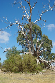 Greensborough Historical Society
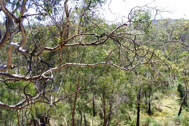
Photograph - Digital image, Marilyn Smith et al, Janefield Precinct: dead gum tree and box thorns, 27/11/2014
... The remains of this site are between Greensborough and Janefield. A RAAF Hygiene Training Camp was located on the Plenty River, just south of the Janefield community. ...Camp was constructed from salvaged materials. Instruction included building and maintenance of grease traps, latrines, elementary plumbing and carpentry. Early remains ...Janefield Precinct: dead gum tree and box thorns. The remains of this site are between Greensborough and Janefield. A RAAF Hygiene Training Camp was located on the Plenty River, just south of the Janefield community. It was in use from 1944 to 1946. The Camp was constructed from salvaged materials. Instruction included building and maintenance of grease traps, latrines, elementary plumbing and carpentry.Early remains of a WW2 training campDigital colour photograph.janefield, raaf hygiene training camp janefield -
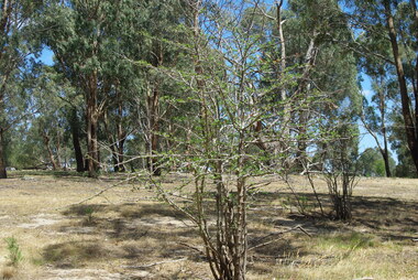
 Greensborough Historical Society
Photograph - Digital image, Marilyn Smith et al, Janefield Precinct: gumtree, 27/11/2014
... The remains of this site are between Greensborough and Janefield. A RAAF Hygiene Training Camp was located on the Plenty River, just south of the Janefield community. ...Camp was constructed from salvaged materials. Instruction included building and maintenance of grease traps, latrines, elementary plumbing and carpentry. Early remains ...Janefield Precinct: gum tree. The remains of this site are between Greensborough and Janefield. A RAAF Hygiene Training Camp was located on the Plenty River, just south of the Janefield community. It was in use from 1944 to 1946. The Camp was constructed from salvaged materials. Instruction included building and maintenance of grease traps, latrines, elementary plumbing and carpentry.Early remains of a WW2 training campDigital colour photograph.janefield -
 Greensborough Historical Society
Photograph - Digital image, Marilyn Smith et al, Janefield Precinct: hawthorn trees, 27/11/2014
... The remains of this site are between Greensborough and Janefield. A RAAF Hygiene Training Camp was located on the Plenty River, just south of the Janefield community. ...Camp was constructed from salvaged materials. Instruction included building and maintenance of grease traps, latrines, elementary plumbing and carpentry. Early remains ...Janefield Precinct: hawthorn trees. The remains of this site are between Greensborough and Janefield. A RAAF Hygiene Training Camp was located on the Plenty River, just south of the Janefield community. It was in use from 1944 to 1946. The Camp was constructed from salvaged materials. Instruction included building and maintenance of grease traps, latrines, elementary plumbing and carpentry.Early remains of a WW2 training campDigital colour photograph.janefield, raaf hygiene training camp janefield -
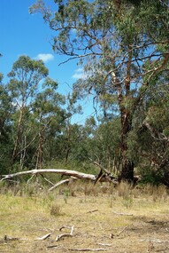
 Greensborough Historical Society
Photograph - Digital image, Marilyn Smith et al, Janefield Precinct view November 2014, 27/11/2014
... The remains of this site are between Greensborough and Janefield. A RAAF Hygiene Training Camp was located on the Plenty River, just south of the Janefield community. ...Camp was constructed from salvaged materials. Instruction included building and maintenance of grease traps, latrines, elementary plumbing and carpentry. Early remains ...View of the Janefield Precinct taken November 2014. The remains of this site are between Greensborough and Janefield. A RAAF Hygiene Training Camp was located on the Plenty River, just south of the Janefield community. It was in use from 1944 to 1946. The Camp was constructed from salvaged materials. Instruction included building and maintenance of grease traps, latrines, elementary plumbing and carpentry.Early remains of a WW2 training campDigital colour photograph.janefield, raaf hygiene training camp janefield -
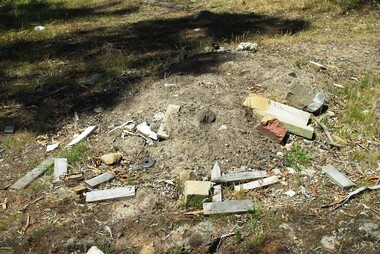 Greensborough Historical Society
Photograph - Digital image, Marilyn Smith et al, Janefield Precinct: junk left by surveyors, 27/11/2014
... The remains of this site are between Greensborough and Janefield. A RAAF Hygiene Training Camp was located on the Plenty River, just south of the Janefield community. ...Camp was constructed from salvaged materials. Instruction included building and maintenance of grease traps, latrines, elementary plumbing and carpentry. Early remains ...Junk left by surveyors. The remains of this site are between Greensborough and Janefield. A RAAF Hygiene Training Camp was located on the Plenty River, just south of the Janefield community. It was in use from 1944 to 1946. The Camp was constructed from salvaged materials. Instruction included building and maintenance of grease traps, latrines, elementary plumbing and carpentry.Early remains of a WW2 training camp Digital colour photograph.janefield, raaf hygiene training camp janefield -
 Greensborough Historical Society
Photograph - Digital image, Marilyn Smith et al, Janefield Precinct: Looking down toward Kookaburra Bend 1, 27/11/2014
... The remains of this site are between Greensborough and Janefield. A RAAF Hygiene Training Camp was located on the Plenty River, just south of the Janefield community. ...Camp was constructed from salvaged materials. Instruction included building and maintenance of grease traps, latrines, elementary plumbing and carpentry. Early remains ...Looking down toward Kookaburra Bend 1. The remains of this site are between Greensborough and Janefield. A RAAF Hygiene Training Camp was located on the Plenty River, just south of the Janefield community. It was in use from 1944 to 1946. The Camp was constructed from salvaged materials. Instruction included building and maintenance of grease traps, latrines, elementary plumbing and carpentry.Early remains of a WW2 training camp Digital colour photograph.