Showing 4 items matching "camperdown avenue"
-
 Sunshine and District Historical Society Incorporated
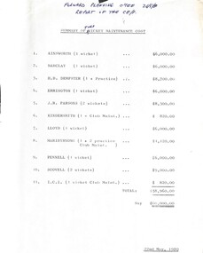
Administrative record - City of Sunshine - Commissioner Mr Alexander Alex George Gillon Collection 1976 - 1982 - Summary Of Turf Wicket Maintenance Cost 1980, City of Sunshine, 22nd May 1980
... ...Camperdown Avenue...Albans Parsons Reserve Stanford Street Sunshine Kindersmith Reserve Lily Street Braybrook Lloyd Reserve Camperdown Avenue Maribyrnong Reserve Hortense Street Maribyrnong Pennell Reserve Burke Street Scovell Reserve Scovell Crescent Maidstone ICI Ground Deer Park Oval John McLeod Reserve Ballarat Road Deer Park Summary of Turf Wicket Maintenance Cost Ainsworth Reserve Barclay Reserve H. ...Summary of Turf Wicket Maintenance Cost Ainsworth Reserve Barclay Reserve H. B. Dempster Reserve Errington Reserve J. R. Parsons Reserve Kindersmith Reserve Lloyd Reserve Maribyrnong Reserve Pennell Reserve Scovell Reserve ICI Ground (Deer Park Reserve now John McLeod Reserve)ainsworth reserve, vernon crescent, barclay reserve, king edward avenue, albion, dempster reserve, phoenix street, sunshine north, errington reserve, main road east, st. albans, parsons reserve, stanford street, sunshine, kindersmith reserve, lily street, braybrook, lloyd reserve, camperdown avenue, maribyrnong reserve, hortense street, maribyrnong, pennell reserve, burke street, scovell reserve, scovell crescent, maidstone, ici ground, deer park oval, john mcleod reserve, ballarat road, deer park -
 Sunshine and District Historical Society Incorporated
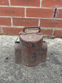
Functional object - M.M.B.W. Water Meter Cover
... This meter cover was founded at abandon house in Camperdown Avenue Sunshine North...This meter cover was founded at abandon house in Camperdown Avenue Sunshine North MMBW 3/4 Cast iron water meter cover Functional object M.M.B.W. ...Cast iron water meter covers were commonly used in the late 19th & early 20th centuries to protect water meters from damage and the elements. These covers were typically made of heacy cast iron to withstand the rigors of outdoor use and prevent tampering. The design often included a handle for easy removal and replacement by the meter reader. This meter cover was founded at abandon house in Camperdown Avenue Sunshine NorthCast iron water meter coverMMBW 3/4 -
 Uniting Church Archives - Synod of Victoria
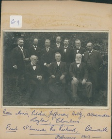
photograph, Brighton Congregational Church deacons, February 1903
... Camperdown/Glebe. Trained at Wesley in Adelaide (Methodist background). Established Congregational churches at Black Rock, Roseberry Avenue Brighton....Camperdown/Glebe. Trained at Wesley in Adelaide (Methodist background). Established Congregational churches at Black Rock, Roseberry Avenue Brighton. ...The minister of Brighton Congregational Church was the Rev. James E. Rickard, who was born in Cornwall in February 1850 and died in Surrey Hills on 25 January 1909. His congregations were Camberdown/Glebe in NSW, Black Street Brighton (1885–1907) and Wyclif Surrey Hills (1907–09). Chairman of the CUV 1891–92, Lecturer at Camden College in NSW while minister at Camperdown/Glebe. Trained at Wesley in Adelaide (Methodist background). Established Congregational churches at Black Rock, Roseberry Avenue Brighton.B & W photograph of 10 men seated and standing outdoors, mounted on buff card. The names of the 10 men have been handwritten below the photograph on the card mount: Rear: Morris, Pitcher, Jefferson, Holtz, Alexander, Laylor, Chambers. Front: S.P. Simmonds, Rev. Rickard, Blundell February 1903 brighton congregational church, rev. james e. rickard, black street -
 Kew Historical Society Inc
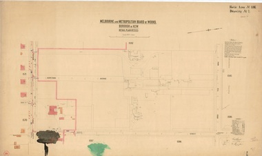
Plan, Melbourne & Metropolitan Board of Works / Borough of Kew, Detail Plan No.1593, 1905
... Avenue in 1916. The most notable occupant of Clifton was William Adeney [died 1893], a pioneer of Camperdown, after which Park Street was later renamed....Avenue in 1916. The most notable occupant of Clifton was William Adeney [died 1893], a pioneer of Camperdown, after which Park Street was later renamed. ...The Melbourne and Metropolitan Board of Works (MMBW) plans were produced from the 1890s to the 1950s. They were crucial to the design and development of Melbourne's sewerage and drainage system. The plans, at a scale of 40 feet to 1 inch (1:480), provide a detailed historical record of Melbourne streetscapes and environmental features. Each plan covers one or two street blocks (roughly six streets), showing details of buildings, including garden layouts and ownership boundaries, and features such as laneways, drains, bridges, parks, municipal boundaries and other prominent landmarks as they existed at the time each plan was produced. (Source: State Library of Victoria)This plan forms part of a large group of MMBW plans and maps that was donated to the Society by the Mr Poulter, City Engineer of the City of Kew in 1989. Within this collection, thirty-five hand-coloured plans, backed with linen, are of statewide significance as they include annotations that provide details of construction materials used in buildings in the first decade of the 20th century as well as additional information about land ownership and usage. The copies in the Public Record Office Victoria and the State Library of Victoria are monochrome versions which do not denote building materials so that the maps in this collection are invaluable and unique tools for researchers and heritage consultants. A number of the plans are not held in the collection of the State Library of Victoria so they have the additional attribute of rarity.Original survey plan, issued by the MMBW to a contractor with responsibility for constructing sewers in the area identified on the plan within the Borough of Kew. The plan was at some stage hand-coloured, possibly by the contractor, but more likely by officers working in the Engineering Department of the Borough and later Town, then City of Kew. The hand-coloured sections of buildings on the plan were used to denote masonry or brick constructions (pink), weatherboard constructions (yellow), and public buildings (grey). The laborious task of hand-tinting these Board of Works plans was not without hazards as is evidenced by Plan No. 1593. On the Plan, the original colourist spilt black and green ink, partially obscuring some parts. The most obvious casualty is ‘Clifton’ located on the corner of Cotham Road and Park Street [now Adeney Avenue]. Included in this Plan, and outlined in pink is that part of the section that the contracting engineer was tasked with completing. This included sewering on both sides of this part of Cotham Road, but excluded properties such as ‘Glendonald’ and ‘Monnington’. This area was to undergo a series of subdivisions including the ‘Clifton Estate’, which created housing lots on Adeney Avenue and Florence Avenue in 1916. The most notable occupant of Clifton was William Adeney [died 1893], a pioneer of Camperdown, after which Park Street was later renamed.melbourne and metropolitan board of works, detail plans, survey plans - borough of kew, mmbw 1593, cartography