Showing 30 items matching "cardinia shire"
-
 Narre Warren and District Family History Group
Book, Graeme Butler & Associates, Cardinia Shire Heritage Study Vol 1 : Heritage Program Vol 2 : Environmental History Vol 3 : Heritage Places, 1996
... Cardinia Shire Heritage Study Vol 1 : Heritage Program Vol 2 : Environmental History Vol 3 : Heritage Places...Cardinia Shire (Vic.)...Cardinia Shire (Vic.) heritage studies Vol 1 : Heritage program, identification and restoration of homes, gardens and commercial buildings in the Shire. ...Vol 1 : Heritage program, identification and restoration of homes, gardens and commercial buildings in the Shire. Vol 2 : Exploration of historical themes - Aboriginal heritage, Explorers and first contact, Pastoralists and farmers, Extractive industries, Secondary Industries, Transport, Resorts and recreation, Village townships, Towns as district service centres, Housing and it's setting, Notable district residents, Natural disasters and their effects, and Cultural landscape. Vol 3 : Detailed citations for 150 sites in the Cardinia Shire, focusing on those from the previous Shires of Pakenham and Cranbourne.non-fictionVol 1 : Heritage program, identification and restoration of homes, gardens and commercial buildings in the Shire. Vol 2 : Exploration of historical themes - Aboriginal heritage, Explorers and first contact, Pastoralists and farmers, Extractive industries, Secondary Industries, Transport, Resorts and recreation, Village townships, Towns as district service centres, Housing and it's setting, Notable district residents, Natural disasters and their effects, and Cultural landscape. Vol 3 : Detailed citations for 150 sites in the Cardinia Shire, focusing on those from the previous Shires of Pakenham and Cranbourne.cardinia shire (vic.), heritage studies -
 Narre Warren and District Family History Group
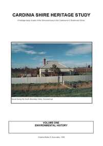
Book, Graeme Butler & Associates, Cardinia Shire Heritage Study : a heritage study of parts of the Shire previously in the Cranbourne & Sherbrooke Shires. Vol 1 : Key Findings and Recommendations Vol 2 : Heritage Place and Precinct Citations, 1998
... Cardinia Shire Heritage Study : a heritage study of parts of the Shire previously in the Cranbourne & Sherbrooke Shires. ...Cardinia Shire (Vic.)...[from the introduction] Cardinia Shire Heritage Study : a heritage study of parts of the Shire previously in the Cranbourne & Sherbrooke Shires. ...This Environmental History of the Cardinia Shire incorporates the Environmental History of the former Shire of Pakenham, compiled by Carlotta Kellaway for Graeme Butler & Associates and the Environmental History of those areas of the Shire formerly in the Shires of Cranbourne and Sherbrooke, compiled by Jill Barnard for Graeme Butler and Associates. An environmental history, which is meant as a guide to the identification of sites of significance within a shire, cannot be a complete social history of that shire. Rather, it is meant to be a summary of the various ways in which people have used and reacted to the natural environment, altering it so as to create economic, social, cultural and educational uses for themselves and their neighbours. [from the introduction]non-fictionThis Environmental History of the Cardinia Shire incorporates the Environmental History of the former Shire of Pakenham, compiled by Carlotta Kellaway for Graeme Butler & Associates and the Environmental History of those areas of the Shire formerly in the Shires of Cranbourne and Sherbrooke, compiled by Jill Barnard for Graeme Butler and Associates. An environmental history, which is meant as a guide to the identification of sites of significance within a shire, cannot be a complete social history of that shire. Rather, it is meant to be a summary of the various ways in which people have used and reacted to the natural environment, altering it so as to create economic, social, cultural and educational uses for themselves and their neighbours. [from the introduction] cardinia shire (vic.), heritage studies, tivoli berry farm (clematis), carramar (emerald), nobelius heritage park, dalmore public hall, horace hardy farm complex, emerald lake park, the grange (koo wee rup), glen afton (yannathan), myrtlewood (yannathan), vay view farm (lang lang), emerald railway station, timber bridges (yallock creek), emerald county clud, oak lee (emerald), sycamore lodge (emerald), cambden wollybutt row (emerald), silver birches (emerald), lang lang cemetery, old monomeith homestead sites, monomeith park (monomeith), dustings garage (koo wee rup), koo wee rup public hall, koo wee rup lockup, wattle theatre (koo wee rup), harewood (koo wee rup), warook homestead (monomeith), old yallock, st john's roman catholic church (koo wee rup), royal hotel (koo wee rup), budgeree (yannathan), cascades guest house (clematis), rutter farm (tooradin), koo wee rup swamp drains, upper ferntree gully to gembrook railway, great southern railway, misson's butchers shop & residence (lang lang), english scottish & australian bank (lang lang), clematis park, row houses (lang lang) -
 Emerald Museum & Nobelius Heritage Park
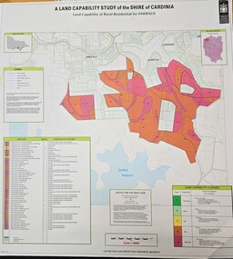
Map - Land Capability Study of the Shire of Cardinia - Rural residential Emerald 1996, c1996
... Land Capability Study of the Shire of Cardinia - Rural residential Emerald 1996...Land Capability Study of the Shire of Cardinia - Rural residential Emerald 1996...Image of a map indicating capability study of the Shire of Cardinia - Rural residential Emerald...A Land Capability Study of the Shire of Cardinia/Land Capability of Rural residential or Emerald/Centro for land protection research, Bendigo/Legen x 3/Land Capability Classes - 1 to 5...Emerald Museum & Nobelius Heritage Park 5 Crichton Rd Emerald yarra-valley-and-the-dandenong-ranges A Land Capability Study of the Shire of Cardinia/Land Capability of Rural residential or Emerald/Centro for land protection research, Bendigo/Legen x 3/Land Capability Classes - 1 to 5 Image of a map indicating capability study of the Shire of Cardinia - Rural residential Emerald Land Capability Study of the Shire of Cardinia - Rural residential Emerald 1996 Map Land Capability Study of the Shire of Cardinia - Rural residential Emerald 1996 ...Image of a map indicating capability study of the Shire of Cardinia - Rural residential EmeraldA Land Capability Study of the Shire of Cardinia/Land Capability of Rural residential or Emerald/Centro for land protection research, Bendigo/Legen x 3/Land Capability Classes - 1 to 5 -
 Emerald Museum & Nobelius Heritage Park
Map - Land Capability Study of the Shire of Cardinia, parish of Emerald, c1996
... Land Capability Study of the Shire of Cardinia, parish of Emerald...Land Capability Study of the Shire of Cardinia, parish of Emerald...Image of a land capability study map in the Shire of Cardinia, parish Parcels of Emerald...A land Capability Study of the Shire of Cardinia/Map Units and Parish parcels of Emerald/C1996...Emerald Museum & Nobelius Heritage Park 5 Crichton Rd Emerald yarra-valley-and-the-dandenong-ranges A land Capability Study of the Shire of Cardinia/Map Units and Parish parcels of Emerald/C1996 Image of a land capability study map in the Shire of Cardinia, parish Parcels of Emerald Land Capability Study of the Shire of Cardinia, parish of Emerald Map Land Capability Study of the Shire of Cardinia, parish of Emerald ...Image of a land capability study map in the Shire of Cardinia, parish Parcels of EmeraldA land Capability Study of the Shire of Cardinia/Map Units and Parish parcels of Emerald/C1996 -
 MYLI My Community Library
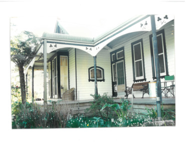
Photograph - Villa Maria exterior verandah, Unknown
... ...Cardinia Shire...27 O'Neil Road, Beaconsfield, Cardinia Shire, Victoria, Australia...Villa Maria Villa Mar Architecture Catholic Church Beaconsfield Cardinia Shire N/A Colour rectangular photograph developed on matte photographic paper. ...Villa Maria, later known as Villa Mar has a close association with the Catholic Church, with identifiable and notable Catholic attributes such as the inner courtyard and chapel on the villa. It also is symbolic of a rural retreat which the Beaconsfield area was once noted for.This house is a symbolic representation of the Federation Bungalow architectural style, with influences of catholic attributes.Colour rectangular photograph developed on matte photographic paper. N/Avilla maria, villa mar, architecture, catholic church, beaconsfield, cardinia shire -
 Narre Warren and District Family History Group
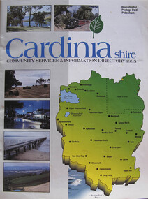
Booklet, Cardinia Shire Community Services and Information Directory 1995
... Cardinia Shire Community Services and Information Directory 1995...Shire of Cardinia...This directory has been complied as an easy reference guide for all Shire of Cardinia local Council and Community services, groups and facilities....Cardinia Shire Community Services and Information Directory 1995 Booklet ...Cover has a map of the shire with six small photos of places in the Shire. This directory has been complied as an easy reference guide for all Shire of Cardinia local Council and Community services, groups and facilities.shire of cardinia, bernard coburn, pamela jones, john raymond, jim stevenson -
 MYLI My Community Library
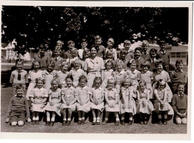
Photograph - Pakenham Consolidated School Grade Two Class Photo, 1953
... Main Street, Pakenham, Cardinia Shire, Victoria, Australia...The photograph is also of social significance to many community groups, including Cardinia Shire, past and current students and teachers, allowing various groups to reflect on and share intangible memories of times spent at Pakenham Consolidated School. ...Grade 2 of Pakenham Consolidated School in 1953 with their teacher Mrs Joyce Hosking. Back row L to R: Paul Manestar or Bill Vallender, Bernie Carter, (?), Norman Whitelaw, Richard Shelton, Rodney Shallard, Ian Reid (Reidy?) or Duncan Beard (Reidy), Ken Jarred, Glen Jolly. 2nd back row L to R: Keith Crofts, Peter Johnstone, Kevin Lewis, Robert Tulloch (Bones), Nipper Reid, Duncan Beard(?), Bruce Weatherhead, Peter Hobson (Hobbo). 2nd row from front L to R: David Langley, Kath Mauger, Jill Peck, Rosamund Hunt, Beth Schilling, Roslyn Smith, Lynne Tuena, Pat Stone, Joy Higgins, Lynette Wheeler, Grif Fearon or Kevin McInnis. Front row L to R: Ken McCaffrey, Marion Butcher, Helen Stephens, Mary Lou Walsh, Glenis Tuena, Dawn Hillderbrick/ Hillbrick(?), Marion Hansford, Kaye Wollard, Beverley Payne (Payney), Edna Sinclair(?), Paul Braemar. In the 1940s and 1950s there was a movement to consolidate small rural schools into one larger school. This was partly a response to a shortage of teachers, due to many male teachers enlisting during the Second World War. The War also caused a shortage of materials and labour and many Schools fell into disrepair. The Education Department decided that Pakenham would be one of the first six Consolidated Schools to be established and that all schools within 8 kms or 5 miles would be closed. The Pakenham Consolidated School was officially opened on May 29, 1951, on the site of the Pakenham State School, No.1359, in Main Street. The original Pakenham School had opened on a site near the Toomuc Creek in January 1875 and it moved to the Main Street site in 1891. The first Head Master was Charles Hicks. The School offered classes up to Year 10 (Form 4). The schools that formed the Consolidated School were Pakenham Upper No. 2155 (closed January 1952), Pakenham South No. 3755 (closed September 1951), Toomuc Valley No. 3034 (closed September 1951), Army Road No. 3847 (closed April 1947), Mount Burnett No. 4506 (closed October 1949), Tynong No. 2854 (closed April 1951), Tynong North No.4464 (closed December 1951), Nar Nar Goon North No. 2914 (closed October 1951), Nar Nar Goon South No. 4554 (closed May 1951), Rythdale No. 4231 (closed September 1951), Officedale No. 4242 (closed May 1951), Cora Lynn No. 3502 (closed May 1951) and Koo-Wee-Rup North (Five Mile) No. 3198 (closed November 1959). The School consisted of new buildings, which at the time cost one hundred thousand pounds, and many of the old School buildings. Some towns did not realise that their School buildings would be removed from the sites and transferred to Pakenham. The Pakenham Consolidated School moved from its original location in Main Street to its current location in Rundell, Way in 1997.This photograph is of historic and social significance. Pakenham Consolidated School was one of the first six Consolidated Schools established by the Education Department, and was born out of shortages of teachers, labour, and materials during World War II. The school can be used more broadly to reflect on the evolution of education in the state of Victoria, as the school can trace its origins all the way back to 1875, when the original Pakenham School was opened near Toomuc Creek. The photograph is also of social significance to many community groups, including Cardinia Shire, past and current students and teachers, allowing various groups to reflect on and share intangible memories of times spent at Pakenham Consolidated School.Copy of a rectangular black and white photograph on matte photographic paperpakenham consolidated school, primary school, class photo, grade two, grade 2, pakenham, school, photo -
 Narre Warren and District Family History Group
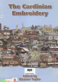
Book, Eleanor Taylor, The Cardinian embroidery, 2006
... Cardinia Shire (Vic.)...Narre Warren and District Family History Group 110 High Street Berwick melbourne Cardinia Shire (Vic.) Embroidery The Cardinian Embroidery uses fabric, thread and the ancient art of stitching to depict the heritage and traditions of the Cardinia Shire as viewed in 2005. ...The Cardinian Embroidery uses fabric, thread and the ancient art of stitching to depict the heritage and traditions of the Cardinia Shire as viewed in 2005. There are eight panels depicting 384 features of local significance. A brief historical note accompanies each feature. The individual textile artists are also listed.iv, 68 p.; 30 cmnon-fictionThe Cardinian Embroidery uses fabric, thread and the ancient art of stitching to depict the heritage and traditions of the Cardinia Shire as viewed in 2005. There are eight panels depicting 384 features of local significance. A brief historical note accompanies each feature. The individual textile artists are also listed. cardinia shire (vic.), embroidery -
 Narre Warren and District Family History Group
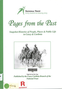
Book, National Trust of Australia (Victoria). Casey-Cardinia Branch, Pages from the Past. Snapshot Histories of People, Places & Public Life in Casey & Cardinia, 2011
... ...Cardinia Shire (Vic.)...Narre Warren and District Family History Group 110 High Street Berwick melbourne City of Casey Cardinia Shire (Vic.) Contents include: Richard Gavin Gardiner Casey [Edrington]; The Police Paddocks and the Native Police Corps; The changing face of Berwick township; Coaches, tolls and local councils; Berwick Mechanics Institute and Free Library; Berwick Primary School [No. 40] and Berwick Grammar School; A century of quarrying in Berwick; The German settlement of Harkaway; Emerald’s first State School No. 2110 (1879-1909); The railway to Gippsland; Early sawmilling in West Gippsland; Tooradin and the coastal villages; Some notable early residents and their homes; The draining of the Koo-Wee-Rup swamp; Guest houses at Upper Beaconsfield; Ada Armytage of Holm Park; The soldiers of early Berwick; Memorials, commemorations and avenues of honour; Bush nursing hospitals; The Melbourne Hunt Club [The "Kennels" at Cranbourne]; Growing up in Berwick in the 1930s & 1940s; Growing up in Beaconsfield in the 1930s and 1940s; Casey Airfield; The history of Maryknoll [Catholic farming community]; The filming of “On the beach”; Memories of Ash Wednesday; Maps of the Casey-Cardinia area. ...Contents include: Richard Gavin Gardiner Casey [Edrington]; The Police Paddocks and the Native Police Corps; The changing face of Berwick township; Coaches, tolls and local councils; Berwick Mechanics Institute and Free Library; Berwick Primary School [No. 40] and Berwick Grammar School; A century of quarrying in Berwick; The German settlement of Harkaway; Emerald’s first State School No. 2110 (1879-1909); The railway to Gippsland; Early sawmilling in West Gippsland; Tooradin and the coastal villages; Some notable early residents and their homes; The draining of the Koo-Wee-Rup swamp; Guest houses at Upper Beaconsfield; Ada Armytage of Holm Park; The soldiers of early Berwick; Memorials, commemorations and avenues of honour; Bush nursing hospitals; The Melbourne Hunt Club [The "Kennels" at Cranbourne]; Growing up in Berwick in the 1930s & 1940s; Growing up in Beaconsfield in the 1930s and 1940s; Casey Airfield; The history of Maryknoll [Catholic farming community]; The filming of “On the beach”; Memories of Ash Wednesday; Maps of the Casey-Cardinia area. Notable people : William Lyall and "Harewood'; William Clarke and "Springfield'; Sydney Webb and "Holly Green"; Carl Axel Nobelius; Edwin Flack and "Burnbank"; Carlo Catani;. Includes illustrations, portraits, photographs, maps and bibliography.106 p. : ill., portraits, map, bib., pbk ; 30 cmnon-fictionContents include: Richard Gavin Gardiner Casey [Edrington]; The Police Paddocks and the Native Police Corps; The changing face of Berwick township; Coaches, tolls and local councils; Berwick Mechanics Institute and Free Library; Berwick Primary School [No. 40] and Berwick Grammar School; A century of quarrying in Berwick; The German settlement of Harkaway; Emerald’s first State School No. 2110 (1879-1909); The railway to Gippsland; Early sawmilling in West Gippsland; Tooradin and the coastal villages; Some notable early residents and their homes; The draining of the Koo-Wee-Rup swamp; Guest houses at Upper Beaconsfield; Ada Armytage of Holm Park; The soldiers of early Berwick; Memorials, commemorations and avenues of honour; Bush nursing hospitals; The Melbourne Hunt Club [The "Kennels" at Cranbourne]; Growing up in Berwick in the 1930s & 1940s; Growing up in Beaconsfield in the 1930s and 1940s; Casey Airfield; The history of Maryknoll [Catholic farming community]; The filming of “On the beach”; Memories of Ash Wednesday; Maps of the Casey-Cardinia area. Notable people : William Lyall and "Harewood'; William Clarke and "Springfield'; Sydney Webb and "Holly Green"; Carl Axel Nobelius; Edwin Flack and "Burnbank"; Carlo Catani;. Includes illustrations, portraits, photographs, maps and bibliography. city of casey, cardinia shire (vic.) -
 MYLI My Community Library
Photograph - Villa Maria exterior
... ...Cardinia Shire...Beaconsfield Cardinia Shire Villa Maria Villa Mar Architecture Catholic Church N/A Colour rectangular photograph developed on matte photographic paper. ...Villa Maria, later known as Villa Mar has a close association with the Catholic Church, with identifiable and notable Catholic attributes such as the inner courtyard and chapel on the villa. It also is symbolic of a rural retreat which the Beaconsfield area was once noted for.This house is a symbolic representation of the Federation Bungalow architectural style, with influences of catholic attributes.Colour rectangular photograph developed on matte photographic paper.N/Abeaconsfield, cardinia shire, villa maria, villa mar, architecture, catholic church -
 Narre Warren and District Family History Group
Book, Context Pty Ltd, Cardinia Local Heritage Study Review 2007 Stage A. Vol 1 : Key Findings And Recommendations Vol 2 : Heritage Place And Precinct Citations, 2007
... Cardinia Shire (Vic.)...Pre-emptive Right Homestead site (Pakenham) Valley View Orchards Manager's House (Pakenham Upper) Ruthdale Reserve Trees Rutter Farm Trees (Tooradin) Eve's House (Tynong North) Kia Ora (Upper Beaconsfield) The Steyne (Upper Beaconsfield) Beaconsfield Upper Milk Bar Staverton Garden (Upper Beaconsfield) Great Southern Railway The overall objective of the Study was the identification, assessment and documentation of places of post-contact cultural significance for the Cardinia Shire. Cardinia Local Heritage Study Review 2007 Stage A. ...The overall objective of the Study was the identification, assessment and documentation of places of post-contact cultural significance for the Cardinia Shire.non-fictionThe overall objective of the Study was the identification, assessment and documentation of places of post-contact cultural significance for the Cardinia Shire.cardinia shire (vic.), heritage studies, kenilworth coach house (beaconsfield), wood street residential precinct (beaconsfield), george street residential precinct (bunyip), bunyip post office, railway hotel (bunyip), cora lynn catholic parish school, glen-keith farm complex (dalmore), emerald lake park, emerald railway station, emerald country club, cambden woolybutt ros (emerald), oak lee (emerald), sycamore lodge (emerald), cascades guest house, orchard packing shed (garfield north), wattle bank (gembrook), coffee palace (gembrook), tehennepe (iona), koo wee rup public hall, dustings garage (koo wee rup), wattle theatre (koo wee rup), koo wee rup police lockup, royal hotel (koo wee rup), lang lang cemetery, misson's butchers shop & residence (lang lang), anz bank (lang lang), maryknoll residential & civic precinct, maryknoll lawn cemetery, mount burnett guesthouse, oakway (nar nar goon), nar nar goon growers & packers shed, jesmond dene (officer south), kings picture theatre (pakenham), pakenham post office, i.y.u. pre-emptive right homestead site (pakenham), valley view orchards manager's house (pakenham upper), ruthdale reserve trees, rutter farm trees (tooradin), eve's house (tynong north), kia ora (upper beaconsfield), the steyne (upper beaconsfield), beaconsfield upper milk bar, staverton garden (upper beaconsfield), great southern railway -
 Narre Warren and District Family History Group
Book, Heritage Branch Ministry for Planning and Environment, Architectural survey of the Berwick-Pakenham corridor : a report prepared by the Heritage Branch, Ministry for Planning and Environment, 1989
... ...Cardinia Shire (Vic.)...Its spine is the Princes Highway, along which it extends for the full 44 kilometres from west to east. heritage studies Cardinia Shire (Vic.) City of Casey (Vic.) This survey was undertaken as a seven week project commissioned by the Heritage Branch, Ministry for Planning and Environment. ...This survey was undertaken as a seven week project commissioned by the Heritage Branch, Ministry for Planning and Environment. The parameters of the brief were to locate buildings or sites of architectural or historical significance in the Berwick-Pakenham Corridor. [from intro.] Downloaded from: https://vgls.sdp.sirsidynix.net.au/client/search/asset/1268608non-fictionThis survey was undertaken as a seven week project commissioned by the Heritage Branch, Ministry for Planning and Environment. The parameters of the brief were to locate buildings or sites of architectural or historical significance in the Berwick-Pakenham Corridor. [from intro.] Downloaded from: https://vgls.sdp.sirsidynix.net.au/client/search/asset/1268608heritage studies, cardinia shire (vic.), city of casey (vic.) -
Save the Dandenongs League Inc.
Document (item), Save the Dandenongs League Incorporated, Correspondence June July 1997 to 1998 July/Aug - S.D.L. [Part 7 of 10]: City of Knox - Shire of Cardinia
... [Part 7 of 10]: City of Knox - Shire of Cardinia...[Part 7 of 10]: City of Knox - Shire of Cardinia Document Save the Dandenongs League Incorporated ... -
Save the Dandenongs League Inc.
Document (item), Save the Dandenongs League Incorporated, Correspondence - Save the Dandenongs League Inc. - June 95-July 96 [Part 7 of 10]: City of Knox - Shire of Cardinia
... . - June 95-July 96 [Part 7 of 10]: City of Knox - Shire of Cardinia.... - June 95-July 96 [Part 7 of 10]: City of Knox - Shire of Cardinia Document Save the Dandenongs League Incorporated ... -
Save the Dandenongs League Inc.
Document (item), Save the Dandenongs League Incorporated, Correspondence S.D.L. - July '96 to June '97 [Part 5 of 8]: City of Knox - Shire of Cardinia
... . - July '96 to June '97 [Part 5 of 8]: City of Knox - Shire of Cardinia.... - July '96 to June '97 [Part 5 of 8]: City of Knox - Shire of Cardinia Document Save the Dandenongs League Incorporated ... -
MYLI My Community Library
Map - Nar Nar Goon County of Mornington Map, 1944, H.E Daw - Government Printer, June 1944
... This was a map made in the period before Cardinia shire was created in 1994. ...John & Henry Street Pakenham melbourne This was a map made in the period before Cardinia shire was created in 1994. With intricate labelling of lot allocations, this map is a invaluable research potential for understanding the settlement of the area and its development in the first half of the 1900s. ...This was a map made in the period before Cardinia shire was created in 1994. With intricate labelling of lot allocations, this map is a invaluable research potential for understanding the settlement of the area and its development in the first half of the 1900s. A paper map with yellow shaded areas and black ink.On Left Side: Pakenham (lot numbers throughout the map) Top side: Gembrook, Tonimbuk Right Side: Bunyip, Koo-wee-rup East Bottom Side: By Authority: / H.E. Daw Government Printer / Melbourne Koo-wee-rup Bottom Right Corner: NOTE: The allotments colored brown are freehold. In respect of which the name. The Area, and the Date where given, are the particulars set out in the Crown grant as issued by the Lands Department. / After the issue of the Crown Grant, all subsequent dealings are effected at the office of titles, Queen Street, Melbourne, and particulars as to present registered ownership, boundaries, subdivisions, etc., may be obtained by search at that office. / This plan has been compiled from the Lands Department Record as at June 1944 / Nar-Nar-Goon / County of Mornington / Drawn and reproduced at the department of lands and survey, Melbourne Price 2/. June 1944 h.e. daw, map, nar-nar-goon, county of mornington, pakenham, koo-wee-rup -
 Emerald Museum & Nobelius Heritage Park
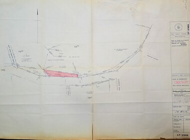
Map - Surveyors map of Wellington Rd. near Magpie Rd., and Paradise Rd., Clematis, Part of Crown allotments 106E and 106G2, survey map of Wellington Rd., near Magpie Rd. and Paradise Rd., Clematis 1972, c1972
... Title Survey Division/Crown Description/Part of Crown Allotments 106F2 and 106G1/Parish of Narree Worran, County of Mornington/Cardinia/Shire of Sherbrooke, Wellington Road/Rossley Paul Gardiner of Kirkpatrick & Webber, 289 Maroondah Hwy, Ringwood/Signed S.R. ...Emerald Museum & Nobelius Heritage Park 5 Crichton Rd Emerald yarra-valley-and-the-dandenong-ranges Title Survey Division/Crown Description/Part of Crown Allotments 106F2 and 106G1/Parish of Narree Worran, County of Mornington/Cardinia/Shire of Sherbrooke, Wellington Road/Rossley Paul Gardiner of Kirkpatrick & Webber, 289 Maroondah Hwy, Ringwood/Signed S.R. ...Image of Surveyors map outlining part of Wellington Rd., Near Magpie Rd. and Paradise Rd., Clematis 1972Title Survey Division/Crown Description/Part of Crown Allotments 106F2 and 106G1/Parish of Narree Worran, County of Mornington/Cardinia/Shire of Sherbrooke, Wellington Road/Rossley Paul Gardiner of Kirkpatrick & Webber, 289 Maroondah Hwy, Ringwood/Signed S.R. Clarke 21.6.72 -
 Emerald Museum & Nobelius Heritage Park
Map - Surveyors map of Wellington Rd. near Magpie Rd., and Paradise Rd., Clematis, Part of Crown allotments 106F2 and 106G1, survey map of Wellington Rd., near Magpie Rd. and Paradise Rd., Clematis 1972, c1972
... Title Survey Division/Crown Description/Part of Crown Allotments 106F2 and 106G1/Parish of Narree Worran, County of Mornington/Cardinia/Shire of Sherbrooke, Wellington Road/Rossley Paul Gardiner of Kirkpatrick & Webber, 289 Maroondah Hwy, Ringwood/Signed S.R. ...Emerald Museum & Nobelius Heritage Park 5 Crichton Rd Emerald yarra-valley-and-the-dandenong-ranges Title Survey Division/Crown Description/Part of Crown Allotments 106F2 and 106G1/Parish of Narree Worran, County of Mornington/Cardinia/Shire of Sherbrooke, Wellington Road/Rossley Paul Gardiner of Kirkpatrick & Webber, 289 Maroondah Hwy, Ringwood/Signed S.R. ...Image of Surveyors map outlining part of Wellington Rd., Near Magpie Rd. and Paradise Rd., Clematis 1972Title Survey Division/Crown Description/Part of Crown Allotments 106F2 and 106G1/Parish of Narree Worran, County of Mornington/Cardinia/Shire of Sherbrooke, Wellington Road/Rossley Paul Gardiner of Kirkpatrick & Webber, 289 Maroondah Hwy, Ringwood/Signed S.R. Clarke 21.6.72 -
 Emerald Museum & Nobelius Heritage Park
Map - Surveyors map of Wellington Rd. near Magpie Rd., Clematis, Part of Crown allotments 106E and 106G2, survey map of Wellington Rd., near Magpie Rd. 1972, c1972
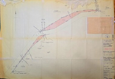
... Title Survey Division/Crown Description/Part of Crown Allotments 106E and 106G2/Parish of Narree Worran, County of Mornington/Cardinia/Shire of Sherbrooke, Wellington Road/Rossley Paul Gardiner of Kirkpatrick & Webber, 289 Maroondah Hwy, Ringwood/Signed S.R. ...Emerald Museum & Nobelius Heritage Park 5 Crichton Rd Emerald yarra-valley-and-the-dandenong-ranges Title Survey Division/Crown Description/Part of Crown Allotments 106E and 106G2/Parish of Narree Worran, County of Mornington/Cardinia/Shire of Sherbrooke, Wellington Road/Rossley Paul Gardiner of Kirkpatrick & Webber, 289 Maroondah Hwy, Ringwood/Signed S.R. ...Image of Surveyors map outlining part of Wellington Rd., Near Magpie Rd., Clematis 1972Title Survey Division/Crown Description/Part of Crown Allotments 106E and 106G2/Parish of Narree Worran, County of Mornington/Cardinia/Shire of Sherbrooke, Wellington Road/Rossley Paul Gardiner of Kirkpatrick & Webber, 289 Maroondah Hwy, Ringwood/Signed S.R. Clarke 21.6.72/B.A. Gibson C/T 8047/414 subtract 0.01 1/2 for Title -
 Narre Warren and District Family History Group
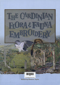
Book, Eleanor Taylor, The Cardinian Flora & Fauna Embroidery, 2017
... Flora and Fauna of the Shire of Cardinia were embroidered in this artwork. ...Narre Warren and District Family History Group 110 High Street Berwick melbourne Flora and Fauna of the Shire of Cardinia were embroidered in this artwork. ...A wide variety of hand embroidery stiches were used, as well as machine embroidery on hand-painted fabric.Tree trunks were mainly appliqued but some some were cross-stiched; distant foliage is free machine embroidery on water-soluble fabric and closer foliage consists of individually embroidered leaves.All 55 embroideries of birds, animals, fish, insects, plants, fence posts, logs, rocks, etc. were worked by 15 people.312 residents, families and friends added their stiches to the canvaswork label panel.24 pagesnon-fictionA wide variety of hand embroidery stiches were used, as well as machine embroidery on hand-painted fabric.Tree trunks were mainly appliqued but some some were cross-stiched; distant foliage is free machine embroidery on water-soluble fabric and closer foliage consists of individually embroidered leaves.All 55 embroideries of birds, animals, fish, insects, plants, fence posts, logs, rocks, etc. were worked by 15 people.312 residents, families and friends added their stiches to the canvaswork label panel. embroidery, cardinia flora, cardinia fauna -
 Uniting Church Archives - Synod of Victoria
Photograph, 1986
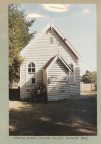
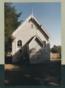
... The church may be the oldest (in part) public building in Cardinia Shire. This is a simple gabled church, clad with weatherboards and roofed with corrugated iron. ...The church may be the oldest (in part) public building in Cardinia Shire. This is a simple gabled church, clad with weatherboards and roofed with corrugated iron. ...Tynong North former Methodist Church, originally known as Christ Church, Berwick, has been an important community meeting place from c1870 and is significant to the Cardinia and Casey Shires as a major and early public building in both districts. The church may be the oldest (in part) public building in Cardinia Shire. This is a simple gabled church, clad with weatherboards and roofed with corrugated iron. It has a gabled porch with finial and distinctive arched openings (windows and doors) which may be indicative of its reputed early date (c1870), as linked with its classical styling. The windows have multi-paned glazing and the roof gable retains its finial. The concrete stumps and lack of mature planting around the church confirm that it has been moved to the site and restumped. Ref: https://vhd.heritagecouncil.vic.gov.au/places/30143/download-reportColour exterior view of the Tynong North Uniting Church, Clarke Rd. Tynong. The image shows a timber church with a porch.tynong north uniting church -
 Uniting Church Archives - Synod of Victoria
Photograph, 1986
... The church may be the oldest (in part) public building in Cardinia Shire. This is a simple gabled church, clad with weatherboards and roofed with corrugated iron. ...The church may be the oldest (in part) public building in Cardinia Shire. This is a simple gabled church, clad with weatherboards and roofed with corrugated iron. ...Tynong North former Methodist Church, originally known as Christ Church, Berwick, has been an important community meeting place from c1870 and is significant to the Cardinia and Casey Shires as a major and early public building in both districts. The church may be the oldest (in part) public building in Cardinia Shire. This is a simple gabled church, clad with weatherboards and roofed with corrugated iron. It has a gabled porch with finial and distinctive arched openings (windows and doors) which may be indicative of its reputed early date (c1870), as linked with its classical styling. The windows have multi-paned glazing and the roof gable retains its finial. The concrete stumps and lack of mature planting around the church confirm that it has been moved to the site and restumped. Ref: https://vhd.heritagecouncil.vic.gov.au/places/30143/download-reportColour exterior view of the Tynong North Uniting Church, Clarke Rd. Tynong. The image shows a timber church with a porch.tynong north uniting church -
 Emerald Museum & Nobelius Heritage Park
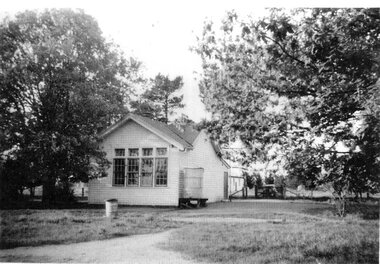
Photograph - Mountain District Community Health Service and Cockatoo Instant Welfare Centre 1960s, c. 1964
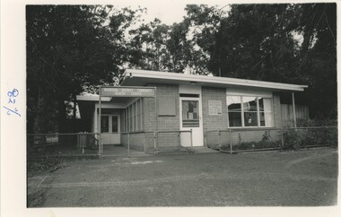
... Alongside the development of the MDCHS, the Berwick Shire council (now part of Cardinia Shire) decided to assign an Infant Welfare Nurse to Cockatoo in order to assist with an influx of new babies in the area. ...Alongside the development of the MDCHS, the Berwick Shire council (now part of Cardinia Shire) decided to assign an Infant Welfare Nurse to Cockatoo in order to assist with an influx of new babies in the area. ...The Mountain District Community Health Service (MDCHS) was conceived of by Cockatoo local Myrtle Quicke, a well-renowned medical professional and nurse in the early-mid 1900s, as well as a founder of the Australian College of Nursing. After moving to Cockatoo in 1954, she quickly realised the shortage of adequate medical care in the area and organised the establishment of the MDCHS. This involved fundraisers and meetings with both locals and council officials to drum up funding and support against opposition who believed there was no need for such a centre. For many years, money was raised for the MDCHS by an opportunity shop nearby until the centre opened on the 3rd of March, 1964. It operated on a membership service, costing £1/5 a year for a single man or woman with no dependents, and a nurse was in attendance 24-hours a day. Alongside the development of the MDCHS, the Berwick Shire council (now part of Cardinia Shire) decided to assign an Infant Welfare Nurse to Cockatoo in order to assist with an influx of new babies in the area. An Infant Welfare Centre was attached to the MDCHS, and opened at the same time. Myrtle joked that she would have the Queen open the building, but it was instead opened by the Governor of Victoria, Sir Rohan Delacombe. The day was one of great celebration for all in the town.This photograph documents the growth of local healthcare and medicine, as well as one of the many accomplishments of Myrtle Quicke.A black and white photograph of the front of a brick building. The building is enclosed by a low metal fence and two open gates, and sits on an unsealed road. Behind the building are a number of tall trees. On the reverse of the photograph is a handwritten pencil caption.In photograph, on freestanding sign: "MOUNTAIN DISTRICT COMMUNITY / HEALTH SERVICE" In photograph, on sign on brick wall: "COCKATOO / INFANT WELFARE / CENTRE" Reverse, handwritten in pencil: "'MOUNTAIN DISTRICT COMMUNITY / HEALTH SERVICE' / AND / 'COCKATOO INFANT WELFARE CENTRE 1960's'"cockatoo, 1960s, medical & health -
 Ballarat Heritage Services
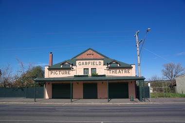
Photograph - Photograph - Colour, Clare Gervasoni, Garfield Picture Theatre, 2011, 27/08/2017
... The Garfield Picture Theatre was Cardinia Shire’s first cinema in the region, followed by Kooweerup’s Wattle Theatre and Pakenham’s King’s Picture Theatre which opened in mid to late 1927. ...The Garfield Picture Theatre was Cardinia Shire’s first cinema in the region, followed by Kooweerup’s Wattle Theatre and Pakenham’s King’s Picture Theatre which opened in mid to late 1927. ...The Garfield Picture Theatre was built in 1924 for Martin Donohue, and according to Mr H. Arnold, who wrote a history of the theatre, it was leased to J. Taylor. It was said to have seated 800 people, and dances were held on Friday evenings with pictures shown on Saturday nights. The theatre was one of the many movie-viewing venues constructed during the Australia-wide boom in cinema building in the 1920s. The Garfield Picture Theatre was Cardinia Shire’s first cinema in the region, followed by Kooweerup’s Wattle Theatre and Pakenham’s King’s Picture Theatre which opened in mid to late 1927. The theatre is significant to the area as it’s one of the few picture theatre buildings remaining in the shire. The Garfield Picture Theatre was not only the main entertainment hub for the area, but it was the town’s first source of electricity. The theatre closed in 1962 and reopened in the 1980s as the Garfield Trading Centre, owned by Sam Jensen, who used to sell used furniture, bric-a-brac and antiques. The theatre stayed that way until 2001, when renovations began by owners Fred and Susan Perez. The theatre was in need of some serious repair and improvement. Fred and Susan spent 17 years relaying and polishing the original floorboards, installing roof insulation, as well as building a commercial kitchen, inside toilets with a disable toilet, upstairs living quarters, full verandah, and drainage and decking around the whole outer edge of the theatre. The theatre is a well-preserved and gabled red brick building, with internal renovations creating a grander experience than the original. The front facade still has its original raised cement letters `Garfield Picture Theatre' and sits above a deep cantilever street verandah which extends the front of the building. The Garfield Picture Theatre made a triumphant return as an entertainment venue on Sunday 03 July 2016, and now hosts various music events and is a great venue for weddings, corporate events and dances. The theatre seats 250 and has a lovely outside area with beautiful gardens including piano. Colour photographs of the Garfield Picture Theatre.garfield, garfield theatre -
 Narre Warren and District Family History Group
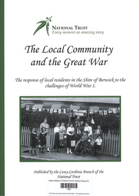
Book, Ian Good, The local community and the Great War : the response of local residents in the Shire of Berwick to the challenges of World War 1, 2016
... The response of local residents in the Shire of Berwick to the challenges of World War 1 The local community and the Great War : the response of local residents in the Shire of Berwick to the challenges of World War 1 Book Ian Good National Trust of Australia (Victoria). Casey-Cardinia ...The response of local residents in the Shire of Berwick to the challenges of World War 1non-fictionThe response of local residents in the Shire of Berwick to the challenges of World War 1world war 1914-1918, berwick (vic.) -
 Narre Warren and District Family History Group
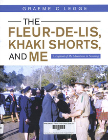
Book, Graeme C Legge, The Fleur-De-Lis, Khaki Shorts and Me: A Logbook of My Adventures in Scouting, 2022
... It commences through the eyes of a youth, Graeme Legge, who joined the re-established Emerald Scout Group as a 12 year old in 1948 and recounts his leadership and support to youth and community of his town, its Scout District and Cardinia Shire over more than seven decades. Graeme shares his early Scouting travel experiences in the 1950s to Fraser Island in Queensland, to the Pieman River in western Tasmania, to Jamborees at Wonga Park, Victoria in 1948, Greystanes, Sydney in 1952 and Clifford Park, Victoria, 1956 as something we the readers can contrast with how Scouting does such adventures today.He outlines four months of overseas travel to the UK in 1951 as part of the “Sun” newspaper Youth Travel scheme where he met some fellow Scouts who, like him, were chosen to represent their local Shire and he visited places and experiences which clearly had an impact on his future Scouting journey. ...'This Log Book is much more than its title suggests. This is the story of Scouting and of community service in and around Emerald, Victoria and ref lects the impact of Scouting in a semi-rural part of Victoria and Graeme’s role in moulding a part of it. It commences through the eyes of a youth, Graeme Legge, who joined the re-established Emerald Scout Group as a 12 year old in 1948 and recounts his leadership and support to youth and community of his town, its Scout District and Cardinia Shire over more than seven decades. Graeme shares his early Scouting travel experiences in the 1950s to Fraser Island in Queensland, to the Pieman River in western Tasmania, to Jamborees at Wonga Park, Victoria in 1948, Greystanes, Sydney in 1952 and Clifford Park, Victoria, 1956 as something we the readers can contrast with how Scouting does such adventures today.He outlines four months of overseas travel to the UK in 1951 as part of the “Sun” newspaper Youth Travel scheme where he met some fellow Scouts who, like him, were chosen to represent their local Shire and he visited places and experiences which clearly had an impact on his future Scouting journey. He captures the mood and the energy of his years of Scouting Leadership, as when he met Lady Baden-Powell in Emerald, illustrated through his photos, clippings and graphics which are drawn from his personal collection and research of local newspapers in the Victorian Scout Magazine, all befitting the method of a teaching and educational professional."--Foreword.159 p.non-fiction'This Log Book is much more than its title suggests. This is the story of Scouting and of community service in and around Emerald, Victoria and ref lects the impact of Scouting in a semi-rural part of Victoria and Graeme’s role in moulding a part of it. It commences through the eyes of a youth, Graeme Legge, who joined the re-established Emerald Scout Group as a 12 year old in 1948 and recounts his leadership and support to youth and community of his town, its Scout District and Cardinia Shire over more than seven decades. Graeme shares his early Scouting travel experiences in the 1950s to Fraser Island in Queensland, to the Pieman River in western Tasmania, to Jamborees at Wonga Park, Victoria in 1948, Greystanes, Sydney in 1952 and Clifford Park, Victoria, 1956 as something we the readers can contrast with how Scouting does such adventures today.He outlines four months of overseas travel to the UK in 1951 as part of the “Sun” newspaper Youth Travel scheme where he met some fellow Scouts who, like him, were chosen to represent their local Shire and he visited places and experiences which clearly had an impact on his future Scouting journey. He captures the mood and the energy of his years of Scouting Leadership, as when he met Lady Baden-Powell in Emerald, illustrated through his photos, clippings and graphics which are drawn from his personal collection and research of local newspapers in the Victorian Scout Magazine, all befitting the method of a teaching and educational professional."--Foreword. scouting, emerald (vic.), graeme legge -
 Cockatoo History & Heritage Group
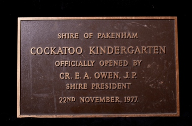
Plaque, Cockatoo Kindergarten - Official Opening Plaque
... Cardinia Council started demolishing the building. The local community were successful in putting a halt to the demolition and saved the building. It will become an integral part of the Cockatoo Ash Wednesday memorial. Details on the fight to save the kinder building can be found at https://sites.google.com/site/cockatoosheritageashwednesday/ Cockatoo Kindergarten Opening Shire of Pakenham Cockatoo Kindergarten Officially Opened by Cr E A Owen J.P Shire President 22nd November 1977 Brass Plaque, depicting the opening of the Cockatoo Kindergarten by the Shire of Pakenham Shire President - Cr Owen Cockatoo Kindergarten - Official Opening Plaque Plaque ...In 1977 residents of Cockatoo built a kindergarten in McBride Street Cockatoo to service the growing population in the area. The building was officially opened on the 22nd of November of that year. Residents formed a Co-op, raised all the money to build the kinder along with lawn bowls and tennis sporting facilities for the town. No small feat, let alone for a town with a population of around 3000. The land was provided by the council for the kinder to use and that was their sole contribution to the building of the kinder. The unique building, was designed by Richard Allen and depicted a children's carousel. The design was to provide a feeling of enjoyment and friendship to the children who used the building. The large glass windows that were installed on the north-eastern side of the building made up 1/3 of the exterior wall. This overlooked the playground of the kinder making it easy to see the children at play from inside. The site of the building is in a dominant position and is highly visible to all who travel through Cockatoo. It was used as a child care facility right up until 2005. The kindergarten has recently been granted heritage listing after Cardinia Council started demolishing the building. The local community were successful in putting a halt to the demolition and saved the building. It will become an integral part of the Cockatoo Ash Wednesday memorial. Details on the fight to save the kinder building can be found at https://sites.google.com/site/cockatoosheritageashwednesday/ Brass Plaque, depicting the opening of the Cockatoo Kindergarten by the Shire of Pakenham Shire President - Cr OwenShire of Pakenham Cockatoo Kindergarten Officially Opened by Cr E A Owen J.P Shire President 22nd November 1977cockatoo, kindergarten opening, -
 Emerald Museum & Nobelius Heritage Park
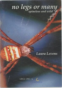
Book, Laura Levens, No Legs or Many: Spineless and Wild, 2007
... Upper Beaconsfield Animals This book was published in 2007 by the Upper Beaconsfield Conservation Group, with support from Cardinia Shire. It contains colour photographs of dozens of arthropods identified "in grassy woodland on a steep hillside near Upper Beaconsfield." ...This book was published in 2007 by the Upper Beaconsfield Conservation Group, with support from Cardinia Shire. It contains colour photographs of dozens of arthropods identified "in grassy woodland on a steep hillside near Upper Beaconsfield." It sorts arthropods from 'no legs' - e.g. flatworms and slugs - to millipedes with 'how many legs'. Each image is accompanied by scientific, observed, and conmtextual information, such as the creature's scientific name and family, and its native or introduced status.This item is a short 45-page paperback book mostly containing colour images of a wide variety of arthropods local to and observed in Upper Beaconsfield, in order of their number of legs. On page 40, a printed and glued insert contains errata. The final numbered page is printed on the inside rear cover. There is a colour photograph of an Argiope keyserlingi spider on the cover, accompanied by miscellaneous detail insets of other creatures. The front inset cover has a black and white photograph of a Tenodera australasiae praying mantis.non-fictionThis book was published in 2007 by the Upper Beaconsfield Conservation Group, with support from Cardinia Shire. It contains colour photographs of dozens of arthropods identified "in grassy woodland on a steep hillside near Upper Beaconsfield." It sorts arthropods from 'no legs' - e.g. flatworms and slugs - to millipedes with 'how many legs'. Each image is accompanied by scientific, observed, and conmtextual information, such as the creature's scientific name and family, and its native or introduced status.upper beaconsfield, animals -
Southern Sherbrooke Historical Society Inc.
Rate Books (CD) Shires of Berwick (1875-1900) and Fern Tree Gully (1892-1934)
... Berwick Shire rate books digitally archived onto CD's by Casey Cardinia Library Corporation. ...Berwick Shire rate books digitally archived onto CD's by Casey Cardinia Library Corporation. ...Rate books initially created between 1875 and 1934. Berwick Shire rate books digitally archived onto CD's by Casey Cardinia Library Corporation. Ferntree Gully Shire rate books digitally archived onto CD's on behalf of the Shire of Yarra Ranges.Red folder containing 4 CD's, including electronic records of rate books from Shire of Berwick Shire/Ferntree Gully. Includes: Berwick Shire Rate Books 1875 to 1900. Shire of Fern Tree Gully Rate Books 1892-1923. Shire of Fern Tree Gully Rate Books 1924-1929. Shire of Fern Tree Gully Rate Books 1930-1934.rate books, local government, ferntree gully shire, berwick shire. -
 Narre Warren and District Family History Group
Document, Hallam State School No. 244 compilation
... Cardinia Library Corporation's Local History Archive relating to Hallam State School No. 244 by Lorraine Taylor. Including: - Notice of installation of septic tank system and erection of standard type residence on school site 1951. - School Committee Annual Report 1963. - Discussion re pupils attending school in Dandenong while Hallam had only 35 pupils enrolled. Suggestion that the area between Hallam and Doveton Avenue be zoned for new children coming into the area, preventing them traveling to Dandenong 1954. - Letter from Shire...Cardinia Library Corporation's Local History Archive relating to Hallam State School No. 244 by Lorraine Taylor. Including: - Notice of installation of septic tank system and erection of standard type residence on school site 1951. - School Committee Annual Report 1963. - Discussion re pupils attending school in Dandenong while Hallam had only 35 pupils enrolled. Suggestion that the area between Hallam and Doveton Avenue be zoned for new children coming into the area, preventing them traveling to Dandenong 1954. - Letter from Shire ...The school was established in 1858 as the Eumemmering Denominational School (Catholic) in a wattle and daub building. Head teacher Daniel Cusack enrolled 44 pupils. In 1862 in the change-over to a new system, the school became Eumemmering Common School No. 244. As from the beginning of 1873 the school became SS244 Eumemmering. The school has had three different sites. In 1894 it became an adjunct of Dandenong SS1403, with only the infant school remaining the original site. Following a deputation of parents, the school was detached from Dandenong and reunited in a new building on Hallam’s Road in 1904. From 1906 to 1923, its official name was Hallam’s Rd, but from 1923 onwards it has been called Hallam. With the growth of the Dandenong area through establishment of new big industries, Hallam School enjoyed bigger enrolments, so that by 1958 the Public Hall, across the highway, was rented for extra accommodation. A tragic accident in October 1962 caused realisation of the danger of this arrangement. A larger school was built on a new site on Harmer Road in 1963. (Vision and Realisation).Compilation of copies of documents found in Casey Cardinia Library Corporation's Local History Archive relating to Hallam State School No. 244 by Lorraine Taylor. Including: - Notice of installation of septic tank system and erection of standard type residence on school site 1951. - School Committee Annual Report 1963. - Discussion re pupils attending school in Dandenong while Hallam had only 35 pupils enrolled. Suggestion that the area between Hallam and Doveton Avenue be zoned for new children coming into the area, preventing them traveling to Dandenong 1954. - Letter from Shire of Berwick asking for a children's crossing on the highway in front of the Hallam Hall 1959. - Hallam State School Annual Report 1963. - Opening of new 105 year old school 1963. - Hallam State School No. 244 Opening Day booklet [contains short history of school, office bearers committee and mothers' club] 1963. - Request for permission to place a bronze plaque remembering Gregory James Martin, a pupil of the school who was fatally injured on the school crossing 22 October 1962. - List of staff September 1988. hallam primary school no 244, hallam (vic.), george chudleigh, leonard stanley reid, george leonard tilley, keith ewart