Showing 5 items matching "cast iron lookout"
-
 Glen Eira Historical Society
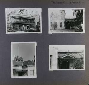
Album - Album page, Heatherbrae, 73 Neerim Road, Circa 1972
... cast iron columns...return verandah...garden...1870's...intricate lacework...neerim road...booran road...1880's...1890's...mansion...john c. holland...bluestone foundations...italianate...iron roofed balcony...cast iron balustrade...balcony...ornamented pediment...mosaic tiles...cast iron lookout...Its social value rests on its ability to demonstrate a past lifestyle. trevor hart verandah chimneys decorative brackets cast iron columns return verandah garden 1870's intricate lacework neerim road booran road 1880's 1890's mansion john c. holland bluestone foundations italianate iron roofed balcony cast iron balustrade balcony ornamented pediment mosaic tiles cast iron lookout flagpole george f griffiths mcgowan tower caulfield heatherbrae cast iron work victorian style john holland porte-cochere porches lead lights george griffiths mansions stables councillors outbuildings Handwritten: "Heatherbrae" 73 Neerim Road [top right] / 142 [bottom right] Page 142 of Photograph Album with four photographs (three landscape, one portrait) of Heatherbrae on Neerim Road. ...This photograph is part of the Caulfield Historical Album 1972. This album was created in approximately 1972 as part of a project by the Caulfield Historical Society to assist in identifying buildings worthy of preservation. The album is related to a Survey the Caulfield Historical Society developed in collaboration with the National Trust of Australia (Victoria) and Caulfield City Council to identify historic buildings within the City of Caulfield that warranted the protection of a National Trust Classification. Principal photographer thought to be Trevor Hart, member of Caulfield Historical Society. Most photographs were taken between 1966-1972 with a small number of photographs being older and from unknown sources. All photographs are black and white except where stated, with 386 photographs over 198 pages.From Victorian Heritage Database citation for Heatherbrae HO46 https://vhd.heritagecouncil.vic.gov.au/places/120933 (as at 28/10/2020) "Heatherbrae" at 73 Neerim Road, Glenhuntly, is a substantial Victorian residential complex made up of two principal construction stages (pre 1876 and c. 1890) and outbuildings including stables. It is aesthetically, historically and socially significant. Its aesthetic value is demonstrated by the manner in which the two periods of construction survive, the earliest being of greater architectural interest on account of its tower and facade treatment, the latter phase adopting a common villa form. The importance of the complex is heightened by its intact state and surviving outbuildings. "Heatherbrae's" historical significance lies in its link with locally known business man and Shire of Caulfield councillor, John Charles Holland. Its social value rests on its ability to demonstrate a past lifestyle.Page 142 of Photograph Album with four photographs (three landscape, one portrait) of Heatherbrae on Neerim Road.Handwritten: "Heatherbrae" 73 Neerim Road [top right] / 142 [bottom right]trevor hart, verandah, chimneys, decorative brackets, cast iron columns, return verandah, garden, 1870's, intricate lacework, neerim road, booran road, 1880's, 1890's, mansion, john c. holland, bluestone foundations, italianate, iron roofed balcony, cast iron balustrade, balcony, ornamented pediment, mosaic tiles, cast iron lookout, flagpole, george f griffiths, mcgowan, tower, caulfield, heatherbrae, cast iron work, victorian style, john holland, porte-cochere porches, lead lights, george griffiths, mansions, stables, councillors, outbuildings -
 Glen Eira Historical Society
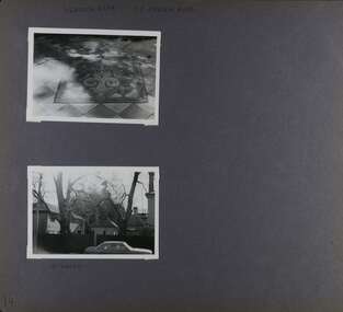
Album - Album page, Heatherbrae, 73 Neerim Road, Circa 1972
... cast iron columns...return verandah...garden...1870's...neerim road...booran road...1880's...1890's...mansion...john c. holland...bluestone foundations...italianate...iron roofed balcony...cast iron balustrade...mosaic tiles...cast iron lookout...Its social value rests on its ability to demonstrate a past lifestyle. trevor hart chimneys cast iron columns return verandah garden 1870's neerim road booran road 1880's 1890's mansion john c. holland bluestone foundations italianate iron roofed balcony cast iron balustrade mosaic tiles cast iron lookout flagpole george f griffiths residential villa caulfield heatherbrae victorian style cast iron work stables outbuildings john holland george griffiths councillors mansions Handwritten: "HEATHERBRAE" 73 NEERIM ROAD [top] / STABLE [under bottom photo] / 143 [bottom left] Page 143 of Photograph Album with 2 landscape photographs of Heatherbrae on Neerim Road - paving insignia and side view. ...This photograph is part of the Caulfield Historical Album 1972. This album was created in approximately 1972 as part of a project by the Caulfield Historical Society to assist in identifying buildings worthy of preservation. The album is related to a Survey the Caulfield Historical Society developed in collaboration with the National Trust of Australia (Victoria) and Caulfield City Council to identify historic buildings within the City of Caulfield that warranted the protection of a National Trust Classification. Principal photographer thought to be Trevor Hart, member of Caulfield Historical Society. Most photographs were taken between 1966-1972 with a small number of photographs being older and from unknown sources. All photographs are black and white except where stated, with 386 photographs over 198 pages.From Victorian Heritage Database citation for Heatherbrae HO46 https://vhd.heritagecouncil.vic.gov.au/places/120933 as at (28/10/2020) "Heatherbrae" at 73 Neerim Road, Glenhuntly, is a substantial Victorian residential complex made up of two principal construction stages (pre 1876 and c. 1890) and outbuildings including stables. It is aesthetically, historically and socially significant. Its aesthetic value is demonstrated by the manner in which the two periods of construction survive, the earliest being of greater architectural interest on account of its tower and facade treatment, the latter phase adopting a common villa form. The importance of the complex is heightened by its intact state and surviving outbuildings. "Heatherbrae's" historical significance lies in its link with locally known business man and Shire of Caulfield councillor, John Charles Holland. Its social value rests on its ability to demonstrate a past lifestyle. Page 143 of Photograph Album with 2 landscape photographs of Heatherbrae on Neerim Road - paving insignia and side view.Handwritten: "HEATHERBRAE" 73 NEERIM ROAD [top] / STABLE [under bottom photo] / 143 [bottom left]trevor hart, chimneys, cast iron columns, return verandah, garden, 1870's, neerim road, booran road, 1880's, 1890's, mansion, john c. holland, bluestone foundations, italianate, iron roofed balcony, cast iron balustrade, mosaic tiles, cast iron lookout, flagpole, george f griffiths, residential villa, caulfield, heatherbrae, victorian style, cast iron work, stables, outbuildings, john holland, george griffiths, councillors, mansions -
 Greensborough Historical Society
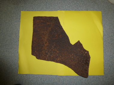
Bath and bed head (remnants), Partington family, remnants of bath and bed head, 1900c
... All except Eva were born at Willis Vale. 9from Faye Fort) Remnants of two of the Partington family homes, both destroyed by fire. partington bosch willis vale lookout point baths bed heads furniture greensborough Cast-iron, rusted. ...This piece of an old bath dates back to the late 1800s to early 1900s. The bath would have been used by the Partington or Bosch families at the property at Point Lookout. This piece is from a bath that was used by our grandfather (born in 1872) when the family lived at Point Lookout before the Partington family bought Willis Vale in 1878. The bath remnant was retrieved after fire destroyed the house. Bed head (remnant): From the Willis Vale homestead. The Partingtons purchased Willis Vale in 1878. William James Partington (1872-1941) and his wife Annie May (1874-1965). They were the parents of Eva, Grace, Alan, Jess and Jack. All except Eva were born at Willis Vale. 9from Faye Fort)Remnants of two of the Partington family homes, both destroyed by fire.Cast-iron, rusted. Section of base of bath and one upright post from bed head.partington, bosch, willis vale, lookout point, baths, bed heads, furniture, greensborough -
 Department of Energy, Environment and Climate Action
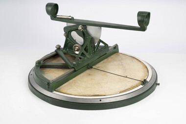
Fire Finder
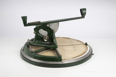
... cast iron circular object with a paper topographic map mounted on it. The metal dial and ruler works similar to a compass. The sight tube is used to determine the bearing and elevation of the fire on the map. This Fire Finder also sometimes known as an Alidade. Its a different design from the Osborne Fire Finder widely used in North American fire lookouts...cast iron circular object with a paper topographic map mounted on it. The metal dial and ruler works similar to a compass. The sight tube is used to determine the bearing and elevation of the fire on the map. This Fire Finder also sometimes known as an Alidade. Its a different design from the Osborne Fire Finder widely used in North American fire lookouts ...Victoria once had well over one hundred fire lookouts and firetowers. Fire lookouts, or observation posts, were often just a clearing on a hill or a vantage point, whereas firetowers were definite structures. Many were established by the Forests Commission Victoria (FCV) in the 1920s, but the network was expanded rapidly in response to recommendations of the Stretton Royal Commission after the 1939 Black Friday bushfires. When a fire or smoke was spotted from the tower a bearing was taken with the alidade and radioed or telephoned into the district office. It was then cross referenced with bearings from other towers on a large wall map to give a "fix" on the fire location. Alidades and telescopes were used in the post war period but were replaced with a much simpler map table and reference string suspended from the centre of the tower cabin. This "Fire Finder" was used in Canadian fire towers to identify the location of wildfires. The unique design was first developed by the British Columbia Forest Service (BCFS) in the early 1950s. Close examination of the map indicates that this particular Fire Finder may have been once used at Bluejoint Mountain lookout in Granby Provincial Park. This Fire Finder was a gift to Barry (Rocky) Marsden from the British Columbia Forest Service in the late 1980s in recognition of the close relationships that had been forged with the staff at the Altona Workshops over many decades. Fire Finders were originally painted black but this one was repainted green after it arrived at Altona. The BC Forest Service had a large facility where they manufactured Fire Finders and many other items of equipment, but in the 1980s it was shut down. Heavy cast iron circular object with a paper topographic map mounted on it. The metal dial and ruler works similar to a compass. The sight tube is used to determine the bearing and elevation of the fire on the map. This Fire Finder also sometimes known as an Alidade. Its a different design from the Osborne Fire Finder widely used in North American fire lookouts from the 1920s. British Columbia Forest Service. Model 62A. Serial Number 6308.bushfire -
 Department of Energy, Environment and Climate Action
Fire Finder
... cast iron circular object with a paper topographic map mounted on it. The metal dial and ruler works similar to a compass. The sight tube is used to determine the bearing and elevation of the fire on the map. This Fire Finder also sometimes known as an Alidade. Its a different design from the Osborne Fire Finder widely used in North American fire lookouts...cast iron circular object with a paper topographic map mounted on it. The metal dial and ruler works similar to a compass. The sight tube is used to determine the bearing and elevation of the fire on the map. This Fire Finder also sometimes known as an Alidade. Its a different design from the Osborne Fire Finder widely used in North American fire lookouts ...Victoria once had well over one hundred fire lookouts and firetowers. Fire lookouts, or observation posts, were often just a clearing on a hill or a vantage point, whereas firetowers were definite structures. Many were established by the Forests Commission Victoria (FCV) in the 1920s, but the network was expanded rapidly in response to recommendations of the Stretton Royal Commission after the 1939 Black Friday bushfires. When a fire or smoke was spotted from the tower a bearing was taken with the alidade and radioed or telephoned into the district office. It was then cross referenced with bearings from other towers on a large wall map to give a "fix" on the fire location. Alidades and telescopes were used in the post war period but were replaced with a much simpler map table and reference string suspended from the centre of the tower cabin. This "Fire Finder" was used in Canadian fire towers to identify the location of wildfires. The unique design was first developed by the British Columbia Forest Service (BCFS) in the early 1950s. Close examination of the map indicates that this particular Fire Finder may have been once used at Bluejoint Mountain lookout in Granby Provincial Park. This Fire Finder was a gift to Barry (Rocky) Marsden from the British Columbia Forest Service in the late 1980s in recognition of the close relationships that had been forged with the staff at the Altona Workshops over many decades. Fire Finders were originally painted black but this one was repainted green after it arrived at Altona. The BC Forest Service had a large facility where they manufactured Fire Finders and many other items of equipment, but in the 1980s it was shut down. Heavy cast iron circular object with a paper topographic map mounted on it. The metal dial and ruler works similar to a compass. The sight tube is used to determine the bearing and elevation of the fire on the map. This Fire Finder also sometimes known as an Alidade. Its a different design from the Osborne Fire Finder widely used in North American fire lookouts from the 1920s. British Columbia Forest Service. Model 62A. Serial Number 6308.bushfire