Showing 5 items matching "castlemaine residence areas"
-
 Bendigo Historical Society Inc.
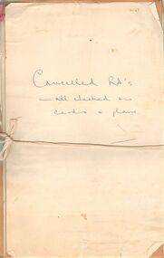
Document - LANDS OFFICE: CANCELLED R.A.'S FROM CASTLEMAINE/BENDIGO/INGLEWOOD
... ...castlemaine residence areas...History House 11 Mackenzie Street Bendigo goldfields PLACE Bendigo castlemaine residence areas Bendigo Sandhurst land sales residence areas miners rights Lands Office Document: collection of individually tied files, tied with faded red ribbon, tied across centre with white tape. ...Document: collection of individually tied files, tied with faded red ribbon, tied across centre with white tape. Applications for right to occupy residence areas - miners rights. On front page ' cancelled R.A's - all checked on cards and plans' written in blue ink.Lands Officeplace, bendigo, castlemaine residence areas, bendigo, sandhurst, land sales, residence areas, miners rights -
 Eltham District Historical Society Inc
Photograph, Woodburn residence, mudbrick adobe (1949), Eltham Heritage Tour, 24 May 1992, 24/05/1992
... area, growing up the hill from the station. It was a typical outer Melbourne suburb with lawns and roses with patches of originality. The shopping precinct still has 1950 characteristics - walls which sloped back, projecting roofs, the original shop fronts are nearly all tiled below the old windows. There's an air of past times about the School, the Dairy, the Butcher's (now a milk bar) and the Castlemaine stone face of the Commonwealth Bank. The final stop for the tour was at the mud-brick Woodburn residence...area, growing up the hill from the station. It was a typical outer Melbourne suburb with lawns and roses with patches of originality. The shopping precinct still has 1950 characteristics - walls which sloped back, projecting roofs, the original shop fronts are nearly all tiled below the old windows. There's an air of past times about the School, the Dairy, the Butcher's (now a milk bar) and the Castlemaine stone face of the Commonwealth Bank. The final stop for the tour was at the mud-brick Woodburn residence ...ELTHAM HERITAGE TOUR The Society excursion on 24th May 1992 was arranged by David Bick, leader of the team carrying out the Shire's heritage study. David selected a number of sites or buildings identified in the study, some of them lesser known components of the Shire's heritage. The tour commenced at the Eltham Shire Office at 10.00 am. Travel was by private car and mini-bus with stops at about twelve locations for commentary by David.It included a short walk in Hurstbridge and lunch at Kinglake. Highlights of the tour included: - 10 am Leave from Shire Offices - 3 Important Trees - A Physical Link to Eltham's First Settlers - Toorak Mansion Gates - A Surviving Farm House - An Intact Circa 1900 Main Street - First Settlers - Gold Miners, and Timber-getters - An Early Hotel - A Pioneering Homestead - Changing Eltham Shire - 20th Century - 4 pm Afternoon Tea and Finish Tour Extract from ELTHAM CULTURAL HERITAGE TOUR (Newsletter No. 85, July 1992, by Bettina Woodburn) "In some respects Eltham is a 'back-water' and it has its own distinctive flavour. On the outskirts the homes date from the 1960's, 70's and 80s with a sprinkling of 'earth homes', mud-brick or pise, rammed dirt. Crossing Main Road into Beddoe Street and Thompson Crescent a very pleasant drive past pines and old fence lines, front lawns unfenced, the occasional ·old farm building, we eventually looked down on a huge circular roof of a 1992 adobe home. Other distinctive places included the Pauline Toner Butterfly Reserve, Gordon Ford's splendid garden at Fulling in Pitt Street, cypress hedges and old houses in Bridge Street and in every direction Eltham's special feature - a totally treed horizon. We were now in the part of the Shire closest to Melbourne - Montmorency - not on the way to anywhere, with no through road going across it, developed in the 1950's and 1960's with conventional gardens, now converted to native plants. The rail looped between Greensborough and Eltham and a shopping street (Were Street) served the area, growing up the hill from the station. It was a typical outer Melbourne suburb with lawns and roses with patches of originality. The shopping precinct still has 1950 characteristics - walls which sloped back, projecting roofs, the original shop fronts are nearly all tiled below the old windows. There's an air of past times about the School, the Dairy, the Butcher's (now a milk bar) and the Castlemaine stone face of the Commonwealth Bank. The final stop for the tour was at the mud-brick Woodburn residence, adobe of 1949 with additions. After War Service, Bill Woodburn had commenced an Architecture course at Melbourne University and after second year in the Christmas vacation, with his wife, Betti, built the two bedroom house - with amazing saving of costs. In the three and a half months they made over 3000 bricks (external walls 18" x 12" x 4", internal walls 12" x 9" x 4"), sifted top soil for mortar and laid them, on concrete foundations and slab floor, made all the structural window frames, door frames and roof members to carry 'super six' asbestos sheets, laboured for the electrician and plumber, did all the glazing and, still without electricity, moved in in March 1949. Rooms have been added, at first with glass walls, later using concrete blocks, to accommodate three daughters and a son. The house not only grew from the earth, but also with the family."Record of the Society's history and activities and highlighting various aspects of the Heritage Study undertaken by David Bick used to create the future heritage overlay for the Shire of Eltham and later Nillumbik Shire.Roll of 35mm colour negative film, 4 stripsKodak Gold 100 5095shire of eltham historical society, activities, heritage tour, woodburn house -
 Bendigo Historical Society Inc.
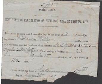
Document - KELLY AND ALLSOP COLLECTION: CERTIFICATE OF REGISTRATION OF RESIDENCE OR BUSINESS, 27/08/1907
... Residence Area or Business Site. Issued to Michael Kelly as the owner of residence area (Part of Allot.2, Section 52) Urquhart St., Castlemaine. ...Residence Registration Certificate Michael Kelly Urquhart St. Castlemaine Unknown Document. KELLY & ALLSOP COLLECTION. Certificate of Registration of Residence Area or Business Site. ...Document. KELLY & ALLSOP COLLECTION. Certificate of Registration of Residence Area or Business Site. Issued to Michael Kelly as the owner of residence area (Part of Allot.2, Section 52) Urquhart St., Castlemaine. Frontage of 40 feet and depth of 132 feet. Dated 27 August 1907. Section at bottom is torn away where signature of issuer would be.Unknownbusiness, stockbroker, kelly & allsop, kelly & allsop collection, residence registration certificate, michael kelly, urquhart st., castlemaine -
 Bendigo Historical Society Inc.
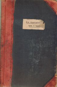
Document - LANDS OFFICE: R. A. APPLICATIONS NOS. 1 - 1930, 1936
... Applications Nos. 1 - 1930' Residence areas - applicants for land Bendigo, Maldon, Castlemaine, Daylesford, Eaglehawk, Marong and district. 1936...Applications Nos. 1 - 1930' Residence areas - applicants for land Bendigo, Maldon, Castlemaine, Daylesford, Eaglehawk, Marong and district. 1936 Document LANDS OFFICE: R. ...Document: green hard cover journal with red spine and corners. On front cover ' R.A. Applications Nos. 1 - 1930' Residence areas - applicants for land Bendigo, Maldon, Castlemaine, Daylesford, Eaglehawk, Marong and district. 1936Lands Officeplace, bendigo, land sales, bendigo, sandhurst, land sales, r.a. applications -
 Ballarat Heritage Services
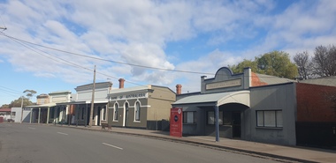
Photograph, Main Street of Talbot, Victoria, 2025, 07/2025
... area around current day Talbot occurred in December 1852 when gold was found in Daisy Hill, near what is now Amherst Cemetery (2km west of Talbot). News quickly spread and within a few weeks hundreds of miners from the nearby Castlemaine goldfields had arrived to try their luck. The next major gold find was in 1854 at Kangaroo Flat along Back Creek (1km out of Talbot). By November 1855 it was reported around 6,000 miners had taken up residence...area around current day Talbot occurred in December 1852 when gold was found in Daisy Hill, near what is now Amherst Cemetery (2km west of Talbot). News quickly spread and within a few weeks hundreds of miners from the nearby Castlemaine goldfields had arrived to try their luck. The next major gold find was in 1854 at Kangaroo Flat along Back Creek (1km out of Talbot). By November 1855 it was reported around 6,000 miners had taken up residence ...Throughout the 1840s there had been rumours of gold found in the area, but the evidence was suppressed. The authorities sought to keep the region as a quiet pastoral district, and feared that a gold rush could spark chaos and lawlessness among the largely convict population. In January 1849, former convict Thomas Chapman found a 38 ounce gold nugget in Daisy Hill Creek (7 km from Talbot) while working as a shepherd. He sold it to Melbourne jeweller Charles Brentani in early 1849. This was the first confirmed finding of gold in Victoria and kicked off a minor rush to the region. By late February 1849 thirty to forty trespassers were reported to have gathered at Thomas's former hut seeking gold before being disbanded by a party of police sent from Melbourne. Meanwhile, Thomas fled to Sydney, fearing trouble after his unauthorised sale of the gold that, according to the law of the time, was illegal. The first major rush in the area around current day Talbot occurred in December 1852 when gold was found in Daisy Hill, near what is now Amherst Cemetery (2km west of Talbot). News quickly spread and within a few weeks hundreds of miners from the nearby Castlemaine goldfields had arrived to try their luck. The next major gold find was in 1854 at Kangaroo Flat along Back Creek (1km out of Talbot). By November 1855 it was reported around 6,000 miners had taken up residence in what became known as Back Creek. But, as the gold dwindled, so too did the population and by end-1857 only a few houses remained. In 1859, a group of miners from Norway and Sweden led by Carl Hallen decided to look in an area just outside of Back Creek, previously thought barren of gold as it was un-forested. Their gamble was rewarded, and as the news spread, miners once again flooded into the area. Within 4 months of the Hallan Party's first shaft being dug, there were 50,000 people in the Back Creek region. To cater for this influx, streets were improvised in the area of the diggings - starting with what became known as "Scandinavian Crescent" along the edge of the actual diggings themselves. It remains to this day and is now the main street of Talbot. (https://www.melbourneplaygrounds.com.au/talbot-heritage-walk accessed 19 July 2025)Colour photograph of shops on Scandinavian Cresent, the Main road of Talbot, Victoriatalbot, back creek, gold mining