
Showing 6 items matching "central avenue burwood"
-
 Whitehorse Historical Society Inc.
Map, Burwood Road, Box Hill City, 1952
... ...central avenue burwood...Country Roads Board survey of Burwood Road, Burwood between Central Avenue and Elgar Road. Includes details of fencing, nature of buildings. ...maps burwood road burwood parer street elgar road cromwell street ireland street central avenue burwood scott grove somers street gilmour street evans street edwards street mills road Country Roads Board survey of Burwood Road, Burwood between Central Avenue and Elgar Road. ...Country Roads Board survey of Burwood Road, Burwood between Central Avenue and Elgar Road. Includes details of fencing, nature of buildings. With penciled additions to 1957.Country Roads Board survey of Burwood Road, Burwood between Central Avenue and Elgar Road. Includes details of fencing, nature of buildings. With penciled additions to 1957.Country Roads Board survey of Burwood Road, Burwood between Central Avenue and Elgar Road. Includes details of fencing, nature of buildings. With penciled additions to 1957.maps, burwood road, burwood, parer street, elgar road, cromwell street, ireland street, central avenue burwood, scott grove, somers street, gilmour street, evans street, edwards street, mills road -
 Ringwood and District Historical Society
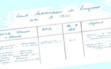
Document - Research Notes, Richard Carter, Land Subdivisions in Ringwood 1890-1950
... Avenue, Burwood Avenue, Bonview Avenue, Heatherbrae Avenue, Margaret Street, Mary Street, Grant Crescent Pg24 RINGWOOD EAST ELECTRIC STATION ESTATE (LP?) (1924) Railway Parade (now Patterrson Street), Federal Road, Howship Avenue (part now French Street), Dublin Road, Rosedale Crescent Pg25 BEDFORD PARK (now Ringwood Secondary College) (LP?) (1924) Bedford Road, Adams Street, Anderson Street, Joyce Street, Graham Road Pg26 CROWN JEWEL ESTATE LP11645 (Private sales after 1924) Mount Dandenong Road, Mirabel Avenue, Valda Avenue, Evon Avenue, Velma Grove Pg27 GRAND CENTRAL...Avenue, Burwood Avenue, Bonview Avenue, Heatherbrae Avenue, Margaret Street, Mary Street, Grant Crescent Pg24 RINGWOOD EAST ELECTRIC STATION ESTATE (LP?) (1924) Railway Parade (now Patterrson Street), Federal Road, Howship Avenue (part now French Street), Dublin Road, Rosedale Crescent Pg25 BEDFORD PARK (now Ringwood Secondary College) (LP?) (1924) Bedford Road, Adams Street, Anderson Street, Joyce Street, Graham Road Pg26 CROWN JEWEL ESTATE LP11645 (Private sales after 1924) Mount Dandenong Road, Mirabel Avenue, Valda Avenue, Evon Avenue, Velma Grove Pg27 GRAND CENTRAL ...Handwritten table listing main local pre-1950s subdivisions in the Ringwood area, with estate names, streets, number of allotments for sale, and where known, vendor agent, LP (Lodged Plan) title registration number, and auction/sale date, some with sale price.Pg1 RINGWOOD STATION ESTATE LP3070 (Year?) Station Street, William Street (now Kendall Street), Wantirna Road, Station Street Pg1 RINGWOOD TOWNSHIP ESTATE LP5577 (1913) Station Road (now Warrandyte Road), Pratt Street (part now Aird Street), Whitehorse Road Pg2 RINGWOOD ORCHARD ESTATE LP4315 (1914) Brysons Road, Hillcrest Road, Anzac Avenue, Sulva Road Pg3 RINGWOOD RAILWAY ESTATE LP7522 (1918) Whitehorse Road (now Mount Dandenong Road), Dublin Road, Freeman Street, Patterson Street, Bona Street Pg4 THE RINGWOOD ESTATE LP7578 (1919) Warrandyte Road, Hobart Street, Paxton Street, Arnold Street Pg5 GARDEN FARMS ESTATE (LP?) (1919) Canterbury Road, Armstrong Road, Bungalook Road, Orchard Road, Bayswater Road (now Mountain Highway) Pg6 THE RINGWOOD ESTATE (SECOND SUB-DIVISION) LP7604 (1919) Warrandyte Road, Tamar Street, Derwent Street, Mersey Street Pg7 RINGWOOD STATION ESTATE LP7703 (1919) Bedford Road, Williams Grove (now Lena Grove) Pg8 RINGWOOD TOWNSHIP ESTATE LP8198 (1919) Wantirna Road, Ellison Street, Haig Street, Greenwood Avenue Pg9 EASTFIELD ESTATE (LP?) (1920) Eastfield Road, Longview Road, Pleasant Rise, The Mount Pg10 ELECTRIC RAILWAY ESTATE RINGWOOD LP9473 (1922) Campbell Street, Myrtle Avenue, George Street (now Tudor Court), Henry Street (now Myrtle Avenue), Williams Grove (now Lena Grove) Pg11 RINGWOOD PARK ESTATE LP7884 (1922 - two stages) Wonga Road (now Loughnan Road), William Street, Andrew Street, Harrison Street Pg12 HEATHMONT STATION ESTATE LP11009 (Date? - after 1922) Lisgoold Street, Viviani Crescent, Balrour Avenue, Station Street (now part Heathmont Road and part Wainui Street) Pg13 RINGWOOD RAILWAY ESTATE LP10507 (1923) Whitehorse Road, Sherbrooke Avenue, Burwood Avenue, Bonview Avenue, Heatherbrae Avenue, Grant Crescent Pg14 GARDEN HOMES ESTATE (LP?) (1923) Mullum Road, The Centreway, Wattle Crescent (now Wattle Avenue) Reserve Crescent (now Reserve Road) Pg15 DUBLIN ROAD ESTATE LP11993 (1923) Alexandra Road, Vonadawn Avenue, Green Street, Wood Street, Howard Avenue, Bedford Road, Dublin Road Pg16 CARLINGA ESTATE RINGWOOD LP9620 (1923) Bourke Street, Bond Street, Ringwood Street Pg17 PRATT'S JUNCTION ESTATE (LP?) (1923) Junction Street, Georges Road, Oliver Street, Whitehorse Road Pg18 EAST RINGWOOD ESTATE LP10492 (1923) Bona Street, Patterson Street, Miller Grove, Fairview Avenue, Eastfield Road, Whitehorse Road (now Mount Dandenong Road) Pg19 COLEMAN'S HEATHMONT ESTATE LP9974 (1923) Canterbury Road, Bedford Road, Alvena Crescent, Coleman Street, Leonard Street (now Royal Avenue) Pg20 RINGWOOD HEIGHTS ESTATE LP10506 (1924) Whitehorse Road, Bonview Avenue, Grant Crescent, Hillcrest Avenue, Heatherbrae Avenue, Margaret Street, Mary Street Pg21 EAST RINGWOOD STATION ESTATE LP10551 (1924) Knaith Road, Wenwood Street, Lois Street, Victoria Street, Station Street (now Railway Avenue) Pg22 GRAND VIEW ESTATE LP11019 (1924) Whitehorse Road, Rupert Street, Herbert Street, Leonard Street Pg23 RINGWOOD RAILWAY ESTATE & RINGWOOD HEIGHTS ESTATE - FINAL SECTIONS LP10506 & LP10507 (1924) Whitehorse Road, Sherbrooke Avenue, Burwood Avenue, Bonview Avenue, Heatherbrae Avenue, Margaret Street, Mary Street, Grant Crescent Pg24 RINGWOOD EAST ELECTRIC STATION ESTATE (LP?) (1924) Railway Parade (now Patterrson Street), Federal Road, Howship Avenue (part now French Street), Dublin Road, Rosedale Crescent Pg25 BEDFORD PARK (now Ringwood Secondary College) (LP?) (1924) Bedford Road, Adams Street, Anderson Street, Joyce Street, Graham Road Pg26 CROWN JEWEL ESTATE LP11645 (Private sales after 1924) Mount Dandenong Road, Mirabel Avenue, Valda Avenue, Evon Avenue, Velma Grove Pg27 GRAND CENTRAL ESTATE LP10917 (1925) Heathmont Road, Great Ryrie Street, Douglas Street, Garden Street, Bellevue Avenue Pg28 RINGWOOD (unnamed estate - 1926) Nelson Street, Seymour Street, Whitehorse Road Pg29 EAST RINGWOOD RAILWAY STATION ESTATE (YEAR? - 25 shops 60 villas) Railway Avenue, Dublin Road, Lawrence Grove, Stanley Avenue, Knaith Road Pg30 CHARM VIEW ESTATE (LP?) (year? - after 1926) Canterbury Road, Heathmont Road, Dickasons Road, Bennjett Avenue, Orchid Street Pg31 SUNBEAM ESTATE LP12150 (Circa 1925) Govt Road (now Old Lilydale Road), Sunbeam Avenue, Holland Road, Everard Street (now Everard Road) Pg32 FAIRVIEW ESTATE EAST RINGWOOD LP10853 (Circa 1924) Eastfield Road, Patterson Street, Margaret Street (now Short Street) Pg33 EAST RINGWOOD TOWNSHIP ESTATE LP3025 (Circa 1924 - 35 allotments) Mount Dandenong Road, Grey Street, Eastfield Road Pg34 EAST RINGWOOD TOWNSHIP ESTATE LP3025 (Circa 1924 - 49 allotments) and STATE SCHOOL ESTATE (26 allotments) and EAST RINGWOOD STATION ESTATE (14 shop sites) Mount Dandenong Road, Grety Street, Dunn Street, Eastfield Road, King Street, Holland Road, Dublin Road, Patterson Street, Bona Street Pg35 EAST RINGWOOD CENTRAL ESTATE LP17004 (1948) Knaith Road, Shasta Avenue, Talofa Avenue, Russet Road, Dublin Road Pg36 WARE ESTATE LP43360 (1958) Ware Crescent, Davey Drive, Grey Road (now Grey Street), Mount Dandenong Road Pg37 Lot 57 Kendall Street LP3070 (1939) £75.0.0 Pg37 Lot 14 LP7346 (year?) £225 Pg37 Lot 8 WHITE HORSE ESTATE LP14010 (year?) Maroondah Hwy, Seymour Street £98.9.0 Pg37 Lots 4-14 incl. LP10902 (year?) £300 Pg37 Lots 69&70 LP2216 (1939) Bedford Road, Pitt Street £500 Pg37 Lots 60&70 LP2216 (year?) £460 Pg37 MOUNTAIN VIEW ESTATE LP10902 (1936) Lots 1&2, 19-22 Wantirna Road, Daisy Street £50 Pg38 RAILWAY STATION ESTATE RINGWOOD EAST LP7522 (1925) Lots 16 to 19 £250 Pg38 RINGWOOD PARK ESTATE (LP?) (1924) Lot 112 Munro Street £230 Pg38 RINGWOOD TOWNSHIP ESTATE (LP?) (1925) Lot 57 Wantirna Road £850 Pg38 ELECTRIC RAILWAY ESTATE LP9473 (1925) Lot 98 & 99 £180 (30/- foot) Pg38 ELECTRIC RAILWAY ESTATE LP9473 (year?) Lot 100 £233.12.6 incl improvements (£2.12.6 foot) Pg38 Lot 22&23 Bedford Road Heathmont (LP & year?) £675 incl improvements Pg39 Lot 9 Mullum Mullum Road LP8221 (1923) £150 Pg39 Lot 27 Haig Street LP8198 (1925) £825 Pg39 Lot 56 Haig Street cnr Wantirna Road LP8198 (1923) £171 Pg39 Lots 3 & 4 Loughnan Road LP9626 (192?) £147 Pg39 Lots 98 & 99 Myrtle Avenue LP9473 (1925) £180 Pg39 Lots 80 & 81 Myrtle Avenue LP9473 (1929) £150 Pg39 Lot 30 Sherbrooke Avenue LP10507 (1926) £700 incl improvements Pg40 Lot 10 (year?) LP7703 £750 Pg40 Lot 36 (year?) LP7522 £25 Pg40 Lot 38 Pitt Street LP2216 (year?) £350 Pg40 Lot 7 Dublin Road cnr Green Street LP11993 (year?) £300 -
 Ringwood and District Historical Society
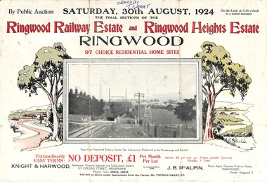
Flyer, Auction Sale Advertisement - Ringwood Railway Estate and Ringwood Heights Estate, Ringwood, Victoria - August, 1924
... Subdivision includes Whitehorse Road, Sherbrooke Avenue, Burwood Avenue, Bon View Avenue, Grant Crescent, Hillcrest Avenue, Heatherbrae Avenue, Margaret Street, and Mary Street. (Agents) Knight & Harwood, 315 Collins Street, Melbourne, Phones Central 10615, 10616, in conjunction with J.B. ...No. 5184 for Ringwood Heights Estate previous release (March 1924) Subdivision includes Whitehorse Road, Sherbrooke Avenue, Burwood Avenue, Bon View Avenue, Grant Crescent, Hillcrest Avenue, Heatherbrae Avenue, Margaret Street, and Mary Street. (Agents) Knight & Harwood, 315 Collins Street, Melbourne, Phones Central 10615, 10616, in conjunction with J.B. ...Refer also to Reg. No. 5183 for Ringwood Railway Estate (September 1923) and Reg. No. 5184 for Ringwood Heights Estate previous release (March 1924)Folded double-sided brochure advertising public auction of Final Sections of Ringwood Railway Estate and Ringwood Heights Estate on Saturday, 30 August, 1924, with town photographs, location map, terms of sale, and summary of local features and services.Subdivision includes Whitehorse Road, Sherbrooke Avenue, Burwood Avenue, Bon View Avenue, Grant Crescent, Hillcrest Avenue, Heatherbrae Avenue, Margaret Street, and Mary Street. (Agents) Knight & Harwood, 315 Collins Street, Melbourne, Phones Central 10615, 10616, in conjunction with J.B. McAlpin, Opposite Railway Station, Ringwood, Phone Ringwood 7. Footnote - "Will sell as above under instructions from the Owner, Mr. Thomas Grant, J.P.". -
 Ringwood and District Historical Society
Flyer, Subdivision Advertisement - Ringwood Railway Estate Public Auction - 1923
... Subdivision includes Whitehorse Road, Bon View Avenue, Grant Crescent, Heatherbrae Avenue, Burwood Avenue, and Sherbrooke Avenue. (Agents) Knight & Harwood, 315 Collins Street, Melbourne, Phones Central 10615, 10616, in conjunction with J.B. ...No. 5185 for Ringwood Railway Estate final section release (August 1924) Subdivision includes Whitehorse Road, Bon View Avenue, Grant Crescent, Heatherbrae Avenue, Burwood Avenue, and Sherbrooke Avenue. (Agents) Knight & Harwood, 315 Collins Street, Melbourne, Phones Central 10615, 10616, in conjunction with J.B. ...Refer also to Reg. No. 5185 for Ringwood Railway Estate final section release (August 1924)Folded double-sided brochure advertising 85 residential allotments and brick cemented villa - Ringwood Railway Estate Public Auction on Saturday 8th September, 1923, with town photographs, location map, terms of sale, and summary of local features and services.Subdivision includes Whitehorse Road, Bon View Avenue, Grant Crescent, Heatherbrae Avenue, Burwood Avenue, and Sherbrooke Avenue. (Agents) Knight & Harwood, 315 Collins Street, Melbourne, Phones Central 10615, 10616, in conjunction with J.B. McAlpin, Opposite Railway Station, Ringwood, Phone Ringwood 7. -
Whitehorse Historical Society Inc.
Map, Burwood Road, Box Hill City, 15/02/1952 12:00:00 AM
... Avenue...Burwood...Central...Avenue and Station Street. Marked as Survey Plan No 5441. Land Subdivision Burwood Road Burwood Milford Avenue Burwood Central Court Burwood Plan of subdivision of ten blocks in Burwood Road, Burwood. ...Plan of subdivision of ten blocks in Burwood Road, Burwood.Plan of subdivision of ten blocks in Burwood Road, Burwood between Milford Avenue and Station Street. Marked as Survey Plan No 5441.Plan of subdivision of ten blocks in Burwood Road, Burwood. land subdivision, burwood road, burwood, milford avenue, burwood, central court, burwood -
 Sunshine and District Historical Society Incorporated
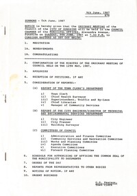
Administrative record - City of Sunshine Council Meetings 1986 - 1994 - Notice of Ordinary Meeting 9th June 1987, City of Sunshine, 5th June 1987
... Central Avenue...First Avenue...McIntyre Road...Bardsley Street...Main Road West...Reid Street...Langley Street...Surrey Street...Highpoint City Shopping Centre...Rosamond Road...Lahy Street...Rothray Avenue...St. Albans Road...Trinacria Court...ICI...Westend Marke...Burwood...Albans Sunshine Road Tottenham Western Highway Ardeer Holt Street Gas & Fuel Depot Somers Street Sunshine Avenue Main Road East Gum Street Davies Avenue Central Avenue First Avenue McIntyre Road Bardsley Street Main Road West Reid Street Langley Street Surrey Street Highpoint City Shopping Centre Rosamond Road Lahy Street Rothray Avenue St. Albans Road Trinacria Court ICI Westend Marke Burwood ...Notice of Ordinary Meeting 9th June 1987 Report of the Town Clerk's Department Report of the Town Clerk Accounts for Payment as at 15th May 1987 Sub Lease by Sunshine and District Helping Hands Darnley Street Sunshine to Minister for Education Proposed Compulsory Acquisition Part 66 Glengala Road for Proposed Roundabout Lease of Lots 1, 2 & 3 Forrest Street from State Transport Authority Cleaning Contract Unexpended Loan Funds Road Closure Part of the Road Reserve Van Ness Avenue Maribyrnong Proposed Discontinuance of the Right of Way Between Ballarat Road and Lawson Street Albion Proposed Closure of Roads Part of Navigator Street, Part of Right of Way Between Clyde Street, Navigator Street, The Esplanade and Chilfley Drive, The Right of Way Between Ensign Street and Chifley Drive Maribyrnong Ardeer South Primary School Finance Maintenance to House Located at the School Agreement Sunshine High School Use of School Playing Fields for Community Use Promotion of Council Events West Community Farm Project Returned Services League ANZAC Day Sunshine RSL St. Albans Community Health & Resource Centre Discontinued Right of Way Between Plantation Street, Newstead Street, The Esplanade & Chifley Drive Maribyrnong Sunshine Park Tennis Club Attempt to Break World Records for Non-Stop Tennis Request for Donation Arthritis Foundation of Victoria North Sunshine Cricket Club Requesting Use of Lloyd Reserve Sunshine / Keilor Liaison Committee May Economic Statement Local Government Bill Bon Thomas Reserve Development Report of the Chief Health Surveyor Registration of Premises Health Act & Food Act Transfer of Registration of Premises Prosecution Proceedings Sunshine Magistrates Court Albanvale Water Supply Report of the Superintendent Traffic & By-laws Dog Act Traffic and Parking Infringements Court Proceedings Parking Problems Tottenham Stores & Disposal Depot Beachley Street Braybrook Urgent Business Council Meeting 10th March 1987 Report of the Chief Librarian Workshop on Costing and Programme Budgeting for Public libraries Information for Local Government Decision Making Conference 3rd - 5th May 1987 Canberra Report Sale of Discarded Books Russian Cataloguing Public Library Funding Report of the Acting Manager Community Services St. Albans Multicultural Consultative Council Municipal Association of Victoria Housing Poster Additional Funds Under Supplementary Service Grant Protective Behaviors Training Rhodes Street Child Care Centre St. Albans Children's Services Consultation Local Government and Community Development Conference 7th - 8th May 1987 Report Victorian Municipal Community Services Association 15th May 1987 Report Child Care Centre Peer Team Review Report Home and Community Care Program Ethnic Food Services Project Marie Mill Community Centre Advisory Committee Castley Hall Redevelopment Project Mini Budget 1987 Raising Funds for the Sunshine Community Nursing Home Report of the City Engineer Road Humps in the Right of Way Between Glendenning Street and McKechnie Street St. Albans Plans for the Construction of Road and Drains for Stage 1 of the Subdivision of Industrial land at Sunshine Road Tottenham Western Highway (Ballarat Road) Right Turn Lane at Esmond Street Ardeer Western Highway (Ballarat Road) / Holt Street Ardeer Gas & Fuel Depot Site Exit Traffic Signal Installation Tenders Somers Street Sunshine North Private Street Scheme Tenders for the Purchase of New Plant Traffic Control Items Motion Garbage Disposal Metal Skips Intersection Sunshine Avenue / Main Road East St. Albans Report of the City Planner Planning Permit Application Flats 17 Gum Street Sunshine West Planning Permit Application Factory Lot 117 Davies Avenue Sunshine North Planning Permit Application Warehouse Lot 16 Central Avenue South East Corner First Avenue Sunshine Planning Permit Application Factory 146 McIntyre Road Sunshine North Planning Permit Application Four Flats 29 Bardsley Street Sunshine West Planning Permit Application Health Centre 115 Main Road West St. Albans Planning Permit Application Factory Lot 1 Reid Street Albion Planning Permit Application Dual occupancy 2 Langley Street Ardeer Planning Permit Application Car Sales Surrey Street Sunshine North Planning Permit Application Extended Trading Hours Highpoint City Shopping Centre Rosamond Road Maribyrnong Planning Permit Application Dual Occupancy 25 Lahy Street St. Albans Planning Permit Application Factory and Caretaker's Residence Lot 56 Rothray Avenue Sunshine North Planning Permit Cafe 5 St. Albans Road St. Albans Planning Permit Application Twenty-Two flats Lot 7 - 16 Trinacria Court Deer Park Planning Permit Application Peripheral Sales 194 McIntyre Road Sunshine North Planning Permit Application Extensions to Adhesives / Polyols Manufacturing Building (Buildings and Works over 7.0 Metres) ICI Ballarat Road Deer Park Planning Permit Application Waregouse 7 Western Avenue Sunshine Melbourne Metropolitan Planning Scheme Amendment No 430 Planning Permit Application Advertising Sign Westend Market 47 McIntyre Road Sunshine North Planning Permit Application Hotel Westend Market 47 McIntyre Road Sunshine North Delegated Matters Plan of Subdivision Lots 4 & 5 Burwood Avenue Sunshine North Plan of Transfer and Plan of Consolidation Fairbairn Road North West Corner Boundary Road Brooklyn Plan of Subdivision J.H. Ralph & Sons Pty Ltd Geelong Road Brooklyn Plan of Strata Subdivision Lot 6 Grant Street South East Corner Gladstone Street St. Albans Plan of Consolidation Lots 229 & 230 Cromer Avenue South East Corner Rothray Avenue Sunshine North Report of the Building Surveyor Dangerous Building 304 Hampshire Road Sunshine Location of Building 8 Arnold Street Sunshine West Location of Building 8 Denton Avenue St. Albans Location of Building 42 Denton Avenue St. Albans Delegation od Victoria Building Regulations Extension of Tome Lot 3 West City Caravan Park Ballarat Road Ardeer Dangerous Building Extension of Time 27 Sun Crescent Sunshine Dangerous Building 32 Gladstone Street St. Albans Dangerous Building 31 First Avenue Sunshine Dangerous Building Unit 1 10 Percy Street St. Albans Dangerous Building 1 White Street Maribyrnong Dangerous Building Unit 3 10 Percy Street St. Albans Schedule for Authorising of Affixing the Common Seal of the Municipality to Documents Orders of the Day Various Loans Proposed Closure of the Right of Way Between Ballarat Road and Lawson Street from the Eastern Boundary of Lot 12 Ballarat Road to Adelaide Street Albion Proposed Closure of Roads Part of the Right of Way Between Clyde Street, Navigator Street, The Esplanade and Chifley Drive and Right of Way between Ensign Street and Chifley Drive Maribyrnong Planning Permit Application Motor Repair Station Omar Street Maidstone Show Cause Notice 19 Second Avenue Sunshine Notice of Motions Funding Bicentennial Committee Sunshine George Cross Soccer Club Use of Carrington Reserve Albion Sunshine Baseball Club Proposed Extensions Barclay Reserve and Council's in Principal Agreement for the Sole Use of Barclay Reserve by the Baseball Club Proposed Purchase of Addtional Community Bus Loan Fund Allocations CEP Funding Allocation Food Irradiation Prohibition Street Lighting Ford Avenue and Godfrey Avenue Sunshine North Rubbish Receptacles Rosamond Road at Tramstops No 48A & 49 Adjacent to Robert Barrett Reserve Maribyrnong Request for One Way Street Victor Street Entry From Northumberland Road and Exit at Alford Street Sunshine North Financing of Sunshine Shopping Centre Complex The Age Report 28th May 1987 National awards for Innovations in Local Government Workshop Day Care Centre Co-Ordinators Neighbourhood Watch Displays Signs St. Bernadette's Church Celebrations 5th July 1987sunshine and district helping hands, darnley street, sunshine, glengala road, sunshine west, forrest street, albion, van ness avenue, maribyrnong, ballarat road, lawson street, navigator street, clyde street, the esplanade, chilfley drive, ensign street, ardeer south primary school, murray street, sunshine high school, sunshine north, sunshine rsl, st. albans community health & resource centre, plantation street, newstead street, sunshine park tennis club, parsons reserve, stanford street, north sunshine cricket club, lloyd reserve, bon thomas reserve, quinn street, deer park, beachley street, tottenham stores & disposal depot, rhodes street child care centre, rhodes street, marie mill community centre, randall street, sunshine community nursing home, glendenning street, mckechnie street, st. albans, sunshine road, tottenham, western highway, ardeer, holt street, gas & fuel depot, somers street, sunshine avenue, main road east, gum street, davies avenue, central avenue, first avenue, mcintyre road, bardsley street, main road west, reid street, langley street, surrey street, highpoint city shopping centre, rosamond road, lahy street, rothray avenue, st. albans road, trinacria court, ici, westend marke, burwood avenue, fairbairn road, boundary road, brooklyn, j.h. ralph & sons, grant street, gladstone street, cromer avenue, hampshire road, arnold street, denton avenue, west city caravan, sun crescent, percy street, white street, adelaide street, omar street, maidstone, sunshine george cross soccer club, carrington reserve, sunshine baseball club, barclay reserve, king edward avenue, talmage street, ford avenue, godfrey avenue, robert barrett reserve, victor street, northumberland road, alford street, st. bernadette's church, westmoreland road
