Showing 60 items matching "chelsea primary school"
-
 Chelsea & District Historical Society Inc
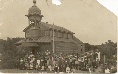
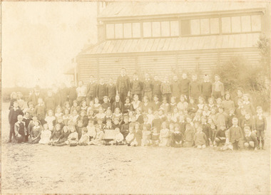
Photograph - Chelsea State School, Children outside Hoadleys Hall "Joss House", 1912
... ...Chelsea Primary School...Chelsea 3196 melbourne In January 1912, a small school was established at Chelsea, with 65 students, in Hoadley’s Hall, located on Main Road, Chelsea, near the Nepean Highway. Due to its Oriental appearance, the local people called this hall “The Joss House.” Hoadley's Hall was was originally used at the Melbourne Show Grounds by Hoadley's which was moved to Chelsea. The Hall was also used for church services by different religions before they built their own churches. A new brick school was built on Argyle Avenue and officially opened on 27 January 1915. Chelsea Education Chelsea Primary ...In January 1912, a small school was established at Chelsea, with 65 students, in Hoadley’s Hall, located on Main Road, Chelsea, near the Nepean Highway. Due to its Oriental appearance, the local people called this hall “The Joss House.” Hoadley's Hall was was originally used at the Melbourne Show Grounds by Hoadley's which was moved to Chelsea. The Hall was also used for church services by different religions before they built their own churches. A new brick school was built on Argyle Avenue and officially opened on 27 January 1915.Black and white photo of children at Chelsea State School, in 1912, standing in front of Hoadley's Hall.chelsea, education, chelsea primary school, school, hoadleys hall, joss house -
 Chelsea & District Historical Society Inc
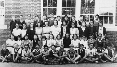
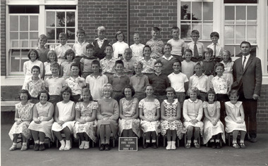
Photograph - Chelsea State School, Grade 7 & 8, 1950
... ...Chelsea Primary School...Chelsea & District Historical Society Inc The Chelsea Activity Hub 3-5 Showers Ave Chelsea 3196 melbourne Chelsea State School was built on Argyle Avenue and officially opened on 27 January 1915. Chelsea Education Chelsea Primary School school Grade 7 & 8 Black and white photo of Grade 7 & 8 children at Chelsea State School, in 1956 Grade 7 & 8 Photograph Chelsea State School ...Chelsea State School was built on Argyle Avenue and officially opened on 27 January 1915.Black and white photo of Grade 7 & 8 children at Chelsea State School, in 1956chelsea, education, chelsea primary school, school, grade 7 & 8 -
 Chelsea & District Historical Society Inc
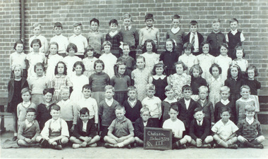
Photograph - Chelsea State School, Grade 3, 1941
... ...Chelsea Primary School...Chelsea & District Historical Society Inc The Chelsea Activity Hub 3-5 Showers Ave Chelsea 3196 melbourne Chelsea State School was built on Argyle Avenue and officially opened on 27 January 1915. Chelsea Education Chelsea Primary School school Grade 7 & 8 Black and white photo of Grade 3 children at Chelsea State School, in 1941 Grade 3 Photograph Chelsea State School ...Chelsea State School was built on Argyle Avenue and officially opened on 27 January 1915.Black and white photo of Grade 3 children at Chelsea State School, in 1941chelsea, education, chelsea primary school, school, grade 7 & 8 -
 Chelsea & District Historical Society Inc
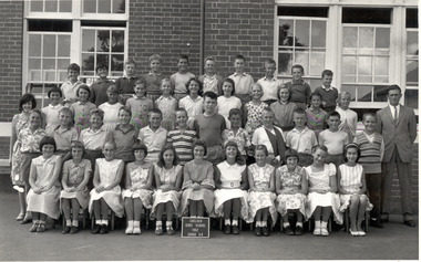
Photograph - Chelsea State School, Grade 6A, 1962
... ...Chelsea Primary School...Chelsea & District Historical Society Inc The Chelsea Activity Hub 3-5 Showers Ave Chelsea 3196 melbourne Chelsea State School was built on Argyle Avenue and officially opened on 27 January 1915. Chelsea Education Chelsea Primary School school Grade 6A Chelsea State School Black and White photo of Grade 6A at Chelsea State School, in 1962 Grade 6A Photograph Chelsea State School ...Chelsea State School was built on Argyle Avenue and officially opened on 27 January 1915.Black and White photo of Grade 6A at Chelsea State School, in 1962chelsea, education, chelsea primary school, school, grade 6a, chelsea state school -
 Chelsea & District Historical Society Inc
Photograph - Chelsea State School, Grade 6B, 1962
... ...Chelsea Primary School...Chelsea & District Historical Society Inc The Chelsea Activity Hub 3-5 Showers Ave Chelsea 3196 melbourne Chelsea State School was built on Argyle Avenue and officially opened on 27 January 1915. Chelsea Education Chelsea Primary School school Grade 6B Chelsea State School Black and white photo of Grade 6B at Chelsea State School, in 1962 Grade 6B Photograph Chelsea State School ...Chelsea State School was built on Argyle Avenue and officially opened on 27 January 1915.Black and white photo of Grade 6B at Chelsea State School, in 1962chelsea, education, chelsea primary school, school, grade 6b, chelsea state school -
 Chelsea & District Historical Society Inc
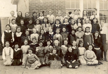
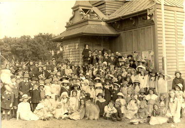
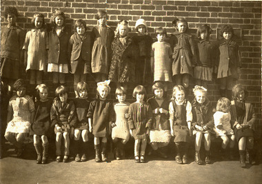
Photograph - Chelsea State School, Group of girls, 1917
... ...Chelsea Primary School...Chelsea & District Historical Society Inc The Chelsea Activity Hub 3-5 Showers Ave Chelsea 3196 melbourne Chelsea State School was built on Argyle Avenue and officially opened on 27 January 1915. Chelsea Education Chelsea Primary School school Chelsea State School Cupie Dolls Sepia photo of girls at Chelsea State School, in 1917. ...Chelsea State School was built on Argyle Avenue and officially opened on 27 January 1915.Sepia photo of girls at Chelsea State School, in 1917. Some of the girls are holding "Cupie Dolls"chelsea, education, chelsea primary school, school, chelsea state school, cupie dolls -
 Chelsea & District Historical Society Inc
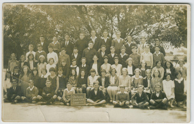
Photograph - Chelsea State School, Students at Kismet Hall, Chelsea, 1925
... ...Chelsea Primary School...Chelsea & District Historical Society Inc The Chelsea Activity Hub 3-5 Showers Ave Chelsea 3196 melbourne Chelsea State School was built on Argyle Avenue and officially opened on 27 January 1915. Kismet Hall was located in The Strand, Chelsea. Chelsea Education Chelsea Primary ...Chelsea State School was built on Argyle Avenue and officially opened on 27 January 1915. Kismet Hall was located in The Strand, Chelsea.Sepia photo of students of Chelsea State School, in front of Kismet Hall. The teacher is Miss Cooper. chelsea, education, chelsea primary school, school, chelsea state school, kismet hall -
 Chelsea & District Historical Society Inc
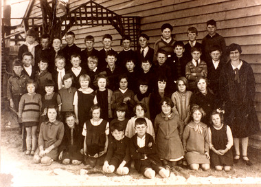
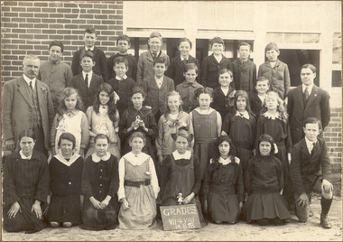
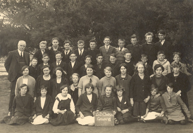
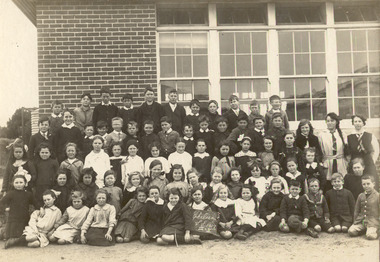
Photograph - Chelsea State School, Grades VII and VIII, c. 1920's
... ...Chelsea Primary School...Chelsea & District Historical Society Inc The Chelsea Activity Hub 3-5 Showers Ave Chelsea 3196 melbourne Chelsea State School was built on Argyle Avenue and officially opened on 27 January 1915. Chelsea Education Chelsea Primary School school Chelsea State School Sepia photo Grades VII and VIII, Chelsea State School, in 1920's. ...Chelsea State School was built on Argyle Avenue and officially opened on 27 January 1915.Sepia photo Grades VII and VIII, Chelsea State School, in 1920's. chelsea, education, chelsea primary school, school, chelsea state school -
 Chelsea & District Historical Society Inc
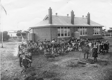
Photograph - Chelsea State School, Children and teachers in the yard of the school grounds, 1916
... ...Chelsea Primary School...Chelsea & District Historical Society Inc The Chelsea Activity Hub 3-5 Showers Ave Chelsea 3196 melbourne Chelsea State School was built on Argyle Avenue and officially opened on 27 January 1915. Chelsea Education Chelsea Primary School school Students school yard Chelsea State School Black and white photo of children and teachers in the yard of Chelsea State School, in 1916. ...Chelsea State School was built on Argyle Avenue and officially opened on 27 January 1915.Black and white photo of children and teachers in the yard of Chelsea State School, in 1916. Some Children are carrying gardening tools. chelsea, education, chelsea primary school, school, students, school yard, chelsea state school -
 Chelsea & District Historical Society Inc
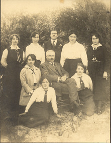
Photograph - Chelsea State School, Mr Rogers with staff and family, 1918
... ...Chelsea Primary School...Chelsea 3196 melbourne In January 1912, a small school was established at Chelsea, with 65 students, in Hoadley’s Hall, located on Main Road, Chelsea, near the Nepean Highway. Due to its Oriental appearance, the local people called this hall “The Joss House.” Hoadley's Hall was was originally used at the Melbourne Show Grounds by Hoadley's which was moved to Chelsea. The Hall was also used for church services by different religions before they built their own churches. Chelsea State School was built on Argyle Avenue and officially opened on 27 January 1915. Chelsea Education Chelsea Primary ...In January 1912, a small school was established at Chelsea, with 65 students, in Hoadley’s Hall, located on Main Road, Chelsea, near the Nepean Highway. Due to its Oriental appearance, the local people called this hall “The Joss House.” Hoadley's Hall was was originally used at the Melbourne Show Grounds by Hoadley's which was moved to Chelsea. The Hall was also used for church services by different religions before they built their own churches. Chelsea State School was built on Argyle Avenue and officially opened on 27 January 1915.Sepia photo of Mr Rogers, his staff and family. Mr Rogers was the first Head teacher of Chelsea State School from 1912 to 1917.chelsea, education, chelsea primary school, school, students, school yard, mr rogers, teachers, chelsea state school -
 Chelsea & District Historical Society Inc
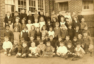
Photograph - Chelsea State School, Children outside Hoadleys Hall "Joss House", 1912
... ...Chelsea Primary School...Chelsea 3196 melbourne In January 1912, a small school was established at Chelsea, with 65 students, in Hoadley’s Hall, located on Main Road, Chelsea, near the Nepean Highway. Due to its Oriental appearance, the local people called this hall “The Joss House.” Hoadley's Hall was was originally used at the Melbourne Show Grounds by Hoadley's which was moved to Chelsea. The Hall was also used for church services by different religions before they built their own churches. A new brick school was built on Argyle Avenue and officially opened on 27 January 1915. Chelsea Education Chelsea Primary ...In January 1912, a small school was established at Chelsea, with 65 students, in Hoadley’s Hall, located on Main Road, Chelsea, near the Nepean Highway. Due to its Oriental appearance, the local people called this hall “The Joss House.” Hoadley's Hall was was originally used at the Melbourne Show Grounds by Hoadley's which was moved to Chelsea. The Hall was also used for church services by different religions before they built their own churches. A new brick school was built on Argyle Avenue and officially opened on 27 January 1915.Sepia photo of children and adults at Chelsea State School, in 1912, standing in front of Hoadley's Hall.chelsea, education, chelsea primary school, school, hoadleys hall, joss house, chelsea state school -
 Chelsea & District Historical Society Inc
Photograph - Chelsea State School, Children outside Hoadleys Hall "Joss House", 1914
... ...Chelsea Primary School...Chelsea 3196 melbourne In January 1912, a small school was established at Chelsea, with 65 students, in Hoadley’s Hall, located on Main Road, Chelsea, near the Nepean Highway. Due to its Oriental appearance, the local people called this hall “The Joss House.” Hoadley's Hall was was originally used at the Melbourne Show Grounds by Hoadley's which was moved to Chelsea. The Hall was also used for church services by different religions before they built their own churches. A new brick school was built on Argyle Avenue and officially opened on 27 January 1915. Chelsea Education Chelsea Primary ...In January 1912, a small school was established at Chelsea, with 65 students, in Hoadley’s Hall, located on Main Road, Chelsea, near the Nepean Highway. Due to its Oriental appearance, the local people called this hall “The Joss House.” Hoadley's Hall was was originally used at the Melbourne Show Grounds by Hoadley's which was moved to Chelsea. The Hall was also used for church services by different religions before they built their own churches. A new brick school was built on Argyle Avenue and officially opened on 27 January 1915.Sepia photo of children and adults at Chelsea State School, in 1914, standing in front of Hoadley's Hall.chelsea, education, chelsea primary school, school, hoadleys hall, joss house, chelsea state school -
 Chelsea & District Historical Society Inc
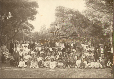
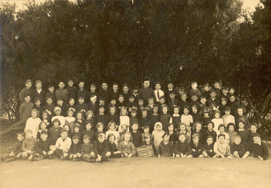
Photograph - Chelsea State School, Students, staff and Family on a picnic, c 1912-14
... ...Chelsea Primary School...Chelsea 3196 melbourne In January 1912, a small school was established at Chelsea, with 65 students, in Hoadley’s Hall, located on Main Road, Chelsea, near the Nepean Highway. Due to its Oriental appearance, the local people called this hall “The Joss House.” Hoadley's Hall was was originally used at the Melbourne Show Grounds by Hoadley's which was moved to Chelsea. The Hall was also used for church services by different religions before they built their own churches. A new brick school was built on Argyle Avenue and officially opened on 27 January 1915. Chelsea Education Chelsea Primary ...In January 1912, a small school was established at Chelsea, with 65 students, in Hoadley’s Hall, located on Main Road, Chelsea, near the Nepean Highway. Due to its Oriental appearance, the local people called this hall “The Joss House.” Hoadley's Hall was was originally used at the Melbourne Show Grounds by Hoadley's which was moved to Chelsea. The Hall was also used for church services by different religions before they built their own churches. A new brick school was built on Argyle Avenue and officially opened on 27 January 1915.Sepia photo of children, staff and family from Chelsea State School, at a picnic, amongst the te trees.chelsea, education, chelsea primary school, school, hoadleys hall, joss house, picnic, te trees -
 Chelsea & District Historical Society Inc
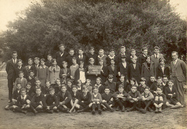
Photograph - Chelsea State School, Grade 7 & 8, 1928
... ...Chelsea Primary School...Chelsea & District Historical Society Inc The Chelsea Activity Hub 3-5 Showers Ave Chelsea 3196 melbourne Chelsea State School was built on Argyle Avenue and officially opened on 27 January 1915. Chelsea Education Chelsea Primary School school Chelsea State School grade 7 grade 8 Black and white photo of Grades 7 and 8 at Chelsea State School, in 1928 Grade 7 & 8 Photograph Chelsea State School ...Chelsea State School was built on Argyle Avenue and officially opened on 27 January 1915.Black and white photo of Grades 7 and 8 at Chelsea State School, in 1928chelsea, education, chelsea primary school, school, chelsea state school, grade 7, grade 8 -
 Chelsea & District Historical Society Inc
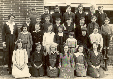
Photograph - Chelsea State School, Grade VII & VIII, 4 August 1918
... ...Chelsea Primary School...Chelsea & District Historical Society Inc The Chelsea Activity Hub 3-5 Showers Ave Chelsea 3196 melbourne Chelsea State School was built on Argyle Avenue and officially opened on 27 January 1915. Chelsea Education Chelsea Primary School school Chelsea State School grade 7 grade 8 Black and white photo of Mr G. ...Chelsea State School was built on Argyle Avenue and officially opened on 27 January 1915.Black and white photo of Mr G. Rogers, the Head Teacher, a male teacher, GradesVII and VIII at Chelsea State School, on 14 August 1918chelsea, education, chelsea primary school, school, chelsea state school, grade 7, grade 8 -
 Chelsea & District Historical Society Inc
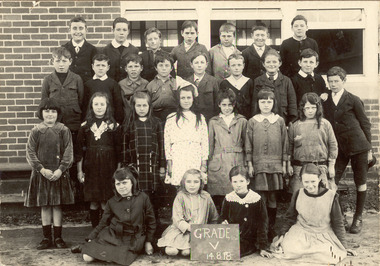
Photograph - Chelsea State School, Grade V, 4 August 1918
... ...Chelsea Primary School...Chelsea & District Historical Society Inc The Chelsea Activity Hub 3-5 Showers Ave Chelsea 3196 melbourne Chelsea State School was built on Argyle Avenue and officially opened on 27 January 1915. Chelsea Education Chelsea Primary School school Chelsea State School grade v Black and white photo of Grades V at Chelsea State School, on 14 August 1918 Back row: John Mullins, Charles Thibou, Leslie Payne, unknown, Lindsay Mercer, Tom Johnston, George Shillinglaw 2nd row: Roy O'Donnell, James Turner, Albert Thibou, Cecil Sandford, George Curl, Alfred Brain, Ernest Capp, Roy Porter, Cyril Ashmore 3rd row: Stella Staff, Mary Harkins, Lesley Green, Rose Hunter, Olive James, Hazel Allen, Florence Scott Sitting: Myrtle Barfoot, Jean Ambrose, Una Charman, Rita Ludford Grade V Photograph Chelsea State School ...Chelsea State School was built on Argyle Avenue and officially opened on 27 January 1915.Black and white photo of Grades V at Chelsea State School, on 14 August 1918 Back row: John Mullins, Charles Thibou, Leslie Payne, unknown, Lindsay Mercer, Tom Johnston, George Shillinglaw 2nd row: Roy O'Donnell, James Turner, Albert Thibou, Cecil Sandford, George Curl, Alfred Brain, Ernest Capp, Roy Porter, Cyril Ashmore 3rd row: Stella Staff, Mary Harkins, Lesley Green, Rose Hunter, Olive James, Hazel Allen, Florence Scott Sitting: Myrtle Barfoot, Jean Ambrose, Una Charman, Rita Ludford chelsea, education, chelsea primary school, school, chelsea state school, grade v -
 Chelsea & District Historical Society Inc
Photograph - Chelsea State School, Grade 8, 1921-22
... ...Chelsea Primary School...Chelsea & District Historical Society Inc The Chelsea Activity Hub 3-5 Showers Ave Chelsea 3196 melbourne Chelsea State School was built on Argyle Avenue and officially opened on 27 January 1915. Chelsea Education Chelsea Primary School school Chelsea State School grade 8 G Rogers Black and white photo of Mr G. ...Chelsea State School was built on Argyle Avenue and officially opened on 27 January 1915.Black and white photo of Mr G. Rogers, the Head Teacher, Grades 8 at Chelsea State School, 1921-22 Back row: Hazel Allen, Joyce Davis, Dorothy Craven, Lesley Green, Myrtle Willis, Vera Halford, Dorothy Dixie, Ivy Timewell, Una Charman, Mr G Rogers (Head Teacher) 2nd row: Florence Scott, Enid Carter, Ella Hawke, Phyllis Edhouse, Dorothy Stokes, Vera James 3rd row: - Brain, Fred Judd, Harry Blan, - Rogers, Tom Bickley, Bob Loveless, unknown, Charles McFarlane Front row: Alex Elder, James Turner, Bob Staff, Ray Jackson, Jack Johnston, Cliff Cumming, unknown, unknown chelsea, education, chelsea primary school, school, chelsea state school, grade 8, g rogers -
 Chelsea & District Historical Society Inc
Photograph - Chelsea State School, Grade 1 and 2
... ...Chelsea Primary School...Chelsea & District Historical Society Inc The Chelsea Activity Hub 3-5 Showers Ave Chelsea 3196 melbourne Chelsea State School was built on Argyle Avenue and officially opened on 27 January 1915. Chelsea Education Chelsea Primary School school Chelsea State School Grade 1 grade 2 Sepia photo of Grades 1 and 2 at Chelsea State School. ...Chelsea State School was built on Argyle Avenue and officially opened on 27 January 1915.Sepia photo of Grades 1 and 2 at Chelsea State School. chelsea, education, chelsea primary school, school, chelsea state school, grade 1, grade 2 -
 Chelsea & District Historical Society Inc
Photograph - Chelsea State School, Grade 3, c 1920's
... ...Chelsea Primary School...Chelsea & District Historical Society Inc The Chelsea Activity Hub 3-5 Showers Ave Chelsea 3196 melbourne Chelsea State School was built on Argyle Avenue and officially opened on 27 January 1915. Chelsea Education Chelsea Primary School school Chelsea State School grade 3 Sepia photo of Grade 3 at Chelsea State School. ...Chelsea State School was built on Argyle Avenue and officially opened on 27 January 1915.Sepia photo of Grade 3 at Chelsea State School. chelsea, education, chelsea primary school, school, chelsea state school, grade 3 -
 Chelsea & District Historical Society Inc
Photograph - Chelsea State School, Grade VI, 18 August 1918
... ...Chelsea Primary School...Chelsea & District Historical Society Inc The Chelsea Activity Hub 3-5 Showers Ave Chelsea 3196 melbourne Chelsea State School was built on Argyle Avenue and officially opened on 27 January 1915. Chelsea Education Chelsea Primary School school Chelsea State School Grade 6 Sepia photo of Grade 6 with a female teacher at Chelsea State School. ...Chelsea State School was built on Argyle Avenue and officially opened on 27 January 1915.Sepia photo of Grade 6 with a female teacher at Chelsea State School.chelsea, education, chelsea primary school, school, chelsea state school, grade 6 -
 Chelsea & District Historical Society Inc
Photograph - Chelsea State School, Grade VII, 1920's
... ...Chelsea Primary School...Chelsea & District Historical Society Inc The Chelsea Activity Hub 3-5 Showers Ave Chelsea 3196 melbourne Chelsea State School was built on Argyle Avenue and officially opened on 27 January 1915. Chelsea Education Chelsea Primary School school Chelsea State School Grade VII Mr Rogers Sepia photo of Grade ViII with a Mr Rogers, Head Teacher at Chelsea State School. ...Chelsea State School was built on Argyle Avenue and officially opened on 27 January 1915.Sepia photo of Grade ViII with a Mr Rogers, Head Teacher at Chelsea State School.chelsea, education, chelsea primary school, school, chelsea state school, grade vii, mr rogers -
 Chelsea & District Historical Society Inc
Photograph - Chelsea State School, Grades 3 and 4, 1917
... ...Chelsea Primary School...Chelsea & District Historical Society Inc The Chelsea Activity Hub 3-5 Showers Ave Chelsea 3196 melbourne Chelsea State School was built on Argyle Avenue and officially opened on 27 January 1915. Chelsea Education Chelsea Primary School school Chelsea State School Grade 3 Grade 4 Sepia photo of Grades 3 and 4 with two female teachers at Chelsea State School. ...Chelsea State School was built on Argyle Avenue and officially opened on 27 January 1915.Sepia photo of Grades 3 and 4 with two female teachers at Chelsea State School.chelsea, education, chelsea primary school, school, chelsea state school, grade 3, grade 4 -
 Chelsea & District Historical Society Inc
Photograph - Chelsea State School, A group of young girls, 1917
... ...Chelsea Primary School...Chelsea & District Historical Society Inc The Chelsea Activity Hub 3-5 Showers Ave Chelsea 3196 melbourne Chelsea State School was built on Argyle Avenue and officially opened on 27 January 1915. Chelsea Education Chelsea Primary School school Chelsea State School young girls Sepia photo of young girls at Chelsea State School. ...Chelsea State School was built on Argyle Avenue and officially opened on 27 January 1915.Sepia photo of young girls at Chelsea State School.chelsea, education, chelsea primary school, school, chelsea state school, young girls -
 Chelsea & District Historical Society Inc
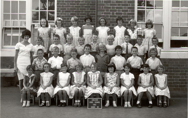
Photograph - Chelsea State School, Grade 3B, 1962
... ...Chelsea Primary School...Chelsea & District Historical Society Inc The Chelsea Activity Hub 3-5 Showers Ave Chelsea 3196 melbourne Chelsea State School was built on Argyle Avenue and officially opened on 27 January 1915. Chelsea Education Chelsea Primary School school Chelsea State School Grade 3B black and white photo of Grade 3B and a female teacher at Chelsea State School. ...Chelsea State School was built on Argyle Avenue and officially opened on 27 January 1915.black and white photo of Grade 3B and a female teacher at Chelsea State School.chelsea, education, chelsea primary school, school, chelsea state school, grade 3b -
 Chelsea & District Historical Society Inc
Photograph - Chelsea State School, Mothers and small children, 1922
... ...Chelsea Primary School...Chelsea & District Historical Society Inc The Chelsea Activity Hub 3-5 Showers Ave Chelsea 3196 melbourne Chelsea State School was built on Argyle Avenue and officially opened on 27 January 1915. Chelsea Education Chelsea Primary School school Chelsea State School mothers club Sepia photo of the mother's club and their small children at Chelsea State School. ...Chelsea State School was built on Argyle Avenue and officially opened on 27 January 1915.Sepia photo of the mother's club and their small children at Chelsea State School. Two people have been identified: Mrs Potter (back row 2nd left) Mrs Touzel (back row 4th left)chelsea, education, chelsea primary school, school, chelsea state school, mothers club -
 Chelsea & District Historical Society Inc
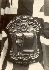
Photograph - Chelsea State School, Honour Roll World War 1, 1914
... ...Chelsea Primary School...Chelsea & District Historical Society Inc The Chelsea Activity Hub 3-5 Showers Ave Chelsea 3196 melbourne Chelsea State School was built on Argyle Avenue and officially opened on 27 January 1915. Chelsea Education Chelsea Primary School school Chelsea State School Honour board World War One WW1 CHELSEA STATE SCHOOL No3729 HONOURS W. ...Chelsea State School was built on Argyle Avenue and officially opened on 27 January 1915.Black and white photo of a plaque that honours soldiers from Chelsea State School. The plaque has a Soldier standing at attention and a scroll with the names.CHELSEA STATE SCHOOL No3729 HONOURS W. S. ROGERS L. BALL G. H. McINTOSH 1914 - ANZAC191 HONOR THE BRAVEchelsea, education, chelsea primary school, school, chelsea state school, honour board, world war one, ww1 -
 Chelsea & District Historical Society Inc
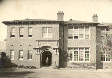
Photograph - Chelsea State School, 1920's
... ...Chelsea Primary School...Chelsea & District Historical Society Inc The Chelsea Activity Hub 3-5 Showers Ave Chelsea 3196 melbourne Chelsea State School was built on Argyle Avenue and officially opened on 27 January 1915. Chelsea Education Chelsea Primary School school Chelsea State School Mr Rogers Black and white photo of Chelsea State School. ...Chelsea State School was built on Argyle Avenue and officially opened on 27 January 1915.Black and white photo of Chelsea State School. Mr Rogers, the Head Teacher is standing in the doorway.chelsea, education, chelsea primary school, school, chelsea state school, mr rogers -
 Chelsea & District Historical Society Inc
Photograph - Chelsea State School, Mr Rogers, Head Teacher, 1917
... ...Chelsea Primary School...Chelsea & District Historical Society Inc The Chelsea Activity Hub 3-5 Showers Ave Chelsea 3196 melbourne Chelsea State School was built on Argyle Avenue and officially opened on 27 January 1915. Chelsea Education Chelsea Primary School school Chelsea State School Mr Rogers School playground Black and white photo of Chelsea State School playground. ...Chelsea State School was built on Argyle Avenue and officially opened on 27 January 1915.Black and white photo of Chelsea State School playground. Mr Rogers, the Head Teacher is standing next to a picket fence.chelsea, education, chelsea primary school, school, chelsea state school, mr rogers, school playground -
 Chelsea & District Historical Society Inc
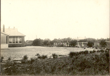
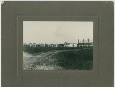
Photograph - Chelsea State School, Rear view of the school, 1917
... ...Chelsea Primary School...Chelsea & District Historical Society Inc The Chelsea Activity Hub 3-5 Showers Ave Chelsea 3196 melbourne Chelsea State School was built on Argyle Avenue and officially opened on 27 January 1915. Chelsea Education Chelsea Primary School school Chelsea State School Mr Rogers School playground Black and white photo of Chelsea State School playground and the rear of the school building taken from corner of Fowler St and Glenola Road, showing unmade roads. ...Chelsea State School was built on Argyle Avenue and officially opened on 27 January 1915.Black and white photo of Chelsea State School playground and the rear of the school building taken from corner of Fowler St and Glenola Road, showing unmade roads.chelsea, education, chelsea primary school, school, chelsea state school, mr rogers, school playground -
 Chelsea & District Historical Society Inc
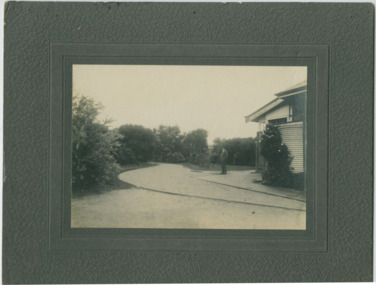
Photograph - Chelsea State School, The garden, 1921
... ...Chelsea Primary School...Chelsea & District Historical Society Inc The Chelsea Activity Hub 3-5 Showers Ave Chelsea 3196 melbourne Chelsea State School was built on Argyle Avenue and officially opened on 27 January 1915. Chelsea Education Chelsea Primary School school Chelsea State School Mr Rogers School playground Black and white photo of Mr G Rogers, Head Teacher, in foreground viewing garden area at Chelsea State School. ...Chelsea State School was built on Argyle Avenue and officially opened on 27 January 1915.Black and white photo of Mr G Rogers, Head Teacher, in foreground viewing garden area at Chelsea State School. Three female teachers in background. chelsea, education, chelsea primary school, school, chelsea state school, mr rogers, school playground