Showing 18 items matching "chelsea railway station"
-
 Chelsea & District Historical Society Inc
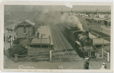
Photograph - Chelsea Railway Station, 1915 - 1922
... Chelsea Railway Station...Chelsea...Steam Train...Tait carriages...Frankston Railway Line...Chelsea Railway station...Chelsea station opened on 4 February 1907 as a single platform stopping station, on a single railway line to Frankston, which was laid in 1882. ...Two black and white postcards of Chelsea Railway station. P000113 Show a steam engine pulling the Swing Door carriages at the station....Photograph Chelsea Railway Station ...Chelsea station opened on 4 February 1907 as a single platform stopping station, on a single railway line to Frankston, which was laid in 1882. The double line was introduced in December 1910, and the station expanded to two platforms. In 1922 the railway line was electrified. Two black and white postcards of Chelsea Railway station. P000113 Show a steam engine pulling the Swing Door carriages at the station."Chelsea 53"chelsea, steam train, tait carriages, frankston railway line, chelsea railway station -
 Chelsea & District Historical Society Inc
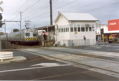
Photograph - Chelsea Railway Station, 1990
... Chelsea Railway Station...Chelsea station opened on 4 February 1907 as a single platform stopping station, on a single railway line to Frankston, which was laid in 1882. ...Two coloured photos of Chelsea Railway station....Photograph Chelsea Railway Station ...Chelsea station opened on 4 February 1907 as a single platform stopping station, on a single railway line to Frankston, which was laid in 1882. The double line was introduced in December 1910, and the station expanded to two platforms. In 1922 the railway line was electrified. Two coloured photos of Chelsea Railway station.chelsea, frannkston railway line, electric train -
 Chelsea & District Historical Society Inc
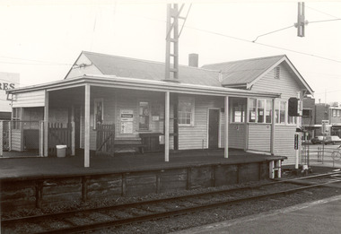
Photograph - Chelsea Railway Station, 1993
... Chelsea Railway Station...Chelsea station opened on 4 February 1907 as a single platform stopping station, on a single railway line to Frankston, which was laid in 1882. ...Four black and white photos of Chelsea Railway station. P01067: Chelsea Railway Station showing office on Melbourne side of station (west); P01068: An electric train (Harris Train also known as the "Blue Train") stationary at Chelsea Station; P 01069: Chelsea railway station showing down side (Frankston) office building; P01070: Chelsea Railway Station office, taken from the ramp on the west side of line....Photograph Chelsea Railway Station ...Chelsea station opened on 4 February 1907 as a single platform stopping station, on a single railway line to Frankston, which was laid in 1882. The double line was introduced in December 1910, and the station expanded to two platforms. In 1922 the railway line was electrified. Four black and white photos of Chelsea Railway station. P01067: Chelsea Railway Station showing office on Melbourne side of station (west); P01068: An electric train (Harris Train also known as the "Blue Train") stationary at Chelsea Station; P 01069: Chelsea railway station showing down side (Frankston) office building; P01070: Chelsea Railway Station office, taken from the ramp on the west side of line.chelsea, electric train, frankston railway line, harris train, blue train -
 City of Kingston
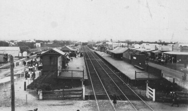
Photograph - Digital image, Black and white, c. 1910
... Chelsea...Railway station...Black and white image of Chelsea Railway Station showing the impact of the railways on the development of the area. ...Black and white image of Chelsea Railway Station showing platforms and local shops...City of Kingston Parkdale Library 96 Parkers Road, Parkdale Parkdale Black and white image of Chelsea Railway Station showing the impact of the railways on the development of the area. ...Black and white image of Chelsea Railway Station showing the impact of the railways on the development of the area. Shops and shoppers can be seen behind the station buildings.The extension of the railway line from Mordialloc to Frankston influenced the development of the villages along the train line. Shops and community buildings were built in proximity to the station, along with the subdivision of land for houses. Black and white image of Chelsea Railway Station showing platforms and local shopschelsea, railway station, railway, shopping strip, public transport -
 Chelsea & District Historical Society Inc
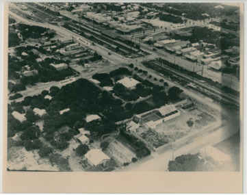
Photograph - Aerial Photo of Chelsea, c 1923
... Chelsea...Aerial photo...Station Street...Chelsea Road...The Strand...Bath Street...Fox Theatre...Masons Theatre...W. H. Hansom...Chelsea Railway...Points of interest in the photo are Fox Theatre, Chelsea Railway Station and the building site of Masons Theatre on the corner of Chelsea Road and Station Street. ...Chelsea Aerial photo Station Street Chelsea Road The Strand Bath Street Fox Theatre Masons Theatre W. H. Hansom Chelsea Railway ...Points of interest in the photo are Fox Theatre, Chelsea Railway Station and the building site of Masons Theatre on the corner of Chelsea Road and Station Street. Mr William Herbert Hansom was a pioneer of aerial photography in Australia.Black and white aerial photo of Chelsea, bordered by Thames Promenade, Balantyne Avenue, Catherine Avenue and Chelsea Road, Station Street, The Strand, Bath Street.W. H. Hansom ("Manders") Aerial Artist, Personally Conducted Flights over Melbourne and Suburbs St James' Building Bourke Street, Melbournechelsea, aerial photo, station street, chelsea road, the strand, bath street, fox theatre, masons theatre, w. h. hansom, chelsea railway station -
 Chelsea & District Historical Society Inc
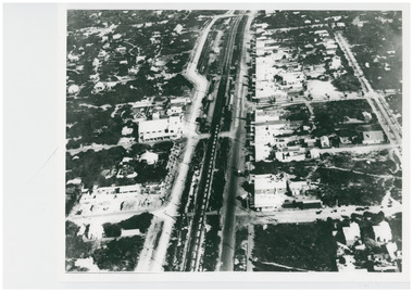
Photograph - Aerial Photo of Chelsea, c 1923
... Chelsea...Aerial photo...Station Street...Chelsea Road...The Strand...Bath Street...Fox Theatre...Masons Theatre...Chelsea Railway...Points of interest in the photo are Fox Theatre in Station Street and Masons Theatre on the corner of Chelsea Road and Station Street; Chelsea Railway Station with a goods train going past. ...Chelsea & District Historical Society Inc The Chelsea Activity Hub 3-5 Showers Ave Chelsea 3196 melbourne Points of interest in the photo are Fox Theatre in Station Street and Masons Theatre on the corner of Chelsea Road and Station Street; Chelsea Railway Station with a goods train going past. ...Points of interest in the photo are Fox Theatre in Station Street and Masons Theatre on the corner of Chelsea Road and Station Street; Chelsea Railway Station with a goods train going past. Street in photo are Station Street, Chelsea Road, Nepean Highway, Thames Promenade, Bath Street and The Strand. Black and white aerial photo of Chelsea. chelsea, aerial photo, station street, chelsea road, the strand, bath street, fox theatre, masons theatre, chelsea railway station, thames promenade, nepean highway -
 Chelsea & District Historical Society Inc
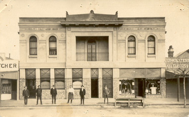
Photograph - Chelsea Shops, Butcher shop - Chelsea Wine Bar - Upholsterer, 1920's
... The Chelsea Wine Cafe was situated in Point Nepean Highway opposite the Chelsea railway station. It offered meals, accommodation and wine. ...Chelsea & District Historical Society Inc The Chelsea Activity Hub 3-5 Showers Ave Chelsea 3196 melbourne The Chelsea Wine Cafe was situated in Point Nepean Highway opposite the Chelsea railway station. It offered meals, accommodation and wine. ...The Chelsea Wine Cafe was situated in Point Nepean Highway opposite the Chelsea railway station. It offered meals, accommodation and wine. In late 1936 the building was pulled down.Two black and white photos of Chelsea Wine Cafe also in the photos are a butcher shop and an upholsterer.Chelsea Wine Cafe Cash Butcher Upholsterer - All classes of Furniture chelsea, chelsea wine cafe, point nepean road, nepean highway -
 Chelsea & District Historical Society Inc
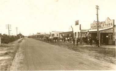
Photograph - Point Nepean Road, Chelsea
... Black and white photo of Chelsea, showing Point Nepean Road, the railway line, people, shops, horse and cart and bicycles. Chelsea Railway Station can be seen in the distance. ...Chelsea & District Historical Society Inc The Chelsea Activity Hub 3-5 Showers Ave Chelsea 3196 melbourne Chelsea Point Nepean Road Nepean Highway railway Black and white photo of Chelsea, showing Point Nepean Road, the railway line, people, shops, horse and cart and bicycles. Chelsea Railway Station ...Black and white photo of Chelsea, showing Point Nepean Road, the railway line, people, shops, horse and cart and bicycles. Chelsea Railway Station can be seen in the distance. Shops that can be identifies are the Chelsea General Store, J & C Caudwell and Timber Merchant.chelsea, point nepean road, nepean highway, railway -
 City of Moorabbin Historical Society (Operating the Box Cottage Museum)
Newsletter, City of Moorabbin Historical Society Apr 2008, April 2008
... chelsea...cheltenham...ormond...bentleigh...market gardeners...pioneers...early settlers...moorabbin shire...sheehy tom...whitehead dr graham...box cottage museum...highett...bent thomas...moorabbin news cheltenham...epsom race course cheltenham...victoria...fletcher n...fiander mrs....puttick george...moorabbin co-operative society ltd....hay h....freeman j.w....montanjees m....royal oak hotel...rose m.a....matthews j.t....hewett h....cope and dow builders...market gardeners and fruit-growers association...proudman e.w....benjamin m.e....edwards t.a....solicitors...pharmacy...butchers...bootmakers...bakers...hairdressers...barbers...house painters...grocers...publicans...drapers...craftsmen...members of parliament...valuers...moule w.h....argus newspaper...coachbuilders...cheltenham railway station...Tom Sheehy, past President of CMHS, was an Historian and Author of ‘Battlers Tamed the Sandbelt’. city of moorabbin historical society stanley helen melbourne moorabbin brighton chelsea cheltenham ormond bentleigh market gardeners pioneers early settlers moorabbin shire sheehy tom whitehead dr graham box cottage museum highett bent thomas moorabbin news cheltenham epsom race course cheltenham victoria fletcher n fiander mrs. puttick george moorabbin co-operative society ltd. hay h. freeman j.w. montanjees m. royal oak hotel rose m.a. matthews j.t. hewett h. cope and dow builders market gardeners and fruit-growers association proudman e.w. benjamin m.e. edwards t.a. solicitors pharmacy butchers bootmakers bakers hairdressers barbers house painters grocers publicans drapers craftsmen members of parliament valuers moule w.h. argus newspaper coachbuilders cheltenham railway station victoria thompson w. post office CITY of MOORABBIN HISTORICAL SOCIETY / APRIL 2008 NEWSLETTER A4 paper printed both sides x1. ...The City of Moorabbin Historical Society was formed c 1960 by a group of Moorabbin residents who were concerned that the history of the area should be preserved. A good response to a call for items related to the historical area of Moorabbin Shire brought donations of a wide variety of artefacts which are now preserved by the current members of CMHS at Box Cottage Museum . Helen Stanley, Secretary of CMHS, began producing a Newsletter for members in April 2007 to provide current information and well researched items of historical interest.Helen Stanley has produced a bi-monthly Newsletter, 2007 - 2013, for the members of the City of Moorabbin Historical Society that contains well researched interesting historical items, notification of upcoming events, current advice from Royal Australian Historical Society , Museums Australia Victoria and activities of Local Historical Societies. The Newsletter is an important record of the activities of the CMHS. Tom Sheehy, past President of CMHS, was an Historian and Author of ‘Battlers Tamed the Sandbelt’. A4 paper printed both sides x1. Issue 6 of the bi-monthly, City of Moorabbin Historical Society Newsletter produced by Society member and Secretary, Mrs Helen Stanley in April 2008. Notice of Dr G Whitehead talk , titled ‘Murder” on April 27th and Subscription fees due. Another excerpt from the CMHS August 1963,, by Tom Sheehy, President, ‘This is the News of the early twentieth century…’.The ‘Moorabbin News “ began in April 1900. Tommy Bent was elected to State Parliament, horse races at Epsom Course Cheltenham, and the development of Cheltenham as many businesses set up ‘opposite the Station’. ‘The Mechanics Institute and Temperance Hall and the Exchange Hotel faced one another in defiance’ CITY of MOORABBIN HISTORICAL SOCIETY / APRIL 2008 NEWSLETTERcity of moorabbin historical society, stanley helen, melbourne, moorabbin, brighton, chelsea, cheltenham, ormond, bentleigh, market gardeners, pioneers, early settlers, moorabbin shire, sheehy tom, whitehead dr graham, box cottage museum, highett, bent thomas, moorabbin news cheltenham, epsom race course cheltenham, victoria, fletcher n, fiander mrs., puttick george, moorabbin co-operative society ltd., hay h., freeman j.w., montanjees m., royal oak hotel, rose m.a., matthews j.t., hewett h., cope and dow builders, market gardeners and fruit-growers association, proudman e.w., benjamin m.e., edwards t.a., solicitors, pharmacy, butchers, bootmakers, bakers, hairdressers, barbers, house painters, grocers, publicans, drapers, craftsmen, members of parliament, valuers, moule w.h., argus newspaper, coachbuilders, cheltenham railway station victoria, thompson w., post office -
 City of Moorabbin Historical Society (Operating the Box Cottage Museum)
Newsletter, City of Moorabbin Historical Society Jun 2008, June 2008
... chelsea...cheltenham...ormond...bentleigh...market gardeners...pioneers...early settlers...moorabbin shire...sheehy tom...box cottage museum...highett...cheltenham railway station...Tom Sheehy, past President of CMHS, was an Historian and Author of ‘Battlers Tamed the Sandbelt’. city of moorabbin historical society stanley helen melbourne moorabbin brighton chelsea cheltenham ormond bentleigh market gardeners pioneers early settlers moorabbin shire sheehy tom box cottage museum highett cheltenham railway station victoria mccarthy jack power maurice j. charman road state school standard certificate education cheltenham post office point nepean road sports moorabbin show processions parades mentone ice skating rink sheperd’s café bourke street horse tram sandringham beach road ss hygeia ss courier ss edina mechanics hall memorial hall magic lantern shows crooks mr. engine drivers strike 1903 park road cheltenham booth dorothy mentone railway station gardens CITY of MOORABBIN HISTORICAL SOCIETY / JUNE 2008 NEWSLETTER A4 paper printed both sides x1. ...The City of Moorabbin Historical Society was formed c 1960 by a group of Moorabbin residents who were concerned that the history of the area should be preserved. A good response to a call for items related to the historical area of Moorabbin Shire brought donations of a wide variety of artefacts which are now preserved by the current members of CMHS at Box Cottage Museum . Helen Stanley, Secretary of CMHS, began producing a Newsletter for members in April 2007 to provide current information and well researched items of historical interest.Helen Stanley has produced a bi-monthly Newsletter, 2007 - 2013, for the members of the City of Moorabbin Historical Society that contains well researched interesting historical items, notification of upcoming events, current advice from Royal Australian Historical Society , Museums Australia Victoria and activities of Local Historical Societies. The Newsletter is an important record of the activities of the CMHS. Tom Sheehy, past President of CMHS, was an Historian and Author of ‘Battlers Tamed the Sandbelt’. A4 paper printed both sides x1. Issue 7 of the bi-monthly, City of Moorabbin Historical Society Newsletter produced by Society member and Secretary, Mrs Helen Stanley in June 2008. Notice for meeting June 29th and August 31st at which Ms Dorothy Booth’s topic will be ‘The Historical Mentone Railway Gardens’. Another excerpt from the CMHS Newsletter November 1965, by Tom Sheehy, President, called ‘Memories of Old Cheltenham’ This is the story ‘as told’ to Tom Sheehy by Jack McCarthy b 1890, a member of CMHS, and includes a photocopied photograph of passengers on SS Hygeia c 1900 on a trip across the Bay to the Geelong area. CITY of MOORABBIN HISTORICAL SOCIETY / JUNE 2008 NEWSLETTERcity of moorabbin historical society, stanley helen, melbourne, moorabbin, brighton, chelsea, cheltenham, ormond, bentleigh, market gardeners, pioneers, early settlers, moorabbin shire, sheehy tom, box cottage museum, highett, cheltenham railway station victoria, mccarthy jack, power maurice j., charman road state school, standard certificate education, cheltenham post office, point nepean road, sports, moorabbin show, processions, parades, mentone ice skating rink, sheperd’s café, bourke street, horse tram, sandringham, beach road, ss hygeia, ss courier, ss edina, mechanics hall, memorial hall, magic lantern shows, crooks mr., engine drivers strike 1903, park road cheltenham, booth dorothy, mentone railway station gardens -
 Chelsea & District Historical Society Inc
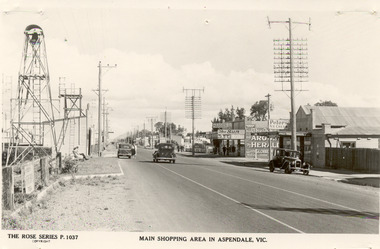
Photograph - Shopping Area, Aspendale, c 1930's
... Chelsea & District Historical Society Inc The Chelsea Activity Hub 3-5 Showers Ave Chelsea 3196 melbourne Point Nepean Road Nepean Highway Aspendale Taylor Avenue shops Aspendale fire station Aspendale Picnic Grounds The Rose Series P. 1037 MAIN SHOPPING AREA IN ASPENDALE, VIC. Black and white postcard showing shops on the right hand side of Point Nepean Road and the railway ...Black and white postcard showing shops on the right hand side of Point Nepean Road and the railway line, Aspendale railway station and the Aspendale Fire Station with the bell tower beside it. One car driving along the road and two cars parked. The shops in view are a cafe, a general store, the Aspendale Picnic Grounds, which included Palais De Dance.The Rose Series P. 1037 MAIN SHOPPING AREA IN ASPENDALE, VIC.point nepean road, nepean highway, aspendale, taylor avenue, shops, aspendale fire station, aspendale picnic grounds -
 Chelsea & District Historical Society Inc
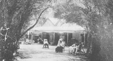
Photograph - Chalet at Aspendale, 1910
... Chelsea & District Historical Society Inc The Chelsea Activity Hub 3-5 Showers Ave Chelsea 3196 melbourne The Aspendale Chalet was about 18 miles from Melbourne between the railway station and the beach. ...The Aspendale Chalet was about 18 miles from Melbourne between the railway station and the beach. It was a seaside "resort" where people could camp amongst the ti-trees. In 1911, the Chalet was subdivided and the blocks were sold.Four guest sitting on deck chairs in the Chalet gardens.chalet, aspendale, holidays -
 Chelsea & District Historical Society Inc
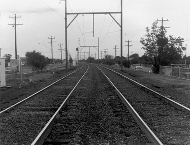
Photograph - Frankston Railway Line, Chelsea, 1993
... Chelsea station opened on 4 February 1907 as a single platform stopping station, on a single railway line to Frankston, which was laid in 1882. ...Chelsea & District Historical Society Inc The Chelsea Activity Hub 3-5 Showers Ave Chelsea 3196 melbourne Chelsea station opened on 4 February 1907 as a single platform stopping station, on a single railway line to Frankston, which was laid in 1882. ...Chelsea station opened on 4 February 1907 as a single platform stopping station, on a single railway line to Frankston, which was laid in 1882. The double line was introduced in December 1910, and the station expanded to two platforms. In 1922 the railway line was electrified. Black and white photos of Frankston Railway Line, taken at Chelsea looking north from Argyle Street Crossing. chelsea, electric train, frankston railway line -
 Chelsea & District Historical Society Inc
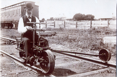
Photograph - Mordialloc Railway Station, Mr Pain, Railway Ganger, late 1860's
... Chelsea & District Historical Society Inc The Chelsea Activity Hub 3-5 Showers Ave Chelsea 3196 melbourne Mordialloc Railway railway ganger railway tricycle Tait carriages Black and white photo of a railway ganger, Mr Price, riding a railway tricycle at Mentone Station. ...Black and white photo of a railway ganger, Mr Price, riding a railway tricycle at Mentone Station. In the background are a "Swing Door" carriage and in the distance two houses.mordialloc, railway, railway ganger, railway tricycle, tait carriages -
 City of Kingston
Photograph - Colour, 29 January 1993
... railway station. From 1906 until the late 1940s sand was quarried on the east side of the railway line and used in the manufacture of glass. The Australian Glass Manufacturers sold this land in residential blocks and Bonbeach's permanent population spread from the coastal strip across to the other side of the railway line. Bonbeach Chelsea ...Bonbeach is a small beachside suburb located between Chelsea and Carrum. The station was opened in 1926 and was the last to be established in the group from Aspendale to Carrum. Urban growth began after World War II. State primary and high schools were opened in 1958 on land in Breeze Street that was once occupied by The Australian Glass Manufacturers. Immediately east of the school sites is the Patterson River Golf Club. The Bonbeach sports reserve has five ovals and is home to the Bonbeach football and baseball clubs. The suburb borders the Edithvale-Seaford Wetlands which is the remnant site of the Carrum Carrum swamp, once the home of the Bunurong people.Bonbeach was originally a seaside destination for holidaymakers and the housing comprised of holiday homes and gradually more permanent residents. It was not until 1926 that Bonbeach had its own railway station. From 1906 until the late 1940s sand was quarried on the east side of the railway line and used in the manufacture of glass. The Australian Glass Manufacturers sold this land in residential blocks and Bonbeach's permanent population spread from the coastal strip across to the other side of the railway line. Laminated colour aerial photograph of the suburb of Bonbeach and also the southern section of neighbouring Chelsea within the City of Kingston. The extent of this 1993 aerial image includes: Top left - Maury Road at the south end of the Chelsea shopping Centre; Top right - Scotch Parade Chelsea Bottom left - Monica Avenue in Bonbeach; Bottom right - Patterson River Golf Club. Landmarks include St Joseph's Church and Primary School, Chelsea Primary School, Bonbeach Station, Bonbeach Fotball Club sports playing fields and Bonbeach Life Saving Club. The Edithvale Wetlands is featured prominently to the right-hand side of the image. Black typed writing on white adhesive label: No. 6662 Black typed writing on white adhesive label: 26E/6662, 29/1/93, 4.25 pm Black typed writing on white adhesive label: 29-1-93 Black typed writing on white adhesive label: P000109 Circular yellow adhesive sticker bonbeach, chelsea -
City of Kingston
Photograph - Colour, Circa 1993
... Chelsea/Edithvale in the south. The area is built-up with residential housing and facilities including Edithvale Primary School, numerous churches and the Edithvale Railway station. ...Chelsea/Edithvale in the south. The area is built-up with residential housing and facilities including Edithvale Primary School, numerous churches and the Edithvale Railway station. ...Edithvale is a suburb in the City of Kingston. It is located between Aspendale and Chelsea on the Port Phillip Bay and built within remnant areas of the Carrum Carrum swamp. The foreshore precinct comprises a wide sandy beach, with low sand dunes and numerous historic boat sheds. The suburb consists of older style dwellings and former holiday houses, combined with mid-century housing and newer homes. The large blocks are increasingly subdivided and the existing dwellings demolished to accommodate units and townhouses, thus changing the landscape of the area and reducing the tree canopy.The beachside suburb of Edithvale was previously part of the extensive Carrum Carrum Swamp. The area was once a source of fish and eels for the Mayone-Bulluk clan of the Bunurong people. Over time the area was drained and predominantly devoted to dairy farming and holiday houses. The farms were gradually sold and subdivided with a large number of homes built after World War II and in the 1960s. Edithvale is mainly residential with a shopping strip along Nepean Highway but little significant industry was ever established in the area apart from a plaster works and confectionary factory, both now closed.Aerial colour photograph of Edithvale as viewed from Alexandra Avenue in the north to Ella Grove Chelsea/Edithvale in the south. The area is built-up with residential housing and facilities including Edithvale Primary School, numerous churches and the Edithvale Railway station. Large sections depict the remnant Carrum Carrum swamp. Edithvale Common and the former "Duck Inn" (Melbourne Water/Friends of Edithvale Seaford Wetlands) can be seen. Edithvale Recreational reserve, the velodrome and Edithvale Public Golf Course are prominent. The image shows vacant land in the area now known as Aspendale Gardens and the newer residential section of Chelsea Heights is not developed. A bike path has been established to cover the secondary drain. The Golf Links Court residential development located off Hughes Avenue is a large vacant block.Yellow circular adhesive sticker on plastic Black ink (marker): * (asterisk) Black type on white adhesive sticker: P000108edithvale, aspendale, chelsea, carrum carrum swamp -
City of Kingston
Photograph - Colour, 6 March 1993
... Chelsea/Edithvale in the south. regents Park Aspendale can be seen in the top left. The area is built-up with residential housing and facilities including Edithvale Primary School, numerous churches and the Edithvale Railway station. ...Chelsea/Edithvale in the south. regents Park Aspendale can be seen in the top left. The area is built-up with residential housing and facilities including Edithvale Primary School, numerous churches and the Edithvale Railway station. ...Edithvale is a suburb in the City of Kingston. It is located between Aspendale and Chelsea on the Port Phillip Bay and built within remnant areas of the Carrum Carrum swamp. The foreshore precinct comprises a wide sandy beach, with low sand dunes and numerous historic boat sheds. The suburb consists of older style dwellings and former holiday houses, combined with mid-century housing and newer homes. The large blocks are increasingly subdivided and the existing dwellings demolished to accommodate units and townhouses, thus changing the landscape of the area and reducing the tree canopy.The beachside suburb of Edithvale was previously part of the extensive Carrum Carrum Swamp. The area was once a source of fish and eels for the Mayone-Bulluk clan of the Bunurong people. Over time the area was drained and predominantly devoted to dairy farming and holiday houses. The farms were gradually sold and subdivided with a large number of homes built after World War II and in the 1960s. Edithvale is mainly residential with a shopping strip along Nepean Highway but little significant industry was ever established in the area apart from a plaster works and confectionary factory, both now closed.Laminated aerial colour photograph of Edithvale as viewed from Alexandra Avenue in the north to Ella Grove Chelsea/Edithvale in the south. regents Park Aspendale can be seen in the top left. The area is built-up with residential housing and facilities including Edithvale Primary School, numerous churches and the Edithvale Railway station. Large sections depict the remnant Carrum Carrum swamp. Edithvale Common and the former "Duck Inn" (Melbourne Water/Friends of Edithvale Seaford Wetlands) can be seen. Edithvale Recreational reserve, the valodrome and Edithvale Public Golf Course are prominent. The image shows vacant land in the area now known as Aspendale Gardens and the newer residential section of Chelsea Heights is not developed. A bike path has been established to cover the secondary drain. The Golf Links Court residential development located off Hughes Avenue is a large vacant block.Black type on white adhesive label: 6-3-93 Black type on white adhesive label: 25/9211, 6/3/93, 11.20 am Black type on white adhesive label: 9211 Yellow circular adhesive sticker Black pencil: 9211 6-3-93 arrow pointing Nedthvale, carrum carrum swamp, aspendale, chelsea -
 Melbourne Tram Museum
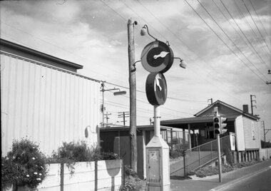
Negative - Marshalite traffic light Nepean Highway, Hugh Ballment, c1954
... The photograph shows a Marshalite traffic signal at a railway station along the Frankston line - such signals were provided at Chelsea, Bonbeach and Aspendale....Melbourne Tram Museum 8 Wallen Road Hawthorn melbourne The photograph shows a Marshalite traffic signal at a railway station along the Frankston line - such signals were provided at Chelsea, Bonbeach and Aspendale. ...The photograph shows a Marshalite traffic signal at a railway station along the Frankston line - such signals were provided at Chelsea, Bonbeach and Aspendale.Yields information about the Marshalite traffic lights installed at ? station.Negative - 127 film black and whitetraffic lights, marshalite, railways, nepean highway