Showing 22 items matching "circular router"
-
 Flagstaff Hill Maritime Museum and Village
Tool - Router
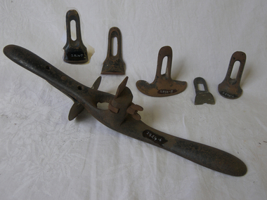
... ...circular router...Router; Patent, Adjustable Circular Quirk or Grooving Router. ...Flagstaff Hill Maritime Museum and Village 89 Merri Street Warrnambool great-ocean-road flagstaff hill warrnambool shipwrecked coast flagstaff hill maritime museum maritime museum shipwreck coast flagstaff hill maritime village great ocean road router hand router circular router Router; Patent, Adjustable Circular Quirk or Grooving Router. ...Router; Patent, Adjustable Circular Quirk or Grooving Router. All metal. It has six fences.flagstaff hill, warrnambool, shipwrecked coast, flagstaff hill maritime museum, maritime museum, shipwreck coast, flagstaff hill maritime village, great ocean road, router, hand router, circular router -
 Hand Tool Preservation Association of Australia Inc
Router
... router, circular, sash lambstongue...Hand Tool Preservation Association of Australia Inc No physical address melbourne This item is part of the Thomas Caine Tool Collection, owned by The National Trust of Australia (Victoria) and curated by the Hand Tools Preservation Association of Australia. router, circular, sash lambstongue Router ...This item is part of the Thomas Caine Tool Collection, owned by The National Trust of Australia (Victoria) and curated by the Hand Tools Preservation Association of Australia.router, circular, sash lambstongue -
 Melbourne Tram Museum
Ephemera - Timetables - The Met - buses - set of 2, The Met, 1984 and 1985
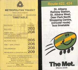
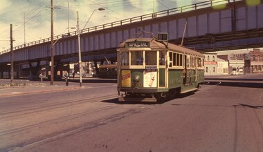
... Timetables - provide information on ticketing, fares, timing points, with a description of the route and a map. 1 - Bulleen - North Kew - City, Belford Rd, Collingwood - routes 203, 204, 205, 206, 208, 209 - with the first "The Met" logo - April 1984 2 - St Albans - Deer Park North Shopping Centre - circular route - with the smiley face on wheels logo - dated 18/3/1985....Melbourne Tram Museum 8 Wallen Road Hawthorn melbourne Timetables - provide information on ticketing, fares, timing points, with a description of the route and a map. 1 - Bulleen - North Kew - City, Belford Rd, Collingwood - routes 203, 204, 205, 206, 208, 209 - with the first "The Met" logo - April 1984 2 - St Albans - Deer Park North Shopping Centre - circular route - with the smiley face on wheels logo - dated 18/3/1985. ...Timetables - provide information on ticketing, fares, timing points, with a description of the route and a map. 1 - Bulleen - North Kew - City, Belford Rd, Collingwood - routes 203, 204, 205, 206, 208, 209 - with the first "The Met" logo - April 1984 2 - St Albans - Deer Park North Shopping Centre - circular route - with the smiley face on wheels logo - dated 18/3/1985.Yields information about MMTB Bus services during the mid 1980s. Set of two The Met timetables, one printed on the folded sheet of yellow paper and the other on white paper.timetable, bulleen, north kew, collingwood, the met, deer park, st albans -
 Melbourne Tram Museum
Ephemera - Timetable, Prahran & Malvern Tramway Trust (PMTT), "The Prahran and Malvern Tramway Trust's Official Time Table", Jul. 1918
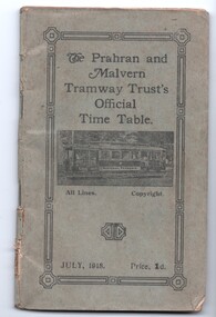
... routes, fares, signs, notices, tickets and details of the Combined round trips by tram. Has advertisements for Anderson's Furniture of Chapel St Prahran and E. Crook Men's Boys and Boots Chapel St, South Yarra. Map details the Circular...routes, fares, signs, notices, tickets and details of the Combined round trips by tram. Has advertisements for Anderson's Furniture of Chapel St Prahran and E. Crook Men's Boys and Boots Chapel St, South Yarra. Map details the Circular ...Timetable - 60 pages printed on off white sheets, plus light grey cover and in the rear, a foldout map showing tram routes of the PMTT etc, centre stapled, titled "The Prahran and Malvern Tramway Trust's Official Time Table", dated July 1918 and priced at 1d. Gives details of the timetables for each routes, fares, signs, notices, tickets and details of the Combined round trips by tram. Has advertisements for Anderson's Furniture of Chapel St Prahran and E. Crook Men's Boys and Boots Chapel St, South Yarra. Map details the Circular Tramway Route, by cable and electric - shows the lines of the PMTT, HTT, rail lines and cable tramways. On rear details the trip, fare (9d for 16 miles), changing points and how tickets could be purchased. NOTE: See letter from donor on htd1389doc - page 3 - re return of item if we get another copy. Second copy in box 01-04-73.2 0- from the McComb Collection - pending discussions with the original donor.Has two pencil imperial currency calculation on rear cover.trams, tramways, timetables, pmtt, tours, cable trams, htt -
 Ballarat Tramway Museum
Ephemera - Timetable, Dept of Government Transport - NSW, Sydney Tramway Timetable - 1953 Sydney, 1953 and 1954
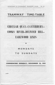
... Alterations on separate pieces of paper in the book - 5 pages. 120.1 - Tramway timetable for Circular Quay - Canterbury - Cooks Rivers - Dulwich Hill - Earlwood lines, 1953. 120.2 - Altered journey for route, Circular Quay - Cooks River line - 1954 120.3 - Altered journey - Dulwich Hill, Glebe Point, Balmain, Lilyfield and Darling St. wharf - Canterbury lines - 1954. 120.4 - Altered journey (on trail) Circular Quay and Darling St. wharf and Canterbury lines - 1954. 120.5 - Additional and altered journeys - Circular Quay and Darling St. wharf lines - 1954 120.6 - Tram time table for Circular Quay - North Bondi line (via Bellevue Hill) including running times, sections and fares - July 26 1954....Alterations on separate pieces of paper in the book - 5 pages. 120.1 - Tramway timetable for Circular Quay - Canterbury - Cooks Rivers - Dulwich Hill - Earlwood lines, 1953. 120.2 - Altered journey for route, Circular Quay - Cooks River line - 1954 120.3 - Altered journey - Dulwich Hill, Glebe Point, Balmain, Lilyfield and Darling St. wharf - Canterbury lines - 1954. 120.4 - Altered journey (on trail) Circular Quay and Darling St. wharf and Canterbury lines - 1954. 120.5 - Additional and altered journeys - Circular Quay and Darling St. wharf lines - 1954 120.6 - Tram time table for Circular Quay - North Bondi line (via Bellevue Hill) including running times, sections and fares - July 26 1954. ...Paper - black and white. Alterations on separate pieces of paper in the book - 5 pages. 120.1 - Tramway timetable for Circular Quay - Canterbury - Cooks Rivers - Dulwich Hill - Earlwood lines, 1953. 120.2 - Altered journey for route, Circular Quay - Cooks River line - 1954 120.3 - Altered journey - Dulwich Hill, Glebe Point, Balmain, Lilyfield and Darling St. wharf - Canterbury lines - 1954. 120.4 - Altered journey (on trail) Circular Quay and Darling St. wharf and Canterbury lines - 1954. 120.5 - Additional and altered journeys - Circular Quay and Darling St. wharf lines - 1954 120.6 - Tram time table for Circular Quay - North Bondi line (via Bellevue Hill) including running times, sections and fares - July 26 1954.sydney, timetables -
 Bendigo Military Museum
Map - RASvy " Map Makers Exhibition 2025 "- Map display, RAN Hydrographic Office, 1972 - 1992
... The shortest distance between two points on the earth's surface is called a "Great Circle Route" which is a route on a circular path on the surface of the earth where the centre of that circle is also the centre of the earth. ...The shortest distance between two points on the earth's surface is called a "Great Circle Route" which is a route on a circular path on the surface of the earth where the centre of that circle is also the centre of the earth. ...All of these Charts / Maps were used for the RSL Museum display " The Mapmakers " ( of RASvy. ) 10 Jun - 10 Aug 2025. .1 Catalogue of Tactical Pilotage Charts, 1:500 000 Scale. Digital Data Base available as at 30Jun 92. This catalogue page shows the extent of the Australian area of responsibility for aeronautical charting. .2 RAAF PLOTTING CHART. NP 22-2 (Navigational Plotting) Tasmania. MERCATOR PROJECTION. This series of charts were used for the training of RAAF Navigators. These charts were produced and printed at the Army Survey Regiment, Bendigo. .3 RAAF PLOTTING CHART AUSTRALIA - SOUTHEAST. NP 27 is Based on LAMBERT CONFORMAL CONIC PROJECTION. This series of charts was used by RAAF Navigators for the planning of RAAF flights. These charts were produced and printed at the Army Survey Regiment, Bendigo. .4 RAAF LONG RANGE PLOTTING CHART. NP 43-4 AUSTRALIA WESTERN. MERCATOR PROJECTION. This series of maps were used for the planning of RAAF flights. Of Particular note these charts were used to plot "Rhumb Lines or loxodromes" where a course crosses all Meridians (Lines of latitude and longitude) at the same angle. On Mercator projection charts Rhumb lines are conveniently shown as straight lines and are also lines of constant compass bearing. Rhumb lines are usually longer than the shortest distance between two points. The shortest distance between two points on the earth's surface is called a "Great Circle Route" which is a route on a circular path on the surface of the earth where the centre of that circle is also the centre of the earth. Great Circle Routes on a Mercator Projection are however curves and harder to plot. These charts were produced and printed at the Army Survey Regiment, Bendigo. .5 RAAF LONG RANGE PLOTTING CHART. NP 43-7 SOLOMON ISLANDS. MERCATOR PROJECTION. Used for the planning of RAAF flights. .6 RAAF AIR STAFF PLANNING CHART NS 137-1 DARWIN NORTH WEST. AZIMUTHAL EQUIDISTANT PROJECTION. This series of charts were used for planning by the staff. The whole chart was produced by joining the four quadrant maps together. The charts are based on a single point of tangency (in this case Darwin) and shows radius (distance) in nautical miles to and from that point. A series of charts were produced centred on each of the major airfields in Northern Australia. These charts were produced and printed at the Army Survey Regiment, Bendigo. .7 RAAF AIR STAFF PLANNING CHART NS 137-2 DARWIN NORTH EAST. AZIMUTHAL EQUIDISTANT PROJECTION. Used for the planning by the staff. The charts are based on a point of tangency and show radius in nautical miles. .8 RAAF AIR STAFF PLANNING CHART NS 137-4 DARWIN SOUTH WEST. AZIMUTHAL EQUIDISTANT PROJECTION. Used for the planning by the staff. The charts are based on a point of tangency and show radius in nautical miles. .9 RAAF AIR STAFF PLANNING CHART NS 137-3 DARWIN SOUTH EAST. AZIMUTHAL EQUIDISTANT PROJECTION. Used for the planning by the staff. The charts are based on a point of tangency and show radius in nautical miles. .10 TACTICAL PILOTAGE CHART. TPC R-13B. LAMBERT CONFORMAL PROJECTION. Used by pilots for flight planning and could be used in flight if necessary for visual navigation using major ground features shown on the chart. These charts also contained aeronautical information such as airfields, radio navigation beacons and obstructions. Contours and height information was shown in feet to be compatible with aircraft altimeters. Each graticule square also contained a Maximum Safe Elevation Figure (MEF) also in feet. Coverage of this series over Australia's area of interest were produced and printed at the Army Survey Regiment, Bendigo. .11 HYDROGRAPHIC CHART. AUS 158. PORT PHILLIP SOUTH and WEST CHANNELS. PROJECTION TRANSVERSE MERCATOR. Used by all people needing to navigate a vessel. Hydrographic charts were printed at the Army Survey Regiment, Bendigo. .12 HYDROGRAPHIC CHART. AUS 157. GEELONG HARBOUR and APPROACHES. PROJECTION TRANSVERSE MERCATOR. Used by all people needing to navigate a vessel. .13 EN ROUTE CHART. AUSTRALIA ERC HIGH. H1 and H2. LAMBERT CONFORMAL CONIC PROJECTION. This series of charts were regularly produced by the RAAF Aeronautical Information Service (AIS) and contained current aeronautical information for pilots. These charts were printed at the Army Survey Regiment, Bendigo..1 Tactical Pilotage Chart Series Catalogue. Current as at 30 Jun 92. .2 Extract of Navigational Plotting Chart " NP22-2 Tasmania " .3 Extract of Navigational Plotting Chart " NP 27 RAAF PLOTTING CHART AUSTRALIA - SOUTHEAST " .4 Extract of Navigational Plotting Chart " RAAF LONG RANGE PLOTTING CHART NP43-4 AUSTRALIA WESTERN " .5 Extract of Navigational Plotting Chart " RAAF LONG RANGE PLOTTING CHART NP43-7 SOLOMON ISLANDS " .6 Extract of Navigational Series " RAAF AIR STAFF PLANNING CHART NS 137-2 DARWIN NORTH WEST " .7 Extract of Navigational Series " RAAF AIR STAFF PLANNING CHART NS 137-1 DARWIN NORTH EAST " .8 Extract of Navigational Series " RAAF AIR STAFF PLANNING CHART NS 137-4 DARWIN SOUTH WEST " .9 Extract of Navigational Series " RAAF AIR STAFF PLANNING CHART NS 137-3 DARWIN SOUTH EAST " .10 Extract of Tactical Pilotage Chart " TPC R-13B " .11 Extract of Hydrographic Chart " PORT PHILLIP SOUTH and WEST CHANNELS " .12 Extract of Hydrographic Chart " GEELONG HARBOUR and APPROACHES " .13 Extract of En Route Chart " AUSTRALIA ERC HIGH " " H1 and H2 " royal australian survey corps, rasvy, fortuna, detachment - army survey regiment, army svy regt, asr -
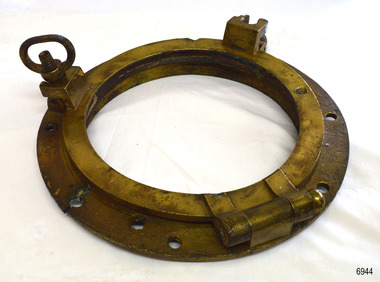 Flagstaff Hill Maritime Museum and Village
Functional object - Porthole Frame, Russell & Co, Ca. 1886
... Routes. She was one of the first vessels to have fore and aft lifting bridges. The vessel is an example of an International Cargo Ship's remains and represents aspects of Victoria’s shipping industry. Flagstaff Hill Warrnambool Maritime Village Maritime Museum Shipwreck coast Great Ocean Road Falls of Halladale shippwreck shipwreck artefact porthole pprthole frame ship's window ship construction shipwreck Peterborough 1908 shipwreck Peterborough shipwreck Russell & Co. Greenock Wright Breakenridge & Co. Glasgow Clipper Ship Porthole frame; cast brass circular ...This restored porthole frame was recovered from the wreck of the Falls of Halladale at Peterborough Victoria. The Falls of Halladale- The ship was an iron-hulled, four-masted barque, used as a bulk carrier of general cargo. She left New York in August 1908 bound for Melbourne and Sydney. In her hold was general cargo consisting of roofing tiles, barbed wire, stoves, oil, benzene, and many other manufactured items. After three months at sea and close to her destination, a navigational error caused the Falls of Halladale to be wrecked on a reef off the Peterborough headland on the 15th of November, 1908. The captain and 29 crew members survived, but her cargo was largely lost, despite two salvage attempts in 1908-09 and 1910. The Court of Marine Inquiry in Melbourne ruled that the foundering of the ship was entirely due to Captain David Wood Thomson's navigational error, not too technical failure of the Clyde-built ship. The Falls of Halladale was built in1886 by Russell & Co., at Greenock shipyards on the River Clyde, Scotland for Wright, Breakenridge & Co of Glasgow. She was one of several designs of the Falls Line of ships named after waterfalls in Scotland. The company was founded between 1870- 1873 as a partnership between Joseph Russell, Anderson Rodger, and William Todd Lithgow. During 1882-92 Russell & Co. standardised designs sped up their building process so much that they could build 271 ships during that time. The Falls of Halladale had a sturdy construction built to carry maximum cargo and was able to maintain full sail in heavy gales, one of the last of the 'windjammers' that sailed the Trade Route. She and her sister ship, the Falls of Garry, were the first ships in the world to include fore and aft lifting bridges. Previously, heavily loaded vessels could have heavy seas break along the full length of the deck, causing serious injury or even death to those on deck. The new, raised catwalk-type decking allowed the crew to move above the deck in stormy conditions. This artefact is important as it is an example of the materials and design of late-19th century ship’s rigging equipment. The object is also significant for its association with the historic sailing ship Falls of Halladale, wrecked in local waters in the early 20th century. The clipper ship Falls of Halladale shipwreck is of historical significance and is listed on the Victorian Heritage Register, No. S255. She was one of the last ships to sail the Trade Routes. She was one of the first vessels to have fore and aft lifting bridges. The vessel is an example of an International Cargo Ship's remains and represents aspects of Victoria’s shipping industry. Porthole frame; cast brass circular frame with several fixing holes, and hinged frame for holding the glass window. The frame has two screw dogs and a solid hinge. The porthole frame has been recondition and the layer of concretion has been removed. The porthole frame was recovered from the wrecked FALLS OF HALLADALE.flagstaff hill, warrnambool, maritime village, maritime museum, shipwreck coast, great ocean road, falls of halladale, shippwreck, shipwreck artefact, porthole, pprthole frame, ship's window, ship construction, shipwreck, peterborough, 1908 shipwreck, peterborough shipwreck, russell & co., greenock, wright breakenridge & co. glasgow, clipper ship -
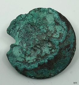 Flagstaff Hill Maritime Museum and Village
Clothing - Button, c. 1845
... route to the Cape Otway area. While doing so he became familiar with the Warrnambool area and the need to establish a new settlement as Warrnambool. Flagstaff Hill Maritime Museum & Village Shipwreck coast Great Ocean Road button King Island Shipwreck Maritime disaster Cape Otway Cataraqui Unable to decipher. Metal button, vertical shank on back. Button experiencing corrosion and one edge has been eaten away. Inscription and two circular ...THE CATARAQUI The Cataraqui was built in 1840 in Quebec, Canada, and wrecked on 4th August, 1845 off the west coast of King Island, Australia. The lives of 400 people on the emigrant ship were lost. Many of them were on government assisted passages from Britain and Ireland. Only nine people, one passenger and eight crew, survived the shipwreck. A man who lived on the island, sheltered them and five weeks later the group was rescued by the ship Midge, which took them to Melbourne. It was the largest civilian maritime disaster.The button is significant as an example of a 19th century clothing accessory. The button is also significant for its association with the 1840 Canadian built ship, Cataraqui. The Cataraqui is significant in maritime history as Australia's largest civilian maritime disaster. The wreck also has a connection to the establishment of the Cape Otway lighthouse and to Warrnambool’s history as Superintendent Charles LaTrobe came to the Warrnambool district several times in an effort to find the best route to the Cape Otway area. While doing so he became familiar with the Warrnambool area and the need to establish a new settlement as Warrnambool.Metal button, vertical shank on back. Button experiencing corrosion and one edge has been eaten away. Inscription and two circular markings on shank side of button. Salvaged from the wreck of the Cataraqui.Unable to decipher.flagstaff hill maritime museum & village, shipwreck coast, great ocean road, button, king island, shipwreck, maritime disaster, cape otway, cataraqui -
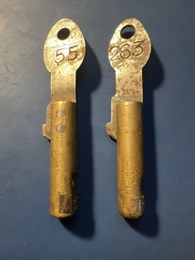 Ballarat Tramway Museum
Functional object - MMTB Cincinnati "bundy" clock keys, Cincinnati Time Recorder Co. of Ohio, 1930s
... routes the driver was responsible for the key and recording the time. The key number represented the crew's shift number. For a while towards the end of their use on the trams they were the Run number. This change led to many lost keys! See item 9568 for an example of the time recording clock itself. Demonstrates a Cincinnati "Bundy" time recording clock key. Tramcars tramways Bundy Clock Cincinnati time recorder clocks Steel section stamped "tramways" and "55" and "263" Key - or Bundy Clock key made for a Cincinnati Time Recording Clock comprising a circular ...Item used to operate and record the time in the Cincinnati Time Recording clock. This type of clock was used by the MMTB in the 1930s. The key would be issued by the depot staff to crews for use in the clock to record times so that they could be matched up against the timetable to see whether tram or bus services were running on time. Understood that this style of key was last used on the Port Melbourne bus route. The Museum has one of these clocks at its depot which was obtained from The Met in? The second photo shows the key in position before turning the handle around it. By the 1960's (or earlier) they were only used on the M&MTB bus routes. All the tram routes had M&MTB copies with a very different style of key. Only used on two man bus routes and the conductor held the key due to the half-cab bus design. On the tram routes the driver was responsible for the key and recording the time. The key number represented the crew's shift number. For a while towards the end of their use on the trams they were the Run number. This change led to many lost keys! See item 9568 for an example of the time recording clock itself.Demonstrates a Cincinnati "Bundy" time recording clock key.Key - or Bundy Clock key made for a Cincinnati Time Recording Clock comprising a circular brass section with a key number section secured by a screw at one end and a flat steel strip inserted into the brass section, with a hole at one end that could be placed on a hook. The steel strip is riveted into the brass round section. Two keys held.Steel section stamped "tramways" and "55" and "263"tramcars, tramways, bundy clock, cincinnati, time recorder clocks -
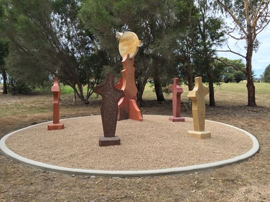 Federation University Art Collection
Sculpture, 'Mungo Moon' by Don Barrett, 2015
... When the loop is completed, residents and visitors will have an approximately 5km circular walking path which links up the Churchill town centre, Federation University Australia and Mathison Park. There are already art features along this route, including primary schools’ Bug Blitz totems near the Kurnai College school crossing, native vegetation and history panels near the Hare Homestead in Mathison Park, and outdoor sculptures in the pine trees near the Federation University Switchback Gallery. ...When the loop is completed, residents and visitors will have an approximately 5km circular walking path which links up the Churchill town centre, Federation University Australia and Mathison Park. There are already art features along this route, including primary schools’ Bug Blitz totems near the Kurnai College school crossing, native vegetation and history panels near the Hare Homestead in Mathison Park, and outdoor sculptures in the pine trees near the Federation University Switchback Gallery. churchill art and culture pathway barrett don barrett gippsland campus federation university churchill sculpture A large sculpture in five pieces set in an external location. ...'Mungo Moon' by Don Barrett is the first sculpture erected on the Churchill Art and Culture Pathway. It was officially unveiled by Professor David Battersby on 15 April 2015 From Churchill & District News 16 October 2014 The Churchill Art and Culture Walking Pathway will have its official public opening on Saturday October 18, with a walk finishing at Federation University Australia’s Switchback Gallery at the Federation University Gippsland Campus. ... An important link on the newly developed pathway was recently completed with a path south of the FedUni Student West Residences. The path now allows walkers to turn off the Eel Hole Creek path before reaching Glendonald Estate and to follow a picturesque, tree lined walkway to join up with the footpath on the Eastern side of Northways Road. From there the footpath joins into Federation University’s network of walking paths that proceeds past the Switchback Art Gallery, down through the pine plantation and along Lake Kretlow and the Churchill Golf Course. Project Manager Mike Answerth, said the opening of the West Residences section of the path means there is now only one short link to complete. “We’re now very close to realising the project’s objective to join up all these walking paths to provide a continuous pathway that encompasses town, campus and parkland. The next stage of the project will be the completion of Latrobe City’s East West Link and the enhancement of the walking path with artistic and cultural features.” said Mr. Answerth. Head of Federation University Australia Gippsland Campus, Dr Harry Ballis, said the project had been made possible through the contributions of the five former Gippsland Education Precinct (GEP) partners. “The Art and Culture Pathway represents another important step in joining the Churchill township and the university campus as a physical and social entity,” Dr Ballis said. “This was an initiative of the GEP and it is pleasing to see it coming to fruition.” The path now reaches as far as the golf driving range but plans are already under way to connect with the Mathison Park board walk and pathway, which surrounds Lake Hyland in Churchill. When the loop is completed, residents and visitors will have an approximately 5km circular walking path which links up the Churchill town centre, Federation University Australia and Mathison Park. There are already art features along this route, including primary schools’ Bug Blitz totems near the Kurnai College school crossing, native vegetation and history panels near the Hare Homestead in Mathison Park, and outdoor sculptures in the pine trees near the Federation University Switchback Gallery. contemporaryA large sculpture in five pieces set in an external location. It is part of the Churchill Art and Culture Walking Pathway. Don Barrett’s work is mainly in concrete with added coloured oxides to portray the feeling of the Australian landscape. Barrett focuses on concepts of Australia’s short history and indigenous history. churchill art and culture pathway, barrett, don barrett, gippsland campus, federation university, churchill, sculpture -
 Melbourne Tram Museum
Photograph - Black & White Photograph/s, early 1950's?
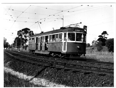
... route 56, on the open ballasted track just before passing under the railway line at the Zoo gardens area. Shows the open doors with the bars down. Photo of the tram slightly out of focus. Taken early 1950's by an unknown photographer. In the overhead shows a sign black cross in a circular...route 56, on the open ballasted track just before passing under the railway line at the Zoo gardens area. Shows the open doors with the bars down. Photo of the tram slightly out of focus. Taken early 1950's by an unknown photographer. In the overhead shows a sign black cross in a circular ...Black and white photograph of W5 No. 779 inbound to the City and Domain Road on route 56, on the open ballasted track just before passing under the railway line at the Zoo gardens area. Shows the open doors with the bars down. Photo of the tram slightly out of focus. Taken early 1950's by an unknown photographer. In the overhead shows a sign black cross in a circular disc and behind the tram a incandescent light suspended in the middle of the overhead. The photo shows the construction of the track at this location, dog spiked sleepers, the rail supports for the inner check rail. In the background behind the tram is the lever for the points of the crossover.On the rear in red ink "Melbourne tram shows use of Off-street tracks in an outer suburb"trams, tramways, zoo tram, reserved track, track construction, w5 class -
 Melbourne Tram Museum
Flag, Evan Evans Flags, "Poppy Appeal", c1990
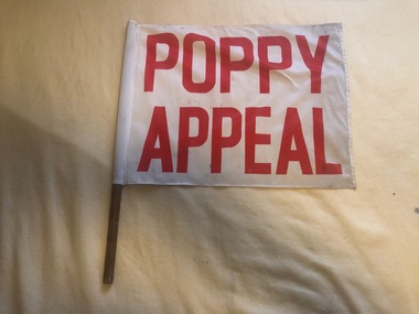
... route number box of W class tramscars Demonstrates a flag for tramcars to assist in raising funds for veterans and their Families by the RSL. Trams tramways Flags Melbourne Anzac RSL Flag advertising the Poppy Appeal, red print on white background, mounted on wooden dowel for use on Melbourne tramcars. Flag made from nylon or a similar synthetic, sewn into a white nylon circular ...Flag used to advertise the November 11 Poppy Appeal held by the RSL to raise funds for veterans and their families. Placed in a flag holder on one side of the route number box of W class tramscarsDemonstrates a flag for tramcars to assist in raising funds for veterans and their Families by the RSL.Flag advertising the Poppy Appeal, red print on white background, mounted on wooden dowel for use on Melbourne tramcars. Flag made from nylon or a similar synthetic, sewn into a white nylon circular section and then slipped over the dowel and stapled into position. Label sewn into flag with Evan Evans name, address and phone number - 7 digits.trams, tramways, flags, melbourne, anzac, rsl -
 Melbourne Tram Museum
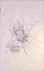
Drawing, Melbourne & Metropolitan Tramways Board (MMTB), "MMTB Underground Tram Routes", c1962
... Circular tunnel 16ft internal dia with Australian Railways Ultimate Maximum Rolling Stock Outline, 1963. Shows profiles of a Harris Blue Train, Class M, and a class W4 tram. 7 - Figure 7 - as for figure 6 but with a MMTB rear entrance Leyland Double deck bus body shown. 8 - Figure 8 - Underground tram routes - proposed basic arrangement at street intersection, typical cross sections. ...Circular tunnel 16ft internal dia with Australian Railways Ultimate Maximum Rolling Stock Outline, 1963. Shows profiles of a Harris Blue Train, Class M, and a class W4 tram. 7 - Figure 7 - as for figure 6 but with a MMTB rear entrance Leyland Double deck bus body shown. 8 - Figure 8 - Underground tram routes - proposed basic arrangement at street intersection, typical cross sections. ...Part of the development of the project for an underground tram line in Swanston St.Yields information about the MMTB proposal for an underground tramway in Swanston St. Set of eight drawings from a set of 8 foolscap sheets showing proposals for undergrounding tramways in the central part of the city - c1970. Models and other drawings have featured in the MMTB Annual Reports of the time. 1 - Fig 1 - 30 Minute travel contours from CBD. 2 - Fig 2 - 60 Minute travel contours from CBD. 3 - Fig 3 - Swanston St underground tramway proposal 4 - Fig 4 - Swanston St underground tramway proposal - detail 5 - Fig 5 - Rapid Transit systems 6 - Figure 6 - Circular tunnel 16ft internal dia with Australian Railways Ultimate Maximum Rolling Stock Outline, 1963. Shows profiles of a Harris Blue Train, Class M, and a class W4 tram. 7 - Figure 7 - as for figure 6 but with a MMTB rear entrance Leyland Double deck bus body shown. 8 - Figure 8 - Underground tram routes - proposed basic arrangement at street intersection, typical cross sections. See also Reg Item 3069 and 409 for other references.trams, tramways, mmtb, melbourne, swanston st, bourke st, underground tramways, w4 class -
 Melbourne Tram Museum
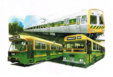
Poster, The Met, Comeng Train (404M), A class (238) and MAN Bus (117) - new The Met livery, c1984
... circular logo. Train showing a destination of Werribee, tram - Mont Albert route 42 and the Bus, Warrandyte, route 265....circular logo. Train showing a destination of Werribee, tram - Mont Albert route 42 and the Bus, Warrandyte, route 265. ...Poster - printed on heavy card paper, featuring a Comeng Train (404M), A class (238) and MAN Bus (117) all in the then new The Met livery featuring the circular logo. Train showing a destination of Werribee, tram - Mont Albert route 42 and the Bus, Warrandyte, route 265.trams, tramways, posters, the met, comeng, a class, buses, mont albert, tram 238 -
 Melbourne Tram Museum
Photograph - Set of 3 Colour Negatives, Phil A'Vard, 10/02/1962 12:00:00 AM
... Routes at Footscray. .1 - W4 670 passing under the King St bridge in Queensbridge St, South Melbourne. Has an AETA tour Auxiliary board is showing Special. .2 - ditto, followed by W3 655 crossing the Maribyrnong Road Bridge. .3 - ditto - turning on the reserved track alongside Wests Road. Taken on Perutz film - see 3997 for the AETA Tour circular...Routes at Footscray. .1 - W4 670 passing under the King St bridge in Queensbridge St, South Melbourne. Has an AETA tour Auxiliary board is showing Special. .2 - ditto, followed by W3 655 crossing the Maribyrnong Road Bridge. .3 - ditto - turning on the reserved track alongside Wests Road. Taken on Perutz film - see 3997 for the AETA Tour circular ...Set of 3 photographs taken on the AETA tour Sat. 10/2/1962 - Closure of the Local Tram Routes at Footscray. .1 - W4 670 passing under the King St bridge in Queensbridge St, South Melbourne. Has an AETA tour Auxiliary board is showing Special. .2 - ditto, followed by W3 655 crossing the Maribyrnong Road Bridge. .3 - ditto - turning on the reserved track alongside Wests Road. Taken on Perutz film - see 3997 for the AETA Tour circular. and see 5998 for other photographs.trams, tramways, footscray, aeta, maribyrnong river bridge, maribyrnong rd, wests rd, queensbridge st, w4 class, w3 class, tram 670 -
 Melbourne Tram Museum
Photograph - Set of two Colour Prints, Phil A'Vard, 10/02/1962 12:00:00 AM
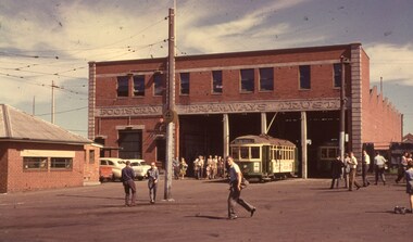
... Set of 2 photographs taken on the AETA tour Sat. 10/2/1962 - Closure of the Local Tram Routes at Footscray. .1 - Scene at Footscray Tram Depot with the name "Footscray Tramways Trust" Prominent on the building with tram X1 467 sitting on the depot fan with many of the travellers in the view on the hot day. .2 - as above. Taken on Perutz film - see 3997 for the AETA Tour circular...Melbourne Tram Museum 8 Wallen Road Hawthorn melbourne Trams tramways Footscray AETA Footscray Depot FTT X1 class tram 467 Set of 2 photographs taken on the AETA tour Sat. 10/2/1962 - Closure of the Local Tram Routes at Footscray. .1 - Scene at Footscray Tram Depot with the name "Footscray Tramways Trust" Prominent on the building with tram X1 467 sitting on the depot fan with many of the travellers in the view on the hot day. .2 - as above. Taken on Perutz film - see 3997 for the AETA Tour circular ...Set of 2 photographs taken on the AETA tour Sat. 10/2/1962 - Closure of the Local Tram Routes at Footscray. .1 - Scene at Footscray Tram Depot with the name "Footscray Tramways Trust" Prominent on the building with tram X1 467 sitting on the depot fan with many of the travellers in the view on the hot day. .2 - as above. Taken on Perutz film - see 3997 for the AETA Tour circular.trams, tramways, footscray, aeta, footscray depot, ftt, x1 class, tram 467 -
 Melbourne Tram Museum
Photograph - Set of 3 Colour Negatives, Phil A'Vard, 10/02/1962 12:00:00 AM
... Set of 3 photographs taken on the AETA tour Sat. 10/2/1962 - Closure of the Local Tram Routes at Footscray. .1 - X2 677 inbound at the corner of Gannon and Charles Sts Footscray with a BP service station in the distance. .2 - X2 677 and two X1 class cars at the Williamstown Road terminus in Somerville Road. .3 - ditto, with X1 467 at the rear of the 3 trams. Has the tram sign on the left hand side of the photograph, with a Craven A and Nugget boot polish signs in the view. Taken on Perutz film - see 3997 for the AETA Tour circular...Melbourne Tram Museum 8 Wallen Road Hawthorn melbourne Trams tramways Footscray AETA Williamstown Rd Charles St Gannon St X1 class X2 class tram 677 tram 467 Set of 3 photographs taken on the AETA tour Sat. 10/2/1962 - Closure of the Local Tram Routes at Footscray. .1 - X2 677 inbound at the corner of Gannon and Charles Sts Footscray with a BP service station in the distance. .2 - X2 677 and two X1 class cars at the Williamstown Road terminus in Somerville Road. .3 - ditto, with X1 467 at the rear of the 3 trams. Has the tram sign on the left hand side of the photograph, with a Craven A and Nugget boot polish signs in the view. Taken on Perutz film - see 3997 for the AETA Tour circular ...Set of 3 photographs taken on the AETA tour Sat. 10/2/1962 - Closure of the Local Tram Routes at Footscray. .1 - X2 677 inbound at the corner of Gannon and Charles Sts Footscray with a BP service station in the distance. .2 - X2 677 and two X1 class cars at the Williamstown Road terminus in Somerville Road. .3 - ditto, with X1 467 at the rear of the 3 trams. Has the tram sign on the left hand side of the photograph, with a Craven A and Nugget boot polish signs in the view. Taken on Perutz film - see 3997 for the AETA Tour circular.trams, tramways, footscray, aeta, williamstown rd, charles st, gannon st, x1 class, x2 class, tram 677, tram 467 -
 Melbourne Tram Museum
Photograph - Set of 3 Colour Negatives, Phil A'Vard, 10/02/1962 12:00:00 AM
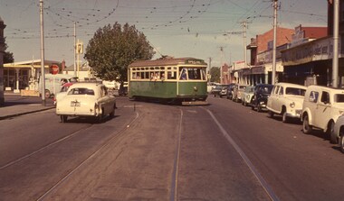
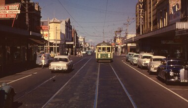
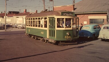
... Routes at Footscray. .1 - X1 in Hopkins Street Footscray, has the Duci Bros electrical store?, and the Hoyts Trocadero Theatre in the background. .2 - X1 468 and another X1 in Barkly Street with the Footscray Drill Hall in the background .3 - X2 677 and two X1 cars at the corner of Barkly Street and Summerhill Road, West Footscray. Taken on Perutz film - see 3997 for the AETA Tour circular...Routes at Footscray. .1 - X1 in Hopkins Street Footscray, has the Duci Bros electrical store?, and the Hoyts Trocadero Theatre in the background. .2 - X1 468 and another X1 in Barkly Street with the Footscray Drill Hall in the background .3 - X2 677 and two X1 cars at the corner of Barkly Street and Summerhill Road, West Footscray. Taken on Perutz film - see 3997 for the AETA Tour circular ...Set of 3 photographs taken on the AETA Sat. 10/2/1962 - Closure of the Local Tram Routes at Footscray. .1 - X1 in Hopkins Street Footscray, has the Duci Bros electrical store?, and the Hoyts Trocadero Theatre in the background. .2 - X1 468 and another X1 in Barkly Street with the Footscray Drill Hall in the background .3 - X2 677 and two X1 cars at the corner of Barkly Street and Summerhill Road, West Footscray. Taken on Perutz film - see 3997 for the AETA Tour circular.trams, tramways, footscray, aeta, tours, barkly st, x1 class, x2 class, tram 468, tram 677, tram 467, hopkins st -
 Melbourne Tram Museum
Photograph - Set of two Colour Prints, Phil A'Vard, 10/02/1962 12:00:00 AM
... Set of 2 photographs taken on the AETA Sat. 10/2/1962 - Closure of the Local Tram Routes at Footscray. .1 - X1 468 returning to the depot after the tour. .2 - X2 677 ditto. Taken on Perutz film - see 3997 for the AETA Tour circular....Melbourne Tram Museum 8 Wallen Road Hawthorn melbourne Trams tramways Footscray AETA Tours Footscray Depot X1 class X2 class tram 468 tram 677 Set of 2 photographs taken on the AETA Sat. 10/2/1962 - Closure of the Local Tram Routes at Footscray. .1 - X1 468 returning to the depot after the tour. .2 - X2 677 ditto. Taken on Perutz film - see 3997 for the AETA Tour circular. ...Set of 2 photographs taken on the AETA Sat. 10/2/1962 - Closure of the Local Tram Routes at Footscray. .1 - X1 468 returning to the depot after the tour. .2 - X2 677 ditto. Taken on Perutz film - see 3997 for the AETA Tour circular.trams, tramways, footscray, aeta, tours, footscray depot, x1 class, x2 class, tram 468, tram 677 -
Melbourne Tram Museum
Administrative record - Circular, Department of Defence, Melbourne and Metropolitan Tramways Board (MMTB), Defence Week, Jan/Feb 1934
... route of march through the city. 2. - Memo from Assistant Manager to Dist. Traffic Supts NS & SS, dated 5 Feb 1934, providing details of Defence Week, with plan of march. 3. - 10 pages of memos to senior inspectors for shunting arrangements. 4. - 3rd Military District Circular No 4/1934 - describing the march. 5 pages 5. - Programme for week - 2 page program of Defence Week activities...route of march through the city. 2. - Memo from Assistant Manager to Dist. Traffic Supts NS & SS, dated 5 Feb 1934, providing details of Defence Week, with plan of march. 3. - 10 pages of memos to senior inspectors for shunting arrangements. 4. - 3rd Military District Circular No 4/1934 - describing the march. 5 pages 5. - Programme for week - 2 page program of Defence Week activities Defence Week Administrative record Circular Department of Defence, Melbourne and Metropolitan Tramways Board (MMTB) JH Crombie, Simpson, Briggs, Hickingbotham, Mr Eakins, Miller ...Defence Week - Monday 12/2/34 to Saturday 17/2/34 1. - Newspaper clipping - Arrangements for March - provides details and route of march through the city. 2. - Memo from Assistant Manager to Dist. Traffic Supts NS & SS, dated 5 Feb 1934, providing details of Defence Week, with plan of march. 3. - 10 pages of memos to senior inspectors for shunting arrangements. 4. - 3rd Military District Circular No 4/1934 - describing the march. 5 pages 5. - Programme for week - 2 page program of Defence Week activitiestrams, tramways, instructions, events -
 Melbourne Tram Museum
Photograph - Car Wash Road, Sutcliffe Pty Ltd, 1946
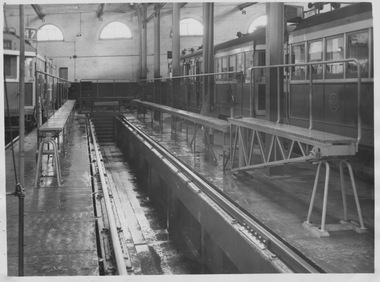
... Route 47...semi-circular windows...Three W2 class trams are partially shown on adjacent roads, one displaying route number 47 (City to Kew Depot). Several semi-circular windows are shown high on the rear wall. ...Three W2 class trams are partially shown on adjacent roads, one displaying route number 47 (City to Kew Depot). Several semi-circular windows are shown high on the rear wall. ...Photograph of vacant tramcar wash road facility, presumably at Kew Depot. Three W2 class trams are partially shown on adjacent roads, one displaying route number 47 (City to Kew Depot). Several semi-circular windows are shown high on the rear wall. Along both sides of the vacant road are narrow 40 cm wide platforms approx 60 cms above the car shed floor with safety rails attached. An open pit sits between the two platforms. A water hose pipe appears in the foreground and all surfaces appear wet. With a tram was positioned between these platforms, part of the platform could be swung across the front of the tram to facilitate its washing. See ute 8889 for a 1946 photo of the road in use with tram W2 284.Yields information about maintenance facilities inside tram shed. Black and white photograph with ink stamp on rearInk stamp reads "43 51 Sutcliffe Pty Ltd, Commercial Photographers, 94 Elizabeth Street, Melbourne, Cent. 1500" wash road, w2 class, kew depot, route 47, semi-circular windows -
 Melbourne Tram Museum
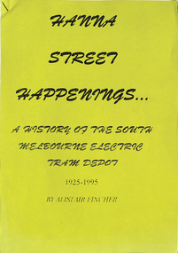
Document - Report, Alistair Fincher, "Hanna Street Happenings - a history of the South Melbourne Electric Tram Depot - 1925 - 1995", 1995
... Gives a detailed history of the depot, its routes, relationship to the cable tramways, some stories, the Restaurant tram, comment from Chris Jacobson, Inspector Frank Reardon, Jack Gregan, electrocution of Dan White climbing a roof, Kingsway, "the TV programme "Our World", Women of the depot. Includes notes on industrial disputes, tram types, a map showing countries of origins, a WW2 Roll of Honour, and a list of Union delegates. .2 - Illustration of a logo - red circle with a SW6 tram - 70 years - colour photocopy cut into a circular....Gives a detailed history of the depot, its routes, relationship to the cable tramways, some stories, the Restaurant tram, comment from Chris Jacobson, Inspector Frank Reardon, Jack Gregan, electrocution of Dan White climbing a roof, Kingsway, "the TV programme "Our World", Women of the depot. Includes notes on industrial disputes, tram types, a map showing countries of origins, a WW2 Roll of Honour, and a list of Union delegates. .2 - Illustration of a logo - red circle with a SW6 tram - 70 years - colour photocopy cut into a circular. ....1 - Essay or Report - 16 A4 photocopied sheets stapled in the top left hand corner with a green sheet on the front, titled "Hanna Street Happenings - a history of the South Melbourne Electric Tram Depot - 1925 - 1995" written by Alistair Fincher. Gives a detailed history of the depot, its routes, relationship to the cable tramways, some stories, the Restaurant tram, comment from Chris Jacobson, Inspector Frank Reardon, Jack Gregan, electrocution of Dan White climbing a roof, Kingsway, "the TV programme "Our World", Women of the depot. Includes notes on industrial disputes, tram types, a map showing countries of origins, a WW2 Roll of Honour, and a list of Union delegates. .2 - Illustration of a logo - red circle with a SW6 tram - 70 years - colour photocopy cut into a circular.trams, tramways, hanna st, south melbourne depot, stories, kingsway, women drivers, conductors, accidents, tv broadcasts