Showing 409 items matching "city of heidelberg"
-
 Greensborough Historical Society
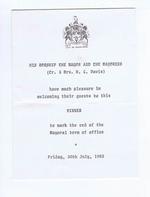
Memorabilia - Invitation and Program, City of Heidelberg, City of Heidelberg Dinner 1982, 30/07/1982
... City of Heidelberg Dinner 1982......city of heidelberg...Invitation and program to City of Heidelberg Mayoral Dinner hosted by Cr. and Mrs. ...Invitation on letter head, black text and blue City of Heidelberg crest. 2. Program cream paper, black text with City of Heidelberg crest....City of Heidelberg...Program cream paper, black text with City of Heidelberg crest. City of Heidelberg Dinner 1982 Memorabilia Invitation and Program City of Heidelberg ...Invitation and program to City of Heidelberg Mayoral Dinner hosted by Cr. and Mrs. H.C. Davis, 39th July, 1982.Bruce Morgan was the first Shire Secretary (1964-1983) of the Shire of Diamond Valley. This collection was compiled by his wife, Mavis Morgan, detailing the events they attended in their official capacity.1. Invitation on letter head, black text and blue City of Heidelberg crest. 2. Program cream paper, black text with City of Heidelberg crest.bruce morgan, mavis morgan, city of heidelberg -
 Greensborough Historical Society
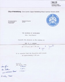
Memorabilia - Invitation, City of Heidelberg, City of Heidelberg Mayoress Reception 1981, 1981
... City of Heidelberg Mayoress Reception 1981......city of heidelberg...Invitation to City of Heidelberg Reception hosted by he Mayoress of Heidelberg Mrs Enid Davis on 19th April, 1981....Invitation on City of Heidelberg letterhead with blue crest, cream paper with black text....City of Heidelberg...City of Heidelberg Mayoress Reception 1981 Memorabilia Invitation City of Heidelberg ...Invitation to City of Heidelberg Reception hosted by he Mayoress of Heidelberg Mrs Enid Davis on 19th April, 1981.Bruce Morgan was the first Shire Secretary (1964-1983) of the Shire of Diamond Valley. This collection was compiled by his wife, Mavis Morgan, detailing the events they attended in their official capacityInvitation on City of Heidelberg letterhead with blue crest, cream paper with black text.bruce morgan, mavis morgan, city of heidelberg -
 Greensborough Historical Society
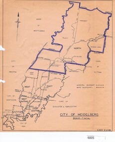
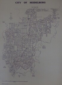
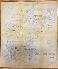
Map, City of Heidelberg, City of Heidelberg, 1962, 02/02/1962
... City of Heidelberg, 1962...city of heidelberg...Map of City of Heidelberg showing boundaries of its six wards; North Ward is highlighted, covering Watsonia, Greensborough, part Bundoora, St Helena, Plenty, Yarrambat and Diamond Creek....City of Heidelberg Scale: 1" to 1 ml. G.M.H. 2.2.62...City of Heidelberg...G.M.H. 2.2.62 Blue print map City of Heidelberg, 1962 Map City of Heidelberg ...Map of City of Heidelberg showing boundaries of its six wards; North Ward is highlighted, covering Watsonia, Greensborough, part Bundoora, St Helena, Plenty, Yarrambat and Diamond Creek.Blue print mapCity of Heidelberg Scale: 1" to 1 ml. G.M.H. 2.2.62city of heidelberg, heidelberg - maps -
 Greensborough Historical Society
Memorabilia - Invitation, City of Whittlesea et al, Shire of Whittlesea Ball Invitation; and, City of Heidelberg Mayoral Charity Ball 1974, 1974
... Shire of Whittlesea Ball Invitation; and, City of Heidelberg Mayoral Charity Ball 1974......city of heidelberg...Invitation to City of Heidelberg Mayoral Charity Ball hosted by Cr. ...Invitation on cream paper, blue text with City of Heidelberg crest...City of Whittlesea...City of Heidelberg...Invitation on cream paper, blue text with City of Heidelberg crest Shire of Whittlesea Ball Invitation; and, City of Heidelberg Mayoral Charity Ball 1974 Memorabilia Invitation City of Whittlesea City of Heidelberg ...1. Invitation to Shire of Whittlesea Ball hosted by Cr T.B. Hussey and Mrs. Hussey on 31st May 1974. 2. Invitation to City of Heidelberg Mayoral Charity Ball hosted by Cr. D. Jean Baker and Mr. Eric Baker on 7th June 1974.Bruce Morgan was the first Shire Secretary (1964-1983) of the Shire of Diamond Valley. This collection was compiled by his wife, Mavis Morgan, detailing the events they attended in their official capacity1. Invitation on cream paper, black text with Shire of Whittlesea crest. 2. Invitation on cream paper, blue text with City of Heidelberg crestbruce morgan, mavis morgan, shire of whittlesea, city of heidelberg -
 Greensborough Historical Society
Maps, City of Heidelberg 1989, 1989_05
... City of Heidelberg 1989...city of heidelberg...Map of City of Heidelberg as at 18/11/1994...City of Heidelberg...Greensborough Historical Society 34A Glenauburn Road Lower Plenty Lower Plenty melbourne Map of City of Heidelberg as at 18/11/1994 city of heidelberg heidelberg Blueprint, Scale 1km: 8 cm City of Heidelberg 1989 Maps City of Heidelberg ...Map of City of Heidelberg as at 18/11/1994Blueprint, Scale 1km: 8 cmcity of heidelberg, heidelberg -
 Greensborough Historical Society
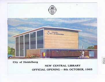
Memorabilia - Brochure, City of Heidelberg. Engineers Dept, City of Heidelberg New Central Library - Official Opening, 8th October 1965, 08/10/1965
... City of Heidelberg New Central Library - Official Opening, 8th October 1965......city of heidelberg...Program for the opening of the City of Heidelberg New Central Library 8th October 1965...City of Heidelberg. Engineers Dept....This collection was compiled by his wife, Mavis Morgan, detailing the events they attended in their official capacity bruce morgan mavis morgan shire of diamond valley city of heidelberg 7 page brochure with black text and floor plans and coloured image on front page City of Heidelberg New Central Library - Official Opening, 8th October 1965 Memorabilia Brochure City of Heidelberg. ...Program for the opening of the City of Heidelberg New Central Library 8th October 1965Bruce Morgan was the first Shire Secretary (1964-1983) of the Shire of Diamond Valley. This collection was compiled by his wife, Mavis Morgan, detailing the events they attended in their official capacity7 page brochure with black text and floor plans and coloured image on front pagebruce morgan, mavis morgan, shire of diamond valley, city of heidelberg -
 Greensborough Historical Society
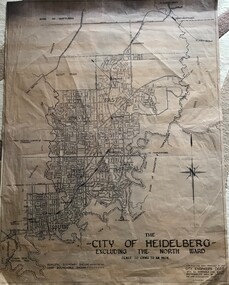
Map, City of Heidelberg, City of Heidelberg, - excluding the North Ward, 1959, 27/05/1959
... City of Heidelberg, - excluding the North Ward, 1959...city of heidelberg...Map of City of Heidelberg showing municipal and ward boundaries; North Ward is excluded from this map....City of Heidelberg...Map of City of Heidelberg showing municipal and ward boundaries; North Ward is excluded from this map. city of heidelberg heidelberg - maps "Scale 20 chns to an inch. ...Map of City of Heidelberg showing municipal and ward boundaries; North Ward is excluded from this map.Blue print map on fabric"Scale 20 chns to an inch. G.M.H. 27.5.59"city of heidelberg, heidelberg - maps -
 Greensborough Historical Society
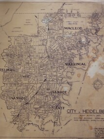
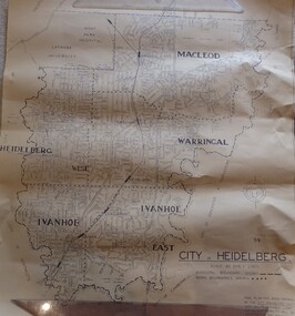
Map, City of Heidelberg: Municipal and Ward boundaries, 1967c
... City of Heidelberg: Municipal and Ward boundaries...city of heidelberg...This map of the City of Heidelberg was issued subsequent to the separation of Heidelberg's North Ward to become the Shire of Diamond Valley...City of Heidelberg...Scale: 20 chs to 1 inch City of Heidelberg: Municipal and Ward boundaries Map City of Heidelberg ...This map of the City of Heidelberg was issued subsequent to the separation of Heidelberg's North Ward to become the Shire of Diamond ValleyBlack on waxed paper. Scale: 20 chs to 1 inchG M Hutchins. 50c.city of heidelberg, heidelberg -
 Greensborough Historical Society
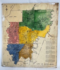
Poster - Map, City of Heidelberg, 1965c
... City of Heidelberg...city of heidelberg...Map of the City of Heidelberg showing municipal boundaries and Wards are coloured. ...City of Heidelberg...Colour map, pasted on card and laminated. City of Heidelberg Poster Map City of Heidelberg ...Map of the City of Heidelberg showing municipal boundaries and Wards are coloured. Scale 20 chains to 1 inch.An example of hard copy plans from the 1960s. Mainly from the Shire of Diamond Valley era (1964-1994).Colour map, pasted on card and laminated.Stamped and handwritten Council permissions, dates and other details. city of heidelberg, heidelberg - maps, local government -
 Greensborough Historical Society
Map, City of Heidelberg. Engineers Dept, City of Heidelberg, 1960s
... City of Heidelberg...city of heidelberg...Map of the City of Heidelberg from the Yarra River in the South to North of Watsonia Military Camp. ...City of Heidelberg. Engineers Dept....City of Heidelberg Map City of Heidelberg. Engineers Dept. ...Map of the City of Heidelberg from the Yarra River in the South to North of Watsonia Military Camp. Shire of Diamond Valley is shown to the north.Map showing municipal and ward boundaries, black text on light brown paper."Scale: 20 CHS = to 1 IN"city of heidelberg -
 Greensborough Historical Society
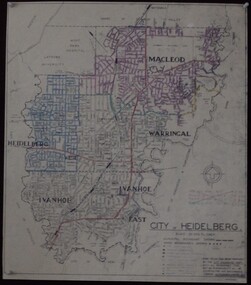
Maps, City of Heidelberg 1974, 1974c
... City of Heidelberg 1974...city of heidelberg...City of Heidelberg showing Municipal and Ward boundaries, prepared by City Engineers Department. ...City of Heidelberg...Scale: 20 chains to 1 inch City of Heidelberg 1974 Maps City of Heidelberg ...City of Heidelberg showing Municipal and Ward boundaries, prepared by City Engineers Department. Made for Council use; copies available for sale to the public.Blueprint, 2 copies, one with some roads hand coloured, showing municipal and ward boundaries. Scale: 20 chains to 1 inchG. M. Hutchins. Authorised charge 50c.city of heidelberg, heidelberg -
 Greensborough Historical Society
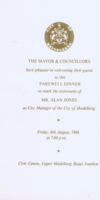
Memorabilia - Menu, City of heidelberg, City of Heidelberg Farewell Dinner to mark the retirement of Alan Jones, 08/08/1986
... City of Heidelberg Farewell Dinner to mark the retirement of Alan Jones......city of heidelberg...Menu for City of Heidelberg's Farewell Dinner to mark the retirement of Mr Alan Jones, City Manager, held on Friday 8th August 1986....City of heidelberg...City of Heidelberg Farewell Dinner to mark the retirement of Alan Jones Memorabilia Menu City of heidelberg ...Menu for City of Heidelberg's Farewell Dinner to mark the retirement of Mr Alan Jones, City Manager, held on Friday 8th August 1986.Bruce Morgan was the first Shire Secretary (1964-1983) of the Shire of Diamond Valley. This collection was compiled by his wife, Mavis Morgan, detailing the events they attended in their official capacityWhite card with gold text and logo.bruce morgan, mavis morgan, city of heidelberg -
 Greensborough Historical Society
Poster - Map, City of Heidelberg, 1984
... City of Heidelberg...city of heidelberg...Numbered grid map of the City of Heidelberg showing municipal boundaries in 1984 . ...City of Heidelberg...Double sided. City of Heidelberg Poster Map City of Heidelberg ...Numbered grid map of the City of Heidelberg showing municipal boundaries in 1984 . Scale 1 inch to 160 feet. Side 2: MMBW Plans Yarra 2000, note Ward boundaries not updated on this plan.An example of hard copy plans from the 1960s. Mainly from the Shire of Diamond Valley era (1964-1994).Map printed on brown paper and laminated. Double sided.city of heidelberg, mmbw -
 Greensborough Historical Society
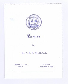
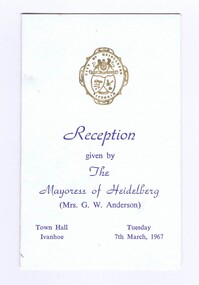
Memorabilia - Programs, City of Preston et al, City of Heidelberg Mayoress Reception Program; and, City of Preston Mayoress Reception Program 1967, 1967
... City of Heidelberg Mayoress Reception Program; and, City of Preston Mayoress Reception Program 1967......city of heidelberg...Program for City of Heidelberg Mayoress Reception hosted by Mrs. ...City of Preston...City of Heidelberg...Program for City of Heidelberg Mayoress Reception hosted by Mrs. ...1. Program for City of Heidelberg Mayoress Reception hosted by Mrs. G.W. Anderson on 7th March, 1966. 2.Program for City of Preston Mayoress Reception hosted by Mrs. K.P. Hardiman on 26th October, 1967.Bruce Morgan was the first Shire Secretary (1964-1983) of the Shire of Diamond Valley. This collection was compiled by his wife, Mavis Morgan, detailing the events they attended in their official capacity1. Off white card with blue text and gold logo. 2. Off white card with red text and logobruce morgan, mavis morgan, shire of diamond valley, city of heidelberg, city of preston -
 Greensborough Historical Society
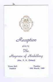
Memorabilia - Reception Cards, Shire of Whittlesea et al, City of Heidelberg Mayoress Reception Programme, Shire of Whittlesea Reception Programme, and, City of Doncaster & Templestowe Mayoress Reception Programme 1969, 1969
... City of Heidelberg Mayoress Reception Programme, Shire of Whittlesea Reception Programme, and, City of Doncaster & Templestowe Mayoress Reception Programme 1969......city of heidelberg...Program for City of Heidelberg Mayoress reception, hosted by Mrs P.H. ......City of Heidelberg...Greensborough Historical Society 34A Glenauburn Road Lower Plenty Lower Plenty melbourne Program for City of Heidelberg Mayoress reception, hosted by Mrs P.H. ...Program for City of Heidelberg Mayoress reception, hosted by Mrs P.H. Cleland on 18th March, 1989; and, Program for Shire of Whittlesea Mayoress reception, hosted by Mrs K.N. Balharrie on 26th March, 1989; and, Program for City of Doncaster & Templestowe Mayoress reception, hosted by Mrs R.A. Hale on 27th March, 1989. Bruce Morgan was the first Shire Secretary (1964-1983) of the Shire of Diamond Valley. This collection was compiled by his wife, Mavis Morgan, detailing the events they attended in their official capacity1. Folded white Card with blue text and gold logo, 2. Folded white card with gold text and logo, 3. Folded white card with black textbruce morgan, mavis morgan, city of heidelberg, city of doncaster and templestowe, shire of whittlesea -
 Greensborough Historical Society
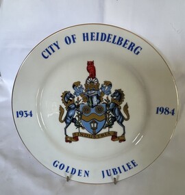
Decorative object - Commemorative Plate, Westminster, City of Heidelberg Golden Jubilee - 1934-1984, 1984
... City of Heidelberg Golden Jubilee - 1934-1984....city of heidelberg...A strictly limited edition produced for the Rotary Club of Heidelberg, Australia' for the celebration of the Golden Jubilee of the City of Heidelberg (now City of Banyule)....China plate with gilt edging; wording City of Heidelberg, Golden Jubilee,1934-1984 borders around the plate with the crest placed in the middle. ..."City of Heidelberg Golden Jubile1934-1984" with Coat of Arms. ...Greensborough Historical Society 34A Glenauburn Road Lower Plenty Lower Plenty melbourne A strictly limited edition produced for the Rotary Club of Heidelberg, Australia' for the celebration of the Golden Jubilee of the City of Heidelberg (now City of Banyule). city of heidelberg heidelberg commemorative items city of banyule "City of Heidelberg Golden Jubile1934-1984" with Coat of Arms. ...A strictly limited edition produced for the Rotary Club of Heidelberg, Australia' for the celebration of the Golden Jubilee of the City of Heidelberg (now City of Banyule).China plate with gilt edging; wording City of Heidelberg, Golden Jubilee,1934-1984 borders around the plate with the crest placed in the middle. "City of Heidelberg Golden Jubile1934-1984" with Coat of Arms. Underside Rotary International Crest; Fine China, Westminster Australia. The story of: 'Coat of Arms - The carriage wheels and lamp commemorate the early beginnings of the City about 1840 when the Heidelberg Road Trust was the local authority; the wavy band and wattle blossom are symbolic of the River Yarra, whilst the supporters represent the customary mode of transport at the time. The mural crown is the emblem of local government and these perpetuate the distinctive record of the City of Heidelberg in having the first suburban form of local Government of the Colony. An owl, the symbol of wisdom, is also embodied in the crest as our City is named after Heidelberg in Germany whose University founded in AD 1386, became one of the most famous seats of learning. The motto "Industrica" provides a link with the early seal of the City. The municipality was declared a City by Act of Parliament on April 11, 1934.'city of heidelberg, heidelberg, commemorative items, city of banyule -
 Greensborough Historical Society
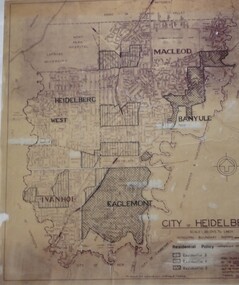
Map, City of Heidelberg: Residential Policy, 1976c
... City of Heidelberg: Residential Policy...city of heidelberg...City of Heidelberg...Scale: 20 chs to 1 inch City of Heidelberg: Residential Policy Map City of Heidelberg ...Shows residential zones 3, 4 & 5 established by Residential Policy adopted 13/12/1976Black print on waxed paper. Scale: 20 chs to 1 inchG M Hutchins. $1city of heidelberg, heidelberg -
 Greensborough Historical Society
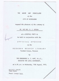
Memorabilia - Invitation, City of Heidelberg, City of Heidelberg Cocktail party to be held in conjunction with official opening of the Rosanna Branch Library 1973, 18/07/1973
... City of Heidelberg Cocktail party to be held in conjunction with official opening of the Rosanna Branch Library 1973......city of heidelberg...City of Heidelberg...This collection was compiled by his wife, Mavis Morgan, detailing the events they attended in their official capacity. bruce morgan mavis morgan shire of diamond valley city of heidelberg rosanna library Invitation on cream paper, black text City of Heidelberg Cocktail party to be held in conjunction with official opening of the Rosanna Branch Library 1973 Memorabilia Invitation City of Heidelberg ...Invitation to a Cocktail Party to be held in conjunction with the Official Opening of the Rosanna Branch Library by The Honourable A.J. Hunt, M.L.C., Minister for Local Government, 15th August, 1973. Bruce Morgan was the first Shire Secretary (1964-1983) of the Shire of Diamond Valley. This collection was compiled by his wife, Mavis Morgan, detailing the events they attended in their official capacity.Invitation on cream paper, black textbruce morgan, mavis morgan, shire of diamond valley, city of heidelberg, rosanna library -
 Greensborough Historical Society
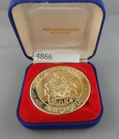
Medallion, Brim Medallions, Golden Jubilee medallion - City of Heidelberg 1934-1984, 1934-1984
... Golden Jubilee medallion - City of Heidelberg 1934-1984...city of heidelberg...Medallion produced for the Jubilee celebrations of the City of Heidelberg in 1984. This medallion was given to council staff...."Golden Jubilee commemorating the proclamation of the City of Heidelberg 1934-1984"...Greensborough Historical Society 34A Glenauburn Road Lower Plenty Lower Plenty melbourne Medallion produced for the Jubilee celebrations of the City of Heidelberg in 1984. This medallion was given to council staff. city of heidelberg heidelberg "Golden Jubilee commemorating the proclamation of the City of Heidelberg 1934-1984" Gilt medallion in blue mock velveteen case Golden Jubilee medallion - City of Heidelberg 1934-1984 Medallion Brim Medallions ...Medallion produced for the Jubilee celebrations of the City of Heidelberg in 1984. This medallion was given to council staff.Gilt medallion in blue mock velveteen case"Golden Jubilee commemorating the proclamation of the City of Heidelberg 1934-1984"city of heidelberg, heidelberg -
 Greensborough Historical Society
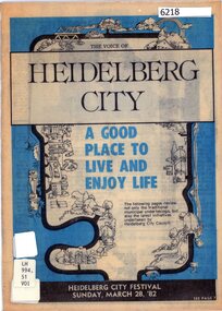
Booklet, City of Heidelberg, The Voice of Heidelberg City, 1981
... The Voice of Heidelberg City...city of heidelberg...Information booklet about Heidelberg City Council services and activities in 1982...City of Heidelberg...Greensborough Historical Society 34A Glenauburn Road Lower Plenty Lower Plenty melbourne Information booklet about Heidelberg City Council services and activities in 1982 city of heidelberg heidelberg city council YPRL labels 16 p., black and white illustrations The Voice of Heidelberg City Booklet Booklet City of Heidelberg City of Heidelberg ...Information booklet about Heidelberg City Council services and activities in 198216 p., black and white illustrationsYPRL labelscity of heidelberg, heidelberg city council -
 Greensborough Historical Society
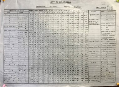
Poster - Diagram, Pedestrian crossing traffic densities, by City of Heidelberg, 1958_
... Pedestrian crossing traffic densities, by City of Heidelberg...City of Heidelberg...Readings were taken at 34 pedestrian crossings in the Heidelberg and Greensborough areas, of pedestrians and vehicles at hourly intervals between 8 am and 6 pm on four Fridays in August and September 1958 traffic heidelberg greensborough Table of pedestrian counts, text and numeric values Pedestrian crossing traffic densities, by City of Heidelberg Poster Diagram City of Heidelberg ...Readings were taken at 34 pedestrian crossings in the Heidelberg and Greensborough areas, of pedestrians and vehicles at hourly intervals between 8 am and 6 pm on four Fridays in August and September 1958Table of pedestrian counts, text and numeric valuestraffic, heidelberg, greensborough -
 Kew Historical Society Inc
Plan, City Engineers Department (Heidelberg), City of Heidelberg Plan: Scale 20 chns to 1 inch, 1970-1993
... City of Heidelberg Plan: Scale 20 chns to 1 inch...city of heidelberg...Plan of number of areas in the City of Heidelberg showing municipal and ward boundaries, subsequently annotated by the historian Gwen McWilliam, identifying significant landholdings, subdivisions and key dates.The base map was printed in 1970 and annotated c.1993. ... City Engineers Department (Heidelberg)...The plan was donated to the Kew Historical Society by Gwen McWilliam. City of Heidelberg Plan: Scale 20 chns to 1 inch Plan City Engineers Department (Heidelberg) Gwen McWilliam ...Gwen Barton McWilliam (nee: Nelson), OAM, BA (1933- ). Gwen McWilliam is well known as an authority on the history of Boroondara and the author of a large number of books and pamphlets about the City. She was awarded the medal of the Order of Australia in 2001 ‘for service to the community of Hawthorn and district, particularly through the research, documentation and publication of its history.’ Primary source annotated by a distinguished local historian.Plan of number of areas in the City of Heidelberg showing municipal and ward boundaries, subsequently annotated by the historian Gwen McWilliam, identifying significant landholdings, subdivisions and key dates.The base map was printed in 1970 and annotated c.1993. The plan was donated to the Kew Historical Society by Gwen McWilliam. Handwritten annotations by Gwen McWilliam, 1993city of heidelberg, maps -- heidelberg (vic.), gwen mcwilliam -
 Greensborough Historical Society
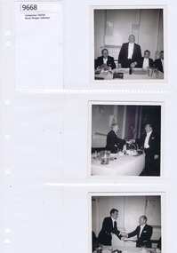
Memorabilia - Photograph, City of Heidelberg Mayoral Changeover
... City of Heidelberg Mayoral Changeover......city of heidelberg...Photo of the handover of the Presidential Chain for the City of Heidelberg...City of Heidelberg Mayoral Changeover Memorabilia Photograph ...Photo of the handover of the Presidential Chain for the City of HeidelbergBruce Morgan was the first Shire Secretary (1964-1983) of the Shire of Diamond Valley. This collection was compiled by his wife, Mavis Morgan, detailing the events they attended in their official capacitySmall black and white photograph.bruce morgan, mavis morgan, city of heidelberg -
 Greensborough Historical Society
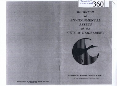
Booklet, Register of environmental assets of the City of Heidelberg 1977, 1978_
... Register of environmental assets of the City of Heidelberg 1977.......city of heidelberg...This is the first list of environmental assets within the City of Heidelberg (1977) and lists major parklands, small neighbourhood parks, trees of note and landscapes....Register of environmental assets of the City of Heidelberg 1977. Booklet Warringal Conservation Society ...This is the first list of environmental assets within the City of Heidelberg (1977) and lists major parklands, small neighbourhood parks, trees of note and landscapes.An early list of environmental assets in Heidelberg, has been superseded by Strategies and Policies on the Banyule Council website.Photocopy of 28 page booklet. Copied 2 pages to an A4 sheet. heidelberg, environmental assets, city of heidelberg, parks -
![Invitation [copy], Invitation to the Proclamation of Heidelberg as a City, 1934, 14/11/1934](/media/collectors/4f729f5697f83e03086015b8/items/5109c3b72162ef11145d961f/item-media/57c54cf5d0cdd10a24fd2d07/item-fit-380x285.jpg?cb=6) Greensborough Historical Society
Greensborough Historical SocietyInvitation [copy], Invitation to the Proclamation of Heidelberg as a City, 1934, 14/11/1934
... Invitation to the Proclamation of Heidelberg as a City, 1934....city of heidelberg...This was an invitation to the President of the Greensborough RSSILA and his wife to attend the Proclamation of the City of Heidelberg. ...City of Heidelberg...Invitation to the Proclamation of Heidelberg as a City, 1934. Invitation [copy] City of Heidelberg ...This was an invitation to the President of the Greensborough RSSILA and his wife to attend the Proclamation of the City of Heidelberg. Commemorates the Proclamation of Heidelberg as a City on 14th November 1934.An A4 photocopy of a certificate.Nilcity of heidelberg, lord huntingfield, invitations, hardley, warringal park -
 Greensborough Historical Society
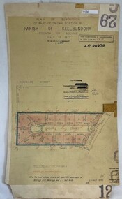
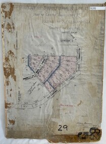
Poster - Planning Document, City of Heidelberg, Subdivision Plan # G 29 Part 2, Crown portion 16, Greensborough, 1951
... ...city of heidelberg...Plan of Subdivisions in City of Heidelberg: Parish of Keelbundoora: Crown portion 16 - Daours Court and Devonshire Road, 1951....City of Heidelberg...Subdivision Plan # G 29 Part 2, Crown portion 16, Greensborough Poster Planning Document City of Heidelberg ...Plan of Subdivisions in City of Heidelberg: Parish of Keelbundoora: Crown portion 16 - Daours Court and Devonshire Road, 1951.An example of hard copy subdivision plans from the Greensborough area. Mainly from the Shire of Diamond Valley era (1964-1994).Plan (single sided) mounted on heavy card. Stamped and handwritten Council permissions, dates and other details.subdivision plans, city of heidelberg -
 Greensborough Historical Society
Poster - Planning Document, City of Heidelberg, Subdivision Plan # G 29 Part 1, Crown allotment 17, Greensborough, 1922
... ...city of heidelberg...Plan of Subdivisions in City of Heidelberg: Parish of Keelbundoora: Crown allotment 17 - Warwick Road, Clydbank Street, Alexandra Street, 1922....City of Heidelberg...Subdivision Plan # G 29 Part 1, Crown allotment 17, Greensborough Poster Planning Document City of Heidelberg ...Plan of Subdivisions in City of Heidelberg: Parish of Keelbundoora: Crown allotment 17 - Warwick Road, Clydbank Street, Alexandra Street, 1922.An example of hard copy subdivision plans from the Greensborough area. Mainly from the Shire of Diamond Valley era (1964-1994).Plan (single sided) mounted on heavy card. Stamped and handwritten Council permissions, dates and other details.subdivision plans, city of heidelberg -
 Greensborough Historical Society
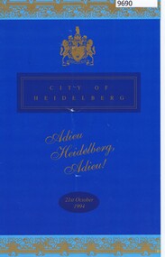
Programme - Program, City of Heidelberg, Adieu Heidelberg Adieu!, 21/10/1994
... city of heidelberg...The City of Heidelberg celebrated its history with a dinner to celebrate the past and look forward to the future following local government amalgamations in 1994. ...City of Heidelberg...Programme Program City of Heidelberg ...The City of Heidelberg celebrated its history with a dinner to celebrate the past and look forward to the future following local government amalgamations in 1994. The City of Heidleberg became the City of Banyule.Programme in colour with colour and black and white pictures and black textcity of heidelberg, heidelberg, local government amalgamation 1994, banyule city council -
 Greensborough Historical Society
Booklet, Heidelberg 1937 - excerpts, 1937_04
... Copy of parts of 1937 booklet to commemorate the official opening of the City of Heidelberg Civic Centre - Town Hall and Municipal Offices....This flyer is an extract of images from the City of Heidelberg Civic Centre Official Opening Booklet "Heidelberg 1937" [footnote on each page]...City of Heidelberg...Heidelberg 1937 - excerpts Booklet Booklet City of Heidelberg ...Copy of parts of 1937 booklet to commemorate the official opening of the City of Heidelberg Civic Centre - Town Hall and Municipal Offices.A snapshot of the Heidelberg area in 1937, includes photos of local homes and civic amenities12 pages, photocopied and folded to A5 size. Black and white photos, maps.This flyer is an extract of images from the City of Heidelberg Civic Centre Official Opening Booklet "Heidelberg 1937" [footnote on each page]heidelberg municipal offices, heidelberg town hall, the centre ivanhoe -
 Greensborough Historical Society
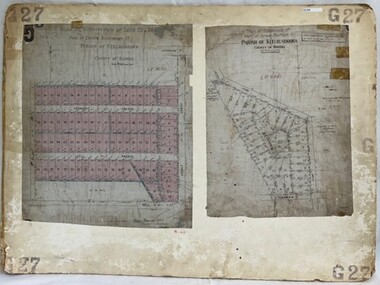
Poster - Planning Document, City of Heidelberg, Subdivision Plan # G 27, Greensborough and Diamond Creek, 1922 and 1963
... ...city of heidelberg...Plan of Subdivisions in City of Heidelberg: Side 1: 2 plans, Parish of Keelbundoora: plan 1: Henry Street, Vermont Avenue, Lyell Street, Nell Street, McDowell Street, 1922. ...City of Heidelberg...Subdivision Plan # G 27, Greensborough and Diamond Creek Poster Planning Document City of Heidelberg ...Plan of Subdivisions in City of Heidelberg: Side 1: 2 plans, Parish of Keelbundoora: plan 1: Henry Street, Vermont Avenue, Lyell Street, Nell Street, McDowell Street, 1922. Plan 2: Henry Street, Nepean Street, Charles Street, 1922. Side 2: 2 plans Parish of Nillumbik, Portion 13: Plan 1: Diamond Creek Road, Delfin Crescent, Ridge Road, 1963. Plan 2: Kinglake Road, Eltham Road, 1963.An example of hard copy subdivision plans from the Greensborough area. Mainly from the Shire of Diamond Valley era (1964-1994).Plan (2 sided) mounted on heavy card. Contains 2 sheets pasted together.Stamped and handwritten Council permissions, dates and other details.subdivision plans, city of heidelberg