Showing 444 items matching "coastline"
-
 Phillip Island and District Historical Society Inc.
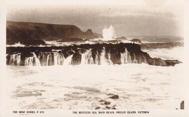
Photograph, Southern Coastline of Phillip Island, c 1926
... Southern Coastline of Phillip Island......coastline...Sepia Postcard of the southern coastline of Phillip Island The Rose Series P 670...Phillip Island and District Historical Society Inc. phillip-island-and-the-bass-coast local history postcards back beach phillip island sepia photograph ian reiher coastline The Rose Series. P 670 The restless sea, Back Beach, Phillip Island, Victoria Sepia Postcard of the southern coastline of Phillip Island The Rose Series P 670 Southern Coastline of Phillip Island Photograph Photograph ...Sepia Postcard of the southern coastline of Phillip Island The Rose Series P 670The Rose Series. P 670 The restless sea, Back Beach, Phillip Island, Victorialocal history, postcards, back beach, phillip island, sepia photograph, ian reiher, coastline -
 Ballarat Heritage Services
Photograph - Colour, Undercute Coastline around Thunder Point, Warrnambool, 2019, 27/12/2019
... Undercute Coastline around Thunder Point, Warrnambool, 2019...Colour photos of undercut coastline around Thunder Point, Warrnambool....Undercute Coastline around Thunder Point, Warrnambool, 2019 Photograph - Colour Clare Gervasoni Lisa Gervasoni ...Colour photos of undercut coastline around Thunder Point, Warrnambool.warrnambool, thunder point, low tide, rocky coast -
 Wangaratta Art Gallery
Painting, Len Pawluk, Otway Coastline, 2005
... Otway Coastline...Obverse: L Pawluk/ 2005/ (bottom left) Wangaratta Art Show - 2005/ ** Grand Winner **/ 'Otway Coastline' - Artist: Len Pawluk/ Judge: Wykeham Perry/ (plaque mounted on frame) ...Otway Coastline Painting Len Pawluk ...Rural City of Wangaratta Collection, Wangaratta Art Prize 2005.A coastal landscape of people frolicking on the beach of an inlet, painted in oil using blues, browns, yellows, and whites.Obverse: L Pawluk/ 2005/ (bottom left) Wangaratta Art Show - 2005/ ** Grand Winner **/ 'Otway Coastline' - Artist: Len Pawluk/ Judge: Wykeham Perry/ (plaque mounted on frame) wangaratta art gallery, len pawluk, landscape, painting, coastal, otway -
 Mission to Seafarers Victoria
Book, Gollock, G. A. (Georgina Anne), 1861-1940, At the sign of the flying angel : a book of the sailor at the coastline, 1930
... At the sign of the flying angel : a book of the sailor at the coastline...At the sign of the flying angel : a book of the sailor at the coastline Book Book Gollock, G. A. (Georgina Anne), 1861-1940 Longmans, Green & Co. ...This book documents help and guidance provided by the Christian church to merchant seafarers as they traverse the world, particularly at their points of departure and arrival, and the interactions and activities that they are involved in at these ports.Medium--sized hardcover book of 244 pages. Cover of mid-blue colour, blank front and back covers, book title and author at top of spine in gold print. Book contains a number of illustrations and maps. London : Longmans, Green and Co., 1930 xi., 244 p., [16] leaves of plates : ill., maps, 2 ports. ; 20 cm. non-fictionThis book documents help and guidance provided by the Christian church to merchant seafarers as they traverse the world, particularly at their points of departure and arrival, and the interactions and activities that they are involved in at these ports.flying angel, reverend alfred gurney goldsmith, georgina anne gollock, ethel augusta godfrey 1861-1935, alice sibthorpe tracy -
 National Vietnam Veterans Museum (NVVM)
Journal, The Coastline Guardian (18 issues)
... The Coastline Guardian (18 issues)....Australian 18 issues printed in Vietnam during the Vietnam War presumably by Australian soldiers. The Coastline Guardian (18 issues). Journal Journal ...18 issues printed in Vietnam during the Vietnam War presumably by Australian soldiers.vietnam war, 1961 - 1975, personal narratives - australian, vietnam war, 1961-1975 - participation. australian -
 Bayside Gallery - Bayside City Council Art & Heritage Collection
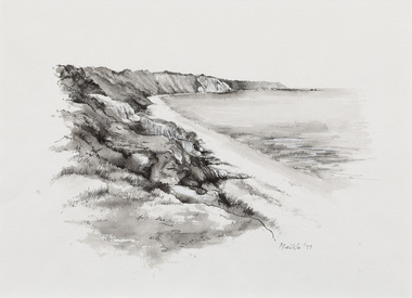
Work on paper - ink and watercolour, Annette Meikle, Coastline and Red Bluff, 1977
... Coastline and Red Bluff...Meikle went on to donate 22 of these sketches to Bayside City Council in 2003. annette meikle sandringham sketchbook elizabeth waters bay port phillip bay Coastline and Red Bluff Red Bluff Cliffs Coast Coastline and Red Bluff Work on paper ink and watercolour Annette Meikle ...In 1977, artist Annette Meikle undertook a commission to illustrate a book recording stories of places and people in the Bayside area. It was published in 1978 as Sandringham Sketchbook, with text by Elizabeth Waters. The sketches were intended to record remaining examples of Bayside’s early architecture and environment, as well as reflect newer architectural changes. Meikle went on to donate 22 of these sketches to Bayside City Council in 2003.Annette Meikle, Coastline and Red Bluff 1977, ink and watercolour, 25.9 x 25.5 cm. Bayside City Council Art and Heritage Collection. Donated by the artist, 2003annette meikle, sandringham sketchbook, elizabeth waters, bay, port phillip bay, coastline and red bluff, red bluff cliffs, coast -
 Inverloch Historical Society
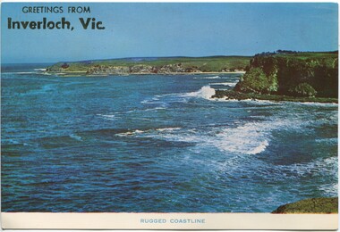
004373 Postcard Photograph - Greetings from Inverloch - Rugged Coastline - from Graham Paterson
... 004373 Postcard Photograph - Greetings from Inverloch - Rugged Coastline - from Graham Paterson...Inverloch gippsland 004373 Postcard Photograph - Greetings from Inverloch - Rugged Coastline - from Graham Paterson ... -
Lakes Entrance Historical Society
Book, Gippsland Coastal Board, Gippsland Regional Coastline Plan 2015 - 2020, 2015
... Gippsland Regional Coastline Plan 2015 - 2020...Lakes Entrance Historical Society 4 Marine Parade Lakes Entrance gippsland Waterways Tourism Environment Booklet containing the draft plan of managing the Gippsland coastal region respecting the social economic and enviromental values for residents and visitors to Gippsland Victoria Gippsland Regional Coastline Plan 2015 - 2020 Book Gippsland Coastal Board ...Booklet containing the draft plan of managing the Gippsland coastal region respecting the social economic and enviromental values for residents and visitors to Gippsland Victoriawaterways, tourism, environment -
 Peterborough History Group
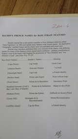
Document - Explorers of Australian coastline
... Explorers of Australian coastline...Outlines early European observation of the coastline. baudin peterborough peterborough history le geographe Newspaper clipping, copies maps Explorers of Australian coastline Document Explorers of Australian coastline ...information pertaining to Captain Cook and French sailor Baudin. Includes French names which he assigned to coastal features.Outlines early European observation of the coastline.Newspaper clipping, copies mapsbaudin, peterborough, peterborough history, le geographe -
 Phillip Island and District Historical Society Inc.
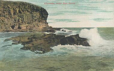
Photograph - Post Card
... ...coastline...Colour postcard of the Kilcunda coastline, near San Remo...Phillip Island and District Historical Society Inc. phillip-island-and-the-bass-coast One of a collection of photographs donated by Shirley Peterson kilcunda victoria coastline shirley peterson "Kilcunda, new San Remo" On back: "Victorian Railways Tourist Series" For particulars as to Fares, Times, etc., consult "Picturesque Victoria" Current Time Table, Inquiry Office, Melbourne, or Local Station-master" Colour postcard of the Kilcunda coastline, near San Remo Photograph - Post Card Victorian Railways Tourist Series ...One of a collection of photographs donated by Shirley PetersonColour postcard of the Kilcunda coastline, near San Remo"Kilcunda, new San Remo" On back: "Victorian Railways Tourist Series" For particulars as to Fares, Times, etc., consult "Picturesque Victoria" Current Time Table, Inquiry Office, Melbourne, or Local Station-master"kilcunda victoria, coastline, shirley peterson -
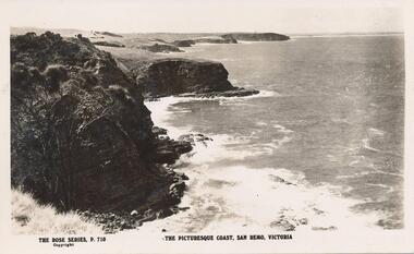 Phillip Island and District Historical Society Inc.
Photograph - Post Card, 1920's
... ...coastline...Black & White postcard showing the rugged coastline at San Remo....Phillip Island and District Historical Society Inc. phillip-island-and-the-bass-coast One of a collection of photographs donated by Steve Stefan, Archivist, St Frances Church, Melbourne san remo coastline coastline steve stefan "The Rose Series, P. 710" "The picturesque coast, San Remo, Victoria" Black & White postcard showing the rugged coastline at San Remo. ...One of a collection of photographs donated by Steve Stefan, Archivist, St Frances Church, MelbourneBlack & White postcard showing the rugged coastline at San Remo."The Rose Series, P. 710" "The picturesque coast, San Remo, Victoria"san remo coastline, coastline, steve stefan -
 Ballarat Heritage Services
Photograph - Colour, Clare Gervasoni, Rosebud Pier, 2018, 11/06/2018
... ...coastline...Colour photograph of the coastline around the Rosebud Pier, Victoria....Ballarat Heritage Services PO Box 2209 Bakery Hill Post Office goldfields rosebud rosebud pier beach beach coastline Colour photograph of the coastline around the Rosebud Pier, Victoria. ...Colour photograph of the coastline around the Rosebud Pier, Victoria.rosebud, rosebud pier, beach, beach, coastline -
 Bendigo Military Museum
Photograph - 4th Field Survey Squadron – Operation ARIGHT 91, Queensland, 1991
... ...Southern Coastline, PNG ...This is a set of 16 photographs taken during 4th Field Survey Squadron’s deployment on Operation ARIGHT 91 in Queensland from the 8th of July to the 5th of September 1991. The area of operations was the top end of the Cape York Peninsula, islands of the Torres Strait and the southern coast of PNG. Field parties utilised Texas Instruments TI4100 Global Positioning System receivers. Concurrent with GPS operations Doppler point positioning observations were carried out by field parties using Magnavox MX 1502 receivers on six of the control points. Two Bell UH-1H Iroquois helicopters from RAAF’s 171 COMD and Liaison Squadron were primarily used to deploy GPS field parties. Identification photography of control points was taken by air camera operators in AAAvn Pilatus Porter aircraft from 173 Gen Spt Sqn fitted with an RC10 aerial camera.This is a set of 16 photographs taken in 1991 during 4th Field Survey Squadron’s deployment on Operation ARIGHT in Queensland. The colour photographs are on 35mm negative film and are part of the Army Survey Regiment’s Collection. The photographs were scanned at 96 dpi. .1) to .3) - Photo, colour, 1991. Area of Operations (AO) coordination maps. .4) - Photo, colour, 1991. GPS acquisition post-processing. L to R: LT Simon Buckpitt, SSGT Steve Winner, WO2 Ken Talbot-Smith. .5) to .6) - Photo, colour, 1991. Base camp unidentified personnel. .7) - Photo, colour, 1991. L to R: OPS WO - WO2 Ken Talbot-Smith, DET SSM WO1 Stevo Hinic. .8) - Photo, colour, 1991. Base camp unidentified personnel. .9) - Photo, colour, 1991. Base camp L to R: unidentified (x2), OPS WO - WO2 Ken Talbot-Smith. .10) - Photo, colour, 1991. Base camp unidentified soldier. .11) - Photo, colour, 1991. Base camp L to R: CPL Andy Love, unidentified, SGT Steve McGuiness. .12) - Photo, colour, 1991. Base camp at Horn Island Army Compound. .13 to .16) - Photo, colour, 1991. Unknown locations in Area of Operations..1P to .16P – There are no personnel identified. ‘1991 OP ARIGHT’ annotated on negative sleeve.royal australian survey corps, rasvy, 4 fd svy sqn, op aright 91 -
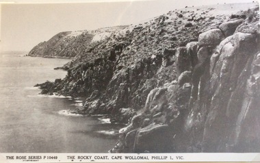 Phillip Island and District Historical Society Inc.
Photograph, Rocky coast, Cape Woolamai
... ...coastline...View of Cape Woolamai showing the rugged nature of the coastline. Calm seas....Copied by John Jansson 1984 local history photography photographs postcards cape woolamai phillip island black & white postcard copy coastline The Rose Series P.10449. The Rocky Coast, Cape Wollomai, Phillip Island Victoria View of Cape Woolamai showing the rugged nature of the coastline. ...Part of a collection of 'Rose & Valentine' series of Post Cards. Copied by John Jansson 1984View of Cape Woolamai showing the rugged nature of the coastline. Calm seas.The Rose Series P.10449. The Rocky Coast, Cape Wollomai, Phillip Island Victorialocal history, photography, photographs, postcards, cape woolamai, phillip island, black & white postcard copy, coastline -
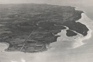 Phillip Island and District Historical Society Inc.
Photograph, Bryant West
... ...coastline...Aerial Photograph of Northern Coastline of Phillip Island with Rhyll in the foreground....Phillip Island and District Historical Society Inc. phillip-island-and-the-bass-coast One of a collection of over 400 photographs in an album commenced in 1960 and presented to the Phillip Island & Westernport Historical Society by the Shire of Phillip Island local history photography photographs northern coastline phillip island rhyll coastline cowes john jenner bryant west Aerial Photograph of Northern Coastline of Phillip Island with Rhyll in the foreground. ...One of a collection of over 400 photographs in an album commenced in 1960 and presented to the Phillip Island & Westernport Historical Society by the Shire of Phillip IslandAerial Photograph of Northern Coastline of Phillip Island with Rhyll in the foreground.local history, photography, photographs, northern coastline, phillip island, rhyll, coastline, cowes, john jenner, bryant west -
Glenelg Shire Council Cultural Collection
Photograph - Photograph - aerial view of Portland, c. 1954
... ... coastline...Black and white aerial photograph of coastline around Portland. Black border, scale all sides, 5 rows of 3 't' at regular intervals. ...Glenelg Shire Council Cultural Collection History House Cliff Street Portland great-ocean-road aerial photography central Portland Portland Harbour coastline Front: '820 -9' - handwritten, white, border 'RUN 5' 'PORTLAND', printed, white, lower border Black and white aerial photograph of coastline around Portland. ...Black and white aerial photograph of coastline around Portland. Black border, scale all sides, 5 rows of 3 't' at regular intervals. Small area of ocean, rest land with lakes.Front: '820 -9' - handwritten, white, border 'RUN 5' 'PORTLAND', printed, white, lower borderaerial photography, central portland, portland harbour, coastline -
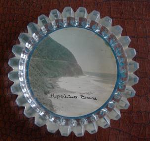 Victorian Interpretive Projects Inc.
Image of souvenir ware, Apollo Bay
... A coloured picture of a coastline attached to a glass butter plate. The coastline is Cape Patton, Apollo Bay, Victoria...(http://en.wikipedia.org/wiki/Apollo_Bay) Apollo Bay beach coast souvenir "Apollo Bay" A coloured picture of a coastline attached to a glass butter plate. The coastline is Cape Patton, Apollo Bay, Victoria Apollo Bay Image of souvenir ware ...Apollo Bay is located between Wye River and Cape Otway on Victoria's scenic coastal route, the Great Ocean Road. In the 1840s the Henty brothers established a whaling station at Point Bunbury on the western end of the bay. The bay was named by Captain Loutit in 1845 when he sheltered his vessel, the Apollo during a storm. (http://en.wikipedia.org/wiki/Apollo_Bay)A coloured picture of a coastline attached to a glass butter plate. The coastline is Cape Patton, Apollo Bay, Victoria"Apollo Bay"apollo bay, beach, coast, souvenir -
 Robin Boyd Foundation
Slide, Robin Boyd
... Colour slide in a mount. Coastline...Robin Boyd Foundation 290 Walsh Street South Yarra melbourne slide robin boyd Made in Australia / 14 / Encircled 39a (Handwritten) Colour slide in a mount. Coastline Slide Robin Boyd ...Colour slide in a mount. CoastlineMade in Australia / 14 / Encircled 39a (Handwritten)slide, robin boyd -
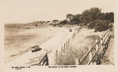 Phillip Island and District Historical Society Inc.
Photograph, 1920's
... ...coastline...Sepia print of San Remo coastline at low tide with dinghy at left foreground. ...The beach at San Remo - Victoria Sepia print of San Remo coastline at low tide with dinghy at left foreground. ...Sent as Happy Birthday wishes from "mother" Feb 18 1923. Part of a collection donated by Edith Elms via Chrisy Northcote.Sepia print of San Remo coastline at low tide with dinghy at left foreground. Two fences traversing from bottom to 3/4 where trees merge, sailboat beached at centre. Pier at 3/4 left top.The Rose Series, P764. The beach at San Remo - Victorialocal history, photography, photographs, san remo, coastline, sepia photograph, coastal views -
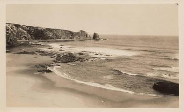
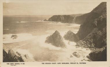 Phillip Island and District Historical Society Inc.
Sepia Photograph, 1920's
... Photograph of the rugged coastline at Cape Woolamai...Photo shows rugged rocks with wavers breaking around the shoreline. phillip island cape woolamai rugged coastline earl of stradbroke The Rose Series P. 681. ...This album was presented to the Earl of Stradbroke by the Fathers of Soldiers and Returned Soldiers 16/2/1923. Photo shows rugged rocks with wavers breaking around the shoreline.Photograph of the rugged coastline at Cape WoolamaiThe Rose Series P. 681. The rugged coast, Cape Woolamai, Phillip is., Victoriaphillip island, cape woolamai, rugged coastline, earl of stradbroke -
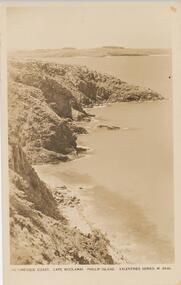 Phillip Island and District Historical Society Inc.
Photograph - Post Card, 1920's
... Sepia postcard of the Cape Woolamai coastline....Phillip Island and District Historical Society Inc. phillip-island-and-the-bass-coast One of 17 photographs donated by Olive Blamey cape woolamai coastline coastline phillip island phillip island olive blamey "Picturesque Coast, Cape Woolamai, Phillip Island." ...One of 17 photographs donated by Olive BlameySepia postcard of the Cape Woolamai coastline."Picturesque Coast, Cape Woolamai, Phillip Island." "Valentine Series M 4846" On back: "Marie, with birthday greetings, from Heath Hill. 18.12.1925.cape woolamai coastline, coastline phillip island, phillip island, olive blamey -
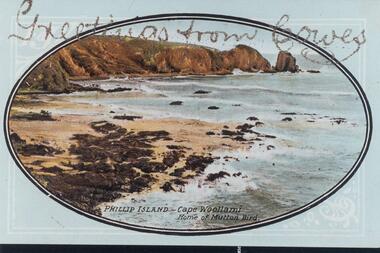 Phillip Island and District Historical Society Inc.
Photograph - Post Card, Unknown
... Coloured postcard of Cape Woollamai coastline....Phillip Island and District Historical Society Inc. phillip-island-and-the-bass-coast One of 16 photographs and postcards donated by Mary Karney rocky cliffs at cape woolamai cape woolamai coastline cape woolamai phillip island coastline mary karney "Greeting from Cowes" "Phillip Island - Cape Woollami Home of Mutton Bird" Coloured postcard of Cape Woollamai coastline. ...One of 16 photographs and postcards donated by Mary KarneyColoured postcard of Cape Woollamai coastline."Greeting from Cowes" "Phillip Island - Cape Woollami Home of Mutton Bird"rocky cliffs at cape woolamai, cape woolamai, coastline cape woolamai, phillip island coastline, mary karney -
 Ballarat Heritage Services
Photograph - Colour, Clare Gervasoni, Rosebud, 2018, 11/06/2018
... Colour photograph of the coastline at Rosebud Beach....Ballarat Heritage Services PO Box 2209 Bakery Hill Post Office goldfields rosebud rosebud pier beach Colour photograph of the coastline at Rosebud Beach. Rosebud, 2018 Photograph - Colour Clare Gervasoni ...Colour photograph of the coastline at Rosebud Beach.rosebud, rosebud pier, beach -
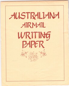 Emerald Museum & Nobelius Heritage Park
Domestic object - Airmail writing pad and two aerogrammes, Ken Dome, 1980s-1990s
... The second aerogramme has a photograph of Australian coastline and cost 65c and so was released on or after 1993. ...Also, two aerogrammes - one is 60c and has a colourful drawing of a Melbourne tram and the other is 65c and has a photograph of the Australian coastline....The second aerogramme has a photograph of Australian coastline and cost 65c and so was released on or after 1993. ...This writing pad has lightweight paper to minimise cost for international mail. The Australiana theme is a way of promoting Australia to the overseas recipient of the letter. One of the two aerogrammes cost 60c and has an illustration of a Melbourne tram by Australian artist Ken Dome This was one of four designs which he created for aerogrammes and released in 1989. The second aerogramme has a photograph of Australian coastline and cost 65c and so was released on or after 1993. These writing materials are a reminder of a time when ordinary communications across countries were primarily undertaken through letters carried by plane.Writing pad consisting of lightweight manilla-coloured pages in four different Australiana-themed designs. Eleven pages. (Originally twelve). Also, two aerogrammes - one is 60c and has a colourful drawing of a Melbourne tram and the other is 65c and has a photograph of the Australian coastline.On front cover of writing pad: ' AUSTRALIANA / AIRMAIL /WRITING / PAPER' On back cover of writing pad: 'Four Designs / Twelve Sheets / Post Office Approved' on one side and on the other side: 'Designed and Printed / in Australia by / AUSIROO'. On front of the 60c aerogramme: 'BY AIR MAIL PAR AVION / Aerogramme / Australia 60c' On front of the 65c aerogramme: 'BY AIR MAIL PAR AVION / Aerogramme / Australia 65c'aerogramme, australiana, ken dome -
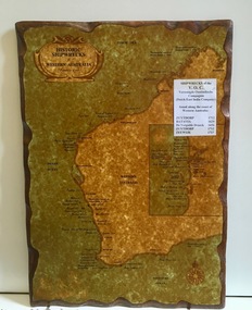 Dutch Australian Heritage Centre Victoria
Wooden Plaque
... In the 17th century accurate navigation was not always possible and ships might end up on the wild, unchartered West Australian coastline. ...Coastal cities are marked with their names and dots along the coastline indicate wreck sites. Most are named and dated; others marked as unidentified. ...Coastal cities are marked with their names and dots along the coastline indicate wreck sites. Most are named and dated; others marked as unidentified. ...The VOC sent its trading ships to the (then) Dutch East Indies to collect spices and other goods. In the 17th century accurate navigation was not always possible and ships might end up on the wild, unchartered West Australian coastline. Item recalls the fact that the WA coast was unintentionally visited by Dutch ships during the 17th and 18th centuries. Because the coast was so unattractive the Dutch did not try to settle the country.Large rectangular timber plaque with scalloped edges depicting historic shipwrecks of Western Australia.An insert reads: "Historic Shipwrecks of Western Australia (Protected as of 1983). Coastal cities are marked with their names and dots along the coastline indicate wreck sites. Most are named and dated; others marked as unidentified. An inset map deals with the area around Fremantle and shows a large number of wrecks. A separate typed notice attached to the map identifies the five known Dutch wrecks - all ships of the VOC - Vereennigde East Indian Compagnie (Dutch East India Company). Further than that there are a distance scale and a compass. -
 Robin Boyd Foundation
Slide, Robin Boyd, 1967
... Colour slide in a mount. Coastline, unknown location...Robin Boyd Foundation 290 Walsh Street South Yarra melbourne slide robin boyd Made in Australia / 16 / JUN 67M1 / Encircled 12 (Handwritten) Colour slide in a mount. Coastline, unknown location Slide Robin Boyd ...Colour slide in a mount. Coastline, unknown locationMade in Australia / 16 / JUN 67M1 / Encircled 12 (Handwritten)slide, robin boyd -
 Ballarat Heritage Services
Digital photograph, Lisa Gervasoni, Cape Bridgewater, c2015
... Colour photograph of the coastline at Cape Bridgewater, Victoria. ...Ballarat Heritage Services PO Box 2209 Bakery Hill Post Office goldfields cape bridgewater geology ocean coastal landscape seascape blowhole volcanic rock Colour photograph of the coastline at Cape Bridgewater, Victoria. Cape Bridgewater Digital photograph Lisa Gervasoni ...Colour photograph of the coastline at Cape Bridgewater, Victoria. cape bridgewater, geology, ocean, coastal, landscape, seascape, blowhole, volcanic rock -
 Phillip Island and District Historical Society Inc.
Photograph, 1907
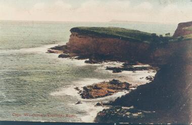
... Coloured copy of a postcard showing Cape Woolamai coastline...Coloured copy of a postcard showing Cape Woolamai coastline Photograph Photograph ...One of a collection of photographs donated by Bruce BennettColoured copy of a postcard showing Cape Woolamai coastline"Cape Woolamai, Victoria, Austr."cape woolamai, coastline cape woolamai, bruce bennett -
 Phillip Island and District Historical Society Inc.
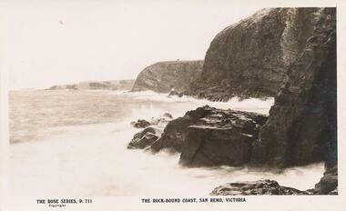
Photograph - Post Card, Early 20th Century
... Black & White postcard of the Rocky coastline at San Remo...Phillip Island and District Historical Society Inc. phillip-island-and-the-bass-coast One of a collection of Photographs donated by Steve Stefan, Archivist, St Frances Church, Melbourne san remo coastline rocky coastline san remo victoria "The Rose Series, P. 711" "The Rock-bound Coast, San Remo, Victoria" Black & White postcard of the Rocky coastline at San Remo Photograph - Post Card The Rose Stereographs ...One of a collection of Photographs donated by Steve Stefan, Archivist, St Frances Church, MelbourneBlack & White postcard of the Rocky coastline at San Remo"The Rose Series, P. 711" "The Rock-bound Coast, San Remo, Victoria"san remo coastline, rocky coastline san remo victoria -
 Phillip Island and District Historical Society Inc.
Photograph, Unknown
... Black & White photograph of Cape Woolamai cliffs and coastline....Phillip Island and District Historical Society Inc. phillip-island-and-the-bass-coast One of 6 photographs donated by M Batty. cape woolamai coastline cape woolamai shoreline phillip island shoreline phillip island coastline phillip island m batty Black & White photograph of Cape Woolamai cliffs and coastline. ...One of 6 photographs donated by M Batty.Black & White photograph of Cape Woolamai cliffs and coastline.cape woolamai coastline, cape woolamai shoreline, phillip island shoreline, phillip island coastline, phillip island, m batty