Showing 15 items matching "coimadai"
-
 Bacchus Marsh & District Historical Society
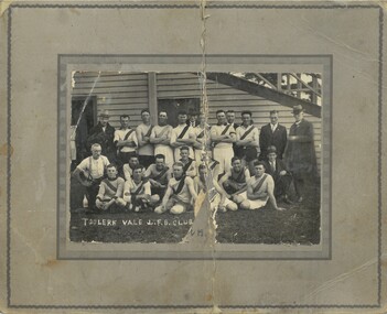
Photograph, Toolern Vale and Coimadai Football Team 1928
... Toolern Vale and Coimadai Football Team 1928...Toolern Vale and Coimadai are small communities near Bacchus Marsh and Melton. ...At bottom of photo: 'Toolern Vale J.F.B Club' and written in dark ink and barely legible is '& Coimadai' On the reverse in pencil: 'Premiers; A. ...Toolern Vale and Coimadai Football Team 1928 Photograph ...Toolern Vale and Coimadai are small communities near Bacchus Marsh and Melton. The two small communities combined to form an Australian Rules football club around the early 1920s. The club name appears in the Bacchus Marsh and Melton local newspapers during football seasons between 1924 and 1930. In 1928 the club were premiers in the Junior division of the local football association. The Junior division was not an under age competition but a lower level competition than the main or senior level local competition. Toolern Vale-Coimadai defeated Darley by nine points in the 1928 Grand Final. A very detailed report of the premiership game was published in Bacchus Marsh Express on 1st September 1928, page 4. This image appears to be a rare example of a photograph of a football team representing the Toolern Vale-Coimadai district. It is an import documentary record of football in a small community. A black and white photograph print mounted on mounting board, showing a group of 24 men arranged in three rows along side a grandstand. Eighteen men are in football guernseys, six in civilian clothes. Board and print are split top to bottom, and a small part of the image is missing due to a tear. At bottom of photo: 'Toolern Vale J.F.B Club' and written in dark ink and barely legible is '& Coimadai' On the reverse in pencil: 'Premiers; A. Cairns'australian rules football, toolern vale - coimadai football club, darley football club -
![Map, [Plan for road to give J. Allan access to permanent water at Coimadai] circa 1870s](/media/collectors/5e461d8021ea67224c82f2a1/items/67735190d671e67dd573a84c/item-media/6773533dd671e67dd573cd90/item-fit-380x285.jpg?cb=6) Bacchus Marsh & District Historical Society
Bacchus Marsh & District Historical SocietyMap, [Plan for road to give J. Allan access to permanent water at Coimadai] circa 1870s
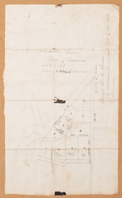
... Allan access to permanent water at Coimadai] circa 1870s...There are mentions of an Allans Road at Coimadai in the Bacchus Marsh Express between 1887 and 1942....Plan showing Excisions from Ross's selection and 1 chain road thro' the said selection in Coimadai to give J. Allan access to permanent water. ...Coimadai Victoria Maps Coimadai Roads and Streets Plan showing Excisions from Ross's selection and 1 chain road thro' the said selection in Coimadai to give J. ...The date of this map or plan is uncertain but it appears to be from the early to mid 1870s. One of the landholders identified on the plan, James Allan of Coimadai died suddenly on the 9th July, 1874 (see Bacchus Marsh Express, 11 July, 1874, page. 3). There are mentions of an Allans Road at Coimadai in the Bacchus Marsh Express between 1887 and 1942.Single page map showing an excision of land belonging to Charles Ross which was selected to construct a road to give another landholder, J. Allan access to permanent water. Scale 1 chain to 1 inch. Part of a set of maps which are pasted into a bound volume containing 76 maps or plans in total. High resolution digital image stored on BMDHS computer network. Plan showing Excisions from Ross's selection and 1 chain road thro' the said selection in Coimadai to give J. Allan access to permanent water. Alistair ?? Shire Eng? 6?/5/7?coimadai victoria maps, coimadai roads and streets -
 Bacchus Marsh & District Historical Society
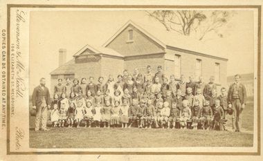
Photograph, Coimadai State School teachers and students 1883
... Coimadai State School teachers and students 1883...Coimadai is a rural community located 10km north of Bacchus Marsh. ...The image is a large group portrait of the pupils of the Coimadai State School and their two male teachers. ...Bacchus Marsh & District Historical Society Lerderderg Library Main Street Bacchus Marsh Coimadai is a rural community located 10km north of Bacchus Marsh. ...Coimadai is a rural community located 10km north of Bacchus Marsh. The Coimadai School was opened in 1862. It was at first entirely funded by the local residents in the area. In these early years it was known as the Pyrete School after the nearby creek of that name. The building shown in this 1883 image was constructed in 1872 and replaced an earlier wooden structure. Over time the Coimadai School became a government funded and administered school. A famous pupil to attend the school was John Cain Senior, Premier of Victoria in the 1940s and 1950s, who attended the school for one year in 1893. This school still operates as a state primary school.Small sepia unframed photograph on card with gold border framing photograph. Housed in the album, 'Photographs of Bacchus Marsh and District in 1883 by Stevenson and McNicoll'. The image is a large group portrait of the pupils of the Coimadai State School and their two male teachers. There are about 60 pupils. The older children are standing in rows and a younger group of pupils is seated on forms or benches in front of them. One teacher stands on the right of the group of pupils and the other is on the left. The School building can be seen in the background.On the front: Stevenson & McNicoll. Photo. 108 Elizabeth St. Melbourne. COPIES CAN BE OBTAINED AT ANY TIME. On the back: LIGHT & TRUTH inscribed on a banner surmounted by a representation of the rising sun. Copies of this Portrait can be had at any time by sending the Name and Post Office Money Order or Stamps for the amount of order to STEVENSON & McNICOLL LATE BENSON & STEVENSON, Photographers. 108 Elizabeth Street, MELBOURNE schools, schools coimadai vic., stevenson and mcnicoll 1883 photographs of bacchus marsh and district -
 Bacchus Marsh & District Historical Society
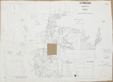
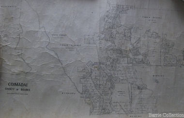
Map, Coimadai Parish Map, County of Bourke. Circa 1890s-1900s
... Coimadai Parish Map, County of Bourke. Circa 1890s-1900s....The cadastral Parish of Coimadai, a subdivision of the County of Bourke, lies directly north of the township of Bacchus Marsh. ...A single page paper map showing the map for the Parish of Coimadai in the County of Bourke. A cadastral map showing parish boundaries and land ownership. ...Bacchus Marsh Region Parish Plans Coimadai Parish Maps Coimadai Parish Plan Photo-lithographed at the Department of Lands and Survey, Melbourne by T.F. ...The cadastral Parish of Coimadai, a subdivision of the County of Bourke, lies directly north of the township of Bacchus Marsh. The date of this map is uncertain. T.F. McGauran the person who made a photo-lithographic copy of the map was in charge of photo-lithography at the Victorian Department of Lands and Survey in the late 19th century until about 1910.A single page paper map showing the map for the Parish of Coimadai in the County of Bourke. A cadastral map showing parish boundaries and land ownership. A rectangle shaped area is missing from the centre of the map due to a tear or deliberate excision. The map is pasted into a bound volume containing 76 maps or plans in total. High resolution digital image stored on BMDHS computer network. Photo-lithographed at the Department of Lands and Survey, Melbourne by T.F. McGauran 26.8.[??] NOTE. Photo litho from L.P showing temporary surveys and occupation of land prepared for departmental use onlybacchus marsh region parish plans, coimadai parish maps, coimadai parish plan -
 Bacchus Marsh & District Historical Society
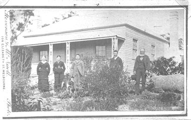
Photograph, Jeffrey family and farmhouse Coimadai 1883
... Jeffrey family and farmhouse Coimadai 1883...This photograph is believed to be of the farm "Glencairn" at Coimadai near Bacchus Marsh. The family includes Mrs Alice Jeffrey (nee Dickson), Mr. ...This photograph is believed to be of the farm "Glencairn" at Coimadai near Bacchus Marsh. The family includes Mrs Alice Jeffrey (nee Dickson), Mr. ...This photograph is believed to be of the farm "Glencairn" at Coimadai near Bacchus Marsh. The family includes Mrs Alice Jeffrey (nee Dickson), Mr. William Jeffrey, daughter Annie and two sons. Mr William Jeffrey died at "Glencairn", Coimadai, in 1906, at the age of 80. His homestead and farm were known as a model of neatness and planning. The sheep held by Mr. Jeffrey appears to be a Lincoln Long- woolled sheep. The unusual lead, which has a handle, suggests that this sheep was often exhibited at Agricultural Shows and may have won prizes in its class. Mr Jeffrey was a frequent exhibitor and prize-winner at the Bacchus Marsh Agricultural Society.Small photographic copy of an original Carte de Visite picture. Housed in the album, 'Photographs of Bacchus Marsh and District in 1883 by Stevenson and McNicoll'. The image shows a family group. They are standing in the garden in front of a farm house. The group comprises two women and three men. The older man on the right of the picture is believed to be William Jeffrey who is holding a sheep on a lead with a handle. A dog stands in front of a younger man in the centre of the picture. In the background is the weatherboard farm house, a simple construction with two large chimneys and a skillion extension.On the front: Stevenson & McNicoll. Photo. 108 Elizabeth St. Melbourne. COPIES CAN BE OBTAINED AT ANY TIME. On the back: LIGHT & TRUTH inscribed on a banner surmounted by a representation of the rising sun. Copies of this Portrait can be had at any time by sending the Name and Post Office Money Order or Stamps for the amount of order to STEVENSON & McNICOLL LATE BENSON & STEVENSON, Photographers. 108 Elizabeth Street, MELBOURNE. N.B. The above inscription would have appeared on the original of this photo.stevenson and mcnicoll 1883 photographs of bacchus marsh and district, farmers, jeffrey family, glencairn, farms, long woolled sheep -
 Bacchus Marsh & District Historical Society
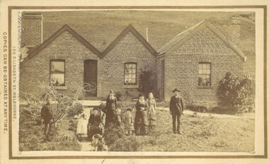
Photograph, Burnip Family and House Coimadai 1883
... Burnip Family and House Coimadai 1883...Sometime after this he came to the Bacchus Marsh area and purchased a farm near Coimadai and named it 'The Pines'. George Burnip was active in public affairs as a member of School Board of Advice and the Agricultural Society. ...Burnip Family and House Coimadai 1883 Photograph ...The family group in this image is the Burnip family. George Burnip came to Australia in 1854. In 1856 he married Julia Grant. Sometime after this he came to the Bacchus Marsh area and purchased a farm near Coimadai and named it 'The Pines'. George Burnip was active in public affairs as a member of School Board of Advice and the Agricultural Society. One of the two men in this image is likely to be George Burnip, probably the man on the left. The man standing on the right is possibly his son, John, who would have been 22 at the time this photo was taken. The woman seated on a chair placed on the pathway is probably Mrs Julia Burnip. The woman standing with her arms crossed is possibly Mrs Julia Carroll (nee Burnip). The children pictured are likely to be the five Burnip children and two others.Small sepia unframed photograph on card with gold border framing photograph. Housed in the album, 'Photographs of Bacchus Marsh and District in 1883 by Stevenson and McNicoll'. An image showing a brick house with a pitched roof in three separate sections. Two chimneys on either side of the house can be seen. Standing in front of the house is a group of people, male and female, young and old. One female is older and is seated in a chair. At the front of the group is a dog.On the front: Stevenson & McNicoll. Photo. 108 Elizabeth St. Melbourne. COPIES CAN BE OBTAINED AT ANY TIME. On the back: LIGHT & TRUTH inscribed on a banner surmounted by a representation of the rising sun. Copies of this Portrait can be had at any time by sending the Name and Post Office Money Order or Stamps for the amount of order to STEVENSON & McNICOLL LATE BENSON & STEVENSON, Photographers. 108 Elizabeth Street, MELBOURNE houses coimadai vic, stevenson and mcnicoll 1883 photographs of bacchus marsh and district, houses bacchus marsh, burnip family bacchus marsh -
 Melton City Libraries
Map, Coimadai County of Bourke, 1911
... Coimadai County of Bourke...Melton City Libraries 31 McKenzie Street Melton melbourne Council Town Plan of Melton Coimadai County of Bourke Map Barrie Collection ...Town Plan of Meltoncouncil -
 Bacchus Marsh & District Historical Society
Map, Limestone Reserve Parish of Merrimu 1888
... Limestone deposits in the Coimadai area 10 kilometers north of Ballarat were first worked in the 1850s. ...Single page map showing part of the Limestone reserve near Coimadai in the Parish of Merrimu. Scale 4 chains to 1 inch. ...The Alkemade family were involved in the limestone industry over several generations at Coimadai. Bacchus Marsh Victoria Maps Lime kilns Coimadai Limestone Coimadai Victoria Maps Alkemade Family Coimadai Copy of plan surveyed by Mr. ...Limestone deposits in the Coimadai area 10 kilometers north of Ballarat were first worked in the 1850s. The area was quarried for limestone for many years by various people and companies. The surveyor's name who produced this plan is inscribed on the map and below this is the name P. L. Alkemade, who presumably paid for the map to be produced. In 1886 Petrus Alkemade in partnership with Matthew Egan established the Alkemade Hydraulic Lime and Cement Company. The Alkemade family were involved in the limestone industry over several generations at Coimadai.Single page map showing part of the Limestone reserve near Coimadai in the Parish of Merrimu. Scale 4 chains to 1 inch. Part of a set of maps which are pasted into a bound volume containing 76 maps or plans in total. High resolution digital image stored on BMDHS computer network. Copy of plan surveyed by Mr. G? [illegible] an authorised surveyor on 17th July 1888. P. L. Alkemadebacchus marsh victoria maps, lime kilns coimadai, limestone, coimadai victoria maps, alkemade family coimadai -
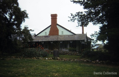
 Melton City Libraries
Photograph, "Green Hills" Borbidge, 1978
... Estate in Diggers Rest Coimadai Road, Toolern Vale...Local Architecture Pioneer Families Estate in Diggers Rest Coimadai Road, Toolern Vale "Green Hills" Borbidge Photograph Barrie Collection ...Built by Water Browne c.1903 Greenhills was one of the first pastoral runs, and centres of European settlement, established in the Shire of Melton. Estate in Diggers Rest Coimadai Road, Toolern Valelocal architecture, pioneer families -
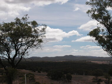 Ballarat Heritage Services
Photograph - Photograph - Colour, Coimodai near Bacchus Marsh, 2007, 04/03/2007
... A number of photos taken to create a 360 degree view of Coimadai...Ballarat Heritage Services PO Box 2209 Bakery Hill Post Office goldfields Coimodai is in the vicinity of Bacchus Marsh, Victoria coimodai farmland landscape A number of photos taken to create a 360 degree view of Coimadai Coimodai near Bacchus Marsh, 2007 Photograph Photograph - Colour Clare Gervasoni ...Coimodai is in the vicinity of Bacchus Marsh, VictoriaA number of photos taken to create a 360 degree view of Coimadaicoimodai, farmland, landscape -
 Melton City Libraries
Photograph, Gnotuk Park, 1970
... Farm house located at 2389-2485, Diggers Rest-Coimadai Road, Diggers Rest. ...Melton Heritage Study Stage 2 Volume 3 Local Architecture Local Identities Farm house located at 2389-2485, Diggers Rest-Coimadai Road, Diggers Rest. Gnotuk Park Photograph Barrie Collection ...Built in 1897, "it is one of the best-known of the Melton farm properties established in the historic break-up of the large pastoral estates at the turn of the twentieth century". Melton Heritage Study Stage 2 Volume 3Farm house located at 2389-2485, Diggers Rest-Coimadai Road, Diggers Rest. local architecture, local identities -
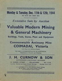 Bendigo Historical Society Inc.
Document - IAN DYETT COLLECTION: AUCTION CATALOGUE - COMMONWEALTH ANTIMONY MINE
... Two blue covered with dark blue printing for an auction sale held on the 11th and 12th December, 1944 at the Commonwealth Antimony Mine at Coimadai, near Bacchus Marsh, Vic. Of Modern Mining & General Machinery, Buildings, Tools, Stores, Plant & Equipment by Order of Commonwealth of Australia, Department of Supply and Shipping. ...History House 11 Mackenzie Street Bendigo goldfields BUSINESS Auctioneers j h curnow & son pty ltd Ian Dyett Collection - Auction Catalogue - Commonwealth Antimony Mine J H Curnow & Son J L Jamieson & Co W G Wedd Prahran Telegraph Print Two blue covered with dark blue printing for an auction sale held on the 11th and 12th December, 1944 at the Commonwealth Antimony Mine at Coimadai, near Bacchus Marsh, Vic. Of Modern Mining & General Machinery, Buildings, Tools, Stores, Plant & Equipment by Order of Commonwealth of Australia, Department of Supply and Shipping. ...Two blue covered with dark blue printing for an auction sale held on the 11th and 12th December, 1944 at the Commonwealth Antimony Mine at Coimadai, near Bacchus Marsh, Vic. Of Modern Mining & General Machinery, Buildings, Tools, Stores, Plant & Equipment by Order of Commonwealth of Australia, Department of Supply and Shipping. Sale conducted by permission of the Director of Machine Tools and Gauges under Regulation 59 of the National Security (General) Regulations. J. H. Curnow & Son ere the auctioneers.business, auctioneers, j h curnow & son pty ltd, ian dyett collection - auction catalogue - commonwealth antimony mine, j h curnow & son, j l jamieson & co, w g wedd, prahran telegraph print -
![Map, Liquidator's sale, 1896. [Woolpack Estate, Bacchus Marsh]](/media/collectors/5e461d8021ea67224c82f2a1/items/6779ee97032b72846b5995f2/item-media/6779ef33032b72846b599b30/item-fit-380x285.jpg?cb=6) Bacchus Marsh & District Historical Society
Bacchus Marsh & District Historical SocietyMap, Liquidator's sale, 1896. [Woolpack Estate, Bacchus Marsh]
... Also shown on the map are lots for sale at Robinson's Farm on Coimadai Creek and allotments near Bacchus Marsh railway station, including lots on Government Road (East Maddingley Road), View Street and Government Road (Parwan Road). ...Also shown on the map are lots for sale at Robinson's Farm on Coimadai Creek and allotments near Bacchus Marsh railway station, including lots on Government Road (East Maddingley Road), View Street and Government Road (Parwan Road). ...The Woolpack Estate was an area of land owned by various landowners in the Bacchus Marsh area since the early Colonial period of the 1840s. The area was located on the eastern side of the Bacchus Marsh township about 7 kilometers from the town. The Lerderderg River ran through part of the land and so did the Melbourne to Ballarat Road. The historic Woolpack Inn associated with James Crook was also located on this land. By 1896 150 acres of this land was under the control of liquidators for the Federal Bank of Australasia who instructed that the land be sub-divided and sold in lots by public auction. A successful sale was held on 24 June 1896. Most of the blocks of land were sold for higher than expected prices and most of the buyers were people from the town and district of Bacchus Marsh. The map includes various details about the land which is described on the map as an "important sale of rich alluvial irrigable flat land in the Bacchus Marsh Valley, and other properties". The auction was conducted by the local agents W. Anderson and Bence in conjunction with Pearce Brothers also of Bacchus Marsh.A single page paper map showing a plan of 150 acres of land from the Woolpack Estate to be sold in various lots in June 1896. Also shown on the map are lots for sale at Robinson's Farm on Coimadai Creek and allotments near Bacchus Marsh railway station, including lots on Government Road (East Maddingley Road), View Street and Government Road (Parwan Road). No scale provided. The map is pasted into a bound volume containing 76 maps or plans in total. High resolution digital image stored on BMDHS computer network. land sales bacchus marsh, bacchus marsh victoria maps, woolpack estate bacchus marsh victoria -
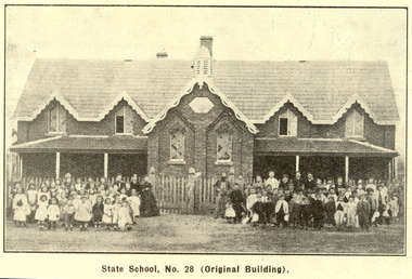 Federation University Historical Collection
Booklet, Back to Bacchus Marsh, 1930, 1930
... ...coimadai...Contents include Bacchus Marsh and its soldiers, Red Cross, Lerderderg Gorge, Werribee Gorge, Lerderderg Park, Coimadai, Darely Firebrick Co., Myrniong, Underbank, Balliang, Rowsley, Parwan, schoosl, churches, Shire Council, Federal Milk Pty Ltd, Bacchus Marsh Milk, Old Maddingley Bridge Images include: * Bacchus Marsh looking east, 1930 * Bacchus Marsh Looking West, 1872 * Bacchus Marsh Looking West, 1930 * Aerial View of Bacchus Marsh Township looking east * Aerial View of Bacchus Marsh Township looking south * Bacchus Marsh Agricultural Society & Pastoral Society, 1893 (named), * Original Bacchus Marsh State School No 28 * Holy Trinity Bacchus Marsh * Bacchus Marsh Baptist Church * St Bernard's Catholic Church * Bacchus Marsh Methodist Church * St Andrew's Presbyterian Church Bacchus Marsh * View of Maddingley Park, showing Original Courthouse, 1890 * Werribee Gorge * Underbank Stud Farm * Ballarat State School Number 28. ...(Back to Bacchus Marsh, 1930) bacchus marsh maddingley maddingley park underbank lerderderg park coimadai darely firebrick co. myrniong balliang rowsley parwan schoosl churches shire council federal milk pty ltd bacchus marsh milk old maddingley bridge police police paddock maddingley gates crisp mccormack cain harkness howe bence mcdonald mcfarlane cosgrave flagg burnip scott lodge cameron vallance bacchus marsh state school bacchus marsh state school no 28. geology r.w. thompson lederderg gorge weribee gorge comadai darley firebrick company Signed 'C. ...The 1930 Back to Bacchus Marsh celebrations were held on 23 to 28 October 1930. The committee were Cr L.M. Gugdale (president), A.W. Bond (General secretary), W. Grant Morton, J.G. Wells, Dr E. McDonald, Charles Dickie, G.H. Anderson, F.M. Crisp, W.R. Vigor. Bacchus Marsh State School No. 28 was established in 1851 as a National School in a rented building on the right-hand side of Bacchus Marsh-Melbourne Road, just beyond Woolpack Inn. Several willow trees mark the site. H.G. Ball was the first Head Teacher of the school, and the enrolmen towas 34. In 1854 Governor Charles Hotham visited the school. In 1855 two new schools, East and West, were recommended. School No. 28 closed in 1862 and the sitre was sold. The present school site was purchased in 1865 for 67 pounds. The cost of the building was 782 pounds. (Visions and Realisations, Vol 3., 1973) A clock purchased by public subscription was placed in the front of the building to the memory of scholars who served during World War One. (Back to Bacchus Marsh, 1930)Brown covered book of 44 pages. Contents include Bacchus Marsh and its soldiers, Red Cross, Lerderderg Gorge, Werribee Gorge, Lerderderg Park, Coimadai, Darely Firebrick Co., Myrniong, Underbank, Balliang, Rowsley, Parwan, schoosl, churches, Shire Council, Federal Milk Pty Ltd, Bacchus Marsh Milk, Old Maddingley Bridge Images include: * Bacchus Marsh looking east, 1930 * Bacchus Marsh Looking West, 1872 * Bacchus Marsh Looking West, 1930 * Aerial View of Bacchus Marsh Township looking east * Aerial View of Bacchus Marsh Township looking south * Bacchus Marsh Agricultural Society & Pastoral Society, 1893 (named), * Original Bacchus Marsh State School No 28 * Holy Trinity Bacchus Marsh * Bacchus Marsh Baptist Church * St Bernard's Catholic Church * Bacchus Marsh Methodist Church * St Andrew's Presbyterian Church Bacchus Marsh * View of Maddingley Park, showing Original Courthouse, 1890 * Werribee Gorge * Underbank Stud Farm * Ballarat State School Number 28. Signed 'C. Hodgson'bacchus marsh, maddingley, maddingley park, underbank, lerderderg park, coimadai, darely firebrick co., myrniong, balliang, rowsley, parwan, schoosl, churches, shire council, federal milk pty ltd, bacchus marsh milk, old maddingley bridge, police, police paddock, maddingley gates, crisp, mccormack, cain, harkness, howe, bence, mcdonald, mcfarlane, cosgrave, flagg, burnip, scott, lodge, cameron, vallance, bacchus marsh state school, bacchus marsh state school no 28., geology, r.w. thompson, lederderg gorge, weribee gorge, comadai, darley firebrick company -
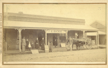 Bacchus Marsh & District Historical Society
Photograph, George Dickie Bakery 162 Main Street Bacchus Marsh 1883
... In 1863, he married Ellen Ross Anderson, and after five years of farming in Coimadai, they moved into Bacchus Marsh and established a business. ...In 1863, he married Ellen Ross Anderson, and after five years of farming in Coimadai, they moved into Bacchus Marsh and established a business. ...George Dickie arrived in the Bacchus Marsh area around 1857. In 1863, he married Ellen Ross Anderson, and after five years of farming in Coimadai, they moved into Bacchus Marsh and established a business. In 1866 he bought the bakery business which had been established by James Boatwood and later conducted by William Watson. This business was in Main Street and is shown in this image during the time it was owned and operated by George Dickie. Ellen and George Dickie had seven children, two sons and five daughters. In his later years he changed the business into a general store and also engaged in grain dealing. He died in 1904 but the business was carried on by his sons until sold in March 1916 to a Charles Medling from Numurkah. The building was later demolished in 1927 to make way for four new shops.Small sepia 'carte de viste' style unframed photograph on card with gold border framing photograph. Housed in the Jeremeas Family Album which contains photographs of Bacchus Marsh and District in 1883 by the photographers Stevenson and McNicoll. The picture shows the business of George Dickie which was located in Main Street Bacchus Marsh. The building is a brick or stone structure with a verandah along the entire frontage of the building. Standing in front of the building is a group of adults and children. On the far left is a man wearing a dress coat and hat. He is possibly Mr. George Dickie the owner of this business. To his left are some younger and older children, and a woman, possibly Mrs DIckie. In the background in the doorway is a young boy with woman behind him. On the right of the picture on the street is a man standing alongside a horse and cart. Some advertising signs are leaning against the shop, footpath and verandah pillar. One of them says 'Chaff, Oats, Bran'. Printed On the front: Stevenson & McNicoll. Photo. 108 Elizabeth St. Melbourne. COPIES CAN BE OBTAINED AT ANY TIME. On the back: LIGHT & TRUTH inscribed on a banner surmounted by a representation of the rising sun. Copies of this Portrait can be had at any time by sending the Name and Post Office Money Order or Stamps for the amount of order to STEVENSON & McNICOLL LATE BENSON & STEVENSON, Photographers. 108 Elizabeth Street, MELBOURNE. stevenson and mcnicoll 1883 photographs of bacchus marsh and district, bakeries, shops bacchus marsh, george dickie 1831-1904, dickie family bacchus marsh