Showing 31 items matching "colbinabbin"
-
 Bendigo Historical Society Inc.
Map - COLBINABBIN, June 1951
... COLBINABBIN......Colbinabbin...Map: Colbinabbin, County of Rodney. Parish plan...Parish plan Map COLBINABBIN ...Map: Colbinabbin, County of Rodney. Parish planmap, rodney, parish plan, colbinabbin, county of rodney -
 Victorian Railway History Library
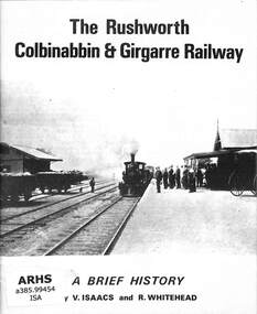
Book, Issacs, V. et al, The Rushworth Colbinabbin and Girgarre Railway, 1973
... The Rushworth Colbinabbin and Girgarre Railway...The Rushworth Colbinabbin and Girgarre Railway Book Issacs, V. ...A brief history of the Rushworth, Colbinabbin & Girgarre Railway as part of tour notes for a trip by the Australian Railway Historical Society on the 21st July 1973.ill, maps, p.23.non-fictionA brief history of the Rushworth, Colbinabbin & Girgarre Railway as part of tour notes for a trip by the Australian Railway Historical Society on the 21st July 1973.railroad construction - victoria - history, australian railway historical society - tours -
 Tatura Irrigation & Wartime Camps Museum
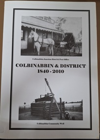
Book, Colbinabbin & District 1840-2010
... Colbinabbin & District 1840-2010...Tatura Irrigation & Wartime Camps Museum 49 Hogan Street Tatura the-murray 1840 - 2010 Colbinabbin and district History of Colbinabbin area and it's families A4 book of 164 pages Colbinabbin & District 1840-2010 Book ...History of Colbinabbin area and it's familiesA4 book of 164 pagesnon-fictionHistory of Colbinabbin area and it's familiescolbinabbin and district -
 Victorian Railway History Library
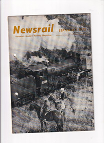
Journal - Newsrail September 1973, Unattributed, History of the Gippslander. Reports of the Colbinabbin and Girgarre tour of July 1973, 1973
... Reports of the Colbinabbin and Girgarre tour of July 1973...Gippslander Colbinabbin/Girgarre Two articles from the September 1973 issue of Newsrail. ...Two articles from the September 1973 issue of Newsrail. First - History of the Gippslander train that ran between Melbourne and Bairnsdale. Second - Report of a rail tour to Colbinabbin and Girgarre in July 1973 with R707 and K184.Ill, p.20.non-fictionTwo articles from the September 1973 issue of Newsrail. First - History of the Gippslander train that ran between Melbourne and Bairnsdale. Second - Report of a rail tour to Colbinabbin and Girgarre in July 1973 with R707 and K184.gippslander, colbinabbin/girgarre -
Tatura Irrigation & Wartime Camps Museum
Document, Waranga Conservation Study Vol. 4, 1988
... Front cover illustrates Colbinabbin Homestead, Colbinabbin 1867...Front cover illustrates Colbinabbin Homestead, Colbinabbin 1867 Waranga Conservation Study Vol. 4 Document ...Written as part of a series. Deals with Buildings and historical context in which they may be judged.White plastic back, clear front. White plastic spiral. Front cover illustrates Colbinabbin Homestead, Colbinabbin 1867burnewang house, rushworth court house, documents, reports -
Tatura Irrigation & Wartime Camps Museum
Document, G Butler, Architectoral Historian, Waranga Conservation Study 1988 Vol 4, 1988
... Front cover illustrates Colbinabbin Homestead, Colbinabbin 1867....Front cover illustrates Colbinabbin Homestead, Colbinabbin 1867. Waranga Conservation Study 1988 Vol 4 Document G Butler, Architectoral Historian ...Written as part of a series . Deals with buildings and historical context in which they may be judged. White plastic back/ clear plastic front/ white plastic spiral. Front cover illustrates Colbinabbin Homestead, Colbinabbin 1867.burnewang house -
 Bendigo Historical Society Inc.
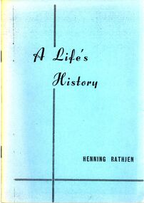
Book - STRAUCH COLLECTION: A LIFES HISTORY
... Small booklet, A Lifes's History of the late Henning Rathjen of Colbinabbin, compiled and written by Alfred E Rathjen, 15 pages with black and white photographs....History House 11 Mackenzie Street Bendigo goldfields PERSON Individual henning rathjen History-Victoria-Colbinabbin-Rathjen Alfred e Rathjen Small booklet, A Lifes's History of the late Henning Rathjen of Colbinabbin, compiled and written by Alfred E Rathjen, 15 pages with black and white photographs. ...Small booklet, A Lifes's History of the late Henning Rathjen of Colbinabbin, compiled and written by Alfred E Rathjen, 15 pages with black and white photographs.Alfred e Rathjenperson, individual, henning rathjen, history-victoria-colbinabbin-rathjen -
 Bendigo Historical Society Inc.
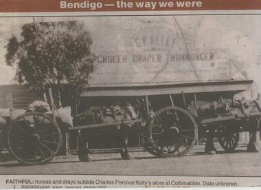
Newspaper - JENNY FOLEY COLLECTION: FAITHFUL
... Faithful: horses and drays outside Charles Percival Kelly's store at Colbinabbin. Date unknown. The clip is in a folder....Faithful: horses and drays outside Charles Percival Kelly's store at Colbinabbin. Date unknown. The clip is in a folder. ...Bendigo Advertiser ''The way we were'' from 2001. Faithful: horses and drays outside Charles Percival Kelly's store at Colbinabbin. Date unknown. The clip is in a folder.newspaper, bendigo advertiser, the way we were -
 Bendigo Historical Society Inc.
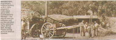
Newspaper - JENNY FOLEY COLLECTION: MAKING HAY
... Hill's property in Colbinabbin about 1915....Hill's property in Colbinabbin about 1915. Newspaper JENNY FOLEY COLLECTION: MAKING HAY ...Bendigo Advertiser "The way we were" from Saturday, September 25, 2004. Making hay: Hugh Boyd's thrasher working on W.C. Hill's property in Colbinabbin about 1915.newspaper, bendigo advertiser, the way we were -
 Bendigo Historical Society Inc.
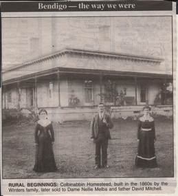
Newspaper - JENNY FOLEY COLLECTION: RURAL BEGINNINGS
... Rural beginnings: Colbinabbin Homestead, built in the 1860s by the Winters family, later sold to Dame Nellie Melba and father David Mitchell....Rural beginnings: Colbinabbin Homestead, built in the 1860s by the Winters family, later sold to Dame Nellie Melba and father David Mitchell. ...Bendigo Advertiser ''The way we were'' from 1999. Rural beginnings: Colbinabbin Homestead, built in the 1860s by the Winters family, later sold to Dame Nellie Melba and father David Mitchell.newspaper, bendigo advertiser, the way we were -
Creswick Campus Historical Collection - University of Melbourne
Map, c.1930?
... Subjects: Bendigo, Bendock, Castlemaine, Colbinabbin, Corio, Creswick, Dartmoor, Daylesford, Dunolly, Geelong, Gembrook, Glenmaggie, Juliet, Kaye, Maryborough, Murchison, Ringwood, Stratford, Walhalla...Subjects: Bendigo, Bendock, Castlemaine, Colbinabbin, Corio, Creswick, Dartmoor, Daylesford, Dunolly, Geelong, Gembrook, Glenmaggie, Juliet, Kaye, Maryborough, Murchison, Ringwood, Stratford, Walhalla School of Botany, Univerity of Melbourne Maps Map ...30 topographical maps, etc dating from 1930's. Subjects: Bendigo, Bendock, Castlemaine, Colbinabbin, Corio, Creswick, Dartmoor, Daylesford, Dunolly, Geelong, Gembrook, Glenmaggie, Juliet, Kaye, Maryborough, Murchison, Ringwood, Stratford, WalhallaMapsSchool of Botany, Univerity of Melbourne -
Bendigo Historical Society Inc.
Map - CORNELLA : COUNTY OF BENDIGO, 18-3-08
... Cornella, County of Bendigo, County of Rodney, Colbinabbin, Gobarup, Redcastle, Toolleen, Cornella Creek, Kangaroo Creek. ...Cornella, County of Bendigo, County of Rodney, Colbinabbin, Gobarup, Redcastle, Toolleen, Cornella Creek, Kangaroo Creek. ...Map. Cornella, County of Bendigo, County of Rodney, Colbinabbin, Gobarup, Redcastle, Toolleen, Cornella Creek, Kangaroo Creek. Photo-Lithographed at the Department of Lands and Survey, Melbourne by T.F. McGauran. 18-3-08. Price 1/-. (number 122 in map cupboard 1)T.F. McGauranmap, bendigo, cornella -
Bendigo Historical Society Inc.
Map - CORNELLA : COUNTY OF BENDIGO, 13-4-32
... Cornella, County of Bendigo, County of Rodney, Colbinabbin, Gobarup, Redcastle, Toolleen, Kangaroo Creek, Cornella Creek. ...Cornella, County of Bendigo, County of Rodney, Colbinabbin, Gobarup, Redcastle, Toolleen, Kangaroo Creek, Cornella Creek. ...Map. Cornella, County of Bendigo, County of Rodney, Colbinabbin, Gobarup, Redcastle, Toolleen, Kangaroo Creek, Cornella Creek. By authority H.J. Green, Govt. Printer. Photo-Lithographed at the Department of Lands and Survey, Melbourne. 13-4-32. Price 2/-. (number 123 in map cupboard 1)H.J. Green, Govt.Printermap, bendigo, cornella -
 Bendigo Historical Society Inc.
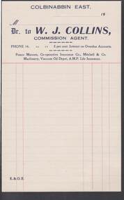
Document - CAMBRIDGE PRESS COLLECTION: ACCOUNT - W. J. COLLINS
... Collins, Commission Agent, Colbinabbin East. Agents for Fresco Manure, Co-operative Insurance Co., Mitchell & Co Machinery, Vacuum Oil Depot and A.M.P. ...Collins, Commission Agent, Colbinabbin East. Agents for Fresco Manure, Co-operative Insurance Co., Mitchell & Co Machinery, Vacuum Oil Depot and A.M.P. ...Account page from W. J. Collins, Commission Agent, Colbinabbin East. Agents for Fresco Manure, Co-operative Insurance Co., Mitchell & Co Machinery, Vacuum Oil Depot and A.M.P. Life Insurance, Date line ends 19--. Printed in dark blue with red lines.business, printers, cambridge press, cambridge press collection, w j collins, fresco manure, co-operative insurance co., mitchell & co machinery, vacuum oil depot, a.m.p. life insurance -
Bendigo Historical Society Inc.
Map - RUNNYMEDE : COUNTY OF BENDIGO, 8-12-13
... County of Bendigo, County of Rodney, Burnewang, Elmore, Nolan, Campaspe, Colbinabbin, Burramboot, Corop, Township of Runnymede, Campaspe River, Mount Pleasant Creek. ...County of Bendigo, County of Rodney, Burnewang, Elmore, Nolan, Campaspe, Colbinabbin, Burramboot, Corop, Township of Runnymede, Campaspe River, Mount Pleasant Creek. ...Map. County of Bendigo, County of Rodney, Burnewang, Elmore, Nolan, Campaspe, Colbinabbin, Burramboot, Corop, Township of Runnymede, Campaspe River, Mount Pleasant Creek. Photo-Lithographed at the Department of Lands and Survey, Melbourne by W.J. Butson.8-12-13. Price 1/-. (number 107 in map cupboard 1)W.J. Butsonmap, bendigo, runnymede -
Bendigo Historical Society Inc.
Map - TOOLLEEN : COUNTY OF BENDIGO, 25-5-26
... Toolleen, County of Bendigo, County of Rodney, Campaspe, Colbinabbin, Cornella, Crosbie, Muskerry, Mount Pleasant Creek, Township of Toolleen. ...Toolleen, County of Bendigo, County of Rodney, Campaspe, Colbinabbin, Cornella, Crosbie, Muskerry, Mount Pleasant Creek, Township of Toolleen. ...Map. Toolleen, County of Bendigo, County of Rodney, Campaspe, Colbinabbin, Cornella, Crosbie, Muskerry, Mount Pleasant Creek, Township of Toolleen. By authority H.J. Green, Govt. Printer. Photo-Lithographed at the Department of Lands and Survey, Melbourne by W.J. Butson, 25-5-26. (number 106 in map cupboard 1)H.J. Green, Govt. Printermap, bendigo, toolleen -
Bendigo Historical Society Inc.
Map - TOOLLEEN : COUNTY OF BENDIGO, 25-5-26
... Toolleen, County of Bendigo, County of Rodney, Campaspe, Colbinabbin, Cornella, Crosbie, Muskerry, Mount Pleasant Creek, Township of Toolleen. ...Toolleen, County of Bendigo, County of Rodney, Campaspe, Colbinabbin, Cornella, Crosbie, Muskerry, Mount Pleasant Creek, Township of Toolleen. ...Map. Toolleen, County of Bendigo, County of Rodney, Campaspe, Colbinabbin, Cornella, Crosbie, Muskerry, Mount Pleasant Creek, Township of Toolleen. By authority H.J. Green, Govt. Printer. Photo-Lithographed at the Department of Lands and Survey, Melbourne by W.J. Butson, 25-5-26. (number 105 in map cupboard 1)H.J. Green, Govt. Printer.map, bendigo, toolleen -
Bendigo Historical Society Inc.
Map - EPPALOCK : COUNTY OF BENDIGO, 1982
... Eppalock, County of Bendigo, Axedale, Knowsley, Heathcote, Tooborac, Kyneton, Lancefield, Pyalong, Seymour, Graytown, Toolleen, Colbinabbin, Costerfield, Redesdale, Mia Mia, Nagambie, Department of Interior, Puckapunyal Military Area, Various connecting roads. ...Eppalock, County of Bendigo, Axedale, Knowsley, Heathcote, Tooborac, Kyneton, Lancefield, Pyalong, Seymour, Graytown, Toolleen, Colbinabbin, Costerfield, Redesdale, Mia Mia, Nagambie, Department of Interior, Puckapunyal Military Area, Various connecting roads. ...Map. Eppalock, County of Bendigo, Axedale, Knowsley, Heathcote, Tooborac, Kyneton, Lancefield, Pyalong, Seymour, Graytown, Toolleen, Colbinabbin, Costerfield, Redesdale, Mia Mia, Nagambie, Department of Interior, Puckapunyal Military Area, Various connecting roads. Shire of McIvor. Updated Dec.1982. (number 40 in map cupboard 1)map, bendigo, eppalock -
Bendigo Historical Society Inc.
Map - CAMPASPE : COUNTY OF BENDIGO, 1964
... Campaspe, County of Bendigo, County of Rodney, Runnymede, Nolan, Muskerry, Toolleen, Colbinabbin, Campaspe River, Goornong, Mount Pleasant Creek. ...Campaspe, County of Bendigo, County of Rodney, Runnymede, Nolan, Muskerry, Toolleen, Colbinabbin, Campaspe River, Goornong, Mount Pleasant Creek. ...Map. Campaspe, County of Bendigo, County of Rodney, Runnymede, Nolan, Muskerry, Toolleen, Colbinabbin, Campaspe River, Goornong, Mount Pleasant Creek. By authority A.C. Brooks, Government Printer, Melbourne. Drawn and reproduced at the Department of Lands and Survey, Melbourne. 1964. Price 10/- per sheet. (number 112 in map cupboard 1)A.C. Brooks, Government Printer, Melbourne.map, bendigo, campaspe -
 Bendigo Military Museum
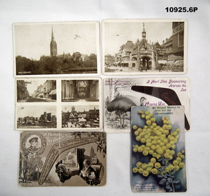
Postcard - PHOTOGRAPHIC POSTCARDS, WW1, c. 1914-18
... Address for received: Mrs J.J. Boldiston, Colbinabbin, Victoria, Aust. Colbinabbin is crossed out - written in green pencil is Junortoun P.O. via Bendigo. 3. ...Address for received: Mrs J.J. Boldiston, Colbinabbin, Victoria, Aust. Colbinabbin is crossed out - written in green pencil is Junortoun P.O. via Bendigo. 3. ...Refers to the service of "Albert Boldiston" See Cat 747 and 10924.1. Black and white image of Salisbury Cathedral. A pond in the foreground. 2. Black and white image of Salisbury town. On back in green ink is printed "Souvenir of Salisbury". There is a red 1 penny stamp. 3. Bifold postcard. One side has an image of a bridge and a building with a clocktower. Tghe otgher side has 4 smaller images of Sailsbury buildings. When opened up the word 'Salisbury' is printed in green ink. 4. Postcard front has an image of an Emu and a Boomerang. There is a poem at bottom centre, titled "Hoping you will come back to me'. 5. A postcard with drawings of a soldier, Aussie bushland, an elderley couple and a boomerang. In the boomerang is a little nostalgic poem. 6. Postcard. Painted on front is an image of some wattle flowers. Bottom left corner has a small poem. Subject is Christmas tide. 1. Someone has pencilled in a biplane. On rear St Leonards Private Hospital, Don Street. 2. Someone has drawn a small image of a kid on a bike. Address for received: Mrs J.J. Boldiston, Colbinabbin, Victoria, Aust. Colbinabbin is crossed out - written in green pencil is Junortoun P.O. via Bendigo. 3. Someone has drawn on photos - a small biplane. this is a letter to his mother. 6 lines. 4. Printed on back in light brown ink is the Manufacturers detail. 5. Written on back is a letter addressed to "Dear Bert" from J. Boldiston, 4 lines. Address Junortoun via Bendigo 23/7/18. 6. Written on the back is a letter addressed to "Dear Bert". It's from his aunt. 7 lines, senders address was Stoney Green. 5/9/18. postcards, ww1, albert boldiston, christmas -
 Bendigo Historical Society Inc.
Legal record - Ledger of Reports of Land Sales by Auction
... Ledger of Land Sales Reports 1915 sample reports of Colbinabbin, Kyabram & Rochester....Ledger of Land Sales Reports 1915 sample reports of Colbinabbin, Kyabram & Rochester. Legal record Ledger of Reports of Land Sales by Auction ...Blue and light brown ledger of land sales reports during 1898 to 1924. Blue water marked cover with light brown spine and corners, with red label on spine noting "12". Contains Crown Lands sales by auction documents, including purchasers' names, land section, allotment numbers and price. Ledger of Land Sales Reports 1915 sample reports of Colbinabbin, Kyabram & Rochester.land sales, auction -
 Bendigo Historical Society Inc.
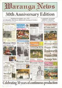
Document - WARANGA NEWS 30TH ANNIVERSARY EDITION SUPPLEMENT 18 SEPTEMBER 2008, 18th September, 2008
... Published fortnightly since 1978 in Colbinabbin, Murchison, Rushworth, Stanhope and Toolleen. ...Published fortnightly since 1978 in Colbinabbin, Murchison, Rushworth, Stanhope and Toolleen. ...Waranga News 30th Anniversary Edition Voluntary Community Newspaper. Published fortnightly since 1978 in Colbinabbin, Murchison, Rushworth, Stanhope and Toolleen. Office Staff of 2008: Owen Doyle, Len Schoenborn, Colleen Wright, Brian Wright, Rosemary Hawking, Neil Short, Gillian Schoenborn, Graeme Harwood, Bob Holschier, Glen Avard, Denise Corbin, Peter Burgess, Jeanette Paterson, Mary Jo Fortuna, Doris Barlow, Floss Holschier. Behind the camera Cass Alexander.Waranga Newsvictoria, history, community newspaper waranga basin -
 Bendigo Military Museum
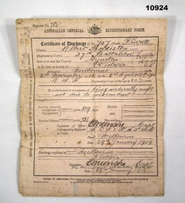
Certificate - DISCHARGE CERTIFICATE WW1, Aust Army, 1919
... His application to enlist shows Colbinabbin....His application to enlist shows Colbinabbin. Certificate of Discharge WW1 Albert Boldiston Certificate is a heavy duty paper document. ...Refers to the service of: - Albert Boldiston Cat 747. Place of birth: Kyneton, Vic. Date of Entry: 2/11/16, Age 24 - Unit ANZAC Cyclist BA Embark for England: 16/12/16, Transfer to 8 Batt: 7/3/17, Embark for France: 14/6/17, Transfer to 37 Bn: 1/7/17, Hospital - sprained ankle: 5/7/17, Rejoin Unit: 7/9/17, Hospital - Trench foot: 18/11/17, Rejoin Unit: 5/6/18, WIA - GSW left wrist: 10/8/18, RTA Wounded: 20/10/18, Medically unfit due to wounded wrist joint: 29/1/19. His discharge certificate and Vic BDM's show POB as Kyneton. His application to enlist shows Colbinabbin.Certificate is a heavy duty paper document. Printed in black ink and printed on both sides. Titled "Australian Imperial Expeditionary Force", "Certificate of Discharge". There is printing up the left hand side and a stamp showing silver badge No.50671 dated 10/1/19. Rear side is stamped V/B No. 30043. 41324. Description of soldier.certificate of discharge, ww1, albert boldiston -
 Bendigo Historical Society Inc.
Document - LYDIA CHANCELLOR COLLECTION; CORRESPONDENCE, NEWSPAPER CLIPPINGS
... ' - (i) A handwritten letter to Mrs Chancellor from Nancy ? From Box 3 Colbinabbin dated 1-11-73 telling of family activities. ....' - (i) A handwritten letter to Mrs Chancellor from Nancy ? From Box 3 Colbinabbin dated 1-11-73 telling of family activities. ...A fading crimson envelope containing items of interest. The envelope is addressed to, ' Mrs L. Chancellor, Room 22, Bethlehem.' - (i) A handwritten letter to Mrs Chancellor from Nancy ? From Box 3 Colbinabbin dated 1-11-73 telling of family activities. (ii) A handwritten letter on pink writing paper from Mrs Janice McGowan, 3 Churchill Ave., Flora Hill, Bendigo. It appears she is asking Lydia for information on some possessions of hers so she can value them. Lydia has written on the top of the letter, ' ans. & posted it 18/4/75.' (iii) some handwritten lists on note paper with pictures of roses on it.ephemera, mementoes, correspondence, lydia chancellor, collection, correspondence, death notice, ephemera, personal effects, communication -
Glen Eira Historical Society
Article - Long Street, 7, Elsternwick
... ... Colbinabbin...Elsternwick Long Street Advertisements Victorian Style Land sales Houses Glenhuntly Road Colbinabbin Bay windows Rogers Mark Real estate agents Article Long Street, 7, Elsternwick ...A real estate advertisement dated 28/09/2005, source unknown regarding the sale of 7 Long Street, Elsternwick. The advertisement by real estate agent Mark Rogers includes a description of the house and a copy of a colour photograph of the exterior of the house.elsternwick, long street, advertisements, victorian style, land sales, houses, glenhuntly road, colbinabbin, bay windows, rogers mark, real estate agents -
 Bendigo Historical Society Inc.
Document - CONNELLY, TATCHELL, DUNLOP COLLECTION: LEGAL PAPERS, 1887 to 1899
... (iii) 1899 - Account to T Phillips Esq - Executor of the Estate of T Tatchell deceased for costs. 4 - Envelope marked Mr W Bockholt Farmer Colbinabbin 1899. Account to Mr W Bockholt for costs. 5 - 1887 - 1889 - Cheque payments paid into the Bank of Victoria. ...(iii) 1899 - Account to T Phillips Esq - Executor of the Estate of T Tatchell deceased for costs. 4 - Envelope marked Mr W Bockholt Farmer Colbinabbin 1899. Account to Mr W Bockholt for costs. 5 - 1887 - 1889 - Cheque payments paid into the Bank of Victoria. ...Document. Various legal documents. 1 - 1899 - Letter in envelope marked Travers Mrs. Account from Connelly, Tatchell & Dunlop to Mrs Travers (Toorak) Re costs Lowndes. 2 - 1898 - Envelope marked Mrs M A Rosel (Leitchville). Account from Connelly, Tatchell & Dunlop Solicitors to Mrs M A Rosel for costs. 3 - Envelope marked Messrs Phillips & Tatchell. (i) 1897 - Account to Messrs Phillips & Tatchell - Executors of the Will of Thomas Tatchell, deceased for costs. (ii) Contains also the Estate of Thomas Tatchell. (iii) 1899 - Account to T Phillips Esq - Executor of the Estate of T Tatchell deceased for costs. 4 - Envelope marked Mr W Bockholt Farmer Colbinabbin 1899. Account to Mr W Bockholt for costs. 5 - 1887 - 1889 - Cheque payments paid into the Bank of Victoria. Paid to Thomas Jefferson Connelly by Curnow J, Holiday C, Frost William T, Dunlop George.cottage, miners, connelly, tatchell & dunlop, mrs travers, lowndes, mrs m a rosel, phillips & tatchell, tatchell thomas, buckholt mr w, bank of victoria, connelly thomas jefferson, curnow j, holliday c, frost william t, dunlop george -
 Ballarat Heritage Services
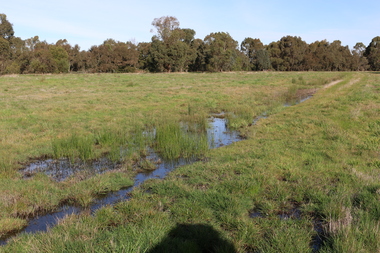
Photograph - Digital photograph, Winter's Swamp surrounds, April 2014
... He took up the run Bonshaw from 1841; Leigh River Buninyong 1842-46; Junction, Delatite, March 1851 to September 1862; with sons: Carag Carag and Corop, April 1857 to September 1872; Colbinabbin and Stewart’s Plains, April 1857 to December 1872; St Germains February 1867 to March 1871. ...He took up the run Bonshaw from 1841; Leigh River Buninyong 1842-46; Junction, Delatite, March 1851 to September 1862; with sons: Carag Carag and Corop, April 1857 to September 1872; Colbinabbin and Stewart’s Plains, April 1857 to December 1872; St Germains February 1867 to March 1871. ...The swamp was named after John (Jock) Winter. John Winter (Jock) was born in Berwickshire, Scotland. He married Janet Margaret Irving the daughter of Robert Irving, advocate, Bonshaw, Dumfries, Scotland. Winter died in Ballarat in 1875 and was buried at the Ballaarat Old Cemetery. He took up the run Bonshaw from 1841; Leigh River Buninyong 1842-46; Junction, Delatite, March 1851 to September 1862; with sons: Carag Carag and Corop, April 1857 to September 1872; Colbinabbin and Stewart’s Plains, April 1857 to December 1872; St Germains February 1867 to March 1871. (The name became Winter-Irving in 1890). Mr John Winter, who died on August 22 at the age of 72, was a man of some note it the mining community of Ballarat. He was a self-made man, and one of our oldest colonists, it being over a quarter of a century age since he took up county about Ballarat and settled at Bonshaw. He died very rich. It is calculated that if he had retained an interest in all his runs, his income must have been not less than £10,000 or £50,000 a year. Some eight or ten years ago he sold his Bonshaw pre-emption to the Bonshaw Gold mining Company for £20,000, and a few years later the ground belonging now to Winter's Freehold Company brought him £50,000 more, the payment being made at the requisition of the deceased in sovereigns. In these relations Mr. Winter has been closely identified with the mining industry at Ballarat. The deceased was a native of Lauder, in Berwickshire, and landed in Victoria several years before the gold discovery. BHS were commissioned by Ballarat Environment Network for a project on Winter's Swamp and Skipton Common. Winter's Swamp was part of Ballarat West Common. The principle task of this project was the delivery of a report outlining the history of European settlement in the Skipton and Cardigan/Ballarat districts as pertinent to the use of and impact on the natural environment of the two reserves Skipton Common and Winter Swamp. The report was delivered in digital form only. The report, upon completion, was presented to the Network’s Committee in order to discuss the project. The report identified and described the uses of Skipton Common and Winter Swamp, and their impacts. In particular, this report examined farming/grazing (official and informal), mining, vegetation removal (including the removal of woodlands for timber, grasslands for pasture improvement) & use of riparian areas for access to water and timber removal. Recording the more benign and environmentally friendly uses such as picnicking, community activities, nature walks and the roles of organisations such as Field Naturalists’ and Bird Observers’ clubs, school and scout/guide groups will be relevant in helping to depict overall community attitudes towards the reserves; e.g.: has the Common generally been viewed as little more than a grazing paddock and fire hazard; has Winter Swamp always been the unknown natural asset that seems to have been its lot for at least the past 40 years? In this regard, the more contemporary history of actions surrounding the use and management of the reserves is of particular interest, in view of the extant evidence at both reserves; e.g. the actions of the Shire of Ballarat in the 1980s in establishing Winter Swamp as something of a competitor to Lake Wendouree but with a more environmental bent (although almost none of the plants used are indigenous species, but that is part of the story); the trotting track constructed on Skipton Common in the 1960s following representations to Premier Henry Bolte and the cropping of the western section of the Common to raise funds for the town’s new swimming pool, the fertilizing of the land putting an end to the native grassland vegetation. There are obviously multiple sources of information to source in preparing the report, however sources that the contractor is specifically requested to consult are the Skipton Historical Society, the former Skipton Common managers (specifically Graeme Pett), the Cardigan Windermere Landcare Group and the Learmonth Historical Society (believed to hold many of the former Shire of Ballarat’s records pertaining to the Council’s role as the Committee of Management for both Winter Swamp and the Ballarat West Town Common – Winter Swamp was split between 2 separate Crown Land tenures). The contractor is also encouraged but not required to utilise community newsletters, such as the Skipton Community Newsletter, to publicise and seek information about the project. Skipton Historical Society (Mary Bradshaw) contacted on Thursday 12 June 2.30pm. Mary lived on a farm out of Skipton but is currently living in the township. She remembers walking along the creek of the Common especially in spring and autumn in bare feet and that it was a very pretty place. There were a few snakes around the waterway in summer. People put cows and a couple of horses on the commonage to graze. Graeme Pett has always lived close to the Common and would know a lot about it. Other possible contacts would be Nicole Petress, Secretary of the Progress Association, and the Corangamite Council, Camperdown. Mary can’t remember any photos in the Skipton Historical Society that pertain to the Common. Digital photos of Winter's swamp surrounds, later known as Mullawullah.winter, winter's swamp surrounds, winter's swap, john winter, ballarat environmental network, ballarat, mullawullah -
 Ballarat Heritage Services
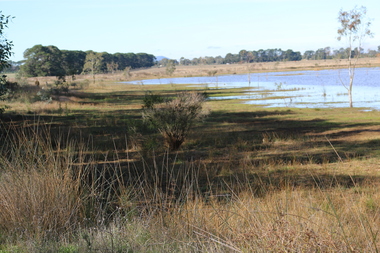
Photograph - Digital photograph, Dorothy Wickham, Winter's Swamp, Ballarat, January to April 2014
... He took up the run Bonshaw from 1841; Leigh River Buninyong 1842-46; Junction, Delatite, March 1851 to September 1862; with sons: Carag Carag and Corop, April 1857 to September 1872; Colbinabbin and Stewart’s Plains, April 1857 to December 1872; St Germains February 1867 to March 1871. ...He took up the run Bonshaw from 1841; Leigh River Buninyong 1842-46; Junction, Delatite, March 1851 to September 1862; with sons: Carag Carag and Corop, April 1857 to September 1872; Colbinabbin and Stewart’s Plains, April 1857 to December 1872; St Germains February 1867 to March 1871. ...Study of Winter's Swamp commissioned by BEN and completed by BHS. The swamp was named after one of the first European settlers in the district. Winter Swamp LAT -37 32 LONG 143 47, Parish of Dowling Forest, County of Grenville Winter Swamp, on the southwest corner of Ballarat West Town Common, was not included in the original proclamation of the Common in 1861. However, being marshland, it was not considered suitable for grazing, so was added to the Common soon after 1861. Winter Swamp is a large wetland with native and exotic pasture significant for wildlife. John Winter (Jock) was born in Berwickshire, Scotland. He married Janet Margaret Irving the daughter of Robert Irving, advocate, Bonshaw, Dumfries, Scotland. Winter died in Ballarat in 1875 and was buried at the Ballaarat Old Cemetery. He took up the run Bonshaw from 1841; Leigh River Buninyong 1842-46; Junction, Delatite, March 1851 to September 1862; with sons: Carag Carag and Corop, April 1857 to September 1872; Colbinabbin and Stewart’s Plains, April 1857 to December 1872; St Germains February 1867 to March 1871. (The name became Winter-Irving in 1890). Mr John Winter, who died on August 22 at the age of 72, was a man of some note it the mining community of Ballarat. He was a self-made man, and one of our oldest colonists, it being over a quarter of a century age since he took up county about Ballarat and settled at Bonshaw. He died very rich. It is calculated that if he had retained an interest in all his runs, his income must have been not less than £10,000 or £50,000 a year. Some eight or ten years ago he sold his Bonshaw pre-emption to the Bonshaw Gold mining Company for £20,000, and a few years later the ground belonging now to Winter's Freehold Company brought him £50,000 more, the payment being made at the requisition of the deceased in sovereigns. In these relations Mr. Winter has been closely identified with the mining industry at Ballarat. The deceased was a native of Lauder, in Berwickshire, and landed in Victoria several years before the gold discovery.The principle task of this project was the delivery of a report outlining the history of European settlement in the Skipton and Cardigan/Ballarat districts as pertinent to the use of and impact on the natural environment of the two reserves Skipton Common and Winter Swamp. The report was delivered in digital form only. The report, upon completion, was presented to the Network’s Committee in order to discuss the project. The report identified and described the uses of Skipton Common and Winter Swamp, and their impacts. In particular, this report examined farming/grazing (official and informal), mining, vegetation removal (including the removal of woodlands for timber, grasslands for pasture improvement) & use of riparian areas for access to water and timber removal. Recording the more benign and environmentally friendly uses such as picnicking, community activities, nature walks and the roles of organisations such as Field Naturalists’ and Bird Observers’ clubs, school and scout/guide groups will be relevant in helping to depict overall community attitudes towards the reserves; e.g.: has the Common generally been viewed as little more than a grazing paddock and fire hazard; has Winter Swamp always been the unknown natural asset that seems to have been its lot for at least the past 40 years? In this regard, the more contemporary history of actions surrounding the use and management of the reserves is of particular interest, in view of the extant evidence at both reserves; e.g. the actions of the Shire of Ballarat in the 1980s in establishing Winter Swamp as something of a competitor to Lake Wendouree but with a more environmental bent (although almost none of the plants used are indigenous species, but that is part of the story); the trotting track constructed on Skipton Common in the 1960s following representations to Premier Henry Bolte and the cropping of the western section of the Common to raise funds for the town’s new swimming pool, the fertilizing of the land putting an end to the native grassland vegetation. There are obviously multiple sources of information to source in preparing the report, however sources that the contractor is specifically requested to consult are the Skipton Historical Society, the former Skipton Common managers (specifically Graeme Pett), the Cardigan Windermere Landcare Group and the Learmonth Historical Society (believed to hold many of the former Shire of Ballarat’s records pertaining to the Council’s role as the Committee of Management for both Winter Swamp and the Ballarat West Town Common – Winter Swamp was split between 2 separate Crown Land tenures). The contractor is also encouraged but not required to utilise community newsletters, such as the Skipton Community Newsletter, to publicise and seek information about the project. Skipton Historical Society (Mary Bradshaw) contacted on Thursday 12 June 2.30pm. Mary lived on a farm out of Skipton but is currently living in the township. She remembers walking along the creek of the Common especially in spring and autumn in bare feet and that it was a very pretty place. There were a few snakes around the waterway in summer. People put cows and a couple of horses on the commonage to graze. Graeme Pett has always lived close to the Common and would know a lot about it. Other possible contacts would be Nicole Petress, Secretary of the Progress Association, and the Corangamite Council, Camperdown. Digital images of Winter's Swampwinter's swamp, ballarat, john winter, ballarat environmental network, mullawullah -
 Bendigo Historical Society Inc.
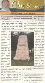
Newspaper - Newspaper articles by Ken Arnold, Out &About, 2000 - 2003
... Myola East School 6.9.02 106. Colbinabbin West 13.9.02 107. Colbinabbin West School 20.9.02 108. ...Myola East School 6.9.02 106. Colbinabbin West 13.9.02 107. Colbinabbin West School 20.9.02 108. ...Ken Arnold is a Bendigo author and publisher.A series of one hundred and thirty-five articles written by Ken Arnold and published in the Bendigo Weekly between 2000 and 2003. Each article has a topic or theme and includes historical information and details. Each article includes a photograph. The articles are stored in a red vinyl covered two ring A5 folder. Index below. Number Article Name Date 1. Centenary of Victoria 19.5.00 2. Storm Water Drain 26.5.00 3. Granite Rollers 2.6.00 4. Poverty Mine 9.6.00 5. Golden Monument. St Arnaud 16.6.00 6. Turner Statue 7.7.00 7. Gold Monument. High St Golden Square 30.6.00 8. Gold Monument. Howard Square Bendigo 14.7.00 9. Lansell Statue 21.7.00 10. Shelbourne West School 18.8.00 11. Mologa’s State Schools 25.8.00 12. Salinity Stone. Pyramid Hill 1.9.00 13. Cairn. Carisbrook 8.9.00 14. Commemorative Markers. Taradale 15.9.00 15. Burke Monument. Castlemaine 22.9.00 16. Cairn. Harcourt area 29.9.00 17. Cairn Marks Gold Route 6.10.00 18. Volcanic Rock Cairn. Woodstock 13.10.00 19. Garfield Water Wheel 20.10.00 20. Anticline. Castlemaine 27.10.00 21. Lawson Bridge 10.11.00 22. Plaque. Sutton Grange area 17.11.00 23. Memorial Cairn. Maryborough 1.12.00 24. Lonely Grave 8.12.00 25. Moonlight Flat Church 5.1.01 26. Historic Church. Near Tullaroop reservoir 12.1.01 27. Granite Statue. Castlemaine 19.1.01 28. Marker. Near Tullaroop reservoir 25.1.01 29. Church Site. Mologa 2.2.01 30. Church Site. Mologa 9.2.01 31. Plaque. Mologa 16.2.01 32. Mincha School 23.2.01 33. Historic Marker. Mincha 2.3.01 34. Expedition Marker. Pyramid Hill 9.3.01 35. Irrigation Marker. Tragowel 16.3.01 36. Mologa School Sites 23.3.01 37. Cairn. Pyramid Hill 30.3.01 38. Plaque. Pyramid Hill 6.4.01 39. Bristol Hill Lookout Tower. Maryborough 12.4.01 40. Eppalock Reservoir 20.4.01 41. Colbinabbin Cairn 27.4.01 42. Mount Macedon Cross 4.5.01 43. Memorial Gateway. Macedon 11.5.01 44. Cairn. Daylesford 18.5.01 45. Grave. Carlsruhe 25.5.01 46. Water Tower. Elmore 1.6.01 47. State School Site. Glenalbyn 8.6.01 48. Cairn. Kanya 15.6.01 49. Lonely Grave. Wedderburn 22.6.01 50. Church Cairn. Glenalbyn 29.6.01 51. Kamarooka School 6.7.01 52. Granite Marker. Moyston 13.7.01 53. Memorial Park. Kerang 20.7.01 54. Water Plaque. Bears Lagoon 27.7.01 55. Cemetery. Bears Lagoon 3.8.01 56. Race Monument 10.8.01 57. Cairn. Pyalong 17.8.01 58. Cairn. In memory of Edward Parker 24.8.01 59. Mt Macedon 31.8.01 60. Mt Macedon Cairn 7.9.01 61. Expedition Pass. Chewton 14.9.01 62. Granite Archway. St Arnaud 21.9.01 63. Stuart Mill School Site 28.9.01 64. School Site. Beazley’s Bridge 5.10.01 65. Fosterville 12.10.01 66. Barnadown 19.10.01 67. Salisbury School Site 26.10.01 68. Cricket History at Wattle Flat 2.11.01 69. School Site. Waterloo Plains 9.11.01 70. Carapooee School Site 11.01 71. Turkish Gun. Maldon 11.01 72. Kooreh 30.11.01 73. Marnoo East School 7.12.01 74. Bulgana Site 14.12.01 75. Emu School 21.12.01 76. Kooroocheang 4.1.02 77. Church Site. Gre Gre North 11.1.02 78. Carmens Tunnel. Maldon 18.1.02 79. Monument. Maldon 25.1.02 80. Woodfull Plaques. Maldon 1.2.02 81. Carapooee. St Peters Anglican Church 8.2.02 82. Cairn. Kingower 15.2.02 83. Cob & Co Stopover. Rheola 22.2.02 84. Flynn Monument 1.3.02 85. The Welcome Stranger. Moliagul 8.3.02 86. Campbell’s Creek Reserve 15.3.02 87. Mine. Fryerstown 22.3.02 88. Escott Grave. Near Chewton 28.3.02 89. School No 808. Kurting area 5.4.02 90. Graves. Bendigo Creek 10.5.02 91. School. Fish Point, Benjeroop North 17.5.02 92. Old Township. Diggora 24.5.02 93. Diggora West (1) 31.5.02 94. Diggora West (2) 7.6.02 95. School No 2735. Gower East 14.6.02 96. Pannoomilloo 21.6.02 97. Kamarooka Settlement 28.6.02 98. Mincha West State School No 1931 5.7.02 99. Bridges. Arnold 12.7.02 100. Woodvale 19.7.02 101. A Famous Son of Raywood. Jack Donaldson 26.7.02 102. Tandarra Area Schools 2.8.02 103. Dingee 9.8.02 104. Avonmore 30.8.02 105. Myola East School 6.9.02 106. Colbinabbin West 13.9.02 107. Colbinabbin West School 20.9.02 108. Runnymede area 27.9.02 109. Wanalta 4.10.02 110. School Sites. Between Wanalta and Carop 11.10.02 111. Burramboot 18.10.02 112. Kangaroo Chair. 25.10.02 113. Mincha South 1.11.02 114. Woodlands Church 8.11.02 115. School site. Sylvaterre 15.11.02 116. Terrick Terrick 22.11.02 117. Leitchville 29.11.02 118. Pennyweight Cemetery. Castlemaine 6.12.02 119. Mincha Area 13.12.02 120. Musk School 20.12.02 121. Dowie Park. Carisbrook 3.1.03 122. Neereman School Site 10.1.03 123. Bald Rock 17.1.03 124. Sylvaterre School Site 24.1.02 125. Carlsruhe 31.1.02 126. Athenaeum. Maldon 7.2.03 127. School. Mincha West 14.2.03 128. Yarraberb 21.2.03 129. Settlement Marker. Ravenswood Estate 28.2.03 130. Comini Reserve. Ravenswood 7.3.03 131. Ironbark and Gold Track. Whroo 14.3.03 132. Burke and Wills Obelisk. Castlemaine 21.3.03 133. James Cook Statue. Myers St Bendigo 28.3.03 134. St Marys Church. Axedale 4 .4.03 135. Butter Factory Site. Warragamba 11.4.03 events, monuments, historical sites, landmarks -
Eltham District Historical Society Inc
Document - Folder, Shelmerdine, Stephen
... Contents Business card: Stephen Shelmerdine, vigneron Stephen Shelmerdine Lusitta Park Vineyard Woori Yallock-Yarra Valley Merindoc Vineyard Tooborac-Heathcote Willoughy Bridge Vineyard Colbinabbin-Heathcote Vineyard Newspaper clippings, A4 photocopies, etc Shelmerdine, Stephen Document Folder ...Stephen Shelmerdine, vigneron. Contents Business card: Stephen Shelmerdine, vigneronNewspaper clippings, A4 photocopies, etcstephen shelmerdine, lusitta park vineyard, woori yallock-yarra valley merindoc vineyard, tooborac-heathcote willoughy bridge vineyard, colbinabbin-heathcote vineyard