Showing 11 items matching "coleman crescent"
-
 Eltham District Historical Society Inc
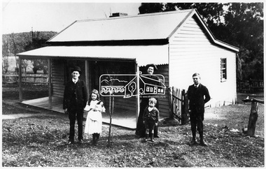
Photograph, Coleman family and home, Main Road, Eltham, c.1909
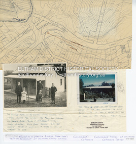
... ...Coleman Crescent...Main Road before it was realigned used to take in the current Coleman Crescent. Same as 1678A. Not in register. ...Main Road before it was realigned used to take in the current Coleman Crescent. Same as 1678A. Not in register. ...Coleman family and home, Coleman’s Corner, Eltham, c.1909 L-R: Tom Newton (school teacher and nephew of Mrs Coleman), Mary Agnes Coleman (later Mrs Dawes 1904-1957), Mrs Mary Ann Coleman nee Bourke (1877-1927); mother of Jack (John Lawrence 1895-1969), George Lawrence (1906-1953) and Mary Agnes (1904-1957). John (Jack) Coleman was father of John Jnr and father in law to Margaret (nee Dare). The cottage was located on a bend of Wattletree Rd near Main Road. Built about 1905 and later extended. Demolished c.2000 for development of units. Main Road before it was realigned used to take in the current Coleman Crescent. Same as 1678A. Not in register. Source: Mrs. M. Coleman, Coleman's Corner, Eltham This photo forms part of a collection of photographs gathered by the Shire of Eltham for their centenary project book,"Pioneers and Painters: 100 years of the Shire of Eltham" by Alan Marshall (1971). The collection of over 500 images is held in partnership between Eltham District Historical Society and Yarra Plenty Regional Library (Eltham Library) and is now formally known as the 'The Shire of Eltham Pioneers Photograph Collection.' It is significant in being the first community sourced collection representing the places and people of the Shire's first one hundred years.Digital image 4 x 5 inch B&W Neg Print 16.5 x 25 cmshire of eltham pioneers photograph collection, coleman cottage, coleman crescent, coleman family, coleman's corner, eltham, george lawrence coleman, jack coleman, john lawrence coleman, main road, mary agnes dawes (nee coleman), mary ann coleman (nee bourke), tom newton, wattletree road, 1909 -
 Eltham District Historical Society Inc
Photograph, Main Road, Eltham near Colemans Corner
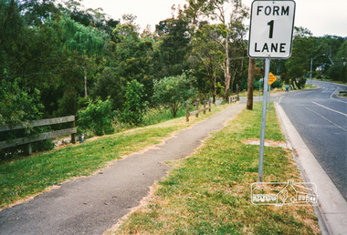
... Colour photograph of Main Road, Eltham looking north near Colemans Corner towards Coleman Crescent on left...Eltham District Historical Society Inc 728 Main Rd Eltham melbourne main road eltham eltham east colemans corner coleman Colour photograph of Main Road, Eltham looking north near Colemans Corner towards Coleman Crescent on left Main Road, Eltham near Colemans Corner Photograph ...Colour photograph of Main Road, Eltham looking north near Colemans Corner towards Coleman Crescent on leftmain road, eltham, eltham east, colemans corner, coleman -
 Eltham District Historical Society Inc
Document - Property Binder, 1203 Main Road, Eltham
... ...Coleman Crescent...Main Road Eltham Property Houses Coleman House Coleman Crescent Mary Coleman Mary Dowes Mary Ann Coleman Mary Ann Burke Jack Coleman George Coleman John Coleman Jock Coleman Margaret Coleman Margaret Dare Dorothy Peatling Mrs Thomas Ken Gaston Frank Martin Vicky Weston Vicky Coleman Frank Burgoyne Heather Bakos Mrs Dansey Wattletree Road Edendale Farm Orchard Avenue Eltham North Diamond Creek Christmas Creek Cobb and Co Royal Mail Miscellaneous clippings, notes, photocopies, etc held on the subject property. 1203 Main Road, Eltham Document Property Binder ...Display panel: Map of Coleman's house location; 1904 photograph of Coleman house with Tom Newton, Mary Coleman (later Dowes) Mary Ann Coleman (nee Burke, mother of Jack Coleman, George Coleman, Mary Coleman), George Coleman, John (Jock) Coleman (father of John Coleman junior married to Margaret Coleman nee Dare); 1971 photograph of part of Coleman house. Typed document, compiled by Dorothy Peatling, Objection to Application 980731 Proposal for 6 units at 1203 Main Road Eltham, stories from Mrs Thomas, Ken Gaston, Frank Martin, Vicky Weston (nee Coleman), Frank Burgoyne, Heather Bakos, Mrs Dansey, and other historical information. Typed document, by Margaret Jennings, Objection to Application 980731 Proposal for 6 units at 1203 Main Road Eltham, history of site. Typed document, by Eltham District Historical Society, history of site, summary of interviews from Dorothy Peatling objection.main road, eltham, property, houses, coleman house, coleman crescent, mary coleman, mary dowes, mary ann coleman, mary ann burke, jack coleman, george coleman, john coleman, jock coleman, margaret coleman, margaret dare, dorothy peatling, mrs thomas, ken gaston, frank martin, vicky weston, vicky coleman, frank burgoyne, heather bakos, mrs dansey, wattletree road, edendale farm, orchard avenue eltham north, diamond creek, christmas creek, cobb and co royal mail -
 Eltham District Historical Society Inc
Photograph, Diamond Creek Bridge, Eltham North, c.1920
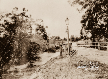
... ...coleman crescent... - Research by Peter Pidgeon, EDHS, June 2026 eltham north wattletree road coleman crescent bridges Diamond Creek (Creek) Bridge Carbide streetlamp Floodwater Glen Park Bridge Street Lamp Glen Park Road Glen Park Estate Photograph copy Diamond Creek Bridge, Eltham North Photograph ...View looking east across the Glen Park Bridge and the railway crossing towards Main Road circa 1920. The bridge was originally built as a replacement for an older private bridge built by a man named Foley around 1880. In 1911 Heidelberg and Eltham agreed to share the costs to build a new bridge (the Diamond Creek was the border between the two). Construction began in June 1915 and it was officially opened by Cr. Taylor on Cup Day, November 1915. This photo, dated around 1920, is of the Glen Park Bridge crossing over the Diamond Creek about 50 metres north of the present-day Wattletree tree Road Bridge. Glen Park Road intersected Main Rain Road along an alignment following present day Coleman Cresent. In this this picture we see the narrow wooden bridge over a high flowing Diamond Creek at Glen Park, now Eltham North. In the background is a railway crossing sign. There is a self-contained carbide streetlamp situated in front of the bridge. In the early 1900s, carbide (acetylene gas) streetlamps emerged as a lighting technology for regional towns across Victoria, Australia, before municipal electricity grids were widely established. During the late Victorian and early Edwardian eras, major hubs like Melbourne relied on centralized coal-gas infrastructure. However, small regional Victorian shires lacked the funds or population density to build large gasworks. When the commercial production of calcium carbide became viable around 1900, it offered a quantum leap in brightness over traditional kerosene streetlamps. Acetylene gas burned with an intense, crisp white flame—significantly brighter than oil or candles. Many rural towns used self-contained lampposts. A lamplighter had to climb each post daily to manually place calcium carbide pellets in a lower chamber and fill an upper chamber with water. The water dripped onto the carbide, producing acetylene gas to feed the burner. Lamplighters carefully measured the fuel amounts so the chemical reaction would naturally exhaust itself and "turn off" around midnight. While carbide streetlights provided unparalleled visibility for early motorists, cyclists, and pedestrians, they were incredibly labour-intensive and inherently volatile. The gas was highly explosive, prone to leaks, and left behind a pungent, sulphur-like odour. By the end of World War I, local Victorian councils rapidly phased out acetylene infrastructure in favour of safer, independent electric powerhouse generators. In the context of Eltham's local history, the Eltham Shire and surrounding Yarra Valley region actively relied on carbide streetlamps and kerosene lighting during the early 20th century before the expansion of the Melbourne electric grid. Eltham was an outer-rural, heavily timbered farming and orchard district at the turn of the century, it faced unique civic infrastructure challenges. In rural Eltham, early streetlamps were exceptionally sparse. The community relied heavily on "innkeeper laws" which dictated local hotels—such as the historic Eltham Hotel—were legally required to keep external oil, kerosene, or acetylene lamps burning through the night to illuminate the main roads for travellers and coaches. The volatile carbide and kerosene lamps on Eltham's main thoroughfares were progressively phased out during the 1920s. The district steadily transitioned to electricity, which allowed for developments like the installation of modern electrical wiring at the local fire station on Arthur Street by 1928. The Glen Park Bridge was a low structure and subject to flooding readily. In 1959 Eltham Council erected a new crossing over the Diamond Creek and realigned the road to the present-day Wattletree Road Bridge. Construction was not fully complete when on Sunday, 20 September 1959, heavy flooding occurred in the stream and at 3:53 pm the old bridge was washed away forever. - Research by Peter Pidgeon, EDHS, June 2026Photograph copy eltham north, wattletree road, coleman crescent, bridges, diamond creek (creek), bridge, carbide streetlamp, floodwater, glen park bridge, street lamp, glen park road, glen park estate -
 Eltham District Historical Society Inc
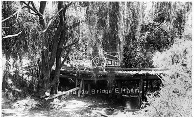
Negative - Photograph, Tom Prior, Langlands Bridge, Eltham, c.1900
... It is possible that the bidge may have crossed the Diamond Creek to Langland's land along the original alignment of Glen Park Road which used to run between present day Progress Road and Coleman Crescent. SEPP Source (c.1970): Mrs. E.R. ...It is possible that the bidge may have crossed the Diamond Creek to Langland's land along the original alignment of Glen Park Road which used to run between present day Progress Road and Coleman Crescent. SEPP Source (c.1970): Mrs. E.R. ...It is noted in the Reynolds Prior collection (Ivy Reynolds) as the first bridge in Eltham however given the current state of knowledge, this is considered unlikely and there is no other supporting source. John Hunter Langlands, owner of the farm known as ‘Ihurst’ on the west side of Diamond Creek to the south of John Wright Murray’s land, died in 1907. In 1909 his land was subdivided into 100 lots to become the ‘Glen Park Estate’. It is possible that the bidge may have crossed the Diamond Creek to Langland's land along the original alignment of Glen Park Road which used to run between present day Progress Road and Coleman Crescent. SEPP Source (c.1970): Mrs. E.R. Reynolds, Thompson Crescent, Research The Reynolds family were early settlers in Research. The Reynolds/ Prior collection of photographs were taken by Tom Prior, the maternal uncle of Ivy Reynolds, around 1900 and the 60 photos in the album give a fine overview of many of the landmarks of Research and Eltham over 100 years ago. lvy lived in the family home for many years at 106 Thompson Cres Research. Ivy's father, Ernst Richard Reynolds and grandfather, Richard Reynolds, lived at the same address. Ivy's father Richard worked for Mr. Trail on his property in Research. Reynolds Road is named after the family. Mr Tom Prior (wife Eva) worked at the Melbourne zoo. He was very innovative and made his own camera, using the black cloth hood to exclude the light. The photographs are a reminder of the rural nature of Research and Eltham and its rich heritage. This photo forms part of a collection of photographs gathered by the Shire of Eltham for their centenary project book,"Pioneers and Painters: 100 years of the Shire of Eltham" by Alan Marshall (1971). The collection of over 500 images is held in partnership between Eltham District Historical Society and Yarra Plenty Regional Library (Eltham Library) and is now formally known as the 'The Shire of Eltham Pioneers Photograph Collection.' It is significant in being the first community sourced collection representing the places and people of the Shire's first one hundred years.Digital image 4 x 5 inch B&W Neg B&W printsepp, shire of eltham pioneers photograph collection, eltham, langlands bridge, reynolds prior collection, bridge, john hunter langlands -
 Ringwood and District Historical Society
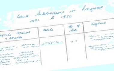
Document - Research Notes, Richard Carter, Land Subdivisions in Ringwood 1890-1950
... (1923) Mullum Road, The Centreway, Wattle Crescent (now Wattle Avenue) Reserve Crescent (now Reserve Road) Pg15 DUBLIN ROAD ESTATE LP11993 (1923) Alexandra Road, Vonadawn Avenue, Green Street, Wood Street, Howard Avenue, Bedford Road, Dublin Road Pg16 CARLINGA ESTATE RINGWOOD LP9620 (1923) Bourke Street, Bond Street, Ringwood Street Pg17 PRATT'S JUNCTION ESTATE (LP?) (1923) Junction Street, Georges Road, Oliver Street, Whitehorse Road Pg18 EAST RINGWOOD ESTATE LP10492 (1923) Bona Street, Patterson Street, Miller Grove, Fairview Avenue, Eastfield Road, Whitehorse Road (now Mount Dandenong Road) Pg19 COLEMAN'S HEATHMONT ESTATE LP9974 (1923) Canterbury Road, Bedford Road, Alvena Crescent, Coleman Street, Leonard Street (now Royal Avenue) Pg20 RINGWOOD HEIGHTS ESTATE LP10506 (1924) Whitehorse Road, Bonview Avenue, Grant Crescent, Hillcrest Avenue, Heatherbrae Avenue, Margaret Street, Mary Street Pg21 EAST RINGWOOD STATION ESTATE LP10551 (1924) Knaith Road, Wenwood Street, Lois Street, Victoria Street, Station Street (now Railway Avenue) Pg22 GRAND VIEW ESTATE LP11019 (1924) Whitehorse Road, Rupert Street, Herbert Street, Leonard Street Pg23 RINGWOOD RAILWAY ESTATE & RINGWOOD HEIGHTS ESTATE - FINAL SECTIONS LP10506 & LP10507 (1924) Whitehorse Road, Sherbrooke Avenue, Burwood Avenue, Bonview Avenue, Heatherbrae Avenue, Margaret Street, Mary Street, Grant Crescent Pg24 RINGWOOD EAST ELECTRIC STATION ESTATE (LP?) ...(1923) Mullum Road, The Centreway, Wattle Crescent (now Wattle Avenue) Reserve Crescent (now Reserve Road) Pg15 DUBLIN ROAD ESTATE LP11993 (1923) Alexandra Road, Vonadawn Avenue, Green Street, Wood Street, Howard Avenue, Bedford Road, Dublin Road Pg16 CARLINGA ESTATE RINGWOOD LP9620 (1923) Bourke Street, Bond Street, Ringwood Street Pg17 PRATT'S JUNCTION ESTATE (LP?) (1923) Junction Street, Georges Road, Oliver Street, Whitehorse Road Pg18 EAST RINGWOOD ESTATE LP10492 (1923) Bona Street, Patterson Street, Miller Grove, Fairview Avenue, Eastfield Road, Whitehorse Road (now Mount Dandenong Road) Pg19 COLEMAN'S HEATHMONT ESTATE LP9974 (1923) Canterbury Road, Bedford Road, Alvena Crescent, Coleman Street, Leonard Street (now Royal Avenue) Pg20 RINGWOOD HEIGHTS ESTATE LP10506 (1924) Whitehorse Road, Bonview Avenue, Grant Crescent, Hillcrest Avenue, Heatherbrae Avenue, Margaret Street, Mary Street Pg21 EAST RINGWOOD STATION ESTATE LP10551 (1924) Knaith Road, Wenwood Street, Lois Street, Victoria Street, Station Street (now Railway Avenue) Pg22 GRAND VIEW ESTATE LP11019 (1924) Whitehorse Road, Rupert Street, Herbert Street, Leonard Street Pg23 RINGWOOD RAILWAY ESTATE & RINGWOOD HEIGHTS ESTATE - FINAL SECTIONS LP10506 & LP10507 (1924) Whitehorse Road, Sherbrooke Avenue, Burwood Avenue, Bonview Avenue, Heatherbrae Avenue, Margaret Street, Mary Street, Grant Crescent Pg24 RINGWOOD EAST ELECTRIC STATION ESTATE (LP?) ...Handwritten table listing main local pre-1950s subdivisions in the Ringwood area, with estate names, streets, number of allotments for sale, and where known, vendor agent, LP (Lodged Plan) title registration number, and auction/sale date, some with sale price.Pg1 RINGWOOD STATION ESTATE LP3070 (Year?) Station Street, William Street (now Kendall Street), Wantirna Road, Station Street Pg1 RINGWOOD TOWNSHIP ESTATE LP5577 (1913) Station Road (now Warrandyte Road), Pratt Street (part now Aird Street), Whitehorse Road Pg2 RINGWOOD ORCHARD ESTATE LP4315 (1914) Brysons Road, Hillcrest Road, Anzac Avenue, Sulva Road Pg3 RINGWOOD RAILWAY ESTATE LP7522 (1918) Whitehorse Road (now Mount Dandenong Road), Dublin Road, Freeman Street, Patterson Street, Bona Street Pg4 THE RINGWOOD ESTATE LP7578 (1919) Warrandyte Road, Hobart Street, Paxton Street, Arnold Street Pg5 GARDEN FARMS ESTATE (LP?) (1919) Canterbury Road, Armstrong Road, Bungalook Road, Orchard Road, Bayswater Road (now Mountain Highway) Pg6 THE RINGWOOD ESTATE (SECOND SUB-DIVISION) LP7604 (1919) Warrandyte Road, Tamar Street, Derwent Street, Mersey Street Pg7 RINGWOOD STATION ESTATE LP7703 (1919) Bedford Road, Williams Grove (now Lena Grove) Pg8 RINGWOOD TOWNSHIP ESTATE LP8198 (1919) Wantirna Road, Ellison Street, Haig Street, Greenwood Avenue Pg9 EASTFIELD ESTATE (LP?) (1920) Eastfield Road, Longview Road, Pleasant Rise, The Mount Pg10 ELECTRIC RAILWAY ESTATE RINGWOOD LP9473 (1922) Campbell Street, Myrtle Avenue, George Street (now Tudor Court), Henry Street (now Myrtle Avenue), Williams Grove (now Lena Grove) Pg11 RINGWOOD PARK ESTATE LP7884 (1922 - two stages) Wonga Road (now Loughnan Road), William Street, Andrew Street, Harrison Street Pg12 HEATHMONT STATION ESTATE LP11009 (Date? - after 1922) Lisgoold Street, Viviani Crescent, Balrour Avenue, Station Street (now part Heathmont Road and part Wainui Street) Pg13 RINGWOOD RAILWAY ESTATE LP10507 (1923) Whitehorse Road, Sherbrooke Avenue, Burwood Avenue, Bonview Avenue, Heatherbrae Avenue, Grant Crescent Pg14 GARDEN HOMES ESTATE (LP?) (1923) Mullum Road, The Centreway, Wattle Crescent (now Wattle Avenue) Reserve Crescent (now Reserve Road) Pg15 DUBLIN ROAD ESTATE LP11993 (1923) Alexandra Road, Vonadawn Avenue, Green Street, Wood Street, Howard Avenue, Bedford Road, Dublin Road Pg16 CARLINGA ESTATE RINGWOOD LP9620 (1923) Bourke Street, Bond Street, Ringwood Street Pg17 PRATT'S JUNCTION ESTATE (LP?) (1923) Junction Street, Georges Road, Oliver Street, Whitehorse Road Pg18 EAST RINGWOOD ESTATE LP10492 (1923) Bona Street, Patterson Street, Miller Grove, Fairview Avenue, Eastfield Road, Whitehorse Road (now Mount Dandenong Road) Pg19 COLEMAN'S HEATHMONT ESTATE LP9974 (1923) Canterbury Road, Bedford Road, Alvena Crescent, Coleman Street, Leonard Street (now Royal Avenue) Pg20 RINGWOOD HEIGHTS ESTATE LP10506 (1924) Whitehorse Road, Bonview Avenue, Grant Crescent, Hillcrest Avenue, Heatherbrae Avenue, Margaret Street, Mary Street Pg21 EAST RINGWOOD STATION ESTATE LP10551 (1924) Knaith Road, Wenwood Street, Lois Street, Victoria Street, Station Street (now Railway Avenue) Pg22 GRAND VIEW ESTATE LP11019 (1924) Whitehorse Road, Rupert Street, Herbert Street, Leonard Street Pg23 RINGWOOD RAILWAY ESTATE & RINGWOOD HEIGHTS ESTATE - FINAL SECTIONS LP10506 & LP10507 (1924) Whitehorse Road, Sherbrooke Avenue, Burwood Avenue, Bonview Avenue, Heatherbrae Avenue, Margaret Street, Mary Street, Grant Crescent Pg24 RINGWOOD EAST ELECTRIC STATION ESTATE (LP?) (1924) Railway Parade (now Patterrson Street), Federal Road, Howship Avenue (part now French Street), Dublin Road, Rosedale Crescent Pg25 BEDFORD PARK (now Ringwood Secondary College) (LP?) (1924) Bedford Road, Adams Street, Anderson Street, Joyce Street, Graham Road Pg26 CROWN JEWEL ESTATE LP11645 (Private sales after 1924) Mount Dandenong Road, Mirabel Avenue, Valda Avenue, Evon Avenue, Velma Grove Pg27 GRAND CENTRAL ESTATE LP10917 (1925) Heathmont Road, Great Ryrie Street, Douglas Street, Garden Street, Bellevue Avenue Pg28 RINGWOOD (unnamed estate - 1926) Nelson Street, Seymour Street, Whitehorse Road Pg29 EAST RINGWOOD RAILWAY STATION ESTATE (YEAR? - 25 shops 60 villas) Railway Avenue, Dublin Road, Lawrence Grove, Stanley Avenue, Knaith Road Pg30 CHARM VIEW ESTATE (LP?) (year? - after 1926) Canterbury Road, Heathmont Road, Dickasons Road, Bennjett Avenue, Orchid Street Pg31 SUNBEAM ESTATE LP12150 (Circa 1925) Govt Road (now Old Lilydale Road), Sunbeam Avenue, Holland Road, Everard Street (now Everard Road) Pg32 FAIRVIEW ESTATE EAST RINGWOOD LP10853 (Circa 1924) Eastfield Road, Patterson Street, Margaret Street (now Short Street) Pg33 EAST RINGWOOD TOWNSHIP ESTATE LP3025 (Circa 1924 - 35 allotments) Mount Dandenong Road, Grey Street, Eastfield Road Pg34 EAST RINGWOOD TOWNSHIP ESTATE LP3025 (Circa 1924 - 49 allotments) and STATE SCHOOL ESTATE (26 allotments) and EAST RINGWOOD STATION ESTATE (14 shop sites) Mount Dandenong Road, Grety Street, Dunn Street, Eastfield Road, King Street, Holland Road, Dublin Road, Patterson Street, Bona Street Pg35 EAST RINGWOOD CENTRAL ESTATE LP17004 (1948) Knaith Road, Shasta Avenue, Talofa Avenue, Russet Road, Dublin Road Pg36 WARE ESTATE LP43360 (1958) Ware Crescent, Davey Drive, Grey Road (now Grey Street), Mount Dandenong Road Pg37 Lot 57 Kendall Street LP3070 (1939) £75.0.0 Pg37 Lot 14 LP7346 (year?) £225 Pg37 Lot 8 WHITE HORSE ESTATE LP14010 (year?) Maroondah Hwy, Seymour Street £98.9.0 Pg37 Lots 4-14 incl. LP10902 (year?) £300 Pg37 Lots 69&70 LP2216 (1939) Bedford Road, Pitt Street £500 Pg37 Lots 60&70 LP2216 (year?) £460 Pg37 MOUNTAIN VIEW ESTATE LP10902 (1936) Lots 1&2, 19-22 Wantirna Road, Daisy Street £50 Pg38 RAILWAY STATION ESTATE RINGWOOD EAST LP7522 (1925) Lots 16 to 19 £250 Pg38 RINGWOOD PARK ESTATE (LP?) (1924) Lot 112 Munro Street £230 Pg38 RINGWOOD TOWNSHIP ESTATE (LP?) (1925) Lot 57 Wantirna Road £850 Pg38 ELECTRIC RAILWAY ESTATE LP9473 (1925) Lot 98 & 99 £180 (30/- foot) Pg38 ELECTRIC RAILWAY ESTATE LP9473 (year?) Lot 100 £233.12.6 incl improvements (£2.12.6 foot) Pg38 Lot 22&23 Bedford Road Heathmont (LP & year?) £675 incl improvements Pg39 Lot 9 Mullum Mullum Road LP8221 (1923) £150 Pg39 Lot 27 Haig Street LP8198 (1925) £825 Pg39 Lot 56 Haig Street cnr Wantirna Road LP8198 (1923) £171 Pg39 Lots 3 & 4 Loughnan Road LP9626 (192?) £147 Pg39 Lots 98 & 99 Myrtle Avenue LP9473 (1925) £180 Pg39 Lots 80 & 81 Myrtle Avenue LP9473 (1929) £150 Pg39 Lot 30 Sherbrooke Avenue LP10507 (1926) £700 incl improvements Pg40 Lot 10 (year?) LP7703 £750 Pg40 Lot 36 (year?) LP7522 £25 Pg40 Lot 38 Pitt Street LP2216 (year?) £350 Pg40 Lot 7 Dublin Road cnr Green Street LP11993 (year?) £300 -
 Ringwood and District Historical Society
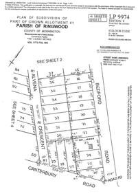
Document - Subdivision Plan, LP9974 Part of Crown Allotment 41, Parish of Ringwood, County of Mornington Vol 1773 Fol 464 - 1924
... Sheet 4 includes Alvena Crescent, Royal Avenue, Coleman Street and Canterbury Road, Heathmont. ...Sheet 4 includes Alvena Crescent, Royal Avenue, Coleman Street and Canterbury Road, Heathmont. ...LANDATA Land Victoria 4-sheet plan printout dated 2009Sheet 1 includes Alvena Crescent, Bedford Road and Canterbury Road, Heathmont. Additional markings include RP16869. Sheet 2 includes Alvena Crescent and Bedford Road, Heathmont. Additional markings include PS318390 and CP161633. Sheet 3 includes Bedford Road, Alvena Crescent and Royal Avenue, Heathmont. Additional markings include RP454. Street name amended from Leonard Street to Royal Avenue Vide Gaz 1962 P.427. Sheet 4 includes Alvena Crescent, Royal Avenue, Coleman Street and Canterbury Road, Heathmont. Additional markings include SP27861, PS305057, RP10566, SP34722 and LP116573. -
 Ringwood and District Historical Society
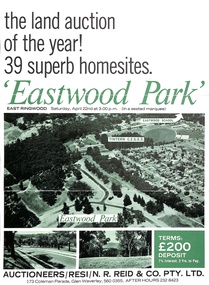
Document - Folder, Eastwood Park Subdivision, Ringwood East, Vic. - Land Sale Circa 1967 - Site of former Eastwood/Eastfield Golf Course
... Subdivision includes Croydon South streets, Andrew Crescent and Banksia Court. Agents - N.R. Reid & Co Pty Ltd, 173 Coleman Parade, Glen Waverley, Tel. 560 0355 A.H. 232 8423....Subdivision includes Croydon South streets, Andrew Crescent and Banksia Court. Agents - N.R. Reid & Co Pty Ltd, 173 Coleman Parade, Glen Waverley, Tel. 560 0355 A.H. 232 8423. ...Subdivision is advertised as including homesites on former Eastwood Golf Course fairways and land contours.Collection of subdivision maps, and double-sided advertisement for auction sale on Saturday, April 22nd, 1967, with summary of local features and services. Subdivision includes Croydon South streets, Andrew Crescent and Banksia Court. Agents - N.R. Reid & Co Pty Ltd, 173 Coleman Parade, Glen Waverley, Tel. 560 0355 A.H. 232 8423.Handwritten sales notations include "Vendor - Willcroft Development P/L 54-60 Southern Road Mentone Tel 93-1267 (Mrs. Morley). Lot 19 $5200, Lot 25 $4500, Lot 28 $3800, Lot 29 $3700, Lot 30 $3600. $400 deposit balance 3 yrs @ 7% $40 per month. All C/S to be prepared by vendor. 5% discount for cash." -
 Ringwood and District Historical Society
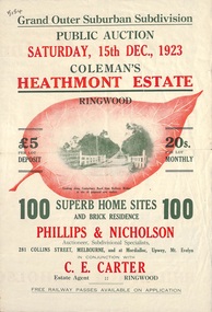
Flyer, Land Sale Brochure, Coleman's Heathmont Estate, Ringwood, Vic. - 1923
... Subdivision includes Bedford Road, Canterbury Road, Alvena Crescent, Leonard Street (later Royal Avenue), and Coleman Street. Agent - Phillips & Nicholson, 281 Collins Street Melbourne, (Phone) Central 10907, in conjunction with C.E. ...Ringwood and District Historical Society 125A Warrandyte Road Ringwood North melbourne Subdivision includes Bedford Road, Canterbury Road, Alvena Crescent, Leonard Street (later Royal Avenue), and Coleman Street. Agent - Phillips & Nicholson, 281 Collins Street Melbourne, (Phone) Central 10907, in conjunction with C.E. ...Bi-fold advertisement for auction sale of residential sites, including photographs, map, and summary of subdivision features and local facilities. Auction date Saturday 15th December, 1923. Subsequent auction date Saturday 19th January, 1924, following previous sale stopped on account of rain. Initial newspaper advertisement (publication unknown) dated 16/11/23.Subdivision includes Bedford Road, Canterbury Road, Alvena Crescent, Leonard Street (later Royal Avenue), and Coleman Street. Agent - Phillips & Nicholson, 281 Collins Street Melbourne, (Phone) Central 10907, in conjunction with C.E. Carter, Main Street, Ringwood. Tel. Ringwood 24. -
 Ringwood and District Historical Society
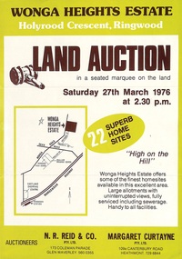
Flyer, Land Auction Advertisement - Wonga Heights Estate, North Ringwood, Victoria - 1976
... Subdivision includes Wonga Road, Holyrood Crescent, Georgian Court, and Stonnington Place. Auctioneers - N.R. Reid & Co. Pty. Ltd., 173 Coleman Parade, Glen Waverley (Telephone) 560 0355, and Margaret Curtayne Pty. ...Ringwood and District Historical Society 125A Warrandyte Road Ringwood North melbourne Subdivision includes Wonga Road, Holyrood Crescent, Georgian Court, and Stonnington Place. Auctioneers - N.R. Reid & Co. Pty. Ltd., 173 Coleman Parade, Glen Waverley (Telephone) 560 0355, and Margaret Curtayne Pty. ...Double-sided printed page advertising land auction on Saturday 27th March, 1976, with locality map and subdivision layout, terms of sale, and summary of local features and services. Subdivision includes Wonga Road, Holyrood Crescent, Georgian Court, and Stonnington Place. Auctioneers - N.R. Reid & Co. Pty. Ltd., 173 Coleman Parade, Glen Waverley (Telephone) 560 0355, and Margaret Curtayne Pty. Ltd., 109a Canterbury Road, Heathmont (Telephone) 729 6844. -
 Lakes Entrance Historical Society
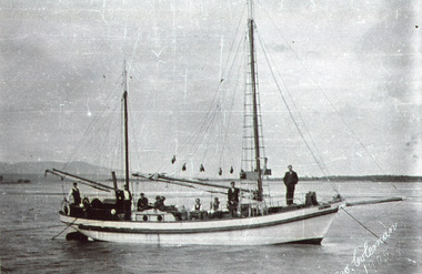
Photograph - Crescent, 1905 c
... Crescent' built at Eden NSW about 1905. After a long lay up she was bought by David Coote, Lakes Entrance, about 1925. Fishing Industry Ships and Shipping Waterways Geo. Coleman ...Note in album from Reg Schulz. Ketch 'Crescent' built at Eden NSW about 1905. After a long lay up she was bought by David Coote, Lakes Entrance, about 1925.Black and white photograph showing ketch Crescent at Mallacoota Inlet. Howe Range in background. Nine men onboard. Mallacoota VictoriaGeo. Coleman 1905fishing industry, ships and shipping, waterways