Showing 12 items matching "combined drain"
-
 Ballarat Heritage Services
Plan, 105 Lyons St Sewerage Plans
... ...Combined drain...Ballarat Heritage Services PO Box 2209 Bakery Hill Post Office goldfields Sewerage plans 105 Lyons Street South Combined drain combined sewer 105 Lyons St Sewerage Plans Plan ...sewerage plans, 105 lyons street south, combined drain, combined sewer -
 Ringwood and District Historical Society
Newspaper, Scrapbook Clipping, Library Collection, Ringwood, Victoria
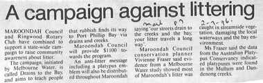
... Maroondah Council and Ringwood Rotary Club have combined to support a state-wide campaign to raise community awareness about litter. The campaign, initiated by Melbourne Water is called Drains to the Bay and aims to teach people that rubbish finds its way to Port Phillip Bay via drains and creeks....Ringwood and District Historical Society 125A Warrandyte Road Ringwood North melbourne Maroondah Council and Ringwood Rotary Club have combined to support a state-wide campaign to raise community awareness about litter. The campaign, initiated by Melbourne Water is called Drains to the Bay and aims to teach people that rubbish finds its way to Port Phillip Bay via drains and creeks. ...Newspaper clipping from "The Mail", 2-7-96, P 7Maroondah Council and Ringwood Rotary Club have combined to support a state-wide campaign to raise community awareness about litter. The campaign, initiated by Melbourne Water is called Drains to the Bay and aims to teach people that rubbish finds its way to Port Phillip Bay via drains and creeks. -
 Wodonga & District Historical Society Inc
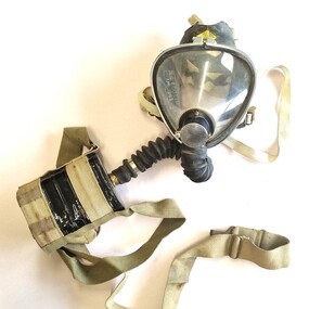
Tool - Sieba Gordon Gas Mask - North East Water Authority, Siebe Gorman & Co. Ltd, c1960
... drained and decommissioned after the No 1 Basin on Huon Hill was completed in 1958. In 1983 the Wodonga Waterworks Trust and the Wodonga Sewerage Authority became part of the Wodonga Council. And by 1989 a filtration plant at Huon Hill was completed, which provided filtered water of improved quality to Wodonga, in accordance with the World Health Organisation’s guidelines. In 1994 the Kiewa Murray Region Water Authority took over the Wodonga Council’s water and wastewater operations, and then in 1999 the Kiewa Murray Region Water Authority combined...drained and decommissioned after the No 1 Basin on Huon Hill was completed in 1958. In 1983 the Wodonga Waterworks Trust and the Wodonga Sewerage Authority became part of the Wodonga Council. And by 1989 a filtration plant at Huon Hill was completed, which provided filtered water of improved quality to Wodonga, in accordance with the World Health Organisation’s guidelines. In 1994 the Kiewa Murray Region Water Authority took over the Wodonga Council’s water and wastewater operations, and then in 1999 the Kiewa Murray Region Water Authority combined ...This mask set is part of the North East Region Water Authority collection in the Wodonga Historical Society. Wodonga's drinking water and wastewater operations were originally managed by the Wodonga Waterworks Trust, which was established in 1897, after Wodonga became a separate shire in 1876. In 1923 a Wodonga Waterworks Trust referendum to provide funding for new infrastructure to supply more water of better quality to Wodonga was passed. This included building the Wodonga Water Tower and it was completed in 1924. It supplied water to Wodonga until 1959, when it was drained and decommissioned after the No 1 Basin on Huon Hill was completed in 1958. In 1983 the Wodonga Waterworks Trust and the Wodonga Sewerage Authority became part of the Wodonga Council. And by 1989 a filtration plant at Huon Hill was completed, which provided filtered water of improved quality to Wodonga, in accordance with the World Health Organisation’s guidelines. In 1994 the Kiewa Murray Region Water Authority took over the Wodonga Council’s water and wastewater operations, and then in 1999 the Kiewa Murray Region Water Authority combined with the Ovens Region Water Authority and became the North East Region Water Authority or NERWA. NERWA then became known as North East Water. Siebe Gorman was a British manufacturer of industrial respirators that served the mining industry, the chemical industry, and the agricultural industry from 1938 until the 1980s. The "Puretha" line refers to the canister included, which was designed to tackle industrial hazards.Siebe Gorman "Puretha" Type C Kit with Vista Vision Facepiece. The facepiece consists of a formed plastic lens held on by a white retaining ring that stretches around the rubber facepiece and is connected by two thumbscrew lugs. The exhale assembly is covered by a steel mesh.The hose is a standard industrial hose. The canister is attached by a khaki webbing material. An instruction sheet is included. The kit is a small leather case with two front latches. Safety instructions and chemical information on canister label. On label: EVERYTHING FOR SAFETY EVERYWHERE Date filled 28 DEC 1961 NO. 675 north east region water authority, gas mask, respirator, sieba gordon -
 Wodonga & District Historical Society Inc
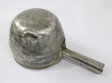
Functional object - Sand Scoop, North East Region Water Authority, Wodonga
... drained and decommissioned after the No 1 Basin on Huon Hill was completed in 1958. In 1983 the Wodonga Waterworks Trust and the Wodonga Sewerage Authority became part of the Wodonga Council. And by 1989 a filtration plant at Huon Hill was completed, which provided filtered water of improved quality to Wodonga, in accordance with the World Health Organisation’s guidelines. In 1994 the Kiewa Murray Region Water Authority took over the Wodonga Council’s water and wastewater operations, and then in 1999 the Kiewa Murray Region Water Authority combined...drained and decommissioned after the No 1 Basin on Huon Hill was completed in 1958. In 1983 the Wodonga Waterworks Trust and the Wodonga Sewerage Authority became part of the Wodonga Council. And by 1989 a filtration plant at Huon Hill was completed, which provided filtered water of improved quality to Wodonga, in accordance with the World Health Organisation’s guidelines. In 1994 the Kiewa Murray Region Water Authority took over the Wodonga Council’s water and wastewater operations, and then in 1999 the Kiewa Murray Region Water Authority combined ...The large aluminium sand scoop was used by Wodonga Waterworks Trust and it is part of the North East Region Water Authority collection in the Wodonga Historical Society. Wodonga's drinking water and wastewater operations were originally managed by the Wodonga Waterworks Trust, which was established in 1897, after Wodonga became a separate shire in 1876. In 1923 a Wodonga Waterworks Trust referendum to provide funding for new infrastructure to supply more water of better quality to Wodonga was passed. This included building the Wodonga Water Tower and it was completed in 1924. It supplied water to Wodonga until 1959, when it was drained and decommissioned after the No 1 Basin on Huon Hill was completed in 1958. In 1983 the Wodonga Waterworks Trust and the Wodonga Sewerage Authority became part of the Wodonga Council. And by 1989 a filtration plant at Huon Hill was completed, which provided filtered water of improved quality to Wodonga, in accordance with the World Health Organisation’s guidelines. In 1994 the Kiewa Murray Region Water Authority took over the Wodonga Council’s water and wastewater operations, and then in 1999 the Kiewa Murray Region Water Authority combined with the Ovens Region Water Authority and became the North East Region Water Authority or NERWA. NERWA then became known as North East Water. The sand scoop has local significance as part of the North East Region Water Authority collection donated to the Wodonga Historical Society. It also has wider state significance as a rare example of the equipment used in water management in Wodonga.Large aluminium scoop with a handle soldered on one side edge and a repair riveted to the interior surface of the scoop where the handle is located. The repair is a piece of sheet metal, with what looks like the lower part of the letter 'S' on it.Lower part of the letter "S" on the repair riveted to the interior surface of the scoop.north east region water authority, nerwa, wodonga waterworks trust, north east water, n.e. water, kiewa murray region water authority, metal scoop, sand scoop -
 Wodonga & District Historical Society Inc
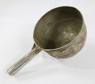
Functional object - Sand Scoop, North East Region Water Authority, Wodonga
... drained and decommissioned after the No 1 Basin on Huon Hill was completed in 1958. In 1983 the Wodonga Waterworks Trust and the Wodonga Sewerage Authority became part of the Wodonga Council, and by 1989 a filtration plant at Huon Hill was completed, which provided filtered water of improved quality to Wodonga, in accordance with the World Health Organisation’s guidelines. In 1994 the Kiewa Murray Region Water Authority took over the Wodonga Council’s water and wastewater operations, and then in 1999 the Kiewa Murray Region Water Authority combined...drained and decommissioned after the No 1 Basin on Huon Hill was completed in 1958. In 1983 the Wodonga Waterworks Trust and the Wodonga Sewerage Authority became part of the Wodonga Council, and by 1989 a filtration plant at Huon Hill was completed, which provided filtered water of improved quality to Wodonga, in accordance with the World Health Organisation’s guidelines. In 1994 the Kiewa Murray Region Water Authority took over the Wodonga Council’s water and wastewater operations, and then in 1999 the Kiewa Murray Region Water Authority combined ...The large aluminium sand scoop was used by Wodonga Waterworks Trust and it is part of the North East Region Water Authority collection in the Wodonga Historical Society. Wodonga's drinking water and wastewater were originally managed by the Wodonga Waterworks Trust, which was established in 1897, after Wodonga became a separate shire in 1876. In 1923 a Wodonga Waterworks Trust referendum to provide funding for new infrastructure to supply more water of better quality to Wodonga was passed. This included building the Wodonga Water Tower and it was completed in 1924. It supplied water to Wodonga until 1959, when it was drained and decommissioned after the No 1 Basin on Huon Hill was completed in 1958. In 1983 the Wodonga Waterworks Trust and the Wodonga Sewerage Authority became part of the Wodonga Council, and by 1989 a filtration plant at Huon Hill was completed, which provided filtered water of improved quality to Wodonga, in accordance with the World Health Organisation’s guidelines. In 1994 the Kiewa Murray Region Water Authority took over the Wodonga Council’s water and wastewater operations, and then in 1999 the Kiewa Murray Region Water Authority combined with the Ovens Region Water Authority and became the North East Region Water Authority or NERWA. NERWA then became known as North East Water. The sand scoop has local significance as part of the North East Region Water Authority collection donated to the Wodonga Historical Society. It also has wider state significance as a rare example of the equipment used in water management in Wodonga.Large aluminium scoop with a handle soldered on one side edge. Two holes and one indent in the end of the handle.north east region water authority, nerwa, wodonga waterworks trust, north east water, n.e. water, kiewa murray region water authority, sand scoop, metal scoop -
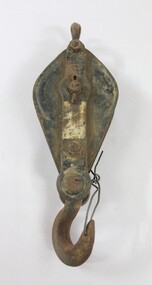 Wodonga & District Historical Society Inc
Functional object - Pulley, North East Region Water Authority, Wodonga
... drained and decommissioned after the No 1 Basin on Huon Hill was completed in 1958. In 1983 the Wodonga Waterworks Trust and the Wodonga Sewerage Authority became part of the Wodonga Council. And by 1989 a filtration plant at Huon Hill was completed, which provided filtered water of improved quality to Wodonga, in accordance with the World Health Organisation’s guidelines. In 1994 the Kiewa Murray Region Water Authority took over the Wodonga Council’s water and wastewater operations, and then in 1999 the Kiewa Murray Region Water Authority combined...drained and decommissioned after the No 1 Basin on Huon Hill was completed in 1958. In 1983 the Wodonga Waterworks Trust and the Wodonga Sewerage Authority became part of the Wodonga Council. And by 1989 a filtration plant at Huon Hill was completed, which provided filtered water of improved quality to Wodonga, in accordance with the World Health Organisation’s guidelines. In 1994 the Kiewa Murray Region Water Authority took over the Wodonga Council’s water and wastewater operations, and then in 1999 the Kiewa Murray Region Water Authority combined ...The pulley was used by the Wodonga Waterworks Trust and Sewerage Authority, which were established in 1897, and had the responsibility for providing Wodonga's drinking water and managing the wastewater. In 1923 a Wodonga Waterworks Trust referendum to provide funding for new infrastructure to supply more water of better quality to Wodonga was passed. This included building the Wodonga Water Tower and it was completed in 1924. It supplied water to Wodonga until 1959, when it was drained and decommissioned after the No 1 Basin on Huon Hill was completed in 1958. In 1983 the Wodonga Waterworks Trust and the Wodonga Sewerage Authority became part of the Wodonga Council. And by 1989 a filtration plant at Huon Hill was completed, which provided filtered water of improved quality to Wodonga, in accordance with the World Health Organisation’s guidelines. In 1994 the Kiewa Murray Region Water Authority took over the Wodonga Council’s water and wastewater operations, and then in 1999 the Kiewa Murray Region Water Authority combined with the Ovens Region Water Authority and became the North East Region Water Authority or NERWA. NERWA then became known as North East Water. The pulley has local significance due to its use by the Wodonga Waterworks Trust and Sewerage Authority, and donation from the North East Region Water Authority. It also has wider historical significance as an example of the equipment used in the early management of water in Victoria and Australia.Elongated ellipse-shaped iron pulley, painted black on the flat exterior surfaces. Considerable light brown dirt on the surface and traces of a silver coloured rectangular label on the central raised section on the front. The light brown surface dirt covers nearly the entire back surface. Piece of iron wire attached to the hook at the bottom of the pulley."Backwards R 6" on the central raised section on the back surface.wodonga waterworks trust, wodonga sewerage authority, wodonga water, pulleys, north east region water authority, north east water, n.e. water, nerwa -
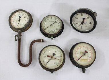 Wodonga & District Historical Society Inc
Functional object - Water Pump Pressure Gauges, North East Region Water Authority, Wodonga
... drained and decommissioned after the No 1 Basin on Huon Hill was completed in 1958. In 1983 the Wodonga Waterworks Trust and the Wodonga Sewerage Authority became part of the Wodonga Council. By 1989 a filtration plant at Huon Hill was completed, which provided filtered water of improved quality to Wodonga, in accordance with the World Health Organisation’s guidelines. In 1994 the Kiewa Murray Region Water Authority took over the Wodonga Council’s water and wastewater operations, and then in 1999 the Kiewa Murray Region Water Authority combined...drained and decommissioned after the No 1 Basin on Huon Hill was completed in 1958. In 1983 the Wodonga Waterworks Trust and the Wodonga Sewerage Authority became part of the Wodonga Council. By 1989 a filtration plant at Huon Hill was completed, which provided filtered water of improved quality to Wodonga, in accordance with the World Health Organisation’s guidelines. In 1994 the Kiewa Murray Region Water Authority took over the Wodonga Council’s water and wastewater operations, and then in 1999 the Kiewa Murray Region Water Authority combined ...The water pump pressure gauges were used by the Wodonga Waterworks Trust and Sewerage Authority, which were established in 1897, and had the responsibility for providing Wodonga's drinking water and managing the wastewater. In 1923 a Wodonga Waterworks Trust referendum to provide funding for new infrastructure to supply more water of better quality to Wodonga was passed. This included building the Wodonga Water Tower and it was completed in 1924. It supplied water to Wodonga until 1959, when it was drained and decommissioned after the No 1 Basin on Huon Hill was completed in 1958. In 1983 the Wodonga Waterworks Trust and the Wodonga Sewerage Authority became part of the Wodonga Council. By 1989 a filtration plant at Huon Hill was completed, which provided filtered water of improved quality to Wodonga, in accordance with the World Health Organisation’s guidelines. In 1994 the Kiewa Murray Region Water Authority took over the Wodonga Council’s water and wastewater operations, and then in 1999 the Kiewa Murray Region Water Authority combined with the Ovens Region Water Authority and became the North East Region Water Authority or NERWA. NERWA then became known as North East Water.The water pump pressure gauges have local significance due to their use by the Wodonga Waterworks Trust and Sewerage Authority, and donation from the North East Region Water Authority. They also have wider historical significance as examples of the equipment used in the management of water in Victoria and Australia.Five metal and glass water pump pressure gauges, including one with a U-shaped pipe and lever attached. "-HOMPSONS (CASTLEMAINE) LT-" on pressure gauge no.1 "BOURDON'S / PRESSURE GAUGE / THE AUSTRAL OTIS /ENGINEERING Co. LD. / MELBOURNE" on pressure gauge no.2 "No. 1609 / POUNDS PRESSURE / PER SQ. INCH / FEET HEAD OF WATER" on pressure gauge no. 3 "FEET HEAD OF WATER / THOMPSONS (CASTLEMAI-- LTD" on pressure gauge no. 4 "SET SLOW 33' -" / BUDENBERG / MADE IN AUSTRALIA / ft water / 1 4 9 3 9 each number underlined" on pressure gauge no. 5north east region water authority, nerwa, wodonga sewerage authority, north east water, n.e. water, wodonga waterworks trust, pressure gauges, water pump pressure gauges -
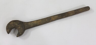 Wodonga & District Historical Society Inc
Tool - Large Spanner, North East Region Water Authority, Wodonga
... drained and decommissioned after the No 1 Basin on Huon Hill was completed in 1958. In 1983 the Wodonga Waterworks Trust and the Wodonga Sewerage Authority became part of the Wodonga Council. And by 1989 a filtration plant at Huon Hill was completed, which provided filtered water of improved quality to Wodonga, in accordance with the World Health Organisation’s guidelines. In 1994 the Kiewa Murray Region Water Authority took over the Wodonga Council’s water and wastewater operations, and then in 1999 the Kiewa Murray Region Water Authority combined...drained and decommissioned after the No 1 Basin on Huon Hill was completed in 1958. In 1983 the Wodonga Waterworks Trust and the Wodonga Sewerage Authority became part of the Wodonga Council. And by 1989 a filtration plant at Huon Hill was completed, which provided filtered water of improved quality to Wodonga, in accordance with the World Health Organisation’s guidelines. In 1994 the Kiewa Murray Region Water Authority took over the Wodonga Council’s water and wastewater operations, and then in 1999 the Kiewa Murray Region Water Authority combined ...The large wrench was used by the Wodonga Waterworks Trust and Sewerage Authority, which were established in 1897, and had the responsibility for providing Wodonga's drinking water and managing the wastewater. In 1923 a Wodonga Waterworks Trust referendum to provide funding for new infrastructure to supply more water of better quality to Wodonga was passed. This included building the Wodonga Water Tower and it was completed in 1924. It supplied water to Wodonga until 1959, when it was drained and decommissioned after the No 1 Basin on Huon Hill was completed in 1958. In 1983 the Wodonga Waterworks Trust and the Wodonga Sewerage Authority became part of the Wodonga Council. And by 1989 a filtration plant at Huon Hill was completed, which provided filtered water of improved quality to Wodonga, in accordance with the World Health Organisation’s guidelines. In 1994 the Kiewa Murray Region Water Authority took over the Wodonga Council’s water and wastewater operations, and then in 1999 the Kiewa Murray Region Water Authority combined with the Ovens Region Water Authority and became the North East Region Water Authority or NERWA. NERWA then became known as North East Water. The large spanner has local significance due to its use by the Wodonga Waterworks Trust and Sewerage Authority, and donation from the North East Region Water Authority. It also has wider historical significance as an example of the equipment used in the management of water in Victoria and Australia.Large cast iron spanner with some red/brown rust corrosion and light brown ingrained surface dirt.north east region water authority, nerwa, wodonga sewerage authority, north east water, n.e. water, wodonga, large spanners, spanner, wodonga waterworks trust -
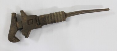 Wodonga & District Historical Society Inc
Tool - Shifter Wrench, North East Region Water Authority, Wodonga
... drained and decommissioned after the No 1 Basin on Huon Hill was completed in 1958. In 1983 the Wodonga Waterworks Trust and the Wodonga Sewerage Authority became part of the Wodonga Council. And by 1989 a filtration plant at Huon Hill was completed, which provided filtered water of improved quality to Wodonga, in accordance with the World Health Organisation’s guidelines. In 1994 the Kiewa Murray Region Water Authority took over the Wodonga Council’s water and wastewater operations, and then in 1999 the Kiewa Murray Region Water Authority combined...drained and decommissioned after the No 1 Basin on Huon Hill was completed in 1958. In 1983 the Wodonga Waterworks Trust and the Wodonga Sewerage Authority became part of the Wodonga Council. And by 1989 a filtration plant at Huon Hill was completed, which provided filtered water of improved quality to Wodonga, in accordance with the World Health Organisation’s guidelines. In 1994 the Kiewa Murray Region Water Authority took over the Wodonga Council’s water and wastewater operations, and then in 1999 the Kiewa Murray Region Water Authority combined ...The Shifter Wrench was used by the Wodonga Waterworks Trust and Sewerage Authority, which were established in 1897, and had the responsibility for providing Wodonga's drinking water and managing the wastewater. In 1923 a Wodonga Waterworks Trust referendum to provide funding for new infrastructure to supply more water of better quality to Wodonga was passed. This included building the Wodonga Water Tower and it was completed in 1924. It supplied water to Wodonga until 1959, when it was drained and decommissioned after the No 1 Basin on Huon Hill was completed in 1958. In 1983 the Wodonga Waterworks Trust and the Wodonga Sewerage Authority became part of the Wodonga Council. And by 1989 a filtration plant at Huon Hill was completed, which provided filtered water of improved quality to Wodonga, in accordance with the World Health Organisation’s guidelines. In 1994 the Kiewa Murray Region Water Authority took over the Wodonga Council’s water and wastewater operations, and then in 1999 the Kiewa Murray Region Water Authority combined with the Ovens Region Water Authority and became the North East Region Water Authority or NERWA. NERWA then became known as North East Water. The shifter wrench has local significance due to its use by the Wodonga Waterworks Trust and Sewerage Authority, and donation from the North East Region Water Authority. It also has wider historical significance as an example of the equipment used in the early management of water in Victoria and Australia.Large cast iron wrench with an adjustable grip and a circular turning mechanism at the top of a thin tapering handle. 2.6 cm thread on the end of the thin tapering handle. "GSP 23/15" on one side of the thin tapering handle.north east region water authority, nerwa, wodonga sewerage authority, north east water, n.e. water, wodonga, shifter wrench, wodonga waterworks trust -
 Melton City Libraries
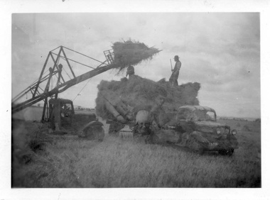
Photograph, Harvesting, 1950
... draining of water if rain had occurred. Prior to the invention of the mechanical hayfork this was a laborious task requiring each sheaf to be pitched onto a tray truck and moved to the location of the haystack. The mechanised HAYFORK was operated by one person on tractor greatly reducing the need for gangs of labourers. At harvest time farmers had relied on itinerant teams of workers descending on the district looking for work. The three Barrie brothers on their adjoining farms combined...draining of water if rain had occurred. Prior to the invention of the mechanical hayfork this was a laborious task requiring each sheaf to be pitched onto a tray truck and moved to the location of the haystack. The mechanised HAYFORK was operated by one person on tractor greatly reducing the need for gangs of labourers. At harvest time farmers had relied on itinerant teams of workers descending on the district looking for work. The three Barrie brothers on their adjoining farms combined ...1950 decade HAY FORK - A local invention. Bill and Arthur Gillespie and Bon Barrie In the early 1950’s Bill Gillespie of Bulmans Lane had been experimenting in developing a machine to improve the collection of hay sheaves at harvesting and stack building time. The ripened crop was cut by a reaper and binder which bundled the storks into sheaves tied with binder twine. The reaper and binder was towed by a tractor by the mid 1940s previously teams of draught horses were used to pull the reaper and binder. A photograph taken at the Barrie farm shows three binders the first being towed with a tractor and the others with horse teams. Two workmen were needed to operate the binder when cutting a crop. The sheaves collected on the binder and released onto the ground and were scattered across the paddocks. Using a conventional two pronged pitch fork the harvest hands collected the sheaves and placed each one cut edge on the ground in an upright position and layered with about 15 sheaves into an apex shape to form was is known as a stook. The shape of the stook allowed for drying and draining of water if rain had occurred. Prior to the invention of the mechanical hayfork this was a laborious task requiring each sheaf to be pitched onto a tray truck and moved to the location of the haystack. The mechanised HAYFORK was operated by one person on tractor greatly reducing the need for gangs of labourers. At harvest time farmers had relied on itinerant teams of workers descending on the district looking for work. The three Barrie brothers on their adjoining farms combined forces to cut their crop at its optimum time while the weather was in their favour. Up to many 20 workers at times formed a team in earlier times. Agricultural university students were also keen to gain practical experience in the field. Each of the brothers had a particular skill, and Tom Barrie was the expert on stack building. The district haystacks had a distinctive shape and could be recognised by their builder. Bill Gillespie’s first operational HAY FORK consisted of a large 13 pronged fork situated forward of the truck cabin. It was attached with iron girders and mounted on the rear of the cabin to the tray of his British Bedford truck. It was constructed in metal and iron and welded in the farmers work sheds. The mechanism was raised and lowered by the driver scooping along the ground to pick up a complete stook to raise high enough to deposit all the sheaves in one stook onto the stack or truck tray. The fork section was released by a rope and operated by the driver in the cabin. This model was trialled on the Barrie farm at Ferris Lane. It proved to be very successful and the Barrie/ Gillespie brothers went on to develop a HAYFORK which attached to a tractor and was operated with a series of levers and was raised and lowered hydraulically. It was detached from the tractor when stacking was completed. In its early days farmers travelling along the Western Highway called at the Barrie farm at Ferris Lane to inspect its construction and operation of the invention. It became a widely adopted by farmers throughout the State. It was being used on Wattie Palmer’s farm on Bridge Road Melton South in 1997. Farming in Melton, hay growing and stack building. agriculture, local identities -
City of Kingston
Photograph - Colour, Circa 1993
... combined with mid-century housing and newer homes. The large blocks are increasingly subdivided and the existing dwellings demolished to accommodate units and townhouses, thus changing the landscape of the area and reducing the tree canopy. The beachside suburb of Edithvale was previously part of the extensive Carrum Carrum Swamp. The area was once a source of fish and eels for the Mayone-Bulluk clan of the Bunurong people. Over time the area was drained ...Edithvale is a suburb in the City of Kingston. It is located between Aspendale and Chelsea on the Port Phillip Bay and built within remnant areas of the Carrum Carrum swamp. The foreshore precinct comprises a wide sandy beach, with low sand dunes and numerous historic boat sheds. The suburb consists of older style dwellings and former holiday houses, combined with mid-century housing and newer homes. The large blocks are increasingly subdivided and the existing dwellings demolished to accommodate units and townhouses, thus changing the landscape of the area and reducing the tree canopy.The beachside suburb of Edithvale was previously part of the extensive Carrum Carrum Swamp. The area was once a source of fish and eels for the Mayone-Bulluk clan of the Bunurong people. Over time the area was drained and predominantly devoted to dairy farming and holiday houses. The farms were gradually sold and subdivided with a large number of homes built after World War II and in the 1960s. Edithvale is mainly residential with a shopping strip along Nepean Highway but little significant industry was ever established in the area apart from a plaster works and confectionary factory, both now closed.Aerial colour photograph of Edithvale as viewed from Alexandra Avenue in the north to Ella Grove Chelsea/Edithvale in the south. The area is built-up with residential housing and facilities including Edithvale Primary School, numerous churches and the Edithvale Railway station. Large sections depict the remnant Carrum Carrum swamp. Edithvale Common and the former "Duck Inn" (Melbourne Water/Friends of Edithvale Seaford Wetlands) can be seen. Edithvale Recreational reserve, the velodrome and Edithvale Public Golf Course are prominent. The image shows vacant land in the area now known as Aspendale Gardens and the newer residential section of Chelsea Heights is not developed. A bike path has been established to cover the secondary drain. The Golf Links Court residential development located off Hughes Avenue is a large vacant block.Yellow circular adhesive sticker on plastic Black ink (marker): * (asterisk) Black type on white adhesive sticker: P000108edithvale, aspendale, chelsea, carrum carrum swamp -
City of Kingston
Photograph - Colour, 6 March 1993
... combined with mid-century housing and newer homes. The large blocks are increasingly subdivided and the existing dwellings demolished to accommodate units and townhouses, thus changing the landscape of the area and reducing the tree canopy. The beachside suburb of Edithvale was previously part of the extensive Carrum Carrum Swamp. The area was once a source of fish and eels for the Mayone-Bulluk clan of the Bunurong people. Over time the area was drained ...Edithvale is a suburb in the City of Kingston. It is located between Aspendale and Chelsea on the Port Phillip Bay and built within remnant areas of the Carrum Carrum swamp. The foreshore precinct comprises a wide sandy beach, with low sand dunes and numerous historic boat sheds. The suburb consists of older style dwellings and former holiday houses, combined with mid-century housing and newer homes. The large blocks are increasingly subdivided and the existing dwellings demolished to accommodate units and townhouses, thus changing the landscape of the area and reducing the tree canopy.The beachside suburb of Edithvale was previously part of the extensive Carrum Carrum Swamp. The area was once a source of fish and eels for the Mayone-Bulluk clan of the Bunurong people. Over time the area was drained and predominantly devoted to dairy farming and holiday houses. The farms were gradually sold and subdivided with a large number of homes built after World War II and in the 1960s. Edithvale is mainly residential with a shopping strip along Nepean Highway but little significant industry was ever established in the area apart from a plaster works and confectionary factory, both now closed.Laminated aerial colour photograph of Edithvale as viewed from Alexandra Avenue in the north to Ella Grove Chelsea/Edithvale in the south. regents Park Aspendale can be seen in the top left. The area is built-up with residential housing and facilities including Edithvale Primary School, numerous churches and the Edithvale Railway station. Large sections depict the remnant Carrum Carrum swamp. Edithvale Common and the former "Duck Inn" (Melbourne Water/Friends of Edithvale Seaford Wetlands) can be seen. Edithvale Recreational reserve, the valodrome and Edithvale Public Golf Course are prominent. The image shows vacant land in the area now known as Aspendale Gardens and the newer residential section of Chelsea Heights is not developed. A bike path has been established to cover the secondary drain. The Golf Links Court residential development located off Hughes Avenue is a large vacant block.Black type on white adhesive label: 6-3-93 Black type on white adhesive label: 25/9211, 6/3/93, 11.20 am Black type on white adhesive label: 9211 Yellow circular adhesive sticker Black pencil: 9211 6-3-93 arrow pointing Nedthvale, carrum carrum swamp, aspendale, chelsea