Showing 23 items matching "compass raaf"
-
 Moorabbin Air Museum
Book (Item) - RAAF Compass Log Aircraft A84-222
... RAAF Compass Log Aircraft A84-222...RAAF Compass Log Aircraft A84-222...Moorabbin Air Museum Moorabbin Airport 12 First Street Moorabbin melbourne RAAF Compass Log Aircraft A84-222 Book RAAF Compass Log Aircraft A84-222 ... -
Moorabbin Air Museum
Manual (Item) - De Havilland Mosquito Mk.41 Aeroplane Maintenance Form logs Sqn 87 & RAAF Compass Log A52-352
... De Havilland Mosquito Mk.41 Aeroplane Maintenance Form logs Sqn 87 & RAAF Compass Log A52-352...De Havilland Mosquito Mk.41 Aeroplane Maintenance Form logs Sqn 87 & RAAF Compass Log A52-352...Moorabbin Air Museum Moorabbin Airport 12 First Street Moorabbin melbourne De Havilland Mosquito Mk.41 Aeroplane Maintenance Form logs Sqn 87 & RAAF Compass Log A52-352 Manual De Havilland Mosquito Mk.41 Aeroplane Maintenance Form logs Sqn 87 & RAAF Compass Log A52-352 ... -
Moorabbin Air Museum
Book (Item) - RAAF - Compass Log For GAF Mirage A3-45
... RAAF - Compass Log For GAF Mirage A3-45...RAAF - Compass Log For GAF Mirage A3-45...Moorabbin Air Museum Moorabbin Airport 12 First Street Moorabbin melbourne RAAF - Compass Log For GAF Mirage A3-45 Book RAAF - Compass Log For GAF Mirage A3-45 ... -
Moorabbin Air Museum
Document (Item) - RAAF - Gyrosyn Compass System Type C - 14 Sperry
... RAAF - Gyrosyn Compass System Type C - 14 Sperry...RAAF - Gyrosyn Compass System Type C - 14 Sperry...Moorabbin Air Museum Moorabbin Airport 12 First Street Moorabbin melbourne AAP 7521.040-3M RAAF - Gyrosyn Compass System Type C - 14 Sperry Document RAAF - Gyrosyn Compass System Type C - 14 Sperry ...AAP 7521.040-3M -
 Bendigo Military Museum
Equipment - COMPASSES, RAAF, C.1939 - 45
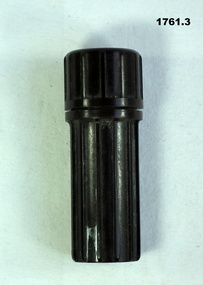
... Compass RAAF...Refer Cat No 1760.4. Compass RAAF emergency equipment A bakelite cylindrical container with an emergency compass. ...Item belonged to Victor Henry Evans No 418655 RAAF. Refer Cat No 1760.4. A bakelite cylindrical container with an emergency compass. Inside the screw on lid another compass loose inside the container. .1) cylinder. .2) lid. .3) second compass.compass raaf, emergency, equipment -
Moorabbin Air Museum
Manual (Item) - RAAF Compass Log
... RAAF Compass Log...AAP 7291.021-2M (-1, -2, -6) Level of Importance: World. Manual RAAF Compass Log ...Description: 190 pages. Published by RAAF. Published 22/4/1982. AAP 7291.021-2M (-1, -2, -6) Level of Importance: World. -
Moorabbin Air Museum
Manual (Item) - RAAF Gyrosyn Compass Manual, Royal Australian Air Force Gyrosyn Compass Type CL11K
... RAAF Gyrosyn Compass Manual ...Moorabbin Air Museum Moorabbin Airport 12 First Street Moorabbin melbourne RAAF Royal Australian Air Force Gyrosyn Compass Type CL11K Manual RAAF Gyrosyn Compass Manual ...RAAF -
Frankston RSL Sub Branch
Compass, Astro
... compass...navigation...aeronautical...raaf...Frankston RSL Sub Branch 183 Cranbourne Road Frankston mornington-peninsula compass astro compass navigation aeronautical raaf raf ww2 Nameplate on the base reads "ASTRO-COMPASS MK II / The W.W. ...A World War 2 era W. W. Boes and Co. MKll astro compass typically used as an aviation navigation aid. It is manufactured from aluminum with black enamel finish. An astro compass is a navigational tool used to determine true north from the position of the sun or astronomical bodies. These are used in circumstances where magnetic compasses and gyrocompasses are unreliable, for example in the presence of magnetic field anomalies (such as polar regions, ships hulls, aircraft hulls, etc.). Nameplate on the base reads "ASTRO-COMPASS MK II / The W.W. BOES CO. / DAYTON, OHIO, USA"compass, astro compass, navigation, aeronautical, raaf, raf, ww2, -
 Bendigo Military Museum
Map - RASvy " Map Makers Exhibition 2025 "- Map display, RAN Hydrographic Office, 1972 - 1992
... RAAF flights. Of Particular note these charts were used to plot "Rhumb Lines or loxodromes" where a course crosses all Meridians (Lines of latitude and longitude) at the same angle. On Mercator projection charts Rhumb lines are conveniently shown as straight lines and are also lines of constant compass bearing. ...RAAF flights. Of Particular note these charts were used to plot "Rhumb Lines or loxodromes" where a course crosses all Meridians (Lines of latitude and longitude) at the same angle. On Mercator projection charts Rhumb lines are conveniently shown as straight lines and are also lines of constant compass bearing. ...All of these Charts / Maps were used for the RSL Museum display " The Mapmakers " ( of RASvy. ) 10 Jun - 10 Aug 2025. .1 Catalogue of Tactical Pilotage Charts, 1:500 000 Scale. Digital Data Base available as at 30Jun 92. This catalogue page shows the extent of the Australian area of responsibility for aeronautical charting. .2 RAAF PLOTTING CHART. NP 22-2 (Navigational Plotting) Tasmania. MERCATOR PROJECTION. This series of charts were used for the training of RAAF Navigators. These charts were produced and printed at the Army Survey Regiment, Bendigo. .3 RAAF PLOTTING CHART AUSTRALIA - SOUTHEAST. NP 27 is Based on LAMBERT CONFORMAL CONIC PROJECTION. This series of charts was used by RAAF Navigators for the planning of RAAF flights. These charts were produced and printed at the Army Survey Regiment, Bendigo. .4 RAAF LONG RANGE PLOTTING CHART. NP 43-4 AUSTRALIA WESTERN. MERCATOR PROJECTION. This series of maps were used for the planning of RAAF flights. Of Particular note these charts were used to plot "Rhumb Lines or loxodromes" where a course crosses all Meridians (Lines of latitude and longitude) at the same angle. On Mercator projection charts Rhumb lines are conveniently shown as straight lines and are also lines of constant compass bearing. Rhumb lines are usually longer than the shortest distance between two points. The shortest distance between two points on the earth's surface is called a "Great Circle Route" which is a route on a circular path on the surface of the earth where the centre of that circle is also the centre of the earth. Great Circle Routes on a Mercator Projection are however curves and harder to plot. These charts were produced and printed at the Army Survey Regiment, Bendigo. .5 RAAF LONG RANGE PLOTTING CHART. NP 43-7 SOLOMON ISLANDS. MERCATOR PROJECTION. Used for the planning of RAAF flights. .6 RAAF AIR STAFF PLANNING CHART NS 137-1 DARWIN NORTH WEST. AZIMUTHAL EQUIDISTANT PROJECTION. This series of charts were used for planning by the staff. The whole chart was produced by joining the four quadrant maps together. The charts are based on a single point of tangency (in this case Darwin) and shows radius (distance) in nautical miles to and from that point. A series of charts were produced centred on each of the major airfields in Northern Australia. These charts were produced and printed at the Army Survey Regiment, Bendigo. .7 RAAF AIR STAFF PLANNING CHART NS 137-2 DARWIN NORTH EAST. AZIMUTHAL EQUIDISTANT PROJECTION. Used for the planning by the staff. The charts are based on a point of tangency and show radius in nautical miles. .8 RAAF AIR STAFF PLANNING CHART NS 137-4 DARWIN SOUTH WEST. AZIMUTHAL EQUIDISTANT PROJECTION. Used for the planning by the staff. The charts are based on a point of tangency and show radius in nautical miles. .9 RAAF AIR STAFF PLANNING CHART NS 137-3 DARWIN SOUTH EAST. AZIMUTHAL EQUIDISTANT PROJECTION. Used for the planning by the staff. The charts are based on a point of tangency and show radius in nautical miles. .10 TACTICAL PILOTAGE CHART. TPC R-13B. LAMBERT CONFORMAL PROJECTION. Used by pilots for flight planning and could be used in flight if necessary for visual navigation using major ground features shown on the chart. These charts also contained aeronautical information such as airfields, radio navigation beacons and obstructions. Contours and height information was shown in feet to be compatible with aircraft altimeters. Each graticule square also contained a Maximum Safe Elevation Figure (MEF) also in feet. Coverage of this series over Australia's area of interest were produced and printed at the Army Survey Regiment, Bendigo. .11 HYDROGRAPHIC CHART. AUS 158. PORT PHILLIP SOUTH and WEST CHANNELS. PROJECTION TRANSVERSE MERCATOR. Used by all people needing to navigate a vessel. Hydrographic charts were printed at the Army Survey Regiment, Bendigo. .12 HYDROGRAPHIC CHART. AUS 157. GEELONG HARBOUR and APPROACHES. PROJECTION TRANSVERSE MERCATOR. Used by all people needing to navigate a vessel. .13 EN ROUTE CHART. AUSTRALIA ERC HIGH. H1 and H2. LAMBERT CONFORMAL CONIC PROJECTION. This series of charts were regularly produced by the RAAF Aeronautical Information Service (AIS) and contained current aeronautical information for pilots. These charts were printed at the Army Survey Regiment, Bendigo..1 Tactical Pilotage Chart Series Catalogue. Current as at 30 Jun 92. .2 Extract of Navigational Plotting Chart " NP22-2 Tasmania " .3 Extract of Navigational Plotting Chart " NP 27 RAAF PLOTTING CHART AUSTRALIA - SOUTHEAST " .4 Extract of Navigational Plotting Chart " RAAF LONG RANGE PLOTTING CHART NP43-4 AUSTRALIA WESTERN " .5 Extract of Navigational Plotting Chart " RAAF LONG RANGE PLOTTING CHART NP43-7 SOLOMON ISLANDS " .6 Extract of Navigational Series " RAAF AIR STAFF PLANNING CHART NS 137-2 DARWIN NORTH WEST " .7 Extract of Navigational Series " RAAF AIR STAFF PLANNING CHART NS 137-1 DARWIN NORTH EAST " .8 Extract of Navigational Series " RAAF AIR STAFF PLANNING CHART NS 137-4 DARWIN SOUTH WEST " .9 Extract of Navigational Series " RAAF AIR STAFF PLANNING CHART NS 137-3 DARWIN SOUTH EAST " .10 Extract of Tactical Pilotage Chart " TPC R-13B " .11 Extract of Hydrographic Chart " PORT PHILLIP SOUTH and WEST CHANNELS " .12 Extract of Hydrographic Chart " GEELONG HARBOUR and APPROACHES " .13 Extract of En Route Chart " AUSTRALIA ERC HIGH " " H1 and H2 " royal australian survey corps, rasvy, fortuna, detachment - army survey regiment, army svy regt, asr -
 Bendigo Military Museum
Map - MAP of LONDON, The Authentic Map of London
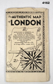
... RAAF. Refer cCat No 3536P for his service details. map london Black and white folded street map with transport routes/stations marked in orange. Cover is black and white print, features a scroll and compass ...Map of London with also places of interest. Part of th collection of Frederick Gardner Davey DFC No 410533 RAAF. Refer cCat No 3536P for his service details.Black and white folded street map with transport routes/stations marked in orange. Cover is black and white print, features a scroll and compass design inside a B & W border, written details in black type, street index printed on inside of the cover.map, london -
 Bendigo Military Museum
Equipment - THEODOLITE, c.1930 - 1940
... RAAF. Refer Cat No1959 for his service history. The two items were put together to make a home made Theodolite. surveying-terrestrial compass "AM ASTRO Compass MKII Ref 6A/1174 3.C" Metal, glass construction consisting of an eye piece from a bomb sight eye piece with several adjustments fitted to an ASTRO Compass MKII and rotates on a base Equipment THEODOLITE ...Item belonged to Maxwell Lennox MATHESON 418447 RAAF. Refer Cat No1959 for his service history. The two items were put together to make a home made Theodolite.Metal, glass construction consisting of an eye piece from a bomb sight eye piece with several adjustments fitted to an ASTRO Compass MKII and rotates on a base"AM ASTRO Compass MKII Ref 6A/1174 3.C"surveying-terrestrial, compass -
 Bendigo Military Museum
Equipment - WEBBING BELT/POUCH, C. 1939-45
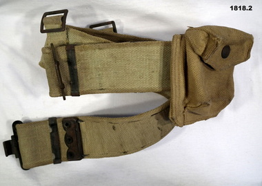
... Refer also 1817. uniforms airforce Webbing .1) "144278 RAAF" .1) Webbing Belt, Khaki, adjustable with brass buckles and loops, rear of belt has two webbing loops with brass buckles .2) Compass pouch with a brass stud also two brass loops on the rear. ...The belt and pouch issued to John Charles Dean No 144278 RAAF, enlisted 26.8.43 age 18 years. On discharge from the RAAF he was an LAC in 78 Sqd RAAF. Refer also 1817..1) Webbing Belt, Khaki, adjustable with brass buckles and loops, rear of belt has two webbing loops with brass buckles .2) Compass pouch with a brass stud also two brass loops on the rear..1) "144278 RAAF"uniforms airforce, webbing -
 Bendigo Military Museum
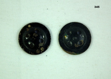
Equipment - BUTTON COMPASS
... The compass belonged to Arthur COWLEY No 50704, RAAF. Refer Cat No 354.5 for his service details....Bendigo Military Museum 37 - 39 Pall Mall Bendigo goldfields The compass belonged to Arthur COWLEY No 50704, RAAF. Refer Cat No 354.5 for his service details. compass accessory ww2 Two Piece system. ...The compass belonged to Arthur COWLEY No 50704, RAAF. Refer Cat No 354.5 for his service details.Two Piece system. One Button is set into the other to form a Survival Compasscompass, accessory, ww2 -
Running Rabbits Military Museum operated by the Upwey Belgrave RSL Sub Branch
Survival Compass
... Equipment WW2 RAAF Minature compass in waterproof container with lanyard X (2) Survival Compass ...Part of a pilot's survival kit.Minature compass in waterproof container with lanyard X (2)equipment, ww2, raaf -
Running Rabbits Military Museum operated by the Upwey Belgrave RSL Sub Branch
Minature Compass
... Equipment WW2 RAAF Minature Compass X (2) Minature Compass ...Part of a pilot's survival kit.Minature Compass X (2)equipment, ww2, raaf -
Running Rabbits Military Museum operated by the Upwey Belgrave RSL Sub Branch
Emergency Compass Parts
... Equipment WW2 RAAF BrassSpindles X 8, 4 Prs of Magnetised Needles and 2 corks Emergency Compass Parts ...Part of a survival kit.BrassSpindles X 8, 4 Prs of Magnetised Needles and 2 corksequipment, ww2, raaf -
 B-24 Liberator Memorial Restoration Australia Inc
Aviation Compass, Aircraft Compass
... B-24 Liberator Memorial Restoration Australia Inc Corner Farm Rd & Princes Highway Werribee melbourne Used on RAAF aircraft in WWII Used by RAAF for navigation training primarily in Tiger Moth and Spitfire aircraft. aviation compass a6 Number 80873.D Brass Plate - King's Crown over RAAF No. ...Used on RAAF aircraft in WWIIUsed by RAAF for navigation training primarily in Tiger Moth and Spitfire aircraft.Navigation Compass Type P8. Number 80873.D Brass Plate - King's Crown over RAAF No. G6A/726aviation compass, a6 -
 Ringwood RSL Sub-Branch
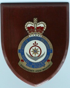
Plaque - Shield - RAAF 13 Squadron, City of Darwin Squadron, Circa 2000
... Motto - Resilient and Ready Wooden shield with plastic badge- QE2 crown with northern compass and buffalo horns City of Darwin Squadron Plaque Shield - RAAF 13 Squadron Quai Kee ...Wooden shield with plastic badge- QE2 crown with northern compass and buffalo hornsCity of Darwin Squadron - Royal Australian Airforce. Motto - Resilient and Ready -
 Moorabbin Air Museum
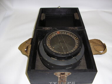
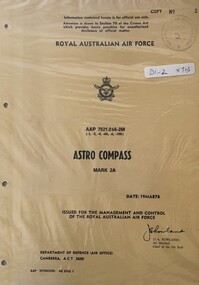
Manual (Item) - (SP) AAP 7521.066-2M Astro Compass Mk 2A
... Moorabbin Air Museum Moorabbin Airport 12 First Street Moorabbin melbourne RAAF Manual (SP) AAP 7521.066-2M Astro Compass Mk 2A ...RAAF -
Moorabbin Air Museum
Manual (Item) - RAAF Basic Navigation Course - Compasses. TG-48 Volume 4
... Moorabbin Air Museum Moorabbin Airport 12 First Street Moorabbin melbourne RAAF Basic Navigation Course - Compasses. TG-48 Volume 4 Manual RAAF Basic Navigation Course - Compasses. ... -
Moorabbin Air Museum
Manual (Item) - RAAF - With Map And Compass TG-74
... RAAF - With Map And Compass TG-74...RAAF - With Map And Compass TG-74...Moorabbin Air Museum Moorabbin Airport 12 First Street Moorabbin melbourne RAAF - With Map And Compass TG-74 Manual RAAF - With Map And Compass TG-74 ... -
Moorabbin Air Museum
Manual (Item) - RAAF Training Guide - Basic Navigation Course Compasses TG-48-4
... Moorabbin Air Museum Moorabbin Airport 12 First Street Moorabbin melbourne RAAF Training Guide - Basic Navigation Course Compasses TG-48-4 Manual RAAF Training Guide - Basic Navigation Course Compasses TG-48-4 ... -
Moorabbin Air Museum
Book (Item) - RAAF School Of Technical Training Basic And Magnetic Compass Theory
... RAAF School Of Technical Training Basic And Magnetic Compass Theory...RAAF School Of Technical Training Basic And Magnetic Compass Theory...Moorabbin Air Museum Moorabbin Airport 12 First Street Moorabbin melbourne RAAF School Of Technical Training Basic And Magnetic Compass Theory Book RAAF School Of Technical Training Basic And Magnetic Compass Theory ...