Showing 7 items matching "computing scale"
-
 Flagstaff Hill Maritime Museum and Village
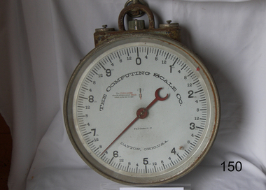
Instrument - Scale, Computing Scale Company, 1897-1900
... ...computing scale...In 1885 Julius Pitrat of Gallipolis, Ohio, patented the first computing scale. Six years later, Edward Canby and Orange Ozias of Dayton, Ohio, purchased Pitrat's patents and incorporated The Computing Scale Company as the world's first computing scale vendor. ...Ring on the top for mounting. Marked "The Computing Scale Co Dayton Ohio"...Marked "The Computing Scale Co Dayton Ohio"...Computing Scale Company...Ring on the top for mounting. Marked "The Computing Scale Co Dayton Ohio" Instrument Scale Computing Scale Company ...In 1885 Julius Pitrat of Gallipolis, Ohio, patented the first computing scale. Six years later, Edward Canby and Orange Ozias of Dayton, Ohio, purchased Pitrat's patents and incorporated The Computing Scale Company as the world's first computing scale vendor. And four years after that, The Computing Scale Company introduced the first automatic computing scale In 1911. the Computing Scale Company merged with the International Time Recording Company and Tabulating Machine Company to form the Computing-Tabulating-Recording Company, a business that was renamed IBM in 1924. An early example of a hanging clock face scale patented in October 1897 and made by a company that pioneered the first computing scales used in retail businesses. This company went on to become incorporated with IBM that late became an international computer manufacturer.Scale, patented Oct 12, 1897. Measures in pounds and ounces, up to 10lb. Red indicator needle. Two adjustment screws. Ring on the top for mounting. Marked "The Computing Scale Co Dayton Ohio"Marked "The Computing Scale Co Dayton Ohio"flagstaff hill, warrnambool, shipwrecked coast, flagstaff hill maritime museum, maritime museum, shipwreck coast, flagstaff hill maritime village, great ocean road, scale, computing scale, computing scale company, weighing instrument -
 City of Moorabbin Historical Society (Operating the Box Cottage Museum)
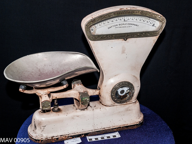
Scales, Shop,Imperial, ‘Dayton Scale’, c1900
... ...computing scale company ohio...The Dayton Scale Company, originally known as the Computing Scale Company, built and marketed the first computing scale in 1891. ...In window of glass framed gauge ; DAYTON SCALE CO. / OHIO USA ; Computed from 0 – 2LB in 1oz sections ...The Dayton Scale Company, originally known as the Computing Scale Company, built and marketed the first computing scale in 1891. ...This 'Dayton Scale' was used in a grocery shop in Moorabbin Shire in 20thC to measure grain, sugar, fruit, vegetables, lollies, etc as required by the shopkeeper for the purchase by customers. The Dayton Scale Company, originally known as the Computing Scale Company, built and marketed the first computing scale in 1891. It was part of the Computing-Tabulating-Recording Company formed in 1911, and became an IBM division in 1933. The Dayton Scale Division was eventually sold to the Hobart Manufacturing Company when IBM decided to stop marketing scales to retail stores. The Computing Scale Company of Dayton was operated from 1891-1914 by two businessmen from Dayton, Ohio who purchased patents on the recently invented computing scale. It was merged with other companies to become the forerunner company for IBM. On July 20 1897 Mr CC Hobart & Herbert L. Johnson formed the Hobart Electrical Manufacturing Company in Troy, Ohio USA. 1915 Hobart continues its growth into the World market, opening a sales office in Australia. Dayton grocery scales, capacity 2 pounds, Imperial Measure. It is made from white painted steel with a large metal scoop that sits on 2 steel rods attached to a balance beam connected to a recording mechanism that displays the ‘weight’ in a glass framed gauge. In window of glass framed gauge ; DAYTON SCALE CO. / OHIO USA ; Computed from 0 – 2LB in 1oz sections weights, measures, shops, scales. balances, grocery stores, early settlers, moorabbin, bentleigh, cheltenham, dayton scales company, ibm pty ltd., hobarrt electrical manufacturing company, hobart c.c., johnson herbert l, computing scale company ohio -
 Clunes Museum
Equipment - BUTCHER SCALES
... MANUFACTURED BY THE COMPUTING SCALE CO. DAYTON, O. USA. HAS A CRADLE FOR THE TRAY TO WEIGH ITEMS AND A FLAT SPACE FOR THE WEIGHTS. .2 10 METAL PRICE TAGS WITH SPIKES. ...THE COMPUTING SCALE CO. DAYTON, O. USA...COMMERCE BUTCHER SCALES ROD SPARKS THE COMPUTING SCALE CO. DAYTON, O. USA .1 METAL BUTCHER'S SCALES. ....1 METAL BUTCHER'S SCALES. MANUFACTURED BY THE COMPUTING SCALE CO. DAYTON, O. USA. HAS A CRADLE FOR THE TRAY TO WEIGH ITEMS AND A FLAT SPACE FOR THE WEIGHTS. .2 10 METAL PRICE TAGS WITH SPIKES. EACH TAG IS HEART SHAPED, PAINTED CREAM WITH NUMBERS PAINTED FRONT AND BACK. 1, 1 1/2; 2D, 2 1/2 (2 OF); 3D, 3 1/2 (2 OF); 4D, 4 1/2 (2 OF); 5D, 5 1/2; 7, 7 1/2; 8, 8 1/2. .3 WEIGHING TRAY. OVAL SHAPED AND PAINTED CREAM. .4 ROUND CAST IRON WEIGHT.THE COMPUTING SCALE CO. DAYTON, O. USAcommerce, butcher scales, rod sparks -
Clunes Museum
Functional object - MEAT SCALES
... THE COMPUTING SCALE. CO. DAYTON. OHIO U.S.A. - SERIAL NO. 582992...LOCAL HISTORY COMMERCE SHOP EQUIPMENT SCALES SHOP EQUIPMENT. THE COMPUTING SCALE. CO. DAYTON. OHIO U.S.A. - SERIAL NO. 582992 DAYTON BARREL SCALES. ...USED BY MR. LOWNE IN HIS BUTCHER SHOP IN SERVICE STREET CLUNES.DAYTON BARREL SCALES. USED BY MR. R. LOWNE IN BUTCHER SHOP, SERVICE STREET, CLUNES, UNTIL METRIC WAS INTRODUCED. HAS PORCELAIN PLATE, ON WHICH THE MEAT WAS PLACED FOR WEIGHING.THE COMPUTING SCALE. CO. DAYTON. OHIO U.S.A. - SERIAL NO. 582992local history, commerce, shop equipment, scales, shop equipment. -
 Bendigo Military Museum
Photograph - RA Svy Project C4 Aerodist Operation, Eastern Arnhem Land, NT, 1967
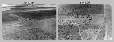
... computed. Aerodist MRC2 was RA Svy’s major horizontal control survey tool for mainly medium scale topographic mapping (scale 1:100,000 Class A being spatially accurate to within 50 metres) in PNG, northern NT, north-west WA, Kalimantan Barat (West) Indonesia, Sumatra Indonesia, Gulf of Carpentaria and Cape York, QLD. ...computed. Aerodist MRC2 was RA Svy’s major horizontal control survey tool for mainly medium scale topographic mapping (scale 1:100,000 Class A being spatially accurate to within 50 metres) in PNG, northern NT, north-west WA, Kalimantan Barat (West) Indonesia, Sumatra Indonesia, Gulf of Carpentaria and Cape York, QLD. ...This is a set of 30 photographs of Royal Australian Survey Corps (RA Svy) personnel from Central Comd Fd Svy Unit (Adelaide) on Aerodist survey operation - Project C4 in Eastern Arnhem Land, Northern Territory in 1967. Photos of personnel were taken either at the operations base at Numbulwar or the main base at Gove (Nhulunbuy). RA Svy conducted nineteen Aerodist operations for 12 years from 1964 to 1975. Aerodist MRC2 was a tellurometer-based system adapted for aircraft to accurately measure distances between non-intervisible ground survey stations, using the aircraft as an intermediate station. Lower order geodetic results could be achieved by survey network trilateration. The measured distances between stations formed survey networks from which each station’s latitude and longitude was computed. Aerodist MRC2 was RA Svy’s major horizontal control survey tool for mainly medium scale topographic mapping (scale 1:100,000 Class A being spatially accurate to within 50 metres) in PNG, northern NT, north-west WA, Kalimantan Barat (West) Indonesia, Sumatra Indonesia, Gulf of Carpentaria and Cape York, QLD. In 1967, the Aerodist MRC2 Master equipment was installed in the aircraft featured in this set of photos, Executive Air Services’ (Essendon VIC) Grand Aero Commander VH-EXX. It was the same aircraft type and company contracted to Division of National Mapping for Aerodist MRC2 surveys. From July to October 1967 the aircraft was attached to Central Comd Fd Svy Unit (Adelaide - Major Don Ridge) on Project C4 eastern-Arnhem Land NT, where 317 Aerodist lines measuring 17,300 line miles were successfully completed. This was the most productive Aerodist project thus far. The most common helicopter used by RA Svy up to 1972 was the civilian Bell 47G-2 and the Sioux Light Observation Helicopters (LOH), the Australian Army’s equivalent featured in this photo set. These light observation helicopters had a limiting load carrying capacity of up to about 500 pounds. By comparison, one Aerodist team including two people weighed up to 1,500 pounds. Source: Royal Australian Survey Corps – Aerodist Years 1964-1975 by Peter Jensen. Refer to Item 9061.26P for more photos taken during this Aerodist survey operation.This is a set of 30 photographs of Royal Australian Survey Corps (RA Svy) personnel on Aerodist survey operations in Eastern Arnhem Land, Northern Territory in 1967. The photographs are on 35mm negative film and scanned at 96 dpi. They are part of the Army Survey Regiment’s Collection. .1) to .4) - black & white, 20th August 1967, Project C4 Aerodist Operations Base - Numbulwar, NT. .5) - Photo, black & white, 1967. Probable wrecked Indonesian fishing vessel. .6) to .8) - Photo, black & white, 1967. Unidentified survey operations base, L to R: unidentified personnel. .9) - Photo, black & white, 1967. Unidentified survey operations base, unidentified soldier driving a Haflinger 4x4 Light utility vehicle. .10) - Photo, black & white, 1967. Unidentified survey operations base, L to R: unidentified technician. .11) - Unidentified technician reading two survey altimeters to compute corrections to the measured distances for atmospheric refraction and to compute the sea level distances from the slope distances aircraft to the ground stations. .12) - Photo, black & white, 1967. Survey operations base, L to R: unidentified (x3), W01 Pat Wood BEM, unidentified. .13) to .16) - Photo, black & white, 1967. Unidentified personnel operating remote Aerodist MRC2 ground instruments. .17) to .18) - Photo, black & white, 1967. Unknown RA Svy office location. .19) to .20) - Photo, black & white, 1967. Aerodist MRC2 Master equipment. .21) to .22) - Photo, black & white, 1967. Aero Commander VH-EXX probably at Gove, NT, Central Comd Fd Svy Unit (Adelaide) – OC Major Don Ridge. .23) to .25) - Photo, black & white, 1967. Aero Commander VH-EXX probably at Gove, NT. Unidentified personnel. .26) - Photo, black & white, 1967. Aero Commander VH-EXX probably at Gove, NT. Aerodist antenna pods are visible on the aircraft. .27) to .29) - Photo, black & white, 1967. Australian Army Sioux Light Observation Helicopter (LOH) probably at Gove, NT. .30) - Photo, black & white, 1967. Panelled U337 survey station, visible as a white cross on aerial identification photo..1P to .2P – date and location on edge of film negative. .5P to .28P – no annotations .29P - annotated in white ‘RW-JEP Gove NT’ .30P - annotated in white ‘U337 Spool No1 Jun67’royal australian survey corps, rasvy, army survey regiment, army svy regt, fortuna, asr, aerodist, surveying, central comd fd svy unit -
 Bendigo Military Museum
Photograph - RA Svy Project C4 Aerodist Operation, Eastern & Western Arnhem Land, NT, 1967, 1968
... computed. Aerodist MRC2 was RA Svy’s major horizontal control survey tool for mainly medium scale topographic mapping (scale 1:100,000 Class A being spatially accurate to within 50 metres) in PNG, northern NT, north-west WA, Kalimantan Barat (West) Indonesia, Sumatra Indonesia, Gulf of Carpentaria and Cape York, QLD. ...computed. Aerodist MRC2 was RA Svy’s major horizontal control survey tool for mainly medium scale topographic mapping (scale 1:100,000 Class A being spatially accurate to within 50 metres) in PNG, northern NT, north-west WA, Kalimantan Barat (West) Indonesia, Sumatra Indonesia, Gulf of Carpentaria and Cape York, QLD. ...This is a set of 26 photographs of Royal Australian Survey Corps (RA Svy) personnel from Central Comd Fd Svy Unit (Adelaide) on Aerodist survey operation - Project C4 in Eastern Arnhem Land, Northern Territory in 1967 (photos .4P to .26P) and in Western Arnhem Land, Northern Territory in 1968 (photos .1P to .3P). Photos of personnel were taken either at the operations base at Numbulwar or the main base at Gove (Nhulunbuy). RA Svy conducted nineteen Aerodist operations for 12 years from 1964 to 1975. Aerodist MRC2 was a tellurometer-based system adapted for aircraft to accurately measure distances between non-intervisible ground survey stations, using the aircraft as an intermediate station. Lower order geodetic results could be achieved by survey network trilateration. The measured distances between stations formed survey networks from which each station’s latitude and longitude was computed. Aerodist MRC2 was RA Svy’s major horizontal control survey tool for mainly medium scale topographic mapping (scale 1:100,000 Class A being spatially accurate to within 50 metres) in PNG, northern NT, north-west WA, Kalimantan Barat (West) Indonesia, Sumatra Indonesia, Gulf of Carpentaria and Cape York, QLD. In 1967, the Aerodist MRC2 Master equipment was installed in the aircraft featured in this set of photos, Executive Air Services’ (Essendon VIC) Grand Aero Commander VH-EXX. It was the same aircraft type and company contracted to Division of National Mapping for Aerodist MRC2 surveys. From July to October 1967 the aircraft was attached to Central Comd Fd Svy Unit (Adelaide - Major Don Ridge) on Project C4 eastern-Arnhem Land NT, where 317 Aerodist lines measuring 17,300 line miles were successfully completed. This was the most productive Aerodist project thus far. The most common helicopter used by RA Svy up to 1972 was the civilian Bell 47G-2 and the Sioux Light Observation Helicopters (LOH), the Australian Army’s equivalent featured in this photo set. These light observation helicopters had a limiting load carrying capacity of up to about 500 pounds. By comparison, one Aerodist team including two people weighed up to 1,500 pounds. In 1968, after completion of the Kimberley Aerodist Operation project, the Aerodist system in VH-EXX was immediately deployed to western-Arnhem Land NT for Central Comd Fd Svy Unit (Adelaide - Major Don Ridge) to complete the mapping control across northern NT from mid-July to October. The Aerodist MRC2 Remote antenna seen in Photos .24P to .26P is mounted on a 20 foot pole tower. The antenna direction was controlled by wires/ropes to the two arms under the dish at right angles. The antenna elevation could be changed to the vertical for aircraft height checks as seen in photo .25P. Source: Royal Australian Survey Corps – Aerodist Years 1964-1975 by Peter Jensen. Refer to Item 6449.30P for more photos taken during these Aerodist survey operations.This is a set of 26 photographs of Royal Australian Survey Corps (RA Svy) personnel on Aerodist survey operations in Eastern Arnhem Land, Northern Territory in 1967 and Western Arnhem Land, Northern Territory in 1968. The photographs are on 35mm negative film and scanned at 96 dpi. They are part of the Army Survey Regiment’s Collection. .1) to .2) – Photo, black & white, 1968, unidentified soldier with an opened can of food, possibly bully beef. .3) – Photo, black & white, 15 Aug 1968, aerial view of terrain taken from a helicopter in vicinity of MILINGIMBI SIERRA. .4) – Photo, black & white, 1967, aerial view of an island taken from a helicopter. .5) & .6) – Photo, black & white, 1967, unidentified soldier driving a Haflinger 4x4 Light utility vehicle with trailer. .7) – Photo, black & white, 1967, unidentified surveyors taking vertical measurements with a leveling instrument and staff. .8) – Photo, black & white, 1967, Australian Army Sioux Light Observation Helicopter (LOH) with float removed. .9) to .11) – Photo, black & white, 1967, Australian Army Sioux Light Observation Helicopter (LOH) with floats. .12) – Photo, black & white, 1967, civilian Bell 47G-2 helicopter (Australian Army Sioux LOH equivalent) refuelled. .13) – Photo, black & white, 1967, survey station on coastline surrounded by white plastic aerial photographic identification panels lined with rocks. .14) & .15) – Photo, black & white, 1967, soldier (possibly a signaller from RA Sigs) operating a radio. .16) – Photo, black & white, 1967, Central Comd Fd Svy Unit Operations Section tent, Main Base Gove (Nhulunbuy) L to R: SPR Harry Dunn, WO1 Pat Wood BEM. .17) – Photo, black & white, 1967, Central Comd Fd Svy Unit Operations Section tent, Main Base Gove (Nhulunbuy) L to R: unidentified, WO1 Pat Wood BEM. .18) – Photo, black & white, 1967, Central Comd Fd Svy Unit Operations Section, Main Base Gove (Nhulunbuy), unidentified Australian Army Catering Corps cook preparing meals. .19) – Photo, black & white, 1967, Central Comd Fd Svy Unit Operations Section, Main Base Gove (Nhulunbuy) mess tent in readiness for meals. .20) – Photo, black & white, 1967, Bank of batteries in transit boxes undergoing recharging using generators. .21) – Photo, black & white, 1967, A topographic survey identification plaque set in a concrete block being weighed using a set of scales hanging from slaughtering gallows. .22) – Photo, black & white, 1967, CPL (Geoff or Gary) Larkin operating the remote Aerodist MRC2 ground instrument at Veronica Island, located north of Nhulunbuy. .23) – Photo, black & white, 1967, L to R: CPL (Geoff or Gary) Larkin with unidentified surveyor operate the remote Aerodist MRC2 ground instrument at Venica Island, located north of Nhulunbuy. .24) & .25 – Photo, black & white, 1967, The Aerodist MRC2 Remote antenna. .26) – Photo, black & white, 1967, The Aerodist MRC2 Remote antenna.The following photos are annotated in black ink on edge of film negative: .3P – ’15 Aug ’68, 2000’, 1-C18 ’68 MILINGIMBI SIERRA’ .4P – ’U462’ .8P – ‘1-C3/67 Float Removed’ .13P – ‘U477 10-C3/67 .20P - ‘2-C3/67 Bank of Chargers’ .21P - ‘3-C3/67 Gallows & Scales’ .22P - ‘0462 VERONICA ISLAND NT, CPL Larkin’ .23P - ‘0462 VERONICA ISLAND NT’ .24P - ‘4-C3/67 20’ Aerodist Tower’ .25P - ‘5-C3/67 20’ Aerodist Tower’ .26P - ‘6-C3/67 20’ Aerodist Tower’royal australian survey corps, rasvy, army survey regiment, army svy regt, fortuna, asr, aerodist, surveying, central comd fd svy unit -
 Bellarine Historical Society Museum
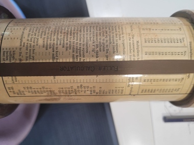
Instrument - Fuller Spiral Cylindrical Slide Rule, W.F. Stanley & Co, 1935
... The spiral logarithmic scale greatly increases the precision and computing power of the slide rule. ...The Fuller cylindrical slide rule, is a cylindrical slide rule with a helical main scale taking 50 turns around the cylinder. This creates an instrument of considerable precision – it is equivalent to a traditional slide rule 25.40 metres (1,000 inches) long. It was invented in 1878 by George Fuller, professor of engineering at Queen's University Belfast, and despite its size and price it remained on the market for nearly a century because it outperformed nearly all other slide rules. He patented it in Britain in 1878, described it in a journal in 1879 and in that year he also patented it the United States, depositing a patent model. As with other slide rules, the Fuller is limited to calculations based on multiplication and division with additional scales allowing for trigonometrical and exponential functions. The mechanical calculators produced in the same era were generally restricted to addition and subtraction with only advanced versions, like the Arithmometer, able to multiply and divide. Even these advanced machines could not perform trigonometry or exponentiation and they were bigger, heavier and much more expensive than the Fuller. In the mid-twentieth century the handheld Curta mechanical calculator became available which also competed in convenience and price. However, for scientific calculations the Fuller remained viable until 1973 when it was made obsolete by the HP-35 handheld scientific electronic calculator. Fuller's calculators were manufactured by the scientific instrument maker W.F. Stanley & Co. of London who made nearly 14,000 between 1878 and 1973.Like all slide rules, logarithmic scales are used to facilitate calculations more quickly and efficiently. The spiral logarithmic scale greatly increases the precision and computing power of the slide rule. In addition, its tables provide useful information to its users, most likely engineers. Its remarkable length permitted a high level of precision in calculations; calculations could be made to 4 or 5 significant digitsThe fuller calculator, is a cylindrical slide rule with a helical main scale taking 50 turns around the cylinder. There is a papier-mache cylinder fastened to a mahogany handle. A second papier-mache cylinder is a slide fit over the first. Both cylinders are covered in paper varnished with shellac. A brass pointer with an engraved index marker at its tip is attached to the handle and a second brass pointer is attached to the top cap. On the outer cylinder is a helical logarithmic scale 500" (41'8" or about 12.5 m) in length. This cylinder can be slid and rotated upon the inner one and hence with the correct sequence of movements, multiplications and divisions can be made and the answers read off the two pointers which project over the cylindrical scale.FULLER CALCULATOR inscribed on brass pointerscientific instrument, mathematics, calculating