Showing 146 items matching "cook islands"
-
 Flagstaff Hill Maritime Museum and Village
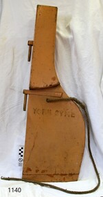
Functional object - Rudder, Adelaide Ship Construction International, ca 1961
... ...Cook Islands...It is sailing under the flag of the Cook Islands. Its gross tonnage is 149 tons. ...It is sailing under the flag of the Cook Islands. Its gross tonnage is 149 tons. ...Rudder from the tug boat YORK SYME, built in 1961 by ADELAIDE SHIP CONSTRUCTION INTERNATIONAL - PORT ADELAIDE, AUSTRALIA. It is sailing under the flag of the Cook Islands. Its gross tonnage is 149 tons. The rudder is believed to come from a lifeboat previously attached to the Tug. The tug York Syme operated in various ports in New Zealand until around 2011. It is believed this is when it went to the Cook Islands. The registered owner is unknown at this time.The rudder is from the 1961 Tug York Syme. Its size suggests it was from the tug's lifeboat or ancillary boat. It is an example of marine technology from the mid-20th century. Although small, it works on similar principles to 19th-century rudders from the large sailing ships. A comparison of size and construction can be made between the various rudders from different eras in our collection.Rudder; small blonde wooden rudder from a small boat. It has two brass fittings. A thin spliced rope has been passed through a hole near the rudder's neck. A stamped inscription is located just below the rope.Stamped in black; "YORK SYME"warrnambool, shipwreck coast, flagstaff hill, flagstaff hill maritime museum, flagstaff hill maritime village, marine equipment, steering, navigation, rudder, adelaide ship construction international, tug boat, york syme, cook islands, marine technology, ship fitting -
 Phillip Island and District Historical Society Inc.
Book, GILL, William Wyatt, Myths and songs from the South Pacific / by Rev. William Wyatt Gill ; With a preface by F. Max Mu?ller, 1876
... ...cook islands...Phillip Island and District Historical Society Inc. phillip-island-and-the-bass-coast Mythology polynesian mangaia cook islands religion songs polynesia Labelled 'Cowes Municipal Public Library', 'Phillip Island Historical Society, Cleeland Bequest'. ...Labelled 'Cowes Municipal Public Library', 'Phillip Island Historical Society, Cleeland Bequest'.mythology, polynesian, mangaia, cook islands, religion, songs, polynesia -
Clunes Museum
Coin - COINS, 2004
... .1 Cook Island 50 cent coin (currently unavailable 19/8/2019) .2 Ned Kelly collector coin, mounted on card...All in plastic sleeve .1 Cook Island 50 cent coin (currently unavailable 19/8/2019) .2 Ned Kelly collector coin, mounted on card Coin COINS Perth Mint ....1 Cook Island 50 cent coin (currently unavailable 19/8/2019) .2 Ned Kelly collector coin, mounted on card.2 Coin has Kelly bust and picture in armour on front, Queens head on back. Card has picture of helmet on front and Ned Kelly history on back. All in plastic sleevened kelly, 50cents coin, collector coin, commemorative coin -
 Mission to Seafarers Victoria
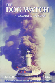
Journal (item) - Periodicals-Annual, Shiplovers' Society of Victoria, The Annual Dog Watch
... J Abernethy - 33 Crewing in Endeavour - Phoenix Arrien - 34 Finished With Engines - Ian L Barton - 45 Lighterage on Norfolk Island - Harrow Morgan - 53 Ship-owners Liability - ‘Flinders Bar’- 59 Nelson -Dr J H Leavesley - 61 The Knife Sheath - W P Shemmeld - 66 A Surfeit of Adventure - Stan Evans - 70 Cook’s Island - Jeremy Gadd - 75 Pig Overboard - Alf (Bluey) Thornton - 80 Educated - Noel Smith - 83 Jack Of All Trades - ‘Flinders Bar’ - 90 Tacking Ship Off Shore - Walter Frederick Stevens - 93 Australia’sMost Inland Shipwreck - Roy Stuart - 95 The Barwon Beer Crisis - R N Theile - 97 New Year Fireworks - Kenneth Shewan - 102 The Philadelphia Story - John Thompson - 104 AB Nuisance — Conclusion - Mick Hardware - 107 SSV Officers & TDW Editors - Kenneth Shewan - 108 Book Reviews - - 111...J Abernethy - 33 Crewing in Endeavour - Phoenix Arrien - 34 Finished With Engines - Ian L Barton - 45 Lighterage on Norfolk Island - Harrow Morgan - 53 Ship-owners Liability - ‘Flinders Bar’- 59 Nelson -Dr J H Leavesley - 61 The Knife Sheath - W P Shemmeld - 66 A Surfeit of Adventure - Stan Evans - 70 Cook’s Island - Jeremy Gadd - 75 Pig Overboard - Alf (Bluey) Thornton - 80 Educated - Noel Smith - 83 Jack Of All Trades - ‘Flinders Bar’ - 90 Tacking Ship Off Shore - Walter Frederick Stevens - 93 Australia’sMost Inland Shipwreck - Roy Stuart - 95 The Barwon Beer Crisis - R N Theile - 97 New Year Fireworks - Kenneth Shewan - 102 The Philadelphia Story - John Thompson - 104 AB Nuisance — Conclusion - Mick Hardware - 107 SSV Officers & TDW Editors - Kenneth Shewan - 108 Book Reviews - - 111 The Annual Dog Watch Journal Periodicals-Annual Shiplovers' Society of Victoria ...This journal provides the reader with glimpses of the adventures and hardships of a seaman's life. Many of the stories are of sailing ships.Contributes to our knowledge of the importance of shipping and places on record those stories of the sea which would otherwise be lost.Contents Editorial - Harrow Morgan - 5 Sentinel’s of Gellibrand’s Point - Cliff Gibson - 6 Australia Day - C H Longstaff - 15 Capt. Joseph Ferrell Colton - Kenneth Shewan - 16 James Craig — A unique ship for the Southern Hemisphere - Hugh Lander - 20 The Wreck of the Isis - Margaret Grice - 29 Unusual Maritime Hazards - Capt. J Abernethy - 33 Crewing in Endeavour - Phoenix Arrien - 34 Finished With Engines - Ian L Barton - 45 Lighterage on Norfolk Island - Harrow Morgan - 53 Ship-owners Liability - ‘Flinders Bar’- 59 Nelson -Dr J H Leavesley - 61 The Knife Sheath - W P Shemmeld - 66 A Surfeit of Adventure - Stan Evans - 70 Cook’s Island - Jeremy Gadd - 75 Pig Overboard - Alf (Bluey) Thornton - 80 Educated - Noel Smith - 83 Jack Of All Trades - ‘Flinders Bar’ - 90 Tacking Ship Off Shore - Walter Frederick Stevens - 93 Australia’sMost Inland Shipwreck - Roy Stuart - 95 The Barwon Beer Crisis - R N Theile - 97 New Year Fireworks - Kenneth Shewan - 102 The Philadelphia Story - John Thompson - 104 AB Nuisance — Conclusion - Mick Hardware - 107 SSV Officers & TDW Editors - Kenneth Shewan - 108 Book Reviews - - 111sailing ships, steamships, shipping, seafaring life, shiplovers' society of victoria, dog watch -
 Bendigo Military Museum
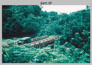
Photograph - Royal Australian Survey Corps Surveyors in the Field – Project Cutlass, New Guinea, 1956 – 1957
... Kev Parker (cook) New Ireland. .11) - Photo, colour, 1957. Brian Berkery taking a break, Top Manor Island, Lihir Island Group off New Ireland. ...Kev Parker (cook) New Ireland. .11) - Photo, colour, 1957. Brian Berkery taking a break, Top Manor Island, Lihir Island Group off New Ireland. ...This is a set of 23 photographs of surveyors and support staff in the field undertaking tasks in New Guinea 1956 – 1957. The surveyors were employed in the establishment of mapping and geodetic control for Project Cutlass, the “Ship-Shore” survey of the New Ireland province. In this survey operation surveyors used theodolites to observe horizontal and vertical angles and chains to measure base line distances between survey stations. Bob Skitch shown in photo .7P was in the 2nd year of his career in the Australian Army. He achieved the rank of Lieutenant-Colonel, and his last appointment was the CO of the Army Survey Regiment from 1976 to 1980.This is a set of 23 photographs of surveyors and support staff in the field undertaking duties during Project Cutlass located in New Ireland, New Guinea 1956 – 1957. The photographs were printed on photographic paper and are part of the Army Survey Regiment’s Collection. The photographs were scanned at 300 dpi. .1) - Photo, colour, 1956. Surveyors travelling main road from Kavieng to Namatanai, New Ireland. .2) - Photo, colour, 1956. Unidentified surveyors assessing recovery of their vehicle after bridge collapsed on west side of New Ireland. .3) - Photo, colour, 1956. Unidentified surveyors assessing recovery of their vehicle after bridge collapsed over flooded creek on west side of New Ireland. .4) - Photo, colour, 1956. Survey personnel L to R: Bev Uwins, John Lambie, Bob Thompson, New Ireland. .5) - Photo, colour, 1956. Survey base camp, New Ireland. .6) - Photo, black & white, 1956-1957. Geoff Helsham with possible human remains, New Ireland. .7) - Photo, black & white, 1956-1957. Bob Skitch undertaking survey observations using Wild T2 theodolite, New Ireland. .8) - Photo, black & white, 1956-1957. Chas Beach undertaking survey observations using Wild T2 theodolite, New Ireland. .9) & .10) - Photo, black & white, 1956-1957. Kev Parker (cook) New Ireland. .11) - Photo, colour, 1957. Brian Berkery taking a break, Top Manor Island, Lihir Island Group off New Ireland. Latitude -2° 46”, Longitude 152° 40”. .12) - Photo, colour, 1957. Survey base camp L to R: Chas Beach, Bev Uwins, Feni Islands, New Ireland. Latitude -4° 05”, Longitude 153° 45”. .13) - Photo, colour, 1957. A Hous Kiap. (Kiaps, known formally as district officers and patrol officers, were travelling representatives of the British and Australian governments), New Ireland. .14) & .15) - Photo, colour, 1957. L to R: Joe Farrington, Tom Royle Bob undertaking survey observations using theodolites from an improvised timber tower, New Ireland. .16) & .17) - Photo, colour, 1957. US Army ship FS216 used for ship-to-shore triangulation docked at Rabaul, New Britain. .18) - Photo, colour, 1957. US Army ship FS216 used for ship-to-shore triangulation docked at Kavieng, New Ireland. Sight target on top of mast. .19) - Photo, colour, 1957. Survey personnel onboard US Army ship FS392, L to R: Peter Frodsham, Bob Thompson, Doc Reid, John Underwood, remainder unidentified, New Ireland. .20) - Photo, colour, 1957. Survey base line party heading ashore, New Ireland. .21) - Photo, colour, 1957. Survey personnel rowing US Army assault boat L to R: Kev Parker, Chas Beach, folded up survey beacons overhanging stern, New Ireland. .22) - Photo, colour, 1957. Les Bailey onboard US Army ship departing Rabaul, New Britain for Brisbane. .23) - Photo, colour, 1957. Ron Newman onboard US Army ship departing Rabaul, New Britain for Brisbane. Active volcano in background..1P to .23P annotated on back – ‘Operation Cutlass’, personnel names, the year and the location. royal australian survey corps, rasvy, army survey regiment, fortuna, a, army svy regt, asr, surveying -
 Bendigo Military Museum
Photograph - RA Svy Project C4 Aerodist Operation, Eastern & Western Arnhem Land, NT, 1967, 1968
... They are part of the Army Survey Regiment’s Collection. .1) to .2) – Photo, black & white, 1968, unidentified soldier with an opened can of food, possibly bully beef. .3) – Photo, black & white, 15 Aug 1968, aerial view of terrain taken from a helicopter in vicinity of MILINGIMBI SIERRA. .4) – Photo, black & white, 1967, aerial view of an island taken from a helicopter. .5) & .6) – Photo, black & white, 1967, unidentified soldier driving a Haflinger 4x4 Light utility vehicle with trailer. .7) – Photo, black & white, 1967, unidentified surveyors taking vertical measurements with a leveling instrument and staff. .8) – Photo, black & white, 1967, Australian Army Sioux Light Observation Helicopter (LOH) with float removed. .9) to .11) – Photo, black & white, 1967, Australian Army Sioux Light Observation Helicopter (LOH) with floats. .12) – Photo, black & white, 1967, civilian Bell 47G-2 helicopter (Australian Army Sioux LOH equivalent) refuelled. .13) – Photo, black & white, 1967, survey station on coastline surrounded by white plastic aerial photographic identification panels lined with rocks. .14) & .15) – Photo, black & white, 1967, soldier (possibly a signaller from RA Sigs) operating a radio. .16) – Photo, black & white, 1967, Central Comd Fd Svy Unit Operations Section tent, Main Base Gove (Nhulunbuy) L to R: SPR Harry Dunn, WO1 Pat Wood BEM. .17) – Photo, black & white, 1967, Central Comd Fd Svy Unit Operations Section tent, Main Base Gove (Nhulunbuy) L to R: unidentified, WO1 Pat Wood BEM. .18) – Photo, black & white, 1967, Central Comd Fd Svy Unit Operations Section, Main Base Gove (Nhulunbuy), unidentified Australian Army Catering Corps cook preparing meals. .19) – Photo, black & white, 1967, Central Comd Fd Svy Unit Operations Section, Main Base Gove (Nhulunbuy) mess tent in readiness for meals. .20) – Photo, black & white, 1967, Bank of batteries in transit boxes undergoing recharging using generators. .21) – Photo, black & white, 1967, A topographic survey identification plaque set in a concrete block being weighed using a set of scales hanging from slaughtering gallows. .22) – Photo, black & white, 1967, CPL (Geoff or Gary) Larkin operating the remote Aerodist MRC2 ground instrument at Veronica Island, located north of Nhulunbuy. .23) – Photo, black & white, 1967, L to R: CPL (Geoff or Gary) Larkin with unidentified surveyor operate the remote Aerodist MRC2 ground instrument at Venica Island, located north of Nhulunbuy. .24) & .25 – Photo, black & white, 1967, The Aerodist MRC2 Remote antenna. .26) – Photo, black & white, 1967, The Aerodist MRC2 Remote antenna....They are part of the Army Survey Regiment’s Collection. .1) to .2) – Photo, black & white, 1968, unidentified soldier with an opened can of food, possibly bully beef. .3) – Photo, black & white, 15 Aug 1968, aerial view of terrain taken from a helicopter in vicinity of MILINGIMBI SIERRA. .4) – Photo, black & white, 1967, aerial view of an island taken from a helicopter. .5) & .6) – Photo, black & white, 1967, unidentified soldier driving a Haflinger 4x4 Light utility vehicle with trailer. .7) – Photo, black & white, 1967, unidentified surveyors taking vertical measurements with a leveling instrument and staff. .8) – Photo, black & white, 1967, Australian Army Sioux Light Observation Helicopter (LOH) with float removed. .9) to .11) – Photo, black & white, 1967, Australian Army Sioux Light Observation Helicopter (LOH) with floats. .12) – Photo, black & white, 1967, civilian Bell 47G-2 helicopter (Australian Army Sioux LOH equivalent) refuelled. .13) – Photo, black & white, 1967, survey station on coastline surrounded by white plastic aerial photographic identification panels lined with rocks. .14) & .15) – Photo, black & white, 1967, soldier (possibly a signaller from RA Sigs) operating a radio. .16) – Photo, black & white, 1967, Central Comd Fd Svy Unit Operations Section tent, Main Base Gove (Nhulunbuy) L to R: SPR Harry Dunn, WO1 Pat Wood BEM. .17) – Photo, black & white, 1967, Central Comd Fd Svy Unit Operations Section tent, Main Base Gove (Nhulunbuy) L to R: unidentified, WO1 Pat Wood BEM. .18) – Photo, black & white, 1967, Central Comd Fd Svy Unit Operations Section, Main Base Gove (Nhulunbuy), unidentified Australian Army Catering Corps cook preparing meals. .19) – Photo, black & white, 1967, Central Comd Fd Svy Unit Operations Section, Main Base Gove (Nhulunbuy) mess tent in readiness for meals. .20) – Photo, black & white, 1967, Bank of batteries in transit boxes undergoing recharging using generators. .21) – Photo, black & white, 1967, A topographic survey identification plaque set in a concrete block being weighed using a set of scales hanging from slaughtering gallows. .22) – Photo, black & white, 1967, CPL (Geoff or Gary) Larkin operating the remote Aerodist MRC2 ground instrument at Veronica Island, located north of Nhulunbuy. .23) – Photo, black & white, 1967, L to R: CPL (Geoff or Gary) Larkin with unidentified surveyor operate the remote Aerodist MRC2 ground instrument at Venica Island, located north of Nhulunbuy. .24) & .25 – Photo, black & white, 1967, The Aerodist MRC2 Remote antenna. .26) – Photo, black & white, 1967, The Aerodist MRC2 Remote antenna. ...This is a set of 26 photographs of Royal Australian Survey Corps (RA Svy) personnel from Central Comd Fd Svy Unit (Adelaide) on Aerodist survey operation - Project C4 in Eastern Arnhem Land, Northern Territory in 1967 (photos .4P to .26P) and in Western Arnhem Land, Northern Territory in 1968 (photos .1P to .3P). Photos of personnel were taken either at the operations base at Numbulwar or the main base at Gove (Nhulunbuy). RA Svy conducted nineteen Aerodist operations for 12 years from 1964 to 1975. Aerodist MRC2 was a tellurometer-based system adapted for aircraft to accurately measure distances between non-intervisible ground survey stations, using the aircraft as an intermediate station. Lower order geodetic results could be achieved by survey network trilateration. The measured distances between stations formed survey networks from which each station’s latitude and longitude was computed. Aerodist MRC2 was RA Svy’s major horizontal control survey tool for mainly medium scale topographic mapping (scale 1:100,000 Class A being spatially accurate to within 50 metres) in PNG, northern NT, north-west WA, Kalimantan Barat (West) Indonesia, Sumatra Indonesia, Gulf of Carpentaria and Cape York, QLD. In 1967, the Aerodist MRC2 Master equipment was installed in the aircraft featured in this set of photos, Executive Air Services’ (Essendon VIC) Grand Aero Commander VH-EXX. It was the same aircraft type and company contracted to Division of National Mapping for Aerodist MRC2 surveys. From July to October 1967 the aircraft was attached to Central Comd Fd Svy Unit (Adelaide - Major Don Ridge) on Project C4 eastern-Arnhem Land NT, where 317 Aerodist lines measuring 17,300 line miles were successfully completed. This was the most productive Aerodist project thus far. The most common helicopter used by RA Svy up to 1972 was the civilian Bell 47G-2 and the Sioux Light Observation Helicopters (LOH), the Australian Army’s equivalent featured in this photo set. These light observation helicopters had a limiting load carrying capacity of up to about 500 pounds. By comparison, one Aerodist team including two people weighed up to 1,500 pounds. In 1968, after completion of the Kimberley Aerodist Operation project, the Aerodist system in VH-EXX was immediately deployed to western-Arnhem Land NT for Central Comd Fd Svy Unit (Adelaide - Major Don Ridge) to complete the mapping control across northern NT from mid-July to October. The Aerodist MRC2 Remote antenna seen in Photos .24P to .26P is mounted on a 20 foot pole tower. The antenna direction was controlled by wires/ropes to the two arms under the dish at right angles. The antenna elevation could be changed to the vertical for aircraft height checks as seen in photo .25P. Source: Royal Australian Survey Corps – Aerodist Years 1964-1975 by Peter Jensen. Refer to Item 6449.30P for more photos taken during these Aerodist survey operations.This is a set of 26 photographs of Royal Australian Survey Corps (RA Svy) personnel on Aerodist survey operations in Eastern Arnhem Land, Northern Territory in 1967 and Western Arnhem Land, Northern Territory in 1968. The photographs are on 35mm negative film and scanned at 96 dpi. They are part of the Army Survey Regiment’s Collection. .1) to .2) – Photo, black & white, 1968, unidentified soldier with an opened can of food, possibly bully beef. .3) – Photo, black & white, 15 Aug 1968, aerial view of terrain taken from a helicopter in vicinity of MILINGIMBI SIERRA. .4) – Photo, black & white, 1967, aerial view of an island taken from a helicopter. .5) & .6) – Photo, black & white, 1967, unidentified soldier driving a Haflinger 4x4 Light utility vehicle with trailer. .7) – Photo, black & white, 1967, unidentified surveyors taking vertical measurements with a leveling instrument and staff. .8) – Photo, black & white, 1967, Australian Army Sioux Light Observation Helicopter (LOH) with float removed. .9) to .11) – Photo, black & white, 1967, Australian Army Sioux Light Observation Helicopter (LOH) with floats. .12) – Photo, black & white, 1967, civilian Bell 47G-2 helicopter (Australian Army Sioux LOH equivalent) refuelled. .13) – Photo, black & white, 1967, survey station on coastline surrounded by white plastic aerial photographic identification panels lined with rocks. .14) & .15) – Photo, black & white, 1967, soldier (possibly a signaller from RA Sigs) operating a radio. .16) – Photo, black & white, 1967, Central Comd Fd Svy Unit Operations Section tent, Main Base Gove (Nhulunbuy) L to R: SPR Harry Dunn, WO1 Pat Wood BEM. .17) – Photo, black & white, 1967, Central Comd Fd Svy Unit Operations Section tent, Main Base Gove (Nhulunbuy) L to R: unidentified, WO1 Pat Wood BEM. .18) – Photo, black & white, 1967, Central Comd Fd Svy Unit Operations Section, Main Base Gove (Nhulunbuy), unidentified Australian Army Catering Corps cook preparing meals. .19) – Photo, black & white, 1967, Central Comd Fd Svy Unit Operations Section, Main Base Gove (Nhulunbuy) mess tent in readiness for meals. .20) – Photo, black & white, 1967, Bank of batteries in transit boxes undergoing recharging using generators. .21) – Photo, black & white, 1967, A topographic survey identification plaque set in a concrete block being weighed using a set of scales hanging from slaughtering gallows. .22) – Photo, black & white, 1967, CPL (Geoff or Gary) Larkin operating the remote Aerodist MRC2 ground instrument at Veronica Island, located north of Nhulunbuy. .23) – Photo, black & white, 1967, L to R: CPL (Geoff or Gary) Larkin with unidentified surveyor operate the remote Aerodist MRC2 ground instrument at Venica Island, located north of Nhulunbuy. .24) & .25 – Photo, black & white, 1967, The Aerodist MRC2 Remote antenna. .26) – Photo, black & white, 1967, The Aerodist MRC2 Remote antenna.The following photos are annotated in black ink on edge of film negative: .3P – ’15 Aug ’68, 2000’, 1-C18 ’68 MILINGIMBI SIERRA’ .4P – ’U462’ .8P – ‘1-C3/67 Float Removed’ .13P – ‘U477 10-C3/67 .20P - ‘2-C3/67 Bank of Chargers’ .21P - ‘3-C3/67 Gallows & Scales’ .22P - ‘0462 VERONICA ISLAND NT, CPL Larkin’ .23P - ‘0462 VERONICA ISLAND NT’ .24P - ‘4-C3/67 20’ Aerodist Tower’ .25P - ‘5-C3/67 20’ Aerodist Tower’ .26P - ‘6-C3/67 20’ Aerodist Tower’royal australian survey corps, rasvy, army survey regiment, army svy regt, fortuna, asr, aerodist, surveying, central comd fd svy unit -
 Phillip Island and District Historical Society Inc.
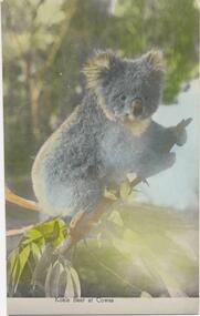
Photograph, Koala, 1950's
... island...molly cook...Phillip Island and District Historical Society Inc. phillip-island-and-the-bass-coast Donated by Molly Cook koalas wildlife - koala cowes phillip island molly cook "Koala Bear at Cowes" Colour photograph of a Koala on a branch of a tree. ...Donated by Molly CookColour photograph of a Koala on a branch of a tree."Koala Bear at Cowes"koalas, wildlife - koala, cowes, phillip island, molly cook -
 Phillip Island and District Historical Society Inc.
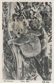
Photograph - Post Card, Koala, 1950
... island...molly cook...Phillip Island and District Historical Society Inc. phillip-island-and-the-bass-coast Donated by Molly Cook wildlife - koala koalas cowes phillip island molly cook "Photo Shop Series" "Koala Bear" "Phillip Island" Black & White Postcard of a Koala and baby on it's back in a tree. ...Donated by Molly CookBlack & White Postcard of a Koala and baby on it's back in a tree."Photo Shop Series" "Koala Bear" "Phillip Island"wildlife - koala, koalas, cowes phillip island, molly cook -
 Phillip Island and District Historical Society Inc.
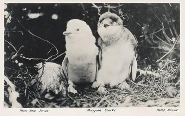
Photograph - Post Card, Penguin Chicks, 1950's
... Phillip Island and District Historical Society Inc. phillip-island-and-the-bass-coast Donated by Molly Cook wildlife - penguins penguins phillip island "Photo Shop Series" "Penguin Chicks" "Phillip Island" Black & White Postcart of two Penguin Chicks in foliage. ...Donated by Molly CookBlack & White Postcart of two Penguin Chicks in foliage."Photo Shop Series" "Penguin Chicks" "Phillip Island"wildlife - penguins, penguins, phillip island -
 Phillip Island and District Historical Society Inc.
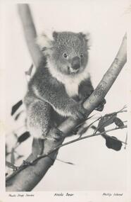
Photograph - Post Card, Koala, 1950's
... island...molly cook...Phillip Island and District Historical Society Inc. phillip-island-and-the-bass-coast Donated by Molly Cook wildlife - koala koala phillip island molly cook "Photo Shop Series" "Koala Bear" "Phillip Island" Black & White Postcard of a Koala sitting on a tree branch. ...Donated by Molly CookBlack & White Postcard of a Koala sitting on a tree branch."Photo Shop Series" "Koala Bear" "Phillip Island"wildlife - koala, koala, phillip island, molly cook -
 Phillip Island and District Historical Society Inc.
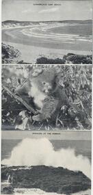
Postcard Folder, The Isle of Enchantment, 1946
... island...penguins...seals...the nobbies...seal rocks...the jetty shed cowes...summerland surf beach...newhaven to san remo bridge...dr cook...Fold out series of 8 photographs relating to Phillip Island. Donated by Dr Cook....Phillip Island and District Historical Society Inc. phillip-island-and-the-bass-coast Fold out series of 8 photographs relating to Phillip Island. Donated by Dr Cook. phillip island penguins seals the nobbies seal rocks the jetty shed cowes summerland surf beach newhaven to san remo bridge dr cook Front Cover: "Camera Highlights illustrating Cowes Phillip Island, Vic. ...Fold out series of 8 photographs relating to Phillip Island. Donated by Dr Cook.Black & White Folder of photographs: 1: Summerland Surf Beach 2: Koala 3: Breakers At The Nobbies 4: The Jetty at Cowes 5: Seals on Seal Rocks 6: Newhaven - San Remo Bridge 7: Penguins at Summerland Cowes 8: The Nobbies and Seal RocksFront Cover: "Camera Highlights illustrating Cowes Phillip Island, Vic. The Isle of Enchantment" Photos by A. J. Murray - Copyright. Each photo inscription as above in Physical Description. Back Cover: "Postage Rates within the British Empire - Without correspondence, in an unsealed envelope, will be 1.1/2d. If correspondence is added, postage will be 2.1/2d. whether envelope is ealsed or unsealed. Foreign rate, 3.1/2d. To..................................... From..............................."phillip island, penguins, seals, the nobbies, seal rocks, the jetty shed cowes, summerland surf beach, newhaven to san remo bridge, dr cook -
 Phillip Island and District Historical Society Inc.
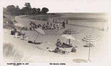
Photograph - Post Card, 1933 - 38
... island...cowes beach...dr cook...Phillip Island and District Historical Society Inc. phillip-island-and-the-bass-coast One of two photograps donated by Dr Cook phillip island cowes beach dr cook "The Beach, Cowes". ...One of two photograps donated by Dr CookBlack & White photograph of people on Cowes beach with four beach umbrellas in the foreground. Trees and grass to the left of photograph."The Beach, Cowes". Valentine, Series No. 2267 Copywrightphillip island, cowes beach, dr cook -
 Phillip Island and District Historical Society Inc.
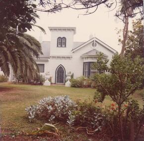
Photograph, 1978/9
... Island. He maintained the Beacon Light on Woolamai Point close to his house. Owned and occupied by family since 1869. local history photographs buildings - historical coloured photograph john cook woolamai house cleeland family history Photograph coloured. ...Woolamai House was built in approx 1869 on part of Capt Cleeland's property which covered most of the eastern end of Phillip Island. He maintained the Beacon Light on Woolamai Point close to his house. Owned and occupied by family since 1869.Photograph coloured. Front aspect of house showing front door and bay window on right. Timber turret above - garden in front. Construction built for Capt. John Cleeland approx 1869. Known as Woolamai House.local history, photographs, buildings - historical, coloured photograph, john cook, woolamai house, cleeland family history -
 Phillip Island and District Historical Society Inc.
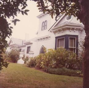
Photograph, 1978/9
... Island. He maintained the Beacon Light on Woolamai Point close to his house. Owned and occupied by family since 1869. local history photographs buildings - historical coloured photograph john cook woolamai house cleeland family history Coloured photograph - front aspect of timber house taken from the side angle showing bay window, front door, turret and rooms beyond. ...Woolamai House was built in approx 1869 on part of Capt Cleeland's property which covered most of the eastern end of Phillip Island. He maintained the Beacon Light on Woolamai Point close to his house. Owned and occupied by family since 1869.Coloured photograph - front aspect of timber house taken from the side angle showing bay window, front door, turret and rooms beyond. Lawn in front. Built for Capt. John Cleeland approx 1869.local history, photographs, buildings - historical, coloured photograph, john cook, woolamai house, cleeland family history -
 Phillip Island and District Historical Society Inc.
Photograph, 1978/9
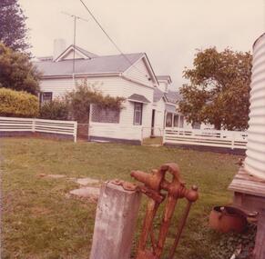
... Island. He maintained the Beacon Light on Woolamai Point close to his house. Owned and occupied by family since 1869. local history photographs buildings - historical woolamai house coloured photograph john cook cleeland family history Coloured photograph - back view of the timber house, painted white with grey roof. ...Woolamai House was built in approx 1869 on part of Capt Cleeland's property which covered most of the eastern end of Phillip Island. He maintained the Beacon Light on Woolamai Point close to his house. Owned and occupied by family since 1869.Coloured photograph - back view of the timber house, painted white with grey roof. Two turret rooms. White painted fence. Lawn in foreground. ?Fernery on right.local history, photographs, buildings - historical, woolamai house, coloured photograph, john cook, cleeland family history -
 Phillip Island and District Historical Society Inc.
Photograph, 1978/9
... Island. He maintained the Beacon Light on Woolamai Point close to his house. Owned and occupied by family since 1869. local history photographs buildings - historical coloured photograph john cook woolamai house cleeland family history Coloured photograph - back view of white timber house taken from left hand rear end showing white painted fence and the gates. ...Woolamai House was built in approx 1869 on part of Capt Cleeland's property which covered most of the eastern end of Phillip Island. He maintained the Beacon Light on Woolamai Point close to his house. Owned and occupied by family since 1869.Coloured photograph - back view of white timber house taken from left hand rear end showing white painted fence and the gates. Water tank shown in foreground.local history, photographs, buildings - historical, coloured photograph, john cook, woolamai house, cleeland family history -
 Phillip Island and District Historical Society Inc.
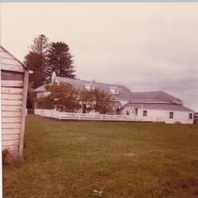
Photograph, 1978/9
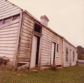
... Island. He maintained the Beacon Light on Woolamai Point close to his house. Owned and occupied by family since 1869. local history photographs buildings - historical coloured photograph john cook woolamai house cleeland family history Coloured photograph - view of wooden outbuilding, showing two doors and two windows - chimney. ...Woolamai House was built in approx 1869 on part of Capt Cleeland's property which covered most of the eastern end of Phillip Island. He maintained the Beacon Light on Woolamai Point close to his house. Owned and occupied by family since 1869.Coloured photograph - view of wooden outbuilding, showing two doors and two windows - chimney.local history, photographs, buildings - historical, coloured photograph, john cook, woolamai house, cleeland family history -
 Phillip Island and District Historical Society Inc.
Photograph, 1978/9
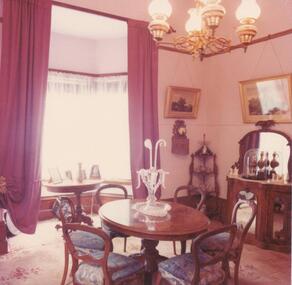
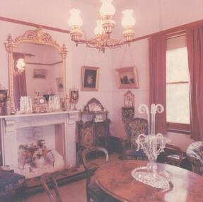
... Island. He maintained the Beacon Light on Woolamai Point close to his house. Owned and occupied by family since 1869. local history photographs buildings - historical coloured photograph john cook woolamai house cleeland family history Coloured photograph. ...Woolamai House was built in approx 1869 on part of Capt Cleeland's property which covered most of the eastern end of Phillip Island. He maintained the Beacon Light on Woolamai Point close to his house. Owned and occupied by family since 1869.Coloured photograph. The parlor in Woolamai House. Round table with glass centrepiece. 6 Victorian Balloon chairs. Sideboard and Whatnot.local history, photographs, buildings - historical, coloured photograph, john cook, woolamai house, cleeland family history -
 Phillip Island and District Historical Society Inc.
Photograph, 1978/9
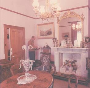
... Island. He maintained the Beacon Light on Woolamai Point close to his house. Owned and occupied by family since 1869. local history photographs buildings - historical coloured photograph john cook woolamai house cleeland family history Coloured photograph showing the parlor in Woolamai House with round table and 6 Victorian Balloon chairs - lounge in background. ...Woolamai House was built in approx 1869 on part of Capt Cleeland's property which covered most of the eastern end of Phillip Island. He maintained the Beacon Light on Woolamai Point close to his house. Owned and occupied by family since 1869.Coloured photograph showing the parlor in Woolamai House with round table and 6 Victorian Balloon chairs - lounge in background.local history, photographs, buildings - historical, coloured photograph, john cook, woolamai house, cleeland family history -
 Phillip Island and District Historical Society Inc.
Photograph, 1978/9
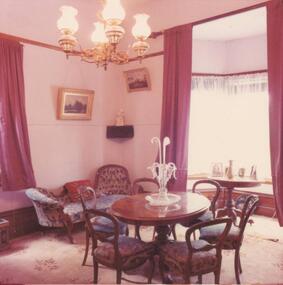
... Island. He maintained the Beacon Light on Woolamai Point close to his house. Owned and occupied by family since 1869. local history photographs buildings - historical coloured photograph john cook woolamai house cleeland family history Coloured photograph showing the Parlor in Woolamai House - mirror above marble mantle piece. ...Woolamai House was built in approx 1869 on part of Capt Cleeland's property which covered most of the eastern end of Phillip Island. He maintained the Beacon Light on Woolamai Point close to his house. Owned and occupied by family since 1869.Coloured photograph showing the Parlor in Woolamai House - mirror above marble mantle piece. Table, chairs and whatnot.local history, photographs, buildings - historical, coloured photograph, john cook, woolamai house, cleeland family history -
 Phillip Island and District Historical Society Inc.
Photograph, 1978/9
... Island. He maintained the Beacon Light on Woolamai Point close to his house. Owned and occupied by family since 1869. local history photographs buildings - historical coloured photograph john cook woolamai house cleeland family history Coloured photograph showing the Parlor - mirror above marble mantle piece. ...Woolamai House was built in approx 1869 on part of Capt Cleeland's property which covered most of the eastern end of Phillip Island. He maintained the Beacon Light on Woolamai Point close to his house. Owned and occupied by family since 1869.Coloured photograph showing the Parlor - mirror above marble mantle piece. Table with centrepiece on it. Chairs - Whatnot in corner. Harry Cleeland standing nearby.local history, photographs, buildings - historical, coloured photograph, john cook, woolamai house, cleeland family history -
 Phillip Island and District Historical Society Inc.
Photograph, 1978/9
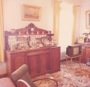
... Island. He maintained the Beacon Light on Woolamai Point close to his house. Owned and occupied by family since 1869. local history photographs buildings - historical coloured photograph john cook woolamai house cleeland family history Coloured photograph showing section of the Dining room - Sideboard in particular with the original silver and glassware brought out to Australia by Capt. ...Woolamai House was built in approx 1869 on part of Capt Cleeland's property which covered most of the eastern end of Phillip Island. He maintained the Beacon Light on Woolamai Point close to his house. Owned and occupied by family since 1869.Coloured photograph showing section of the Dining room - Sideboard in particular with the original silver and glassware brought out to Australia by Capt. Cleeland. Also Trophies and Ruby Glass drinking set from the London Exhibition. Television on small table.local history, photographs, buildings - historical, coloured photograph, john cook, woolamai house, cleeland family history -
 Phillip Island and District Historical Society Inc.
Photograph, 1978/9
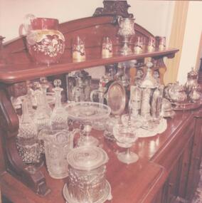
... Island. He maintained the Beacon Light on Woolamai Point close to his house. Owned and occupied by family since 1869. local history photographs buildings - historical coloured photograph john cook woolamai house cleeland family history Coloured photograph showing Sideboard with the original silver and glassware brought out to Australia by Capt. ...Woolamai House was built in approx 1869 on part of Capt Cleeland's property which covered most of the eastern end of Phillip Island. He maintained the Beacon Light on Woolamai Point close to his house. Owned and occupied by family since 1869.Coloured photograph showing Sideboard with the original silver and glassware brought out to Australia by Capt. John Cleeland. also Trophies and Ruby Glass drinking set from the London Exhibition. This is all displayed on the Sideboard.local history, photographs, buildings - historical, coloured photograph, john cook, woolamai house, cleeland family history -
 Phillip Island and District Historical Society Inc.
Photograph, Innishowen, 1978/9
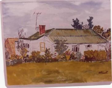
... cook...innishowen...ventnor...phillip island...island-and-the-bass-coast Innishowen - home of William Harbison from 1868. Bought by Gliddon Family in 1911 and demolished in 1976 by owner G Gliddon. Present photograph of painting taken 1978/1979 local history photographs buildings - historical coloured photograph john cook innishowen ventnor phillip island Harbison Innishowen - the home of William Harbison who owned most of the south western section of Phillip Island from 1868. ...Innishowen - home of William Harbison from 1868. Bought by Gliddon Family in 1911 and demolished in 1976 by owner G Gliddon. Present photograph of painting taken 1978/1979Innishowen - the home of William Harbison who owned most of the south western section of Phillip Island from 1868. Coloured photograph of painting of Innishowen showing house and garden. Green roofing iron.local history, photographs, buildings - historical, coloured photograph, john cook, innishowen, ventnor, phillip island, harbison -
 Phillip Island and District Historical Society Inc.
Photograph, 1978/9
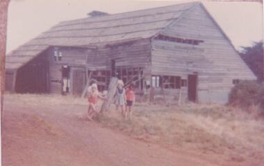
... cook...innishowen...ventnor...phillip island...island-and-the-bass-coast Supposed to have been built by J. D. McHaffie on his property at Ventnor and removed to Innishowen by Mr Harbison when he bought the property at Ventnor from J. D. McHaffie. In 1977 this shed was not on the property. local history photographs buildings - historical coloured photograph john cook innishowen ventnor phillip island Coloured photograph of wooden Shearing Shed. ...Supposed to have been built by J. D. McHaffie on his property at Ventnor and removed to Innishowen by Mr Harbison when he bought the property at Ventnor from J. D. McHaffie. In 1977 this shed was not on the property.Coloured photograph of wooden Shearing Shed. Roof of wooden shingles. Three children in foreground. The two girls are Graeme Gliddon's children. Boy unknown.local history, photographs, buildings - historical, coloured photograph, john cook, innishowen, ventnor, phillip island -
 Phillip Island and District Historical Society Inc.
Photograph, 1978/9
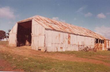
... cook...innishowen...ventnor...phillip island...island-and-the-bass-coast The big Hayshed was built by J. D. McHaffie on his property at Ventnor. He used timber washed up by the sea and roofing iron from the dome of the Exhibition Building in London. After purchasing the historic McHaffie homestead, Mr Harbison removed most of the buildings to Innishowen. It was still standing in 1977. local history photographs buildings - historical coloured photograph john cook ...The big Hayshed was built by J. D. McHaffie on his property at Ventnor. He used timber washed up by the sea and roofing iron from the dome of the Exhibition Building in London. After purchasing the historic McHaffie homestead, Mr Harbison removed most of the buildings to Innishowen. It was still standing in 1977."Innishowen". Coloured photograph of large galvanised iron haystack, rusted with age. Part of timber frame visible at right hand side. Training Jinker shown against the side of shed.local history, photographs, buildings - historical, coloured photograph, john cook, innishowen, ventnor, phillip island -
 Phillip Island and District Historical Society Inc.
Photograph, 1976
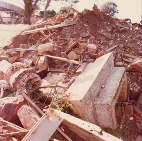
... cook...innishowen...ventnor...phillip island...Phillip Island and District Historical Society Inc. phillip-island-and-the-bass-coast As "Innishowen" was demolished in 1976 this photograph must have been taken around this time. The owner was G Gliddon whose family bought it in 1911. local history photographs buildings - historical coloured photograph john cook innishowen ventnor phillip island Coloured photograph of rubble from demolition of "Innishowen" house in 1976. ...As "Innishowen" was demolished in 1976 this photograph must have been taken around this time. The owner was G Gliddon whose family bought it in 1911.Coloured photograph of rubble from demolition of "Innishowen" house in 1976. Wood and concrete visible.local history, photographs, buildings - historical, coloured photograph, john cook, innishowen, ventnor, phillip island -
 Phillip Island and District Historical Society Inc.
Photograph, 1978/9
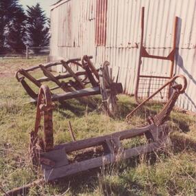
... cook...innishowen...ventnor...phillip island...Harbison, a bachelor, built "Innishowen" which means Island Home. local history photographs buildings - historical coloured photograph john cook innishowen ventnor phillip island Coloured photograph of Training Jinker standing beside large Hayshed at "Innishowen" Ventnor. ...The Training Jinker was used by Messrs. Cleeland and Harbison during the last century. Harbison, a bachelor, built "Innishowen" which means Island Home.Coloured photograph of Training Jinker standing beside large Hayshed at "Innishowen" Ventnor.local history, photographs, buildings - historical, coloured photograph, john cook, innishowen, ventnor, phillip island -
 Phillip Island and District Historical Society Inc.
Photograph, 1978/9
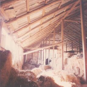
... cook...innishowen...ventnor...phillip island...island-and-the-bass-coast The hayshed at "Innishowen" was built by J. D. McHaffie on his property at Ventnor and moved to "Innishowen" by Mr. Harbison when he bought the McHaffie property. local history photographs buildings - historical rural industry coloured photograph john cook innishowen ventnor phillip island Coloured photograph of interior of hayshed showing many bales of hay and construction of roof. ...The hayshed at "Innishowen" was built by J. D. McHaffie on his property at Ventnor and moved to "Innishowen" by Mr. Harbison when he bought the McHaffie property.Coloured photograph of interior of hayshed showing many bales of hay and construction of roof.local history, photographs, buildings - historical, rural industry, coloured photograph, john cook, innishowen, ventnor, phillip island -
 Phillip Island and District Historical Society Inc.
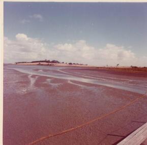
Photograph, 1978/9
... cook...churchill island...Named Churchill Island after John Churchill Esq. of Dawlish in the County of Devon. local history photographs buildings - historical rural industry coloured photograph john cook churchill island Coloured photograph of Churchill Island taken from Jetty on Phillip Island. ...On 28th March 1801, Lieut. James Grant sailed across from Rhyll, landed and inspected Churchill Island. His men cleared some ground and planted seeds including Victoria's first crop of wheat. Named Churchill Island after John Churchill Esq. of Dawlish in the County of Devon.Coloured photograph of Churchill Island taken from Jetty on Phillip Island. Low tide is evident.local history, photographs, buildings - historical, rural industry, coloured photograph, john cook, churchill island