Showing 12 items matching "county of ripon"
-
 Stawell Historical Society Inc
Map, County of Ripon, 1858
... County of Ripon...County of Ripon...Stawell Historical Society Inc 46 Longfield St Stawell grampians Stawell County of Ripon County of Ripon Map ...County of Riponstawell -
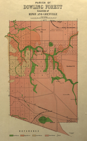 Federation University Historical Collection
Plan, Parish of Dowling Forest, County of Ripon and Grenville, 19
... Parish of Dowling Forest, County of Ripon and Grenville...Parish of Dowling Forest, County of Ripon and Grenville Plan Department of Crown Lands and Survey ...Scale [1:31 680]. 40 chains to 1 in.Geological map on a cadastral base, showing the occurence of reefs, and alluvial deposits. Relief shown by contours.dowling forest, wyndholm, wyndholm pre-emptive right, miners rest, ballarat racecourse, winter's swamp, police reserve, miner's rest, winters swamp, geology -
 Federation University Historical Collection
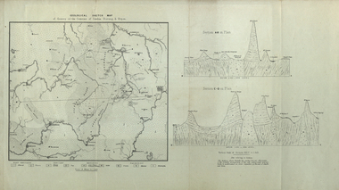
Map, Geological Sketch Map of of Dundas, Berung, and Ripon Counties
... ...county of berung...county of ripon...Map of the Counties of Dundas, Berung, and Ripon...county of dundas county of berung county of ripon map geology ararat stawell hamilton grampians Map of the Counties of Dundas, Berung, and Ripon Geological Sketch Map of of Dundas, Berung, and Ripon Counties Map Map ...Map of the Counties of Dundas, Berung, and Riponcounty of dundas, county of berung, county of ripon, map, geology, ararat, stawell, hamilton, grampians -
 Federation University Historical Collection
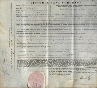
Document, Grant, by Purchase, Parish of Burrumbeet, Victoria, 1857, 1857
... ...county of ripon...This was ten acres, two roods and thirteen perches in the County of Ripon Parish of Burrumbeet. The land sold at Ballarat as Lot No 37. ...This was ten acres, two roods and thirteen perches in the County of Ripon Parish of Burrumbeet. The land sold at Ballarat as Lot No 37. ...John Ettershank of Ballarat purchased land for Ninety-three pounds, two shillings and four pence. This was ten acres, two roods and thirteen perches in the County of Ripon Parish of Burrumbeet. The land sold at Ballarat as Lot No 37. The document was witnessed by Sir Henry Barkly, Knight Commander of the Most Honorable Order of the Bath, Captain-General and Governor-in-Chief of the said Colony and Vice-Admiral, at Melbourne, VictoriaThick cream paper, badly stained. Hand written Official seal Dated 16 April 1857 Signed: Henry Barkly -Governor-in-Chief of the Colony Signed: William C Haines - Chief Secretary and Registrarjohn ettershank, ballarat, county of ripon, parish of burrumbeet, sir henry barkly, captain-general, governor-in-chief -
Stawell Historical Society Inc
Map, Bulgana, Counties of Borung & Ripon, 1959
... Bulgana, Counties of Borung & Ripon...Stawell Historical Society Inc 46 Longfield St Stawell grampians Stawell Bulgana, Counties of Borung & Ripon Bulgana, Counties of Borung & Ripon Map ...Bulgana, Counties of Borung & Riponstawell -
Stawell Historical Society Inc
Map, Physical description Concongella South, Counties of Borung & Ripon, 1957
... Concongella South, Counties of Borung & Ripon...Stawell Historical Society Inc 46 Longfield St Stawell grampians Stawell Concongella South, Counties of Borung & Ripon Physical description Concongella South, Counties of Borung & Ripon Map ...Concongella South, Counties of Borung & Riponstawell -
 Federation University Historical Collection
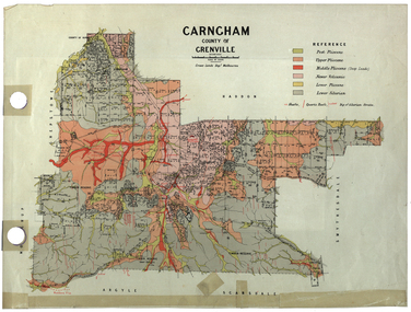
Plan, Carngham, County of Grenville
... ...county of ripon...snake valley timber reserve poverty point recreation reserve carngham county of ripon county of grenville plan A plan of Carngham, Victoria. ...A plan of Carngham, Victoria.snake valley, timber reserve, poverty point, recreation reserve, carngham, county of ripon, county of grenville, plan -
 Ballarat Heritage Services
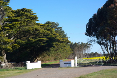
Photograph - Photograph - Colour, Entrance to Baangal, 2014, 07/09/2014
... Baangal is in the Victorian County of Ripon. ...Ballarat Heritage Services PO Box 2209 Bakery Hill Post Office goldfields Baangal is in the Victorian County of Ripon. baangal Colour photographs showing the gates to the property known as Baangal in Victoria Entrance to Baangal, 2014 Photograph Photograph - Colour ...Baangal is in the Victorian County of Ripon. Colour photographs showing the gates to the property known as Baangal in Victoriabaangal -
 Federation University Historical Collection
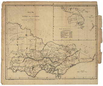
Map, Robert Brough Smyth, Sketch Map of the Colony of Victoria, c1871, c1872
... Barker Library (top floor) Mount Helen goldfields victoria victorian counties robert brough-smyth telegraph population bourke rodney dalhousie evelyn mornington buln-buln tanjil dargo delatite moira bogong bendigo gunbower grant talbot hampden heytesbury polwarth ripon kara-kara gladstone grenville croajingolong tambo benambra This map includes the population of each County in Victoria according to the 1871 Census, as well as the population of each Australian colony and New Zealand. ...This map includes the population of each County in Victoria according to the 1871 Census, as well as the population of each Australian colony and New Zealand. Telegraph Route is given in a detail at the top right. victoria, victorian counties, robert brough-smyth, telegraph, population, bourke, rodney, dalhousie, evelyn, mornington, buln-buln, tanjil, dargo, delatite, moira, bogong, bendigo, gunbower, grant, talbot, hampden, heytesbury, polwarth, ripon, kara-kara, gladstone, grenville, croajingolong, tambo, benambra -
 Federation University Historical Collection
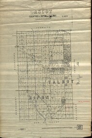
Plan - map, Ascot: Counties of Ripon and Talbot, 18/12/1920
... Photo-Lithographed at the Dept. of Lands and Survey. Ascot: Counties of Ripon and Talbot Plan map W.J.Butson ...Cadastral map showing parish boundaries and land ownership. "L5270"Maps parishes located in Ascot area. Photo-Lithographed at the Dept. of Lands and Survey.Highlighted parish labelled, Mrs E.C.Sutherland.parish, map, ascot, counties, e. c. sutherland, a. cameron, sweeney, w. j. clarke, mount hollowback, tourello, burrumbeet, glendaruel, dowling forest, a. j. mullett, w. j. butson, 1920, william coghill, chatham, chatham family collection, mrs e.c.sutherland. -
 Whitehorse Historical Society Inc.
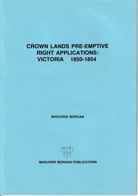
Administrative record - Crown Land Valuations and Applications, Government Printer - John FERRES, Crown Lands Pre-emptive Right Applications: Victoria 1850-1854, 1855
... Applications relate to early settlement in the 1850's in Victoria CLARKE Andrew Anglesey Evelyn Bourke Dalhousie Dundas Follett Grant Hampden Heytesbury Normanby Polwarth Ripon Talbot Villiers District of Murray District of Wimmera District of Western Port Early Settlement Mornington Contains a valuation for Crown Lands applications under pre-emptive right by Victorian county, giving names of applicants name of run, area, and remarks. ...Contains a valuation for Crown Lands applications under pre-emptive right by Victorian county, giving names of applicants name of run, area, and remarks.Contains a valuation for Crown Lands applications under pre-emptive right by Victorian county, giving names of applicants name of run, area, and remarks. Contains a valuation for Crown Lands applications under pre-emptive right by Victorian county, giving names of applicants name of run, area, and remarks. clarke andrew, anglesey, evelyn, bourke, dalhousie, dundas, follett, grant, hampden, heytesbury, normanby, polwarth, ripon, talbot, villiers, district of murray, district of wimmera, district of western port, early settlement, mornington -
 Federation University Historical Collection
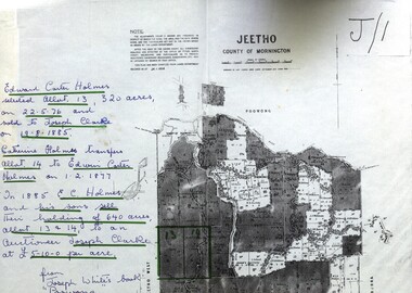
Map - Documents, Documents relating to Land - Selection of Maps of subdivisions; Titles; Cemetery sections
... county of mornington...edward carter holmes...joseph clarke...catherine holmes...talbot...william coghill...pre-emptive right...tourello pre-emptive right...glendonald pre-emptive right...clunes...smeaton...ascot...counties of ripon...Maps indicate the land owned in various areas of Victoria - Mornington Peninsula, Ascot / Creswick area jeetho county of mornington edward carter holmes joseph clarke catherine holmes talbot william coghill pre-emptive right tourello pre-emptive right glendonald pre-emptive right clunes smeaton ascot counties of ripon and talbot certificate of title ballaarat general cemetery new cemetery Poowong Helen Coghill Land maps showing block divisions and owners. ...Maps indicate the land owned in various areas of Victoria - Mornington Peninsula, Ascot / Creswick areaLand maps showing block divisions and owners. Edward Carter Holmes J.P. selected land and called it Launchley - later called Wambalano.jeetho, county of mornington, edward carter holmes, joseph clarke, catherine holmes, talbot, william coghill, pre-emptive right, tourello pre-emptive right, glendonald pre-emptive right, clunes, smeaton, ascot, counties of ripon and talbot, certificate of title, ballaarat general cemetery, new cemetery, poowong, helen coghill