Showing 59 items matching "crater"
-
 Ballarat Heritage Services
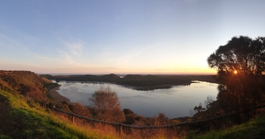
Photograph, Clare Gervasoni, Tower Hill Crater, 11/09/2020
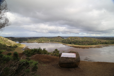
... Tower Hill Crater......crater...Tower hill is a dormant volcano, with associated conical hills, large and small craters, basalt outcrops from lava flows and layers of Ash from long ago eruptions. ...Panorama of the crater at Tower Hill...Tower Hill crater volcano Panorama of the crater at Tower Hill Tower Hill Crater Photograph Clare Gervasoni ...Tower Hill is 18km west of Warrnambool and is accessed from the Princes Highway. Tower hill is a dormant volcano, with associated conical hills, large and small craters, basalt outcrops from lava flows and layers of Ash from long ago eruptions. Panorama of the crater at Tower Hilltower hill, crater, volcano -
 Ballarat Heritage Services
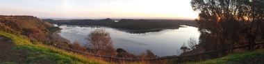
Photograph, Clare Gervasoni, Tower Hill Crater, 11/09/2020
... Tower Hill Crater......crater...Tower hill is a dormant volcano, with associated conical hills, large and small craters, basalt outcrops from lava flows and layers of Ash from long ago eruptions. ...Panorama of the crater at Tower Hill...Tower Hill crater volcano Panorama of the crater at Tower Hill Tower Hill Crater Photograph Clare Gervasoni ...Tower Hill is 18km west of Warrnambool and is accessed from the Princes Highway. Tower hill is a dormant volcano, with associated conical hills, large and small craters, basalt outcrops from lava flows and layers of Ash from long ago eruptions. Panorama of the crater at Tower Hilltower hill, crater, volcano -
 Ballarat Heritage Services
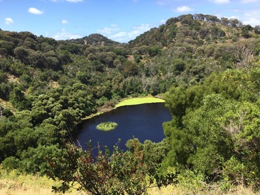
Photograph - Colour, Volcanic Crater at Tower Hill, 2017, 2017
... Volcanic Crater at Tower Hill, 2017......crater...Violent explosions followed creating a shallow crater which later filled with water to form the lake. ...Colour photographs of a lake in a volcanic crater at Tower Hill, Victoria. ...Volcanic Crater at Tower Hill, 2017 Photograph - Colour Clare Gervasoni ...Tower Hill is a volcanic formation believed to have erupted about 32,000 years ago. Its formation is known as a "nested maar" and it is the largest example of its type in Victoria. During formation, molten lava pushed its way up through the Earth’s crust and encountered a layer of water-bearing rock. Violent explosions followed creating a shallow crater which later filled with water to form the lake. Further eruptions occurred in the centre of this crater, creating the islands and cone shaped hills. In 1892 Tower Hill became Victoria’s first National Park. In 1961, Tower Hill became a State Game Reserve under the then Fisheries and Wildlife Department and a major re-vegetation program began. (https://www.towerhill.org.au/index.php/about-reserve/history, accessed 23 December 2019)Colour photographs of a lake in a volcanic crater at Tower Hill, Victoria. volcano, crater, lake, tower hill -
 National Vietnam Veterans Museum (NVVM)
Photograph, Balmoral At Peace With The Remnants Of A B52 Crater
... Balmoral At Peace With The Remnants Of A B52 Crater...Balmoral at Peace with the remnants of a B52 bomb crater. 2. Coral, at Peace and as it is now...Balmoral at Peace with the remnants of a B52 crater....Balmoral at Peace with the remnants of a B52 bomb crater. 2. Coral, at Peace and as it is now Balmoral At Peace With The Remnants Of A B52 Crater Photograph Photograph ...Two coloured Photograph in a black frame with white matting 1. Balmoral at Peace with the remnants of a B52 bomb crater. 2. Coral, at Peace and as it is nowBalmoral at Peace with the remnants of a B52 crater.photograph, balmoral collection, battle of coral-balmoral -
 National Vietnam Veterans Museum (NVVM)
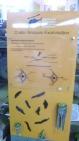
Sign, Crater Analysis Examination
... Crater Analysis Examination...Large sign Crater Analysis Examination. the bearing from which the shell/rocket arrived. the angle of descent - collect fragments, so what type of projectile. sign has mortars, shell fragments attached. ...Crater Analysis Examination...National Vietnam Veterans Museum (NVVM) 25 Veterans Drive Newhaven phillip-island-and-the-bass-coast Crater Analysis Sign Sign Crater Analysis Examination Large sign Crater Analysis Examination. the bearing from which the shell/rocket arrived. the angle of descent - collect fragments, so what type of projectile. sign has mortars, shell fragments attached. ...Large sign Crater Analysis Examination. the bearing from which the shell/rocket arrived. the angle of descent - collect fragments, so what type of projectile. sign has mortars, shell fragments attached. Sign is yellow background with black writing on it.Crater Analysis Examinationcrater analysis sign, sign -
![Interior of the crater at Mount Franklin / [by] Nicholas Caire, circa 1876](/media/collectors/550653872162f11fb04854aa/items/577b5e58d0cdd10948d30390/item-media/577b5ec3d0cdd10948d34bee/item-fit-380x285.jpg?cb=6) Kew Historical Society Inc
Kew Historical Society IncPhotograph, Anglo-Australasian Photographic Company, Interior of the crater at Mount Franklin, c. 1876
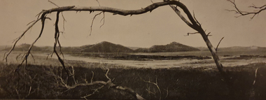
... Interior of the crater at Mount Franklin...Views of Victoria (General Series) No.33 / ‘Interior of the crater at Mount Franklin’ / Albumen silver photograph mounted on card...Looking down from the summit, the large gum trees growing at the bottom of the Crater appear but small saplings.’...Looking down from the summit, the large gum trees growing at the bottom of the Crater appear but small saplings.’ Views of Victoria (General Series) No.33 / ‘Interior of the crater at Mount Franklin’ / Albumen silver photograph mounted on card Interior of the crater at Mount Franklin Photograph Photograph Anglo-Australasian Photographic Company ...Nicholas Caire was born on Guernsey in the Channel Islands in 1837. He arrived in Adelaide with his parents in about 1860. In 1867, following photographic journeys in Gippsland, he opened a studio in Adelaide. From 1870 to 1876 he lived and worked in Talbot in Central Victoria. In 1876 he purchased T. F. Chuck's studios in the Royal Arcade Melbourne. In 1885, following the introduction of dry plate photography, he began a series of landscape series, which were commercially successful. As a photographer, he travelled extensively through Victoria, photographing places few of his contemporaries had previously seen. He died in 1918. Reference: Jack Cato, 'Caire, Nicholas John (1837–1918)', Australian Dictionary of Biography.An original, rare photograph from the series 'Views of Victoria: General Series' by the photographer, Nicholas Caire (1837-1918). The series of 60 photographs that comprise the series was issued c. 1876 and reinforced a neo-Romantic view of the Australian landscape to which a growing nationalist movement would respond. Nicholas Caire was active as a photographer in Australia from 1858 until his death in 1918. His vision of the Australian bush and pioneer life had a counterpart in the works of Henry Lawson and other nationalist poets, authors and painters.Views of Victoria (General Series) No.33 / ‘Interior of the crater at Mount Franklin’ / Albumen silver photograph mounted on cardOn Reverse: ‘Mount Franklin is situated near Malmsbury, about ten or twelve miles distant. The most remarkable and interesting part of this Mountain is its Crater, which, from its immense size and great depth, denotes that a volcanic eruption of considerable magnitude must have taken place at some period in the past. Looking down from the summit, the large gum trees growing at the bottom of the Crater appear but small saplings.’nicholas caire (1837-1918), mount franklin, victoria - landscape photography -
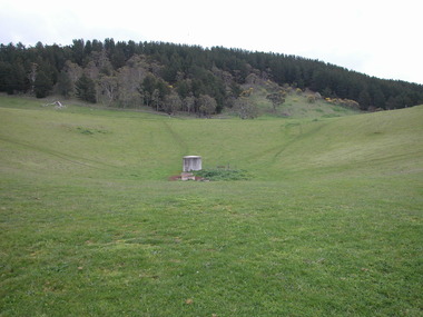
 Victorian Interpretive Projects Inc.
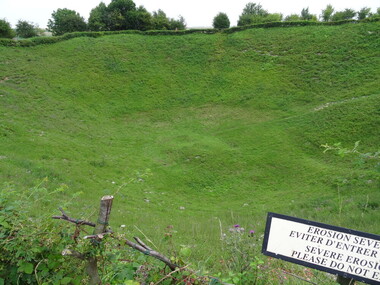
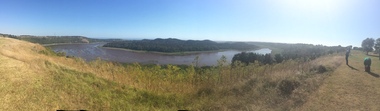
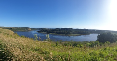
Photograph - Colour, Ann Gervasoni, Lochnagar Crater, 2014, 23/07/2017
... Lochnagar Crater, 2014...The attack on either flank was defeated by German small-arms and artillery fire, except on the extreme right flank and just south of La Boisselle, north of the Lochnagar Crater. The crater has been preserved as a memorial and a religious service is held each 1 July. ...A number of photographs of a crater which was created at the Somme, on the Western Front during World War One. ...Lochnagar Crater, 2014 Photograph - Colour Ann Gervasoni ...The mine was named after Lochnagar Street, the British trench from which the gallery was driven. It was one of 19 mines that were placed beneath the German lines on the British section of the Somme front to assist the infantry advance at the start of the battle. The Lochnagar mine was sprung at 7:28 a.m. on 1 July 1916 and left a crater 98 ft (30 m) deep and 330 ft (100 m) wide, which was captured and held by British troops. The attack on either flank was defeated by German small-arms and artillery fire, except on the extreme right flank and just south of La Boisselle, north of the Lochnagar Crater. The crater has been preserved as a memorial and a religious service is held each 1 July. (Wikipedia)A number of photographs of a crater which was created at the Somme, on the Western Front during World War One. lochnagar crater, tunnellers, the somme, world war one, western front, france -
 National Vietnam Veterans Museum (NVVM)
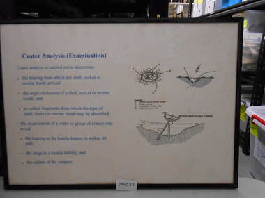
Document, Crater Analysis ( Examination)
... Crater Analysis ( Examination)...Framed Document with sketches on how to analyse a bomb crater....National Vietnam Veterans Museum (NVVM) 25 Veterans Drive Newhaven phillip-island-and-the-bass-coast Framed document Crater Analysis Sign Framed Document with sketches on how to analyse a bomb crater. ...Framed Document with sketches on how to analyse a bomb crater.framed document, crater analysis sign -
 National Vietnam Veterans Museum (NVVM)
Photograph, The Crater made by the blast: Image No. 2, 1970
... The Crater made by the blast: Image No. 2....B/W photo of an APC & a Centurion Tank. 11 Australian soldiers standing around looking at the crater made by the blast....National Vietnam Veterans Museum (NVVM) 25 Veterans Drive Newhaven phillip-island-and-the-bass-coast Operation Massey Harris Armoured Personnel Carrier Denis Gibbons Centurion tank Anti Tank Mine Australian War Memorial: PO4665.981 B/W photo of an APC & a Centurion Tank. 11 Australian soldiers standing around looking at the crater made by the blast. The Crater made by the blast: Image No. 2. ...B/W photo of an APC & a Centurion Tank. 11 Australian soldiers standing around looking at the crater made by the blast.Australian War Memorial: PO4665.981operation massey harris, armoured personnel carrier, denis gibbons, centurion tank, anti tank mine -
 Federation University Art Collection
Work on paper - Artwork - Printmaking, Jack, Kenneth, 'Mt Eccles and Crater Lake, No.3 Volcanic Plains of Victoria ' by Kenneth Kack, 1961
... 'Mt Eccles and Crater Lake, No.3 Volcanic Plains of Victoria ' by Kenneth Kack...Framed four plate lithograph depicitng Nt Eccles and Crater Lake on the Victorian cvolcanic plains. ...Donated through the Australian Gifts Programme by Katherine Littlewood. 'Mt Eccles and Crater Lake, No.3 Volcanic Plains of Victoria ' by Kenneth Kack Work on paper Artwork - Printmaking Jack, Kenneth ...Framed four plate lithograph depicitng Nt Eccles and Crater Lake on the Victorian cvolcanic plains. Donated through the Australian Gifts Programme by Katherine Littlewood.Edition 23/42kenneth jack, printmaking, mt eccles, volcano, lithograph -
 Inverloch Historical Society
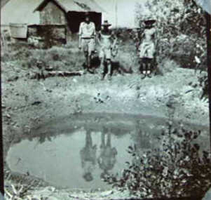
000546 - Photograph - Bomb Crater - Tack Fred - Danny - C Newton
... 000546 - Photograph - Bomb Crater - Tack Fred - Danny - C Newton...Inverloch gippsland 000546 - Photograph - Bomb Crater - Tack Fred - Danny - C Newton ... -
 Horsham Regional Art Gallery
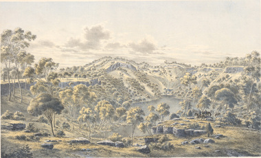
Print - Photograph, Eugene von GUERARD, Crater of Mount Eccles, Victoria, 1867
... Crater of Mount Eccles, Victoria...Horsham Regional Art Gallery 80 Wilson Street Horsham grampians Crater of Mount Eccles, Victoria Print Photograph Eugene von GUERARD Hamel and Ferguson, Melbourne ...Purchases through the Horsham Art Gallery Trust Fund, 2008 -
 Victorian Interpretive Projects Inc.
Photograph - Colour, Ann Gervasoni, De Palingbeek, 21/07/2014
... ...crater...A number of photographs showing the De Palingbeek crater which was created during World War One. ...PO Box 93R, Redan, 3350 goldfields De Palingbeek crater world war one Hill 60 Hill60 A number of photographs showing the De Palingbeek crater which was created during World War One. ...A number of photographs showing the De Palingbeek crater which was created during World War One. de palingbeek, crater, world war one, hill 60, hill60 -
 Dandenong/Cranbourne RSL Sub Branch
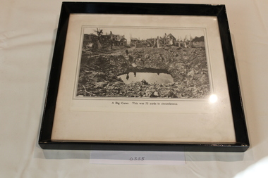
Photograph - Framed Photograph
... Photograph inscribed "A Big Crater." Photograph shows a bomb crater 75 yards in circumference....Dandenong/Cranbourne RSL Sub Branch 44 – 50 Clow Street Dandenong melbourne Photograph inscribed "A Big Crater." Photograph shows a bomb crater 75 yards in circumference. ...Black painted wooden framed black & white photograph.Photograph inscribed "A Big Crater." Photograph shows a bomb crater 75 yards in circumference. -
 Ballarat Heritage Services
Photograph - Image, Tower Hill, Victoria, c1918, c1918
... ...crater...Violent explosions followed creating a shallow crater which later filled with water to form the lake. ...Violent explosions followed creating a shallow crater which later filled with water to form the lake. ...Tower Hill is a volcanic formation believed to have erupted about 32,000 years ago. Its formation is known as a "nested maar" and it is the largest example of its type in Victoria. During formation, molten lava pushed its way up through the Earth’s crust and encountered a layer of water-bearing rock. Violent explosions followed creating a shallow crater which later filled with water to form the lake. Further eruptions occurred in the centre of this crater, creating the islands and cone shaped hills. In 1892 Tower Hill became Victoria’s first National Park. In 1961, Tower Hill became a State Game Reserve under the then Fisheries and Wildlife Department and a major re-vegetation program began. (https://www.towerhill.org.au/index.php/about-reserve/history, accessed 23 December 2019)Black and white image of Tower Hill, near Koroit, Victoria.tower hill, volcano, crater -
 Ballarat Heritage Services
Photograph - Colour photograph, Tower Hill, 2016, 23/12/2015
... ...crater...Violent explosions followed creating a shallow crater which later filled with water to form the lake. ...Violent explosions followed creating a shallow crater which later filled with water to form the lake. ...Tower Hill is a volcanic formation believed to have erupted about 32,000 years ago. Its formation is known as a "nested maar" and it is the largest example of its type in Victoria. During formation, molten lava pushed its way up through the Earth’s crust and encountered a layer of water-bearing rock. Violent explosions followed creating a shallow crater which later filled with water to form the lake. Further eruptions occurred in the centre of this crater, creating the islands and cone shaped hills. In 1892 Tower Hill became Victoria’s first National Park. In 1961, Tower Hill became a State Game Reserve under the then Fisheries and Wildlife Department and a major re-vegetation program began. (https://www.towerhill.org.au/index.php/about-reserve/history, accessed 23 December 2019)Panaramic view of Tower Hill, Victoria.tower hill, volcano, crater -
 Ballarat Heritage Services
Photograph - Colour photograph, Tower Hill, 2022, 24/12/2022
... ...crater...Violent explosions followed creating a shallow crater which later filled with water to form the lake. ...Violent explosions followed creating a shallow crater which later filled with water to form the lake. ...Tower Hill is a volcanic formation believed to have erupted about 32,000 years ago. Its formation is known as a "nested maar" and it is the largest example of its type in Victoria. During formation, molten lava pushed its way up through the Earth’s crust and encountered a layer of water-bearing rock. Violent explosions followed creating a shallow crater which later filled with water to form the lake. Further eruptions occurred in the centre of this crater, creating the islands and cone shaped hills. In 1892 Tower Hill became Victoria’s first National Park. In 1961, Tower Hill became a State Game Reserve under the then Fisheries and Wildlife Department and a major re-vegetation program began. (https://www.towerhill.org.au/index.php/about-reserve/history, accessed 23 December 2019)Panaramic view of Tower Hill, Victoria.tower hill, volcano, crater -
 Running Rabbits Military Museum operated by the Upwey Belgrave RSL Sub Branch
Photo
... Bomb craters with lonely cross...Running Rabbits Military Museum operated by the Upwey Belgrave RSL Sub Branch 1 Mast Gully Road Upwey melbourne Photo Bomb craters with lonely cross Photo ...Bomb craters with lonely crossphoto -
 Ballarat Heritage Services
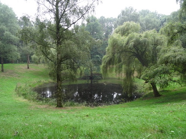
Digital photographs, L.J. Gervasoni, Lake at Tower Hill, c2015
... Colour photographs of Tower Hill and the crater lake....Ballarat Heritage Services PO Box 2209 Bakery Hill Post Office goldfields Tower Hill is an extinct volcano in the Western District of Victoria. tower hill volcano natural heritage koroit lake landscape Colour photographs of Tower Hill and the crater lake. Lake at Tower Hill Digital photographs L.J. ...Tower Hill is an extinct volcano in the Western District of Victoria.Colour photographs of Tower Hill and the crater lake.tower hill, volcano, natural heritage, koroit, lake, landscape -
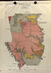
 Federation University Historical Collection
Plan - Map, Mines Department, Parish of Narmbool and part of Cargerie, County of Grant, 1892, 06/1992
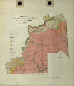
... ...crater...This map shows the position of the homestead on the Narmbool Pre-emptive Right, volcanic craters, stock reserve, quarry and geological eras,...This map shows the position of the homestead on the Narmbool Pre-emptive Right, volcanic craters, stock reserve, quarry and geological eras, narmbool cargerie narmbool pre-emptive right williamson's creek leigh river green hill collyer's hill volcano crater krause ferdinand krause Geological map showing Narmbool and part of Cargerie in the County of Grant in five colours, predominantly pink. ...This map shows the position of the homestead on the Narmbool Pre-emptive Right, volcanic craters, stock reserve, quarry and geological eras,Geological map showing Narmbool and part of Cargerie in the County of Grant in five colours, predominantly pink.narmbool, cargerie, narmbool pre-emptive right, williamson's creek, leigh river, green hill, collyer's hill, volcano, crater, krause, ferdinand krause -
 Warrnambool RSL Sub Branch
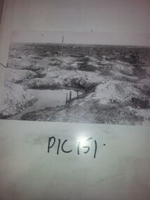
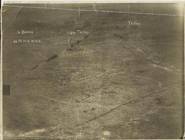
AERIAL PHOTOGRAPH, (Oblique shot of battlefield) 30/9/1916, LE BARQUE...... LIGNY THILLOY....... THILLOY, 22.N.1514
... Sepia photograph, showing trench lines, gun emplacements, landscape peppered with shell craters....Snape Collection Sepia photograph, showing trench lines, gun emplacements, landscape peppered with shell craters. LE BARQUE...... LIGNY THILLOY....... ...Original Item recovered from possibly Australian Corps HQ, probably between the Armistice, 11 November 1918, and June 1919, when the Staff Sergeant R.O.(Bob) Snape was repatriated.Sepia photograph, showing trench lines, gun emplacements, landscape peppered with shell craters.snape collection -
 Victorian Interpretive Projects Inc.
Photograph - Colour, Clare Gervasoni, Tower Hill Interpretation Centre by Robin Boyd, 2015, 25/12/2015
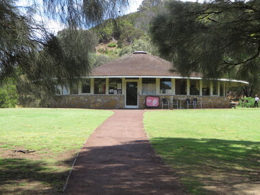
... interpretation centre in the crater of Tower Hill near Koroit. The centre was designed by Robin Boyd....PO Box 93R, Redan, 3350 goldfields Tower Hill Tower Hill Interpretation Centre Robin Boyd interpretation centre in the crater of Tower Hill near Koroit. The centre was designed by Robin Boyd. ...interpretation centre in the crater of Tower Hill near Koroit. The centre was designed by Robin Boyd.tower hill, tower hill interpretation centre, robin boyd -
 Federation University Historical Collection
Map - Plan, E.J. Dunn, Bungal County of Grant Parish Plan
... The areas circled in red ar craters....The areas circled in red ar craters. Bungal County of Grant Parish Plan Map Plan E.J. ...E.J. Dunn was the surveyor of this parish plan.Colour geological plan of Bungal in the County of Grant, Victoria. The areas circled in red ar craters.plan, bungal, bungeltap, black horse co. egerton, egerton, mount egerton, sister rose shaft, south learmonth co, kerrit bareet, bungaeeltap, yaloak, eastern moorabool river, corong, bungal station preemptive right, lal lal, western moorabool river, moorabool rover, borhoneychurck, mount egerton battery, bungal creek -
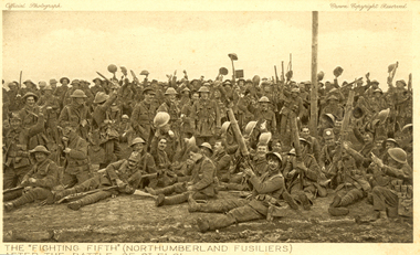 Federation University Historical Collection
Postcard - Sepia, The "Fighting Fifth" after the Battle of St Eloi, c1916
... ...crater...Holmes Family WW1 memorabilia. 06 Apr 1916 - The Battle of St Eloi Craters, Canadian Expeditionary Forces Major Operation. “… the British had been patiently tunnelling since August (1915) at nearby St Eloi, about three miles south of Ypres, and adjacent to the Canadian trenches. ...Two German companies were wiped out and large sections of the German trenches were destroyed, but the British 9th Brigade’s attack faltered and became a bloody close-quarters slugging match, with the last bomb crater captured only on April 3.” (Zuehlke, Mark. ...Holmes Family WW1 memorabilia. 06 Apr 1916 - The Battle of St Eloi Craters, Canadian Expeditionary Forces Major Operation. “… the British had been patiently tunnelling since August (1915) at nearby St Eloi, about three miles south of Ypres, and adjacent to the Canadian trenches. Throughout the winter, the tunnelling crept ever closer to a dominant German-held feature dubbed “The Mound.” When the tunnels were completed in early March, tons of explosives were emplaced in six locations and on March 27, 1916, at 4:14 a.m. the charges were set off. Two German companies were wiped out and large sections of the German trenches were destroyed, but the British 9th Brigade’s attack faltered and became a bloody close-quarters slugging match, with the last bomb crater captured only on April 3.” (Zuehlke, Mark. Daniel, C. Stuart. The Canadian Military Atlas. The Nation’s Battlefields from the French and Indian Wars to Kosovo. Stoddart Publishing Co. Limited. Toronto. 2001 p. 125)A number of World War One soldiers, members of the Northumberland Fusiliers celebrate after the battle of St Eloi. Some or wear tin helmuts.The "Fighting Fifth" (Northumberland Fusiliers) after the battle of St Eloi"chatham-holmes family collection, fighting fifth, northumberland fusiliers, tunneling, explosion, crater, world war one, postcard -
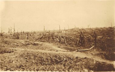 Bendigo Historical Society Inc.
Postcard - ACC LOCK COLLECTION: SEPIA PHOTO OF A WW1 BATTLEGROUND, POSTCARD, 1914-1918
... Postcard, WW1, Sepia photo of the aftermath of a battle ground. Craters and burnt out trees. Handwritten in pencil on back 'Pozieres'...History House 11 Mackenzie Street Bendigo goldfields POSTCARD Postcard WW1 battleground Postcard, WW1, Sepia photo of the aftermath of a battle ground. Craters and burnt out trees. Handwritten in pencil on back 'Pozieres' Postcard ACC LOCK COLLECTION: SEPIA PHOTO OF A WW1 BATTLEGROUND, POSTCARD ...Postcard, WW1, Sepia photo of the aftermath of a battle ground. Craters and burnt out trees. Handwritten in pencil on back 'Pozieres'postcard, postcard, ww1, battleground -
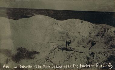 Bendigo Historical Society Inc.
Postcard - ACC LOCK COLLECTION: LA BOISELLE - THE MINE CRATER NEAR THE POZIERES ROAD, POSTCARD, BRITISH MADE, 1914-1918
... Postcard, WW1, B&W image of a mine crater at Boiselle near the Pozieres Road. Timbers and a figure in front of a tunnel opening...History House 11 Mackenzie Street Bendigo goldfields POSTCARD Postcard WW1 France La Boiselle mine crater Pozieres Postcard, WW1, B&W image of a mine crater at Boiselle near the Pozieres Road. ...Postcard, WW1, B&W image of a mine crater at Boiselle near the Pozieres Road. Timbers and a figure in front of a tunnel openingpostcard, postcard, ww1, france, la boiselle, mine crater, pozieres -
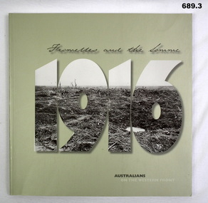 Bendigo Military Museum
Book, Department of Veteran's Affairs, Fromelles and the Somme 1916 - Australians on the Western Front, 2006
... .1 Hardcover book, grey with black and white photo of cratered landscape inset into "1916" title. .2 Donation letter. .3 Errata....Bendigo Military Museum 37 - 39 Pall Mall Bendigo goldfields books military history .1 Hardcover book, grey with black and white photo of cratered landscape inset into "1916" title. .2 Donation letter. .3 Errata. ....1 Hardcover book, grey with black and white photo of cratered landscape inset into "1916" title. .2 Donation letter. .3 Errata.books, military history -
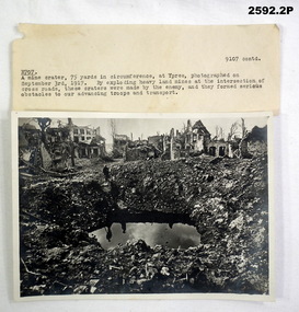 Bendigo Military Museum
Photograph - PHOTOGRAPH WW1, original 1917
... .1) Note, typed in ink with description of .2). .2) Photograph, black & white, showing a mine crater 75 yards circumferance at Ypres 1917....Williams DSO, refer cat No 2580. photography-photographs documents - notes military history craters mines .1) Note, typed in ink with description of .2). .2) Photograph, black & white, showing a mine crater 75 yards circumferance at Ypres 1917. ...Item in the collection re Brig E.M. Williams DSO, refer cat No 2580..1) Note, typed in ink with description of .2). .2) Photograph, black & white, showing a mine crater 75 yards circumferance at Ypres 1917.photography-photographs, documents - notes, military history, craters, mines -
 Ballarat Heritage Services
Photograph - Colour photograph, Volcanic Vent Near Mount Franklin, 2007, 18/07/2016
... When the ground depresses down at the point of a volcanic vent after a volcano’s magma chamber has been emptied it is known as a caldera, and not a volcano crater. (https://www.universetoday.com/31143/volcano-crater/, accessed 04 March 2019) A caldera is a volcanic feature formed by the collapse of a volcano into itself, making it a large, special form of volcanic crater. ...Ballarat Heritage Services PO Box 2209 Bakery Hill Post Office goldfields When the ground depresses down at the point of a volcanic vent after a volcano’s magma chamber has been emptied it is known as a caldera, and not a volcano crater. (https://www.universetoday.com/31143/volcano-crater/, accessed 04 March 2019) A caldera is a volcanic feature formed by the collapse of a volcano into itself, making it a large, special form of volcanic crater. ...When the ground depresses down at the point of a volcanic vent after a volcano’s magma chamber has been emptied it is known as a caldera, and not a volcano crater. (https://www.universetoday.com/31143/volcano-crater/, accessed 04 March 2019) A caldera is a volcanic feature formed by the collapse of a volcano into itself, making it a large, special form of volcanic crater. A caldera collapse is usually triggered by the emptying of the magma chamber beneath the volcano, as the result of a large volcanic eruption.(https://www.sciencedaily.com/terms/caldera.htm)A volcanic vent, or depression on one side of Mount Franklin. mount franklin, volcano, volcanic vent, lalgambook -
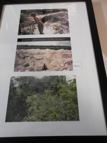 National Vietnam Veterans Museum (NVVM)
Photograph
... CPL Mancer in a BE2-Bomb Crater 3. FSB Coral clearing enemy bunker 25th May 1968...CPL Mancer in a BE2-Bomb Crater 3. FSB Coral clearing enemy bunker 25th May 1968 Photograph Photograph ...Three coloured Photograph in black frame with white matting 1. PTE John Bryant inspecting push bike 2. CPL Mancer in a BE2-Bomb Crater 3. FSB Coral clearing enemy bunker 25th May 1968photograph, pte john bryant, cpl mancer, b52-bomb crater, clearing bunker, battle of coral-balmoral