Showing 179 items matching "culverts"
-
 Ringwood and District Historical Society
Photograph, Earth fill over culverts in place of old Warrandyte Road bridge, Ringwood 1986
... Earth fill over culverts in place of old Warrandyte Road bridge, Ringwood 1986...Earth fill over culverts in place of old Warrandyte Road bridge."...Earth fill over culverts in place of old Warrandyte Road bridge." ...Written on back of photograph, "29.22.86. Earth fill over culverts in place of old Warrandyte Road bridge." -
 Ballarat Tramway Museum
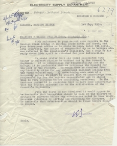
Document - Letter/s, State Electricity Commission of Victoria (SECV), "Tramways - Tracks over bridges, culverts etc.", Aug. 1957
... "Tramways - Tracks over bridges, culverts etc."...Memo with attached letter dated 1/5/191, titled "Tramways - Tracks over bridges, culverts etc." regarding repairs to the Bendigo Creek Bridge at Charing Cross and responsibility of costs for repairs - SEC or City of Bendigo. ..."Tramways - Tracks over bridges, culverts etc." Document Letter/s State Electricity Commission of Victoria (SECV) ...Yields information about the correspondence that was involving damage to the Charing cross bridge in Bendigo and responsibilities for repair.Memo with attached letter dated 1/5/191, titled "Tramways - Tracks over bridges, culverts etc." regarding repairs to the Bendigo Creek Bridge at Charing Cross and responsibility of costs for repairs - SEC or City of Bendigo. Letter from Dooley and Breen Solicitors, dated 26/4/1951 regarding responsibilities, refer to original agreements. Was pinned the top left hand corner.Has initials in ink.trams, tramways, letters, sec, tram track, pmg -
 Marysville & District Historical Society
Photograph (Item) - Black and white photograph, Unknown
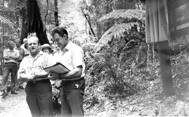
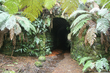
... A black and white photograph taken at the unveiling of the sign placed at The Big Culvert....A black and white photograph taken at the unveiling of the sign placed at The Big Culvert....Unveiling of sign/ at "Big Culvert" In front Max Cockerrell and - Rear: second back Geoff Pope R.H.S. rear: Nancy "/ Anne "...Marysville & District Historical Society 39 Darwin Street Marysville yarra-valley-and-the-dandenong-ranges A black and white photograph taken at the unveiling of the sign placed at The Big Culvert. A black and white photograph taken at the unveiling of the sign placed at The Big Culvert. ...A black and white photograph taken at the unveiling of the sign placed at The Big Culvert.A black and white photograph taken at the unveiling of the sign placed at The Big Culvert. The Big Culvert is a historic granite and bluestone arch along the Yarra Track, a major route to Melbourne through the 1800s. Built in 1870 and a major piece of infrastructure for its time, the heritage listed culvert allowed water to flow under often-flooded the road. The Yarra Track is the former name of the gold fields road from Healesville to the Woods Point and Jordan Goldfields, in Victoria, Australia. A direct route via the Yarra River and the Great Divide was discovered by Rieck in September 1862 and became known as the Yarra Track. Early in 1863, the Victorian Government decided to construct a 193-kilometre (120 mile) road along the route. Its original width varied between 4 and 6 metres (12 and 20 feet), and was designed to accommodate horse-drawn vehicles. The Track involved the climbing of the Black Spur, descent into the Acheron Valley, and then through Marysville to the Cumberland where it followed the existing route.Unveiling of sign/ at "Big Culvert" In front Max Cockerrell and - Rear: second back Geoff Pope R.H.S. rear: Nancy "/ Anne "the big culvert, yarra track, victoria, healesville, wood's point goldfields, jordan goldfields, black spur, acheron valley, cumberland valley -
 Ringwood and District Historical Society
Photograph, Concrete culverts for new bridge. Warrandyte Rd. Ringwood 1986 (2 Views)
... Concrete culverts for new bridge. Warrandyte Rd. Ringwood 1986 (2 Views)...SS0369h shows plants of Barrett's old garden. Concrete culverts for new bridge. Warrandyte Rd. Ringwood 1986 (2 Views) Photograph ...Written on back of photograph, "for new bridge. Warrandyte Rd. 1986." SS0369h shows plants of Barrett's old garden. -
 Marysville & District Historical Society
Photograph (Item) - Colour photograph, 20-09-2008
... A colour photograph of the entrance to The Big Culvert....A colour photograph of the entrance to The Big Culvert....Marysville & District Historical Society 39 Darwin Street Marysville yarra-valley-and-the-dandenong-ranges A colour photograph of the entrance to The Big Culvert. A colour photograph of the entrance to The Big Culvert. ...A colour photograph of the entrance to The Big Culvert.A colour photograph of the entrance to The Big Culvert. The Big Culvert is a historic granite and bluestone arch along the Yarra Track, a major route to Melbourne through the 1800s. Built in 1870 and a major piece of infrastructure for its time, the heritage listed culvert allowed water to flow under often-flooded the road. The Yarra Track is the former name of the gold fields road from Healesville to the Woods Point and Jordan Goldfields, in Victoria, Australia. A direct route via the Yarra River and the Great Divide was discovered by Rieck in September 1862 and became known as the Yarra Track. Early in 1863, the Victorian Government decided to construct a 193-kilometre (120 mile) road along the route. Its original width varied between 4 and 6 metres (12 and 20 feet), and was designed to accommodate horse-drawn vehicles. The Track involved the climbing of the Black Spur, descent into the Acheron Valley, and then through Marysville to the Cumberland where it followed the existing route.the big culvert, yarra track, victoria, healesville, wood's point goldfields, jordan goldfields, black spur, acheron valley, cumberland valley -
 Marysville & District Historical Society
Booklet (Item) - Information booklet, Artworkz Tourism, The Big Culvert, Unknown
... The Big Culvert...An information booklet that was produced as a guide to The Big Culvert....An information booklet that was produced as a guide to The Big Culvert....The Big Culvert Booklet Information booklet Artworkz Tourism ...An information booklet that was produced as a guide to The Big Culvert.An information booklet that was produced as a guide to The Big Culvert. The Big Culvert is a historic granite and bluestone arch along the Yarra Track, a major route to Melbourne through the 1800s. Built in 1870 and a major piece of infrastructure for its time, the heritage listed culvert allowed water to flow under often-flooded the road. The Yarra Track is the former name of the gold fields road from Healesville to the Woods Point and Jordan Goldfields, in Victoria, Australia. A direct route via the Yarra River and the Great Divide was discovered by Rieck in September 1862 and became known as the Yarra Track. Early in 1863, the Victorian Government decided to construct a 193-kilometre (120 mile) road along the route. Its original width varied between 4 and 6 metres (12 and 20 feet), and was designed to accommodate horse-drawn vehicles. The Track involved the climbing of the Black Spur, descent into the Acheron Valley, and then through Marysville to the Cumberland where it followed the existing route.the big culvert, yarra track, victoria, healesville, wood's point goldfields, jordan goldfields, black spur, acheron valley, cumberland valley -
Marysville & District Historical Society
Flyer (Item) - Information flyer, Artworkz Tourism, The Big Culvert, 26-03-2016
... The Big Culvert...An information flyer that was produced as a guide to The Big Culvert....An information flyer that was produced as a guide to The Big Culvert....The Big Culvert Flyer Information flyer Artworkz Tourism ...An information flyer that was produced as a guide to The Big Culvert.An information flyer that was produced as a guide to The Big Culvert. The Big Culvert is a historic granite and bluestone arch along the Yarra Track, a major route to Melbourne through the 1800s. Built in 1870 and a major piece of infrastructure for its time, the heritage listed culvert allowed water to flow under often-flooded the road. The Yarra Track is the former name of the gold fields road from Healesville to the Woods Point and Jordan Goldfields, in Victoria, Australia. A direct route via the Yarra River and the Great Divide was discovered by Rieck in September 1862 and became known as the Yarra Track. Early in 1863, the Victorian Government decided to construct a 193-kilometre (120 mile) road along the route. Its original width varied between 4 and 6 metres (12 and 20 feet), and was designed to accommodate horse-drawn vehicles. The Track involved the climbing of the Black Spur, descent into the Acheron Valley, and then through Marysville to the Cumberland where it followed the existing route.the big culvert, yarra track, victoria, healesville, wood's point goldfields, jordan goldfields, black spur, acheron valley, cumberland valley -
 Ringwood and District Historical Society
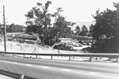
Photograph, Mullum Mullum Creek culvert installations for new bridge in Warrandyte Road, Ringwood - 19.1.1987
... Mullum Mullum Creek culvert installations for new bridge in Warrandyte Road, Ringwood - 19.1.1987....Culverts under new Warrandyte Rd. bridge. Mullum Mullum Creek, Ringwood 1987...Written on back of photograph, "9.1.87. Culverts under new Warrandyte Rd. bridge. Mullum Mullum Creek."...Culverts under new Warrandyte Rd. bridge. Mullum Mullum Creek, Ringwood 1987 Mullum Mullum Creek culvert installations for new bridge in Warrandyte Road, Ringwood - 19.1.1987. ...Culverts under new Warrandyte Rd. bridge. Mullum Mullum Creek, Ringwood 1987Written on back of photograph, "9.1.87. Culverts under new Warrandyte Rd. bridge. Mullum Mullum Creek." -
Glenelg Shire Council Cultural Collection
Photograph - Photograph - Erosion, Casterton, Victoria, n.d
... Black and white photo, showing erosion of section of gully between box culverts near Casterton...Back: Stamp - Kodak print 'GB 4243' 'Gully section between Box-Culverts near Casterton' - handwritten, pencil...Glenelg Shire Council Cultural Collection History House Cliff Street Portland great-ocean-road Sourced from Casterton Town Hall (Former Shire of Glenelg) Back: Stamp - Kodak print 'GB 4243' 'Gully section between Box-Culverts near Casterton' - handwritten, pencil Black and white photo, showing erosion of section of gully between box culverts near Casterton Photograph Photograph - Erosion, Casterton, Victoria ...Sourced from Casterton Town Hall (Former Shire of Glenelg)Black and white photo, showing erosion of section of gully between box culverts near CastertonBack: Stamp - Kodak print 'GB 4243' 'Gully section between Box-Culverts near Casterton' - handwritten, pencil -
 Marysville & District Historical Society
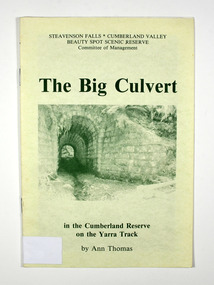
Book, Steavenson Falls-Cumberland Valley Beauty Spot Scenic Reserve Committee of Management, The Big Culvert, 1992
... The Big Culvert...A history of the Big Culvert in the Cumberland Reserve and its link to the Yarra Track...Front cover has an old photograph of the big culvert....Front cover has an old photograph of the big culvert. The Big Culvert Book Book Ann Thomas Steavenson Falls-Cumberland Valley Beauty Spot Scenic Reserve Committee of Management ...A history of the Big Culvert in the Cumberland Reserve and its link to the Yarra TrackPaperback. Front cover has an old photograph of the big culvert.Marysville, Vic. 3779./ January, 1992. Dear Reader,/ I hope you'll enjoy sharing with me an account of some of the excitement and/ drama of events through history on the old Yarra Track. This Reserve is, of course,/ in the heart of one of the world's great hardwood forests, where generations of my/ family have lived and worked./ Some levels of elevation top the 4000 ft. mark, as it is part of the Great Dividing/Range in Victoria. I have collected just a few aspects of early times and would like/ to say thanks for the encouragement I have received, to write about one of my/ favourite subjects./ Ann Thomas With Best Wishes / Ann Thomas / 12.7.92 Stamp of Marysville & District / Historical Society Inc / P.O. Box 22 / Marysville 3779big culvert, cumberland reserve, yarra track, victoria, history -
 Marysville & District Historical Society
Book, Steavenson Falls-Cumberland Valley Beauty Spot Scenic Reserve Committee of Management, The Big Culvert, 1992
... The Big Culvert...A history of the Big Culvert in the Cumberland Reserve and its link to the Yarra Track...Front cover has an old photograph of the big culvert....Front cover has an old photograph of the big culvert. The Big Culvert Book Book Ann Thomas Steavenson Falls-Cumberland Valley Beauty Spot Scenic Reserve Committee of Management ...A history of the Big Culvert in the Cumberland Reserve and its link to the Yarra TrackPaperback. Front cover has an old photograph of the big culvert.Stamp of the Marysville & District / Historical Society Inc / P.O. Box 22 / Marysville 3779big culvert, cumberland reserve, yarra track, victoria, history -
 Marysville & District Historical Society
Booklet - Paperback booklet, Ann Thomas, The Big Culvert, 1992
... The Big Culvert...A history of the Big Culvert in the Cumberland Reserve and its link to the Yarra Track....Front cover has an old photograph of the big culvert....A history of the Big Culvert in the Cumberland Reserve and its link to the Yarra Track. big culvert cumberland reserve yarra track victoria history A history of the Big Culvert in the Cumberland Reserve and its link to the Yarra Track. ...A history of the Big Culvert in the Cumberland Reserve and its link to the Yarra Track.Paperback. Front cover has an old photograph of the big culvert.non-fictionA history of the Big Culvert in the Cumberland Reserve and its link to the Yarra Track.big culvert, cumberland reserve, yarra track, victoria, history -
 Federation University Historical Collection
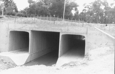
Photograph - Photograph Colour, Clare Gervasoni, Former Ballarat - Buninyong Railway Line Barrel Culvert, 1995, 2005
... Former Ballarat - Buninyong Railway Line Barrel Culvert, 1995......culvert...The culvert is in disrepair and is located at Mt Helen. ...The culvert is in disrepair and is located at Mt Helen. ....1 shows part of a the track still on locationSixteen colour photographs of a brick culvert built as part of the Ballarat - Buninyong Railway Line taken in 1995. The culvert is in disrepair and is located at Mt Helen. The culvert has bricks throughout it and creates a circular tunnel.railway, brick, train, culvert, barrel culvert -
Glenelg Shire Council Cultural Collection
Photograph - Photograph - Cape Grant Quarry, 08/07/1953
... Black and white photo showing Cape Grant quarry road culvert. 3 men inspecting culvert, several workmen on right, higher ground....Glenelg Shire Council Cultural Collection History House Cliff Street Portland great-ocean-road Port of Portland Authority Archives Port of Portland Archives Cape Grant Quarry Back: Purple PHT stamp Black and white photo showing Cape Grant quarry road culvert. 3 men inspecting culvert, several workmen on right, higher ground. ...Port of Portland Authority ArchivesBack: Purple PHT stampport of portland archives, cape grant quarry -
Glenelg Shire Council Cultural Collection
Photograph - Photograph - Cape Grant Quarry, Portland, 03/08/1953
... Black and white photo of culvert at Cape Grant Quarry....Port of Portland Archives Cape Grant Quarry harbour development construction Front: Back- Purple PHT Stamp Black and white photo of culvert at Cape Grant Quarry. Photograph Photograph - Cape Grant Quarry, Portland ...Port of Portland Authority Archives. From the Port of Portland website: Just 6km south of Portland, the Cape Grant Quarry is located on the eastern cliff of Cape Sir William Grant. This cape represents the core of a volcanic complex between two collapse calderas which underlie Nelson and Grant Bays to the west and east respectively. The Cape Grant quarry supplied an inexhaustible quantity of bluestone for the building of the new Portland harbour. The first stone was tipped at the root of the main breakwater on 17 November 1952. A small band of interested citizens were there to see the historic event. In the building, the breakwater was consolidated by the heavy traffic of Euclid’s and bulldozers and was further solidified by several storms that swept over it. Nowadays, blasting at the quarry is heavily regulated and carried out under the instructions of a qualified “powder monkey.” The days of seeing large explosions, along with the deep long loud BOOM are long gone with techniques of controlled blasting now improving overall environmental and safety standards.Front: Back- Purple PHT Stampport of portland archives, cape grant quarry, harbour development, construction -
Glenelg Shire Council Cultural Collection
Photograph - Photograph - Cape Grant Quarry, 03/08/1953
... Black and white photo of culvert at Cape Grant, looking east...Glenelg Shire Council Cultural Collection History House Cliff Street Portland great-ocean-road Port of Portland Authority Archives Port of Portland Archives Cape Grant Quarry Back: Purple PHT stamp Black and white photo of culvert at Cape Grant, looking east Photograph Photograph - Cape Grant Quarry ...Port of Portland Authority ArchivesBack: Purple PHT stampport of portland archives, cape grant quarry -
Glenelg Shire Council Cultural Collection
Photograph - Photograph - Cape Grant Quarry, 27/08/1953
... Black and white photo of Cape Grant quarry road culvert...Glenelg Shire Council Cultural Collection History House Cliff Street Portland great-ocean-road Port of Portland Authority Archives Port of Portland Archives Cape Grant Quarry Back: Purple PHT stamp Black and white photo of Cape Grant quarry road culvert Photograph Photograph - Cape Grant Quarry ...Port of Portland Authority ArchivesBack: Purple PHT stampport of portland archives, cape grant quarry -
Glenelg Shire Council Cultural Collection
Photograph, n.d
... Black and white photograph. Culvert both sides of road, erosion of paddocks...Glenelg Shire Council Cultural Collection History House Cliff Street Portland great-ocean-road Sourced from Casterton Town Hall (former Shire of Glenelg) Back: Round, purple, photographer's stamp Black and white photograph. Culvert both sides of road, erosion of paddocks Photograph Photograph J. ...Sourced from Casterton Town Hall (former Shire of Glenelg)Black and white photograph. Culvert both sides of road, erosion of paddocksBack: Round, purple, photographer's stamp -
 Ballarat Heritage Services
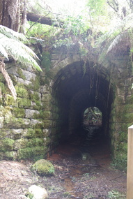
Photograph - Colour, Clare Gervasoni, Big Culvert Near Marysville, 2015, 04/11/2015
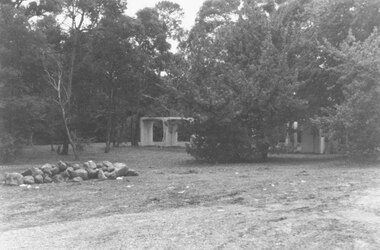
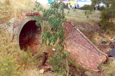
... Big Culvert Near Marysville, 2015...Colour photograph of the Big Culvert near Marysville after the "Black Saturday' Bushfire....Big Culvert Near Marysville, 2015 Photograph - Colour Clare Gervasoni ...Colour photograph of the Big Culvert near Marysville after the "Black Saturday' Bushfire.bushfire, black saturday, marysville, regrowth -
Glenelg Shire Council Cultural Collection
Photograph - Photograph - Cape Grant Quarry, 27/08/1953
... Black and white photo of Cape Grant quarry road culvert, looking south-west....Glenelg Shire Council Cultural Collection History House Cliff Street Portland great-ocean-road Port of Portland Authority Archives Back: Purple PHT stamp Black and white photo of Cape Grant quarry road culvert, looking south-west. Photograph Photograph - Cape Grant Quarry ...Port of Portland Authority ArchivesBack: Purple PHT stamp -
Glenelg Shire Council Cultural Collection
Photograph - Photograph - Cape Grant Quarry, 03/07/1953
... Black and white photo of culvert on Cape Grant quarry road. Lawrence Rocks in background...Glenelg Shire Council Cultural Collection History House Cliff Street Portland great-ocean-road Port of Portland Authority Archives Port of Portland Archives Cape Grant Quarry Back: Purple PHT stamp Black and white photo of culvert on Cape Grant quarry road. Lawrence Rocks in background Photograph Photograph - Cape Grant Quarry ...Port of Portland Authority ArchivesBack: Purple PHT stampport of portland archives, cape grant quarry -
Glenelg Shire Council Cultural Collection
Photograph - Photograph - Cape Grant Quarry, Portland, n.d
... Black and white photo, Cape Grant Quarry road culvert, looking north east....Glenelg Shire Council Cultural Collection History House Cliff Street Portland great-ocean-road Port of Portland Authority Archives Port of Portland Archives Cape Grant Quarry Portland Harbour construction Front: Back- Purple PHT stamp Black and white photo, Cape Grant Quarry road culvert, looking north east. Photograph Photograph - Cape Grant Quarry, Portland ...Port of Portland Authority ArchivesFront: Back- Purple PHT stampport of portland archives, cape grant quarry, portland harbour, construction -
 Ringwood and District Historical Society
Photograph, Warrandyte Rd. culvert upstream (East) side. Ringwood 1987
... Warrandyte Rd. culvert upstream (East) side. Ringwood 1987...Written on back of photograph, "13.4.87. Warrandyte Rd. culvert upstream (East) side."...Ringwood and District Historical Society 125A Warrandyte Road Ringwood North melbourne Written on back of photograph, "13.4.87. Warrandyte Rd. culvert upstream (East) side." Warrandyte Rd. culvert upstream (East) side. ...Written on back of photograph, "13.4.87. Warrandyte Rd. culvert upstream (East) side." -
Glenelg Shire Council Cultural Collection
Photograph - Photograph - Soil Erosion Casterton, n.d
... Man standing near culvert under road, shows erosion of banks...Man standing near culvert under road, shows erosion of banks Photograph Photograph - Soil Erosion Casterton J.T. ...Sourced from Casterton Town Hall (Former Shire of Glenelg))Black and white photo. Man standing near culvert under road, shows erosion of banksBack: Round, purple, photographer's stamp -
Glenelg Shire Council Cultural Collection
Plan - Plan - Country Roads Board Specifications, n.d
... Black and white photographic copy of Country Roads Board specifications for concrete end walls for pipe culverts...Glenelg Shire Council Cultural Collection History House Cliff Street Portland great-ocean-road Port of Portland Authority Archives Port of Portland Archives Black and white photographic copy of Country Roads Board specifications for concrete end walls for pipe culverts Plan Plan - Country Roads Board Specifications ...Port of Portland Authority Archivesport of portland archives -
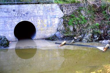
 Eltham District Historical Society Inc
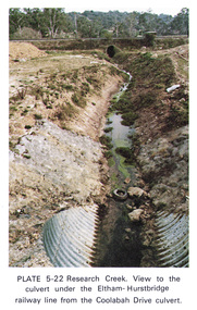
Work on paper (Sub-Item) - Photograph, Research Creek. View to the culvert under the Eltham-Hurstbridge railway line from the Coolabah Drive culvert
... Research Creek. View to the culvert under the Eltham-Hurstbridge railway line from the Coolabah Drive culvert......culvert...Colour photograph of Research Creek. View to the culvert under the Eltham-Hurstbridge railway line from the Coolabah Drive culvert, Eltham...View to the culvert under the Eltham-Hurstbridge railway line from the Coolabah Drive culvert Work on paper Photograph ...Colour photograph of Research Creek. View to the culvert under the Eltham-Hurstbridge railway line from the Coolabah Drive culvert, Elthameltham, research creek, coolabah drive, culvert, eltham hurstbridge railway, drain -
 Bendigo Historical Society Inc.
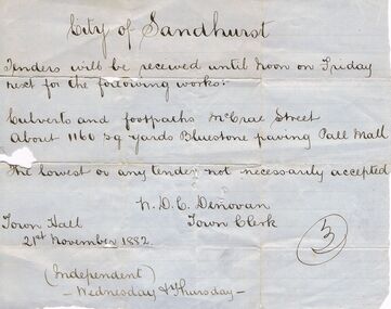
Document - TENDER DOCUMENT: CULVERTS AND FOOTPATHS, 1882, 21/11/1882
... Handwritten tender document - culverts and footpaths, 21st Nov 1882. Work for McCrae St and paving of Pall Mall. ...Document TENDER DOCUMENT: CULVERTS AND FOOTPATHS, 1882 ...Handwritten tender document - culverts and footpaths, 21st Nov 1882. Work for McCrae St and paving of Pall Mall. Issued by N Denovan, Town Clerk - Notice for the ''Independent''.N. Denovanbendigo, council, city of sandhurst, mccrae street, pall mall. h. d. c. denovan -
 Greensborough Historical Society
Slide - Photograph, John Ramsdale, Drain into Plenty River: Slide 8, 1990s
... Photograph shows a drain or culvert near the Plenty River....Greensborough Historical Society 34A Glenauburn Road Lower Plenty Lower Plenty melbourne Photograph shows a drain or culvert near the Plenty River. Part of the John Ramsdale collection of slides and audio visual material. plenty river drains pollution No maker's marks. ...Photograph shows a drain or culvert near the Plenty River.Part of the John Ramsdale collection of slides and audio visual material.Colour photograph scanned from slide.No maker's marks. No caption on slide.plenty river, drains, pollution -
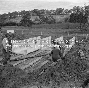 Eltham District Historical Society Inc
Negative - Photograph, J.A. McDonald, Hurstbridge-Arthurs Creek Road, Aug. 1960
... Laying culverts on boards A. Gillies, F. Wood, G. Blair...Eltham District Historical Society Inc 728 Main Rd Eltham melbourne Laying culverts on boards A. Gillies, F. Wood, G. Blair Record of various Shire of Eltham infrastructure works undertaken during the period of 1952-1962 involving bridge and road reconstruction projects, sometimes with Eltham Shire Council Project Reference numbers quoted. ...Laying culverts on boards A. Gillies, F. Wood, G. BlairRecord of various Shire of Eltham infrastructure works undertaken during the period of 1952-1962 involving bridge and road reconstruction projects, sometimes with Eltham Shire Council Project Reference numbers quoted. It was during this period that a number of significant improvements were made to roads and new bridges constructed within the shire that remain in place as of present day (2022). In many situations, the photos provide a tangible visible record of infrastructure that existed throughout the early days of the Shire. The album was put together by or under the direction of the Shire Engineer, J.A. McDonald.infrastructure, shire of eltham, 1960-08, a. gillies, f. wood, g. blair, hurstbridge-arthurs creek road, bridge construction, road construction