Showing 27 items matching "dalhousie"
-
 Glenelg Shire Council Cultural Collection
Book, The Panmure Papers. Vol: II, 1908
... The Panmure Papers being a selection from the correspondence of Fox Maule, second Baron Panmure, afterwards eleventh Earl of Dalhousie, K.T., G.C.B. vol II, Hodder & Stoughton, 1908....Douglas, Sir George (Bart., MA) & Ramsay, Sir George Dalhousie (C.B.) [eds]...Vol: II Book Book Douglas, Sir George (Bart., MA) & Ramsay, Sir George Dalhousie (C.B.) [eds] ...The Panmure Papers being a selection from the correspondence of Fox Maule, second Baron Panmure, afterwards eleventh Earl of Dalhousie, K.T., G.C.B. vol II, Hodder & Stoughton, 1908.Maroon cloth-covered spine and cardboard covers. Graphics and text in gold on spine and front cover.The Panmure Papers being a selection from the correspondence of Fox Maule, second Baron Panmure, afterwards eleventh Earl of Dalhousie, K.T., G.C.B. vol II, Hodder & Stoughton, 1908.history, military history, crimean war, florence nightingale -
 Glenelg Shire Council Cultural Collection
Book, The Panmure Papers. Vol: I, 1908
... Douglas, Sir George (Bart., MA) & Ramsay, Sir George Dalhousie (C.B.) [eds]...Vol: I Book Book Douglas, Sir George (Bart., MA) & Ramsay, Sir George Dalhousie (C.B.) [eds] ...Correspondence of Fox Maule, Second Baron Panmure, Afterwards Eleventh Earl of Dalhousie,Maroon cloth-covered spine and cardboard covers. Graphics and text in gold on spine and front cover.Correspondence of Fox Maule, Second Baron Panmure, Afterwards Eleventh Earl of Dalhousie,crimean war, history, war history, military -
 Bendigo Historical Society Inc.
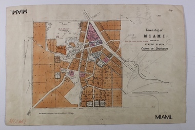
Map - MIAMI ( MIA MIA), 26/06/1906
... ...Dalhousie...Map: Township of Miami (Mia Mia), Parish of Spring Plains, County of Dalhousie...History House 11 Mackenzie Street Bendigo goldfields The name Miami on the is a misprint MAP Dalhousie township Mia Mia Spring Plains Creek Map: Township of Miami (Mia Mia), Parish of Spring Plains, County of Dalhousie Map MIAMI ( MIA MIA) ...The name Miami on the is a misprint Map: Township of Miami (Mia Mia), Parish of Spring Plains, County of Dalhousiemap, dalhousie, township, mia mia, spring plains creek -
 Bendigo Historical Society Inc.
Map - HEATHCOTE, 11/04/1935
... ...Dalhousie...Map: Parish of Heathcote, County of Dalhousie. Parish plan (number 320 in map cupboard 1)...History House 11 Mackenzie Street Bendigo goldfields MAP Dalhousie parish plan Heathcote Map: Parish of Heathcote, County of Dalhousie. ...Map: Parish of Heathcote, County of Dalhousie. Parish plan (number 320 in map cupboard 1)map, dalhousie, parish plan, heathcote -
Bendigo Historical Society Inc.
Map - LANGWORNOR, 17/07/1942
... ...Dalhousie...Map: Langwornor, County of Dalhousie. Parish Plan, coloured ( number 165 in Map Cupboard 1)...History House 11 Mackenzie Street Bendigo goldfields MAP Dalhousie parish plan Langwornor County of Dalhousie Map: Langwornor, County of Dalhousie. ...Map: Langwornor, County of Dalhousie. Parish Plan, coloured ( number 165 in Map Cupboard 1)map, dalhousie, parish plan, langwornor, county of dalhousie -
Bendigo Historical Society Inc.
Map - COSTERFIELD, 2/09/1939
... ...Dalhousie...Map: Costerfield, Counties of Dalhousie and Rodney. Parish plan ( number 163 in Map Cupboard 1)...History House 11 Mackenzie Street Bendigo goldfields MAP Dalhousie parish plan Costerfield Counties of Dalhousie and Rodney Map: Costerfield, Counties of Dalhousie and Rodney. ...Map: Costerfield, Counties of Dalhousie and Rodney. Parish plan ( number 163 in Map Cupboard 1)map, dalhousie, parish plan, costerfield, counties of dalhousie and rodney -
Bendigo Historical Society Inc.
Map - LANGWORNOR SHEET 2, 26/06/1889
... ...Dalhousie...Map: Langwornor sheet 2, County of Dalhousie. Parish plan ( number 173 in Map Cupboard 1)...History House 11 Mackenzie Street Bendigo goldfields MAP Dalhousie parish plan Langwornor County of Dalhousie Map: Langwornor sheet 2, County of Dalhousie. ...Map: Langwornor sheet 2, County of Dalhousie. Parish plan ( number 173 in Map Cupboard 1)map, dalhousie, parish plan, langwornor, county of dalhousie -
Bendigo Historical Society Inc.
Map - LANGWORNOR SHEET 1, No date visible
... ...Dalhousie...Map: Langwornor sheet 1, County of Dalhousie. Parish plan ( number 174 in Map Cupboard 1)...History House 11 Mackenzie Street Bendigo goldfields MAP Dalhousie parish plan Langwornor County of Dalhousie Map: Langwornor sheet 1, County of Dalhousie. ...Map: Langwornor sheet 1, County of Dalhousie. Parish plan ( number 174 in Map Cupboard 1)map, dalhousie, parish plan, langwornor, county of dalhousie -
Bendigo Historical Society Inc.
Map - TOWNSHIP OF HEATHCOTE (PART), 11/04/1935
... ...Dalhousie...Map: Township of Heathcote (part), Parish of Heathcote, County of Dalhousie. Parish plan (number 259 in map cupboard 1)...History House 11 Mackenzie Street Bendigo goldfields MAP Dalhousie township Heathcote Copunty of Dalhousie Map: Township of Heathcote (part), Parish of Heathcote, County of Dalhousie. ...Map: Township of Heathcote (part), Parish of Heathcote, County of Dalhousie. Parish plan (number 259 in map cupboard 1)map, dalhousie, township, heathcote, copunty of dalhousie -
Bendigo Historical Society Inc.
Map - TOWNSHIP OF HEAHCOTE SHEET 1, 29/07/1935
... ...Dalhousie...Map: Township of Heathcote sheet 1, parish of Heathcote, County of Dalhousie. Parish plan (number 253 in map cupboard 1)...History House 11 Mackenzie Street Bendigo goldfields MAP Dalhousie township Heathcote Conty of Dalhousie Map: Township of Heathcote sheet 1, parish of Heathcote, County of Dalhousie. ...Map: Township of Heathcote sheet 1, parish of Heathcote, County of Dalhousie. Parish plan (number 253 in map cupboard 1)map, dalhousie, township, heathcote, conty of dalhousie -
 Bendigo Historical Society Inc.
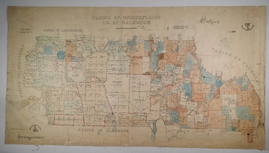
Map - SPRING PLAINS, Examined 31/01/1876
... ...Dalhousie...Map: Parish of Springplains, County of Dalhousie. Parish plan June 1874 A.D. Scott Examined E.D. 4.7.74 Additions made March 1877 Written in blue " See new plan."...History House 11 Mackenzie Street Bendigo goldfields MAP Dalhousie parish plan Spring Plains A. D. Scott Map: Parish of Springplains, County of Dalhousie. ...Map: Parish of Springplains, County of Dalhousie. Parish plan June 1874 A.D. Scott Examined E.D. 4.7.74 Additions made March 1877 Written in blue " See new plan."map, dalhousie, parish plan, spring plains, a. d. scott -
 Bendigo Historical Society Inc.
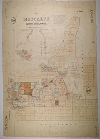
Map - METCALFE, 30/10/1878
... ...Dalhousie...Map: Metcalfe, County of Dalhousie. Parish plan (also has a smaller addition glued onto the right hand side) F. ...History House 11 Mackenzie Street Bendigo goldfields MAP Dalhousie parish plan Metcalfe F. J. Vincent Map: Metcalfe, County of Dalhousie. ...Map: Metcalfe, County of Dalhousie. Parish plan (also has a smaller addition glued onto the right hand side) F. J. Vincent Draftsman Oct. 1876 Ex (unreadable signature) Oct 1878map, dalhousie, parish plan, metcalfe, f. j. vincent -
Bendigo Historical Society Inc.
Map - REDESDALE, See above
... ...Dalhousie...Map: two maps on either side of backing, (1) Township of Redesdale, Parish of Redesdale. (2) Surban lands, Parish of Spring Plains, County of Dalhousie. Date are 26th May 1873 and 12/07/1909 ( number 157 in Map Cupboard 1)...History House 11 Mackenzie Street Bendigo goldfields MAP Dalhousie township Redesdale Parish of Spring Plains County of Dalhousie Map: two maps on either side of backing, (1) Township of Redesdale, Parish of Redesdale. (2) Surban lands, Parish of Spring Plains, County of Dalhousie. ...Map: two maps on either side of backing, (1) Township of Redesdale, Parish of Redesdale. (2) Surban lands, Parish of Spring Plains, County of Dalhousie. Date are 26th May 1873 and 12/07/1909 ( number 157 in Map Cupboard 1)map, dalhousie, township, redesdale, parish of spring plains, county of dalhousie -
Bendigo Historical Society Inc.
Map - COSTERFIELD : COUNTY OF BENDIGO, 29-10-29
... Costerfield, County of Bendigo, Counties of Dalhousie & Rodney, Dargile, Moormbool West, Warrowitue, Heathcote, Town of Costerfield, Dalhousie. ...Costerfield, County of Bendigo, Counties of Dalhousie & Rodney, Dargile, Moormbool West, Warrowitue, Heathcote, Town of Costerfield, Dalhousie. ...Map. Costerfield, County of Bendigo, Counties of Dalhousie & Rodney, Dargile, Moormbool West, Warrowitue, Heathcote, Town of Costerfield, Dalhousie. By Authority H.J. Green, Government Printer, Melbourne. Drawn and reproduced at the Department of Lands and Survey, Melbourne. 29-10-29. Price 2/-. (number 92 in map cupboard 1)H.J. Green, Government Printer, Melbourne.map, bendigo, costerfield -
 Bendigo Historical Society Inc.
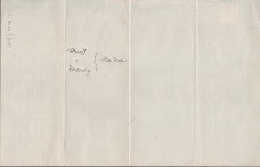
Legal record - FEATONBY Mrs Anne - Sale Note, Watson, James & Rogers, Rogers Collection, 10.02.1920
... FEATONBY, Mrs Anne Sale note re Crown Allotment 4, Parish of Warriwitue County of Dalhousie. Cream coloured paper....FEATONBY, Mrs Anne Sale note re Crown Allotment 4, Parish of Warriwitue County of Dalhousie. Cream coloured paper. Rogers Collection Legal record FEATONBY Mrs Anne - Sale Note Watson, James & Rogers ...In the early 1980s the firm of Watson, James & Rogers merged with the partnership of Every & Every and became the iconic “Rogers & Every” as known today. The firm is still located on Bull Street. https://rogersevery.com.au/about/FEATONBY, Mrs Anne Sale note re Crown Allotment 4, Parish of Warriwitue County of Dalhousie. Cream coloured paper.Signatures.sale note, sherriff, featonby, public auction, land sale, nicholas kennedy -
Bendigo Historical Society Inc.
Map - COSTERFIELD : COUNTY OF BENDIGO, 31-10-12
... Costerfield, County of Bendigo, County of Dalhousie, Dargile, Moorambool West, Warrowitue, Heathcote, Town of Costerfield. ...Costerfield, County of Bendigo, County of Dalhousie, Dargile, Moorambool West, Warrowitue, Heathcote, Town of Costerfield. ...Map. Costerfield, County of Bendigo, County of Dalhousie, Dargile, Moorambool West, Warrowitue, Heathcote, Town of Costerfield. Photo-Lithographed at the Department of Lands and Survey, Melbourne, by W.J .Butson 31-10-12 price 1/-. (number 93 in map cupboard 1)W.J. Butsonmap, bendigo, costerfield -
Bendigo Historical Society Inc.
Map - HEATHCOTE : COUNTY OF BENDIGO, 19-2-1942
... Heathcote, County of Bendigo. County of Dalhousie, McIvor Creek,Wallan and Bendigo Railway, By authority H.E. ...Heathcote, County of Bendigo. County of Dalhousie, McIvor Creek,Wallan and Bendigo Railway, By authority H.E. ...Map. Heathcote, County of Bendigo. County of Dalhousie, McIvor Creek,Wallan and Bendigo Railway, By authority H.E. Daw, Government Printer, Melbourne. Drawn and reproduced at the Department of Lands and Survey, Melbourne. 19-2-1942. Price 2/-. (number 90 in map cupboard 1)H.E. Daw, Government Printer, Melbourne.map, bendigo, heathcote -
 Bacchus Marsh & District Historical Society
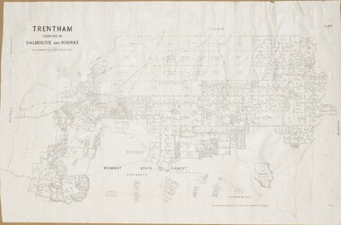
Map, Trentham Parish Map 1905 Copy 1
... A single page paper map showing the map for the Parish of Trentham in the Counties of Dalhousie and Bourke. A cadastral map showing parish boundaries and land ownership. ...McGauran 22.3.05 A single page paper map showing the map for the Parish of Trentham in the Counties of Dalhousie and Bourke. A cadastral map showing parish boundaries and land ownership. ...A single page paper map showing the map for the Parish of Trentham in the Counties of Dalhousie and Bourke. A cadastral map showing parish boundaries and land ownership. The map is pasted into a bound volume containing 76 maps or plans in total. High resolution digital image stored on BMDHS computer network. Photo-lithographed at the Department of Lands and Survey, Melbourne by T.F. McGauran 22.3.05 trentham parish maps, trentham parish plan, bacchus marsh region parish plans -
Bendigo Historical Society Inc.
Map - TOWNSHIP OF HEATHCOTE SHEET 2, Circa 1935
... ...Dalhousie...History House 11 Mackenzie Street Bendigo goldfields MAP Dalhousie township Heathcote Map: Township of Heathcote sheet 2. ...Map: Township of Heathcote sheet 2. Parish plan (number 254 in map cupboard 1)map, dalhousie, township, heathcote -
Bendigo Historical Society Inc.
Map - HEATHCOTE : COUNTY OF BENDIGO, 11-4-35
... Heathcote, County of Bendigo, County of Dalhousie,Township of Heathcote, McIvor Creek, Argyle Station Ground, Wallan and Bendigo Railway, C.R.B. ...Heathcote, County of Bendigo, County of Dalhousie,Township of Heathcote, McIvor Creek, Argyle Station Ground, Wallan and Bendigo Railway, C.R.B. ...Map. Heathcote, County of Bendigo, County of Dalhousie,Township of Heathcote, McIvor Creek, Argyle Station Ground, Wallan and Bendigo Railway, C.R.B. Main Road. By authority H.J. Green, Govt. Printer. Photo-Lithographed at the Department of Lands and Survey, Melbourne. 11-4-35. Price 2/-. (number 88 in map cupboard 1)H.J. Green, Govt.Printermap, bendigo, heathcote -
Bendigo Historical Society Inc.
Map - REDESDALE : COUNTY OF BENDIGO, 24-12-24
... Redesdale, County of Bendigo, County of Dalhousie, Kimbolton, Langwornor, Spring Plains, Glenhope, Emberton, Metcalfe, Hawkestone, County of Talbot, Campaspe River, Back Creek, River Coliban, Lyell. ...Redesdale, County of Bendigo, County of Dalhousie, Kimbolton, Langwornor, Spring Plains, Glenhope, Emberton, Metcalfe, Hawkestone, County of Talbot, Campaspe River, Back Creek, River Coliban, Lyell. ...Map. Redesdale, County of Bendigo, County of Dalhousie, Kimbolton, Langwornor, Spring Plains, Glenhope, Emberton, Metcalfe, Hawkestone, County of Talbot, Campaspe River, Back Creek, River Coliban, Lyell. By authority H.J. Green, Government Printer, Melbourne. Photo-Lithographed at the Department of Lands and Survey, Melbourne by W.J. Butson, 24-12-24, Price 1/-. (number 120 in map cupboard 1)H.J. Green, Government Printer, Melbourne.map, bendigo, redesdale -
Bendigo Historical Society Inc.
Map - HEATHCOTE : COUNTY OF BENDIGO
... Heathcote, County of Bendigo, County of Dalhousie, Knowsley, Knowsley East, Dargile, Costerfield, Warrowitue, Tooborac, Langwornor, Argyle Station Ground, Bendigo to Heathcote to Kilmore Railway Line, Township of Heathcote, C.R.B. ...Heathcote, County of Bendigo, County of Dalhousie, Knowsley, Knowsley East, Dargile, Costerfield, Warrowitue, Tooborac, Langwornor, Argyle Station Ground, Bendigo to Heathcote to Kilmore Railway Line, Township of Heathcote, C.R.B. ...Map. Heathcote, County of Bendigo, County of Dalhousie, Knowsley, Knowsley East, Dargile, Costerfield, Warrowitue, Tooborac, Langwornor, Argyle Station Ground, Bendigo to Heathcote to Kilmore Railway Line, Township of Heathcote, C.R.B. Main Road. Mount Ida Creek, Wild Duck Creek, Meadow Valley Creek. By Authority H.J. Green, Govt. Printer, Photo-Lithographed at the Department of Lands and Survey, Melbourne by W.J. Butson, Price 1/-. (number 91 in map cupboard 1)H.J. Green Govt. Printer.map, bendigo, heathcote -
Bendigo Historical Society Inc.
Map - REDESDALE : COUNTY OF BENDIGO, 25 -10-77
... Redesdale, County of Bendigo, County of Dalhousie, County Of Talbot, Lyell, Kimbolton, Langwornor, Spring Plains, Glenhope, Emberton, Metcalfe, Hawkestone, River Coliban, Campaspe River, Back Creek. ...Redesdale, County of Bendigo, County of Dalhousie, County Of Talbot, Lyell, Kimbolton, Langwornor, Spring Plains, Glenhope, Emberton, Metcalfe, Hawkestone, River Coliban, Campaspe River, Back Creek. ...Map. Redesdale, County of Bendigo, County of Dalhousie, County Of Talbot, Lyell, Kimbolton, Langwornor, Spring Plains, Glenhope, Emberton, Metcalfe, Hawkestone, River Coliban, Campaspe River, Back Creek. Photo-Lithographed at the Department of Lands and Survey, Melbourne by J. Noune, 25-10-77. Compared with original plans 12-11-78 M. Kemp. J.C.Kelsh, Draughtsman April 1876. Examined by E. Downward, 5-6-77. (number 121 in map cupboard 1)J. Nounemap, bendigo, redesdale -
 Bendigo Historical Society Inc.
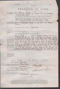
Document - CONNELLY, TATCHELL, DUNLOP COLLECTION: SIMMS TO LUXTON & CARTER
... Luxton and Carter, portions 306 and 307 Parish of Lauriston, County of Dalhousie dated 10th. March, 1888. Conditions of Sale ( blue document ) between Thomas Luxton to Samuel Simms ( C. ...Luxton and Carter, portions 306 and 307 Parish of Lauriston, County of Dalhousie dated 10th. March, 1888. Conditions of Sale ( blue document ) between Thomas Luxton to Samuel Simms ( C. ...Documents enclosed in red ribbon relating to mortgages between Samuel Simms and Messrs. Luxton and Carter, portions 306 and 307 Parish of Lauriston, County of Dalhousie dated 10th. March, 1888. Conditions of Sale ( blue document ) between Thomas Luxton to Samuel Simms ( C. Yeo and Sons as agents for the vendor ). Agreement between Mrs. Annie Turner Chappel, of Pine Grove, with Messrs. A.H. Sims and C.W. Sims. ( F.N.H. Atkyns, Barrister & Solicitor, High Street, Echuca, 1906 ) and Transfer of Land document, between Thomas Luxton of Kangaroo Flat to Samuel Sims of Pine Grove, near Mitiamo.organisation, union, connelly, tatchell & dunlop, annie turner chappel, a.h. sims, c.w., sims. f.n.h. atkyns, thomas luxton, jabez carter, pine grove, mitiamo -
Bendigo Historical Society Inc.
Map - BENDIGO, 1916
... Bendigo, Gunbower, Gladstone, Talbot, Dalhousie, Rodney, Jarklan, Calivil, Hayanmi, Mitiamo, Wanurp, Pannoobamawm, Bamawm, Millewa, Ballendella, Janiember West, Janiember East, Pompapiel, Talambe, Dingee, Milloo, Pannoomilloo, Rochester West, Yarrayne, Salisbury, Yallook, Tandarra, Kamarooka, Warragamba, Diggorra, Minto, Bridgewater, Yarraberb, Neilborough, Whirrakee, Egerton, Elmore, Nolan, Goornong, Bagshot, Huntly, Derby, Leichardt, Nerring, Tarnagulla, Woodstock, Marong, Sandhurst, Wellsford, Bendigo, Axedale, Strathfieldsaye, Eppalock, Kimbolton, Lyell, Sedgwick, Mandurang, Lockwood, Ravenswood, Shelbourne, Laanecoorie. ...Bendigo, Gunbower, Gladstone, Talbot, Dalhousie, Rodney, Jarklan, Calivil, Hayanmi, Mitiamo, Wanurp, Pannoobamawm, Bamawm, Millewa, Ballendella, Janiember West, Janiember East, Pompapiel, Talambe, Dingee, Milloo, Pannoomilloo, Rochester West, Yarrayne, Salisbury, Yallook, Tandarra, Kamarooka, Warragamba, Diggorra, Minto, Bridgewater, Yarraberb, Neilborough, Whirrakee, Egerton, Elmore, Nolan, Goornong, Bagshot, Huntly, Derby, Leichardt, Nerring, Tarnagulla, Woodstock, Marong, Sandhurst, Wellsford, Bendigo, Axedale, Strathfieldsaye, Eppalock, Kimbolton, Lyell, Sedgwick, Mandurang, Lockwood, Ravenswood, Shelbourne, Laanecoorie. ...Map. Bendigo, Gunbower, Gladstone, Talbot, Dalhousie, Rodney, Jarklan, Calivil, Hayanmi, Mitiamo, Wanurp, Pannoobamawm, Bamawm, Millewa, Ballendella, Janiember West, Janiember East, Pompapiel, Talambe, Dingee, Milloo, Pannoomilloo, Rochester West, Yarrayne, Salisbury, Yallook, Tandarra, Kamarooka, Warragamba, Diggorra, Minto, Bridgewater, Yarraberb, Neilborough, Whirrakee, Egerton, Elmore, Nolan, Goornong, Bagshot, Huntly, Derby, Leichardt, Nerring, Tarnagulla, Woodstock, Marong, Sandhurst, Wellsford, Bendigo, Axedale, Strathfieldsaye, Eppalock, Kimbolton, Lyell, Sedgwick, Mandurang, Lockwood, Ravenswood, Shelbourne, Laanecoorie. Price 3/-. Smaller map of State of Victoria. Lithographed at the Department of Lands and Survey, Melbourne. 1916. Scale : Two miles to one inch. Map was in book form. (number 62 in map cupboard 1)map, bendigo, bendigo -
 Whitehorse Historical Society Inc.
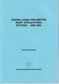
Administrative record - Crown Land Valuations and Applications, Government Printer - John FERRES, Crown Lands Pre-emptive Right Applications: Victoria 1850-1854, 1855
... ...Dalhousie...Applications relate to early settlement in the 1850's in Victoria CLARKE Andrew Anglesey Evelyn Bourke Dalhousie Dundas Follett Grant Hampden Heytesbury Normanby Polwarth Ripon Talbot Villiers District of Murray District of Wimmera District of Western Port Early Settlement Mornington Contains a valuation for Crown Lands applications under pre-emptive right by Victorian county, giving names of applicants name of run, area, and remarks. ...Contains a valuation for Crown Lands applications under pre-emptive right by Victorian county, giving names of applicants name of run, area, and remarks.Contains a valuation for Crown Lands applications under pre-emptive right by Victorian county, giving names of applicants name of run, area, and remarks. Contains a valuation for Crown Lands applications under pre-emptive right by Victorian county, giving names of applicants name of run, area, and remarks. clarke andrew, anglesey, evelyn, bourke, dalhousie, dundas, follett, grant, hampden, heytesbury, normanby, polwarth, ripon, talbot, villiers, district of murray, district of wimmera, district of western port, early settlement, mornington -
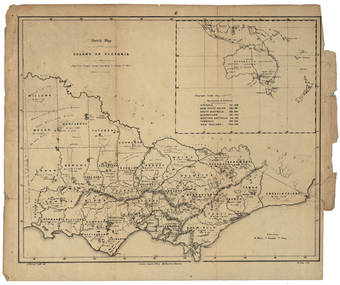 Federation University Historical Collection
Map, Robert Brough Smyth, Sketch Map of the Colony of Victoria, c1871, c1872
... ...dalhousie...Barker Library (top floor) Mount Helen goldfields victoria victorian counties robert brough-smyth telegraph population bourke rodney dalhousie evelyn mornington buln-buln tanjil dargo delatite moira bogong bendigo gunbower grant talbot hampden heytesbury polwarth ripon kara-kara gladstone grenville croajingolong tambo benambra This map includes the population of each County in Victoria according to the 1871 Census, as well as the population of each Australian colony and New Zealand. ...This map includes the population of each County in Victoria according to the 1871 Census, as well as the population of each Australian colony and New Zealand. Telegraph Route is given in a detail at the top right. victoria, victorian counties, robert brough-smyth, telegraph, population, bourke, rodney, dalhousie, evelyn, mornington, buln-buln, tanjil, dargo, delatite, moira, bogong, bendigo, gunbower, grant, talbot, hampden, heytesbury, polwarth, ripon, kara-kara, gladstone, grenville, croajingolong, tambo, benambra