Showing 2523 items matching "damaged"
-
 Linton and District Historical Society Inc
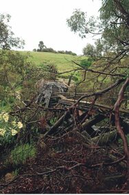
Photograph, Damaged bridge over Springdallah Creek, Happy Valley/Piggoreet, 2010
... Damaged bridge over Springdallah Creek, Happy Valley/Piggoreet, 2010...Already in a dilapidated condition, this bridge was further damaged by floodwaters in 2010 and 2011. In 2025, little remains of the old bridge....Colour photograph showing damage to a trestle bridge spanning Springdallah Creek, Linton-Piggoreet Road....Damaged bridge over Springdallah Creek, Happy Valley/Piggoreet, 2010 Photograph ...Already in a dilapidated condition, this bridge was further damaged by floodwaters in 2010 and 2011. In 2025, little remains of the old bridge.Colour photograph showing damage to a trestle bridge spanning Springdallah Creek, Linton-Piggoreet Road.Text, handwritten reverse: 'WE CLIMBED THE HILL / TO PHOTOGRAPH THE / BRIDGE AT EYE LEVEL. / YOU CAN SEE THE / PLANKS (AND WHERE THOSE / MISSING) AND THE / SIDE RAILS.trestle bridges, old springdallah bridge -
![Photograph - Digital Image, Grave of William Poulter and Mary Chapman Poulter, Greensborough Cemetery [damaged headstone and replacement headstone], 13/03/1888](/media/collectors/4f729f5697f83e03086015b8/items/54c5d0a42162f1173053178c/item-media/54c5d14e2162f11730532268/item-fit-380x285.jpg?cb=6) Greensborough Historical Society
Greensborough Historical SocietyPhotograph - Digital Image, Grave of William Poulter and Mary Chapman Poulter, Greensborough Cemetery [damaged headstone and replacement headstone], 13/03/1888
... Grave of William Poulter and Mary Chapman Poulter, Greensborough Cemetery [damaged headstone and replacement headstone]...Grave of William Poulter (died 13/03/1888) and Mary Chapman Poulter (died 18/09/1899) [date not clear due to damage] in Plot#B8 Greensborough Cemetery. Photographs 2 and 3 shows the replacement headstone erected circa 2012....Digital copy of colour photograph of damaged grave/headstone. Digital copy of colour photographs of replacement headstone....Post 2012 descendants of some pioneer families have been replacing damaged headstones. william poulter mary chapman poulter greensborough cemetery Digital copy of colour photograph of damaged grave/headstone. ...Grave of William Poulter (died 13/03/1888) and Mary Chapman Poulter (died 18/09/1899) [date not clear due to damage] in Plot#B8 Greensborough Cemetery. Photographs 2 and 3 shows the replacement headstone erected circa 2012.Greensborough Cemetery was created when land was given for the cemetery by Mr William Poulter, a local settler, about 1864. The cemetery holds the graves of many early settlers in the district. Post 2012 descendants of some pioneer families have been replacing damaged headstones.Digital copy of colour photograph of damaged grave/headstone. Digital copy of colour photographs of replacement headstone.william poulter, mary chapman poulter, greensborough cemetery -
 National Vietnam Veterans Museum (NVVM)
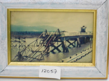
Photograph, Damaged Bridge
... Damaged Bridge....Framed coloured photo of a damaged bridge...National Vietnam Veterans Museum (NVVM) 25 Veterans Drive Newhaven phillip-island-and-the-bass-coast Photograph Bridge Framed coloured photo of a damaged bridge Damaged Bridge. Photograph Photograph ...Framed coloured photo of a damaged bridgephotograph, bridge -
![Photograph - Digital Image, Grave of William Poulter and Mary Chapman Poulter, Greensborough Cemetery [damaged headstone], 13/03/1888](/media/collectors/4f729f5697f83e03086015b8/items/54c35d872162f11550dd0b52/item-media/54c35db52162f11550dd0e01/item-fit-380x285.jpg?cb=6) Greensborough Historical Society
Greensborough Historical SocietyPhotograph - Digital Image, Grave of William Poulter and Mary Chapman Poulter, Greensborough Cemetery [damaged headstone], 13/03/1888
... Grave of William Poulter and Mary Chapman Poulter, Greensborough Cemetery [damaged headstone]...Digital copy of colour photograph of grave/headstone [damaged]...The cemetery holds approximately 250 grave sites with 350 people buried there. william poulter mary poulter mary chapman poulter greensborough cemetery Digital copy of colour photograph of grave/headstone [damaged] Grave of William Poulter and Mary Chapman Poulter, Greensborough Cemetery [damaged headstone] Photograph - Digital Image ...Grave of William Poulter (died 13/03/1888) and Mary Chapman Poulter (died 18/09/1899) in Plot#B8 Greensborough Cemetery. Greensborough Cemetery was created when land was given for the cemetery by Mr William Poulter, a local settler, about 1864. The cemetery holds the graves of many of the early settlers in the district. The cemetery holds approximately 250 grave sites with 350 people buried there. Digital copy of colour photograph of grave/headstone [damaged]william poulter, mary poulter, mary chapman poulter, greensborough cemetery -
![Photograph - Digital Image, Grave of Thomas W Finn, Greensborough Cemetery [damaged headstone], 17/06/1938](/media/collectors/4f729f5697f83e03086015b8/items/54c5c9682162f11730528332/item-media/54c5c9a52162f117305289ac/item-fit-380x285.jpg?cb=6) Greensborough Historical Society
Greensborough Historical SocietyPhotograph - Digital Image, Grave of Thomas W Finn, Greensborough Cemetery [damaged headstone], 17/06/1938
... Grave of Thomas W Finn, Greensborough Cemetery [damaged headstone]...Digital copy of colour photograph of grave/headstone [damaged]...The cemetery holds the graves of many early settlers in the district. thomas w finn greensborough cemetery Digital copy of colour photograph of grave/headstone [damaged] Grave of Thomas W Finn, Greensborough Cemetery [damaged headstone] Photograph - Digital Image ...Grave of Thomas W. Finn (died 17/06/1938) in Plot#Q11 Greensborough Cemetery. Greensborough Cemetery was created when land was given for the cemetery by Mr William Poulter, a local settler, about 1864. The cemetery holds the graves of many early settlers in the district. Digital copy of colour photograph of grave/headstone [damaged]thomas w finn, greensborough cemetery -
![Photograph - Digital Image, Grave of John Scotland, Mary Colquhoun, Catherine Sievwright and Jessie Scotland, Greensborough Cemetery [damaged], 21/11/1888](/media/collectors/4f729f5697f83e03086015b8/items/54c5dc362162f1173053ff3d/item-media/54c5dc752162f1173054050b/item-fit-380x285.jpg?cb=6) Greensborough Historical Society
Greensborough Historical SocietyPhotograph - Digital Image, Grave of John Scotland, Mary Colquhoun, Catherine Sievwright and Jessie Scotland, Greensborough Cemetery [damaged], 21/11/1888
... Grave of John Scotland, Mary Colquhoun, Catherine Sievwright and Jessie Scotland, Greensborough Cemetery [damaged]...Digital copy of colour photograph of grave/headstone [damaged]...The cemetery holds the graves of many early settlers in the district. john scotland mary colquhoun catherine sievwright janet scotland greensborough cemetery Digital copy of colour photograph of grave/headstone [damaged] Grave of John Scotland, Mary Colquhoun, Catherine Sievwright and Jessie Scotland, Greensborough Cemetery [damaged] Photograph - Digital Image ...Grave of John Scotland (died 21/11/1888), Mary Colquhoun (died 15/02/1902), Catherine Sievwright (died 10/01/1910) and Jessie Scotland (died 21/07/1924) in Plot# M8/M9 Greensborough Cemetery. Photograph shows this monument after vandals toppled it. Greensborough Cemetery was created when land was given for the cemetery by Mr William Poulter, a local settler, about 1864. The cemetery holds the graves of many early settlers in the district. Digital copy of colour photograph of grave/headstone [damaged]john scotland, mary colquhoun, catherine sievwright, janet scotland, greensborough cemetery -
 Ballarat Tramway Museum
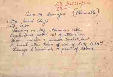
Document, State Electricity Commission of Victoria (SECV), "Tram 34 Damaged (Claimable)"
... "Tram 34 Damaged (Claimable)"...Handwritten note about accident damage to tram 34 - damage to step board, motorman's step, staunchion, broken mirror, woodwork and paint damage, and two small steps taken off. ...Ballarat Tramway Museum South Gardens Reserve Wendouree Parade Ballarat Ballarat goldfields Handwritten note about accident damage to tram 34 - damage to step board, motorman's step, staunchion, broken mirror, woodwork and paint damage, and two small steps taken off. ...Handwritten note about accident damage to tram 34 - damage to step board, motorman's step, staunchion, broken mirror, woodwork and paint damage, and two small steps taken off. It is not possible to determine the date of the accident from item 9155. Would have to work through the tram depot diaries.Yields information about an accident to tram 34.Hand written note on the back of a SEC roster sheet.In red ink "AR/74 B22010/636"secv, ballarat, accidents, tram 34 -
![Photograph - Digital Image, Grave of William Poulter and Mary Chapman Poulter, Greensborough Cemetery [damaged headstone], 13/03/1888](/media/collectors/4f729f5697f83e03086015b8/items/54c5d7782162f117305391b6/item-media/54c5d7b92162f11730539655/item-fit-380x285.jpg?cb=6) Greensborough Historical Society
Greensborough Historical SocietyPhotograph - Digital Image, Grave of William Poulter and Mary Chapman Poulter, Greensborough Cemetery [damaged headstone], 13/03/1888
... Grave of William Poulter and Mary Chapman Poulter, Greensborough Cemetery [damaged headstone]...Grave of William Poulter (died 13/03/1888) and Mary Poulter (died 18/09/1899) in Plot#B8 Greensborough Cemetery. This damaged monument was restored to its former position....Grave of William Poulter and Mary Chapman Poulter, Greensborough Cemetery [damaged headstone] Photograph - Digital Image ...Grave of William Poulter (died 13/03/1888) and Mary Poulter (died 18/09/1899) in Plot#B8 Greensborough Cemetery. This damaged monument was restored to its former position.Greensborough Cemetery was created when land was given for the cemetery by Mr William Poulter, a local settler, about 1864. The cemetery holds the graves of many early settlers in the district. Digital copy of colour photograph of grave/headstone.william poulter, mary poulter, greensborough cemetery -
 Melbourne Tram Museum
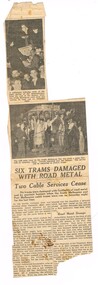
Newspaper, The Argus, "Six Trams Damaged with Road Metal", 15/03/1937 12:00:00 AM
... "Six Trams Damaged with Road Metal"...Newspaper Clipping - from The Argus Monday 15/3/1937, titled "Six Trams Damaged with Road Metal", about the damage caused at the time of the closure of the South Melbourne and Port Melbourne cable tram services - by souvenir hunters and people at the Port Melbourne depot who through road metal (stones) at the trams as they came into the depot. ...Melbourne Tram Museum 8 Wallen Road Hawthorn melbourne Trams tramways Collins St Port Melbourne South Melbourne Cable Trams Closure Buses Newspaper Clipping - from The Argus Monday 15/3/1937, titled "Six Trams Damaged with Road Metal", about the damage caused at the time of the closure of the South Melbourne and Port Melbourne cable tram services - by souvenir hunters and people at the Port Melbourne depot who through road metal (stones) at the trams as they came into the depot. ...Newspaper Clipping - from The Argus Monday 15/3/1937, titled "Six Trams Damaged with Road Metal", about the damage caused at the time of the closure of the South Melbourne and Port Melbourne cable tram services - by souvenir hunters and people at the Port Melbourne depot who through road metal (stones) at the trams as they came into the depot. The timeline gives the date of closure as Saturday 13/3/1937. Notes one of the Gripmen was a Mr. J. Armstrong. A comparison with the cutting as collected and the reproduction in The Argus on Trove, while the same photographs has a different text layout and text, possibly indicating two different editions of the paper.trams, tramways, collins st, port melbourne, south melbourne, cable trams, closure, buses -
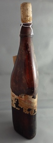 Greensborough Historical Society
Bottle, Linseed Oil bottle, 1950c
... Linseed oil bottle with damaged paper label....Brown glass bottle, triangular shape with cork stopper and damaged paper label....On damaged paper label "Raw Linseed Oil"...Greensborough Historical Society 34A Glenauburn Road Lower Plenty Lower Plenty melbourne Linseed oil bottle with damaged paper label. linseed oil On damaged paper label "Raw Linseed Oil" Brown glass bottle, triangular shape with cork stopper and damaged paper label. ...Linseed oil bottle with damaged paper label.Brown glass bottle, triangular shape with cork stopper and damaged paper label.On damaged paper label "Raw Linseed Oil"linseed oil -
 Ballarat Tramway Museum
Newspaper, The Courier Ballarat, "Green Tram's back in Bloom", "Begonia Festival Floral tram damaged by Car", Mar. 2019
... "Green Tram's back in Bloom", "Begonia Festival Floral tram damaged by Car"...Photo by Nicki Connolly. .2 - Extract from The Courier, Ballarat, website titled "Begonia Festival Floral tram damaged by Car", 11/3/2019 about the accident between a car and No. 661 on Sunday 10/3/2019. ..."Green Tram's back in Bloom", "Begonia Festival Floral tram damaged by Car" Newspaper The Courier Ballarat ...Set of two newspaper clippings about the Floral Tram No. 661 for the 2019 Begonia Festival. .1 - From the Herald Sun, Monday March 4, 2019, titled "Green Tram's back in Bloom" featuring a photo of part of the Floral tram with 3 children holding balloons or flowers. Has Pam Waugh on a step. Photo by Nicki Connolly. .2 - Extract from The Courier, Ballarat, website titled "Begonia Festival Floral tram damaged by Car", 11/3/2019 about the accident between a car and No. 661 on Sunday 10/3/2019. Includes a photo of the tram and quotes from Peter Waugh.floral tram, begonia festival, accidents, btm -
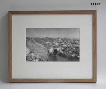 Bendigo Military Museum
Photograph - FRAMED WW1 PHOTOGRAPH, Wayne Eels, C.2008/2009
... The Grinton Collection. War damaged town or city. Refer Cat No, 1280 for Jack Grintons service details....Photograph - black and white photograph on paper, depicting a landscape of damaged and shattered buildings and rubble with a road and a vehicle in the foreground. ..."Group 2: Burden of War". "H. War Damage"....Framed accessories Camera on the Somme 38th Bn Grinton WW1 War damage "Group 2: Burden of War". "H. War Damage". ...The Grinton Collection. War damaged town or city. Refer Cat No, 1280 for Jack Grintons service details.Photograph framed. Photograph - black and white photograph on paper, depicting a landscape of damaged and shattered buildings and rubble with a road and a vehicle in the foreground. Frame - timber, light varnish finish, Perspex front, cardboard backing."Group 2: Burden of War". "H. War Damage".framed accessories, camera on the somme, 38th bn, grinton, ww1, war damage -
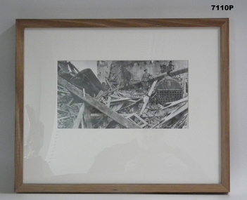 Bendigo Military Museum
Photograph - FRAMED WW1 PHOTOGRAPH, Wayne Eels, C.2008/2009
... A Soldier standing amongst Bomb damage. Refer Cat No. 1280 for Jack Grintons service details....Photograph - black and white photograph on paper, depicting a soldier and a civilian standing on a large pile of bomb damage rubble. Frame - timber, light varnish finish, Perspex front, cardboard backing...."Group 2: Burden of War". "C. Bomb Damage"....Framed accessories Camera on the Somme 38th Bn Grinton Bomb damage "Group 2: Burden of War". "C. Bomb Damage". ...The Grinton Collection. A Soldier standing amongst Bomb damage. Refer Cat No. 1280 for Jack Grintons service details.Photograph framed. Photograph - black and white photograph on paper, depicting a soldier and a civilian standing on a large pile of bomb damage rubble. Frame - timber, light varnish finish, Perspex front, cardboard backing."Group 2: Burden of War". "C. Bomb Damage".framed accessories, camera on the somme, 38th bn, grinton, bomb damage -
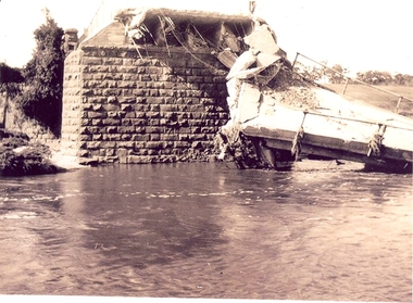 Federation University Historical Collection
Photograph - Photographs, Richard Vincent, Washed Away Bridge at Garibaldi, c1933
... Newspaper clipping documents deputations to the Minister of Public Works for grants to be made available for repairs to bridges and roads damaged by heavy flooding in 1933, in particular, the replacement of a stone and concrete bridge over the Leigh River at Garibaldi in the Buninyong Shire. ...Three black and white photographs showing flood damage to the bridge over the Leigh River at Garibaldi, plus a photocopy of a newspaper clipping from The Argus December 1933 describing the extent of the flood damage. .1) shows blue stone buttress and collapsed bridge/road. .2) mirror image of above .3) unknown man waling an a girder of the Garibaldi bridge .4) photocopy of newspaper clipping about flood damage from The Argus December 1933...Damage by Floods: Bridges washed away (The Argus December 1933)...The concrete slabs were still in the water in the 1960s/70s or even later. leigh river garibaldi buninyong shire richard vincent garibaldi bridge Damage by Floods: Bridges washed away (The Argus December 1933) Three black and white photographs showing flood damage to the bridge over the Leigh River at Garibaldi, plus a photocopy of a newspaper clipping from The Argus December 1933 describing the extent of the flood damage. .1) shows blue stone buttress and collapsed bridge/road. .2) mirror image of above .3) unknown man waling an a girder of the Garibaldi bridge .4) photocopy of newspaper clipping about flood damage from The Argus December 1933 Washed Away Bridge at Garibaldi Photograph Photographs Richard Vincent ...Newspaper clipping documents deputations to the Minister of Public Works for grants to be made available for repairs to bridges and roads damaged by heavy flooding in 1933, in particular, the replacement of a stone and concrete bridge over the Leigh River at Garibaldi in the Buninyong Shire. The concrete slabs were still in the water in the 1960s/70s or even later. Three black and white photographs showing flood damage to the bridge over the Leigh River at Garibaldi, plus a photocopy of a newspaper clipping from The Argus December 1933 describing the extent of the flood damage. .1) shows blue stone buttress and collapsed bridge/road. .2) mirror image of above .3) unknown man waling an a girder of the Garibaldi bridge .4) photocopy of newspaper clipping about flood damage from The Argus December 1933Damage by Floods: Bridges washed away (The Argus December 1933)leigh river, garibaldi, buninyong shire, richard vincent, garibaldi bridge -
 Eltham District Historical Society Inc
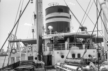
Photograph, George Coop, Fire damaged Wilhelmsen Line ship Tomar at Victoria Dock, Melbourne, Jan. 1968
... Fire damaged Wilhelmsen Line ship Tomar at Victoria Dock, Melbourne...lid=2961287 https://www.flickr.com/photos/wheelhouseno/8131145299 George Coop Collection Tomar (ship) Victoria Docks Wilhelmsen Line Digital TIFF file Scan of 35mm Kodak Plus-X Pan black and white negative transparency Fire damaged Wilhelmsen Line ship Tomar at Victoria Dock, Melbourne Photograph Photograph George Coop ...When George Coop and wife Helen following several years teaching in Canada, they bought a passage aboard the Wilhelmsen line cargo ship, Tomar departing Oslo, Norway for Melbourne, Australia. Whilst crossing the Bass Strait near Robe, South Australia, a generator in the engine room caught fire threatening the ship's fuel oil tanks, forcing the Captain to order the 43 crew and 8 passengers to abandon ship. They spent many hours in a lifeboat before being rescued. This photo was taken when the ship was brought up to Victoria Docks (No. 26 South Wharf) where George and other passengers were allowed to retrieve their luggage. The ship was then taken to Kaohsiung, Taiwan for scrapping. See also https://www.shipsnostalgia.com/media/tomar.450919/ http://www.shipspotting.com/gallery/photo.php?lid=2726028 http://www.shipspotting.com/gallery/photo.php?lid=2961287 https://www.flickr.com/photos/wheelhouseno/8131145299Digital TIFF file Scan of 35mm Kodak Plus-X Pan black and white negative transparencygeorge coop collection, tomar (ship), victoria docks, wilhelmsen line -
 Eltham District Historical Society Inc
Photograph, George Coop, Fire damaged Wilhelmsen Line ship Tomar at Victoria Dock, Melbourne, Jan. 1968
... Fire damaged Wilhelmsen Line ship Tomar at Victoria Dock, Melbourne...lid=2961287 https://www.flickr.com/photos/wheelhouseno/8131145299 George Coop Collection Tomar (ship) Victoria Docks Wilhelmsen Line Digital TIFF file Scan of 35mm Kodak Plus-X Pan black and white negative transparency Fire damaged Wilhelmsen Line ship Tomar at Victoria Dock, Melbourne Photograph Photograph George Coop ...When George Coop and wife Helen following several years teaching in Canada, they bought a passage aboard the Wilhelmsen line cargo ship, Tomar departing Oslo, Norway for Melbourne, Australia. Whilst crossing the Bass Strait near Robe, South Australia, a generator in the engine room caught fire threatening the ship's fuel oil tanks, forcing the Captain to order the 43 crew and 8 passengers to abandon ship. They spent many hours in a lifeboat before being rescued. This photo was taken when the ship was brought up to Victoria Docks (No. 26 South Wharf) where George and other passengers were allowed to retrieve their luggage. The ship was then taken to Kaohsiung, Taiwan for scrapping. See also https://www.shipsnostalgia.com/media/tomar.450919/ http://www.shipspotting.com/gallery/photo.php?lid=2726028 http://www.shipspotting.com/gallery/photo.php?lid=2961287 https://www.flickr.com/photos/wheelhouseno/8131145299Digital TIFF file Scan of 35mm Kodak Plus-X Pan black and white negative transparencygeorge coop collection, tomar (ship), victoria docks, wilhelmsen line -
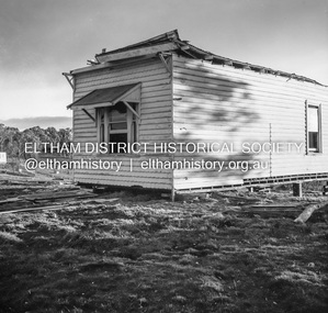
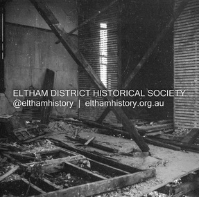
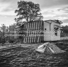
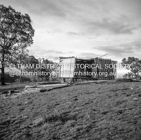
 Eltham District Historical Society Inc
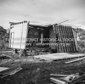
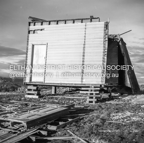
Negative - Photograph, J.A. McDonald, Inspection of storm damaged Abraham house at Kangaroo Ground, c. May 1962
... Inspection of storm damaged Abraham house at Kangaroo Ground...Inspection of storm damaged Abraham house at Kangaroo Ground Negative Photograph J.A. ...Showing the effect of a wind storm that destroyed the house circa May 1962.. The Abraham family owned land near the Aqueduct and east of Nicholas Lane at Kangaroo Ground (based on photos, at or near 40 Nicholas Lane).Record of various Shire of Eltham infrastructure works undertaken during the period of 1952-1962 involving bridge and road reconstruction projects, sometimes with Eltham Shire Council Project Reference numbers quoted. It was during this period that a number of significant improvements were made to roads and new bridges constructed within the shire that remain in place as of present day (2022). In many situations, the photos provide a tangible visible record of infrastructure that existed throughout the early days of the Shire. The album was put together by or under the direction of the Shire Engineer, J.A. McDonald.1962-05, abraham house, kangaroo ground, nicholas lane, property damage, storm damage -
 Eltham District Historical Society Inc
Negative - Photograph, J.A. McDonald, Inspection of storm damaged Abraham house at Kangaroo Ground, c. May 1962
... Inspection of storm damaged Abraham house at Kangaroo Ground...McDonald. 1962-05 Abraham house Kangaroo Ground Nicholas Lane Property damage Storm damage Building Surveyor George E. ...Showing the effect of a wind storm that destroyed the house circa May 1962.. The Abraham family owned land near the Aqueduct and east of Nicholas Lane at Kangaroo Ground (based on photos, at or near 40 Nicholas Lane).Record of various Shire of Eltham infrastructure works undertaken during the period of 1952-1962 involving bridge and road reconstruction projects, sometimes with Eltham Shire Council Project Reference numbers quoted. It was during this period that a number of significant improvements were made to roads and new bridges constructed within the shire that remain in place as of present day (2022). In many situations, the photos provide a tangible visible record of infrastructure that existed throughout the early days of the Shire. The album was put together by or under the direction of the Shire Engineer, J.A. McDonald.1962-05, abraham house, kangaroo ground, nicholas lane, property damage, storm damage, building surveyor, george e. newton -
 Eltham District Historical Society Inc
Negative - Photograph, J.A. McDonald, Inspection of storm damaged Abraham house at Kangaroo Ground, c. May 1962
... Inspection of storm damaged Abraham house at Kangaroo Ground...Inspection of storm damaged Abraham house at Kangaroo Ground Negative Photograph J.A. ...Showing the effect of a wind storm that destroyed the house circa May 1962.. The Abraham family owned land near the Aqueduct and east of Nicholas Lane at Kangaroo Ground (based on photos, at or near 40 Nicholas Lane).Record of various Shire of Eltham infrastructure works undertaken during the period of 1952-1962 involving bridge and road reconstruction projects, sometimes with Eltham Shire Council Project Reference numbers quoted. It was during this period that a number of significant improvements were made to roads and new bridges constructed within the shire that remain in place as of present day (2022). In many situations, the photos provide a tangible visible record of infrastructure that existed throughout the early days of the Shire. The album was put together by or under the direction of the Shire Engineer, J.A. McDonald.1962-05, abraham house, kangaroo ground, nicholas lane, property damage, storm damage -
 Eltham District Historical Society Inc
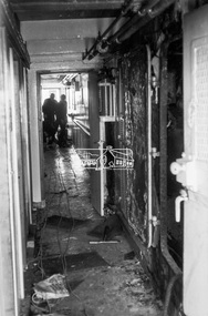
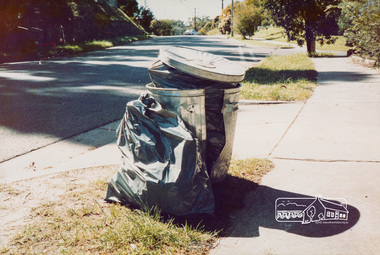
Photograph, Hazard to Garbage Collectors (Damaged bin, sharp objects in plastic bags)
... Hazard to Garbage Collectors (Damaged bin, sharp objects in plastic bags)...Eltham District Historical Society Inc 728 Main Rd Eltham melbourne One of a set of display images thought to be produced by the Shire of Eltham c.1979-1987 Illustrative of services provided by former Shire of Eltham bin collection waste disposal rubbish bin Title printed on label adhered to board below photograph (replaced June 2017) Colour photograph 20 x 29 cm mounted on green-painted chipboard 28 x 35.5 cm (string on back for hanging) Hazard to Garbage Collectors (Damaged bin, sharp objects in plastic bags) Photograph ...One of a set of display images thought to be produced by the Shire of Eltham c.1979-1987Illustrative of services provided by former Shire of ElthamColour photograph 20 x 29 cm mounted on green-painted chipboard 28 x 35.5 cm (string on back for hanging)Title printed on label adhered to board below photograph (replaced June 2017)bin collection, waste disposal, rubbish bin -
 Eltham District Historical Society Inc
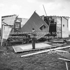
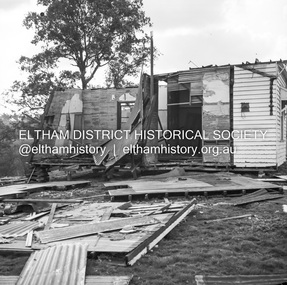
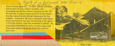
Photograph, Eltham Christian School, severely damaged by a deliberate fire, 10 October 1989, 1989
... Eltham Christian School, severely damaged by a deliberate fire, 10 October 1989...See also entries for each photograph. eltham christian school nyora road fire damage Typed letter printed on yellow paper with a black and white photograph Eltham Christian School, severely damaged by a deliberate fire, 10 October 1989 Photograph ...Part of a personal letter from a church member printed on yellow paper with a black and white photograph. Transcription: "And so home again to .. a fire!! Eltham Christina School and Church, where I worship was extensively burned by a known arsonist on Oct 10 (1998). We lost tthe 3 school rooms and 2/3 of the church. Another school kindly offered classrooms for the children. November 28 and a makesafe wall means school and church are now functioning in the good 1/3 of the church, until the remainder is rebuilt. So many have ministered to us in so many ways over these past weeks and we do thank the Lord for each one." The Stokes family settled in this area of Eltham in the 1940s and were associated with the Eltham Christian Church. In the 1970s this church had met in temporary premises in Eltham. Lots of the original 1920s subdivision remained south of Nyora Road and a number of these lots were utilized for the Eltham Christian School, which was established by the Eltham Christian Church in 1981. The school operated on this site until 2000. The premises were owned by the Nillumbik Community Church who were in operation till November 2010 when the Eltham Baptist Church commenced a lease arrangement until the site was purchased by them in April 2012. The building is constructed of brick and timber with a balcony on two sides that looks over an expanse of grass. Sources: STOKES ORCHARD – AN INCOMPLETE HISTORY February 28, 2015 http://www.elthamhistory.org.au/ Australian Christian Church Histories - Eltham Baptist Church http://www.churchhistories.net.au/church-catalog/eltham-vic-baptist/ From a magnetic spiral bound photo album featuring a series of photographs (some cropped) with captions relating to the staff, students and activities of the Eltham Christian School which operated as part of the Eltham Christian Church at Nyora Road, Eltham. See also entries for each photograph.Typed letter printed on yellow paper with a black and white photographeltham christian school, nyora road, fire damage -
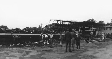 Ringwood and District Historical Society
Photograph, Eastwood State School, Alexandra Road, Ringwood East, severely damaged by fire - 2 May, 1970
... Eastwood State School, Alexandra Road, Ringwood East, severely damaged by fire - 2 May, 1970....Black and white photographs (7 images) Eastwood State School, Alexandra Road, Ringwood East, severely damaged by fire - 2 May, 1970. Photograph ...Black and white photographs (7 images)Printed below photograph, "Eastwood State School fire - 1970". Written on backing sheet, "See page 6 Ringwood Mail, 1/7/1970". -
 Ballarat Tramway Museum
Newspaper, The Courier Ballarat, Photo of No. 24 damaged, 1954
... Photo of No. 24 damaged...See Reg Item 3861 for other photographs. Photo of No. 24 damaged Newspaper The Courier Ballarat ...Yields information about the accidents and derailments in Ballarat and collisions with buildings.Newspaper clipping from The Courier, 9/5/54 (Wal has written 8/5/54) under the cutting about the runaway of No. 24 from Sturt and Lydiard Sts into the Bucks Head Hotel Has two photographs and eye witness accounts, details of passengers, hotel family and tramway men who attended. Contained within Reg Item 5507 - Foolscap binder with green covers, black binding edge and metal clips. See Reg Item 3861 for other photographs.derailments, 24, bridge st, bucks head hotel, accidents -
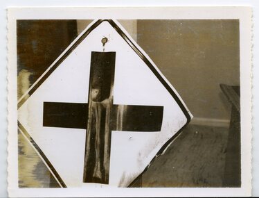 City of Whittlesea
Sign (item), Crossing Road Sign damaged by vandals, located at corner Bridge Inn Road and Reids Lane Doreen, 19/6/63
... Crossing Road Sign damaged by vandals, located at corner Bridge Inn Road and Reids Lane Doreen, 19/6/63,...City of Whittlesea 25 Ferres Boulevard South Morang melbourne sign sign, colour Crossing Road Sign damaged by vandals, located at corner Bridge Inn Road and Reids Lane Doreen, 19/6/63, Sign Sign ...sign -
 Mrs Aeneas Gunn Memorial Library
Book, Cassell, Bombed London : a collection of thirty-eight drawings of historic buildings damaged during the bombing of London in the second World War1939-1945, 1947
... Bombed London : a collection of thirty-eight drawings of historic buildings damaged during the bombing of London in the second World War1939-1945...Bombed London : a collection of thirty-eight drawings of historic buildings damaged during the bombing of London in the second World War1939-1945 Book Cassell Hanslip Fletcher ...An illustration of the destruction in London during World war twoIll,text.An illustration of the destruction in London during World war twolondon - destruction, london - second world war