Showing 210 items matching "dams - victoria"
-
 Falls Creek Historical Society
Photograph - Building Rocky Valley Dam Wall
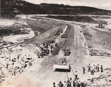
... The Rocky Valley Dam is located on the Bogong High Plains, near Falls Creek, Victoria. The dam is man-made and has a capacity of 28,000 megalitres (990×106 cu ft). ...Three black and white images showing work on the Rocky Valley Dam, Victoria...Falls Creek Historical Society Slalom Street Falls Creek The Rocky Valley Dam is located on the Bogong High Plains, near Falls Creek, Victoria. The dam is man-made and has a capacity of 28,000 megalitres (990×106 cu ft). ...The Rocky Valley Dam is located on the Bogong High Plains, near Falls Creek, Victoria. The dam is man-made and has a capacity of 28,000 megalitres (990×106 cu ft). At an elevation of 1600m, Rocky Valley Dam is the highest significant body of water in Australia. The dam was created for the Kiewa Hydroelectric Scheme. Just a short distance from the heart of the village, the lake provides a playground for a range of aquatic activities. It is also utilised in snow making for the Falls Creek ski resort. Work began on the Rocky Valley Dam site in early 1947 and continued until May. It resumed in October after the winter and a camp for the accommodation of workmen was commenced at this time. Work continued in 1948 with the establishment of work facilities, including the erection of two large excavators. The Rocky Valley Dam was completed in 1959.These images are significant as they capture work carried out to build the wall at Rocky Valley near Falls Creek, VictoriaThree black and white images showing work on the Rocky Valley Dam, Victoriarocky valley dam, kiewa hydroelectric scheme, falls creek -
 Mont De Lancey
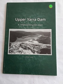
Book, Shirley Tunaley, Upper Yarra Dam: A 1950's Construction Town, 2007
... Dam - history...Melbourne Water...Dams - Victoria...Upper Yarra Dam - history Melbourne Water Dams - Victoria This book documents the 10-year, purpose-built community created for workers and families constructing the Upper Yarra Reservoir, a vital, post-WWII water project completed in 1957. ...This book documents the 10-year, purpose-built community created for workers and families constructing the Upper Yarra Reservoir, a vital, post-WWII water project completed in 1957. The site near Warburton, Victoria, housed over 800 residents, featuring schools, shops, and recreational facilities before being decommissioned.A green covered paperback book with the title printed in white and a black and white aerial photograph of the town and dam. The author's name is below. There is a green price sticker on the top right of the front cover. On the back of the front cover is a dedication to the author's father. There is an Introduction, a message from Melbourne Water, Contents, List of residents, a poem by Ken Dawson, Bibliography and Tribute inside the back cover. there re There are photographs, maps diagrams and information about the lives of the people. Pp.64. non-fictionThis book documents the 10-year, purpose-built community created for workers and families constructing the Upper Yarra Reservoir, a vital, post-WWII water project completed in 1957. The site near Warburton, Victoria, housed over 800 residents, featuring schools, shops, and recreational facilities before being decommissioned. upper yarra dam - history, melbourne water, dams - victoria -
 Ballarat Heritage Services
Photograph, Maryborough Water Supply
... Photograph of men standing along a dam wall at Maryborough, Victoria....Ballarat Heritage Services PO Box 2209 Bakery Hill Post Office goldfields maryborough maryborough water supply Photograph of men standing along a dam wall at Maryborough, Victoria. Maryborough Water Supply Photograph ...Photograph of men standing along a dam wall at Maryborough, Victoria.maryborough, maryborough water supply -
 Bendigo Historical Society Inc.
Document - VICTORIA HILL - NOTES ON SIGNS FOR VICTORIA HILL
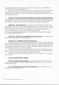
... dam... Victoria Quartz Mine...Sign posts listed are for: Ballerstedt's First open Cut, Quartz Veins (Spurs), Prospecting Shafts 1929, Engine beds for Lansell's big 180 Mine, 20 Head Crushing Battery Stampers, concrete dam, Victoria Quartz Mine, Foundations of steel poppet legs of the Victoria Quartz Mine, Victoria Quartz Dams, Rae's Open Cut, Site where the quartz was roasted, Anticlinal Arch , coloured rock formations, primitive tunnels, Adit, Engine bed for Great Central Victoria, Prospecting Tunnels, Great Central Victoria (Midway). ...Sign posts listed are for: Ballerstedt's First open Cut, Quartz Veins (Spurs), Prospecting Shafts 1929, Engine beds for Lansell's big 180 Mine, 20 Head Crushing Battery Stampers, concrete dam, Victoria Quartz Mine, Foundations of steel poppet legs of the Victoria Quartz Mine, Victoria Quartz Dams, Rae's Open Cut, Site where the quartz was roasted, Anticlinal Arch , coloured rock formations, primitive tunnels, Adit, Engine bed for Great Central Victoria, Prospecting Tunnels, Great Central Victoria (Midway). ...Three page typed copy of notes for signs on Victoria Hill. Mentions items to be seen at Victoria Hill. Sign posts listed are for: Ballerstedt's First open Cut, Quartz Veins (Spurs), Prospecting Shafts 1929, Engine beds for Lansell's big 180 Mine, 20 Head Crushing Battery Stampers, concrete dam, Victoria Quartz Mine, Foundations of steel poppet legs of the Victoria Quartz Mine, Victoria Quartz Dams, Rae's Open Cut, Site where the quartz was roasted, Anticlinal Arch , coloured rock formations, primitive tunnels, Adit, Engine bed for Great Central Victoria, Prospecting Tunnels, Great Central Victoria (Midway). Notes prepared by Albert Richardson.document, victoria hill, notes on signs for victoria hill, gold mines hotel, ballerstedt's first open cut, quartz veins (spurs), prospecting shafts 1929, engine beds for lansell's big 180 mine, 20 head crushing battery stampers, concrete dam, victoria quartz mine, foundations of steel poppet legs of the victoria quartz mine, victoria quartz dams, rae's open cut, site where the quartz was roasted, anticlinal arch , coloured rock formations, primitive tunnels, adit, engine bed for great central victoria, prospecting tunnels, great central victoria (midway), a richardson -
 Bendigo Historical Society Inc.
Pamphlet - Aileen and John Ellison collection: Eppalock dam
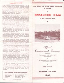
... State Rivers and water Supply Commission of Victoria. Eppalock Dam on the Campaspe River. Official commencement ceremony performed by the Honorable H.E. ...History House 11 Mackenzie Street Bendigo goldfields BHS Collection Lake Eppalock Eppalock Dam State Rivers and water Supply Commission of Victoria. Eppalock Dam on the Campaspe River. ...BHS CollectionState Rivers and water Supply Commission of Victoria. Eppalock Dam on the Campaspe River. Official commencement ceremony performed by the Honorable H.E. Bolte MLA Premier of Victoria and the Honorable W.J.Mibus MLA minister of water supply at Eppalock on Thursday, 9th June 1960. lake eppalock, eppalock dam -
 Lakes Entrance Historical Society
Photograph - Mossiface Flats, Tambo Shire, 1994
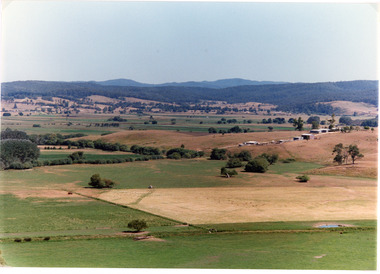
... Farm buildings in foreground and background. Dam in foreground. Bruthen Victoria...Farm buildings in foreground and background. Dam in foreground. Bruthen Victoria Photograph Mossiface Flats Tambo Shire ...Also second identical copyColour photograph of the Mossiface Flats, near Bruthen, shows paddocks of the rich river flats, timbered foothills in the distance, with mountain range behind. Some paddocks have been mown for grass hay. Farm buildings in foreground and background. Dam in foreground. Bruthen Victoriaanimals, agriculture, vegetation, topography -
 Falls Creek Historical Society
Photograph - Bernhardt Plohberger and Felix Soratroi near Falls Creek Ski School
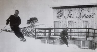
... After leaving Falls Creek, Bernie and Trudi moved to Canberra where Bernie took work on civil engineering projects such as the coal loader in Wollongong, the Vietnam memorial in Canberra, highway work on the Hume and Sugarloaf Dam in Victoria. Bernie Plohberger died on 18 May 2020. ...After leaving Falls Creek, Bernie and Trudi moved to Canberra where Bernie took work on civil engineering projects such as the coal loader in Wollongong, the Vietnam memorial in Canberra, highway work on the Hume and Sugarloaf Dam in Victoria. Bernie Plohberger died on 18 May 2020. ...Bernard Plohberger was one of the early ski instructors at Falls Creek. He was born in Austria on 14 January 1930. He was a ski instructor before he left Austria in 1955. He spent the winter of 1956 working as a ski instructor and during the summer Bernie worked as a chainman for the SEC Surveyor. He built the Ski School at Falls Creek in 1957 as well as the Frying Pan Inn. In 1960 the Frying Pan Inn was taken over by Bill Bridgford who had helped to finance its construction. Bernie married his wife Trudi in 1958 and their son Gerhard was born at the ski school in 1959, the first child born at Falls Creek. Both Trudi and Bernie worked for Bob Hymans for a period at Grand Coeur Chalet. After leaving Falls Creek, Bernie and Trudi moved to Canberra where Bernie took work on civil engineering projects such as the coal loader in Wollongong, the Vietnam memorial in Canberra, highway work on the Hume and Sugarloaf Dam in Victoria. Bernie Plohberger died on 18 May 2020. Felix Soratroi was also an Austrian Ski Instructor who was encouraged by Bernie to move to Falls Creek and work at the Ski School.This item is significant because it depicts early Ski Instructors at Falls Creek Ski School.A black and white image of two skiers near the Falls Creek Ski School.bernard plohberger, frying pan inn, falls creek ski school, felix soratroi -
 Bendigo Historical Society Inc.
Document - FOUR LETTERS FROM J H (JOHNTER) BARKER
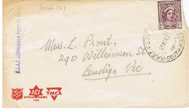
... Dated 8 June 1943 written from 5 RD, Rocklands Dam, via Hamilton, Victoria. b. Dated 14 July 1943 from same address as (a). ...Dated 8 June 1943 written from 5 RD, Rocklands Dam, via Hamilton, Victoria. b. Dated 14 July 1943 from same address as (a). ...Letters. Four letters written in pencil from J H (Johnter) Barker to his aunt Miss L Prout, 290 Williamson St, Bendigo. J H Barker belonged to RAAF, Flight 146 in 1943. a. Dated 8 June 1943 written from 5 RD, Rocklands Dam, via Hamilton, Victoria. b. Dated 14 July 1943 from same address as (a). c. Dated 25 July 1943 from same address as (a). d. Dated August 1943 written from RAAF, Adelaide. All letters written on RAAF letterhead except item (a). All letters with envelope except item (d). 'RAAF Concessional Postage Rate' stamped on envelopes. Salvation Army, ACF and YMCA logos printed in red on envelopes.J H Barkerperson, individual, personal, j h barker, johnter, miss l prout, raaf, ww2 letters -
 Bendigo Historical Society Inc.
Document - VICTORIA HILL - NOTES ON VICTORIA HILL (SIGNS)
... ... Victoria Quartz Dams...Victoria Hill. Signs indicate the feature and a description including Prospecting Shafts, dams, engine beds, Lansell's Big 180 Shaft, stampers, Victoria Quartz Mine, Victoria Quartz Dams, Rae's Open Cut, Anticlinal Arch, small primitive tunnels, Engine-bed for Great Central Victoria known as 'Midway' mine, prospecting tunnels, floyd's small 5 Head Crushing Battery, Ballerstedt's Small 24 Yard Claim, The Humboldt 1856 to 1861, Luffsman and Sterry's Claim, and A Round Shaft....Signs indicate the feature and a description including Prospecting Shafts, dams, engine beds, Lansell's Big 180 Shaft, stampers, Victoria Quartz Mine, Victoria Quartz Dams, Rae's Open Cut, Anticlinal Arch, small primitive tunnels, Engine-bed for Great Central Victoria known as 'Midway' mine, prospecting tunnels, floyd's small 5 Head Crushing Battery, Ballerstedt's Small 24 Yard Claim, The Humboldt 1856 to 1861, Luffsman and Sterry's Claim, and A Round Shaft. ...Twelve handwritten copied pages (a & b) of notes with typed copy of same, regarding the signs for Victoria Hill. Signs indicate the feature and a description including Prospecting Shafts, dams, engine beds, Lansell's Big 180 Shaft, stampers, Victoria Quartz Mine, Victoria Quartz Dams, Rae's Open Cut, Anticlinal Arch, small primitive tunnels, Engine-bed for Great Central Victoria known as 'Midway' mine, prospecting tunnels, floyd's small 5 Head Crushing Battery, Ballerstedt's Small 24 Yard Claim, The Humboldt 1856 to 1861, Luffsman and Sterry's Claim, and A Round Shaft.document, memo, victoria hill, victoria hill, notes on victoria hill (signs), lansell's big 180, ballerstedt senior, george lansell, victoria quartz mine, victoria reef quartz coy, wm rae, a roberts & sons, mr e j dunn, new chum drainage scheme, eureka extended, new chum railway, pearl, bendigo advertiser, inrush of water at the victoria quartz, victoria consols, shamrock, shenandoah, victoria quartz dams, rae's open cut. prospecting tunnel, floyd's small 5 head crushing battery, great central victoria (midway), midway no 2, midway north, ballerstedt's small 24 yard claim, the humboldt, wittscheibe, the adventure, advance, george lansell, luffsman & sterry's claim, david sterry, gold mines hotel, city of sandhurst, lansell's fortuna, a richardson -
 Bendigo Historical Society Inc.
Document - VICTORIA HILL - THE RICH VICTORIA HILL AND ITS HISTORICAL ASSOCIATIONS
... ... Victoria Quartz Dams...Notes include Introduction, directions for getting to Victoria Hill, North Old Chum Mine 2310 ft deep, Ballerstedt's First Open Cut, Geographical Features, Lansell's Big 180, Crushing Battery, Lansell's Cleopatra Needle type chimney, Victoria Quartz Mine 4613 ft deep, Victoria Reef Quartz Company, Victoria Quartz Company, Victoria Quartz Dams, Rae's Open Cut, Quartz Roasting, Floyd's small 5 Head Crushing Battery, Great Central Victoria (Midway) Shaft, Ballerstedt's Small 24 yard Claim, The Humboldt, The Adventure, The Advance and Luffsman and Sterry's Claim. ...Notes include Introduction, directions for getting to Victoria Hill, North Old Chum Mine 2310 ft deep, Ballerstedt's First Open Cut, Geographical Features, Lansell's Big 180, Crushing Battery, Lansell's Cleopatra Needle type chimney, Victoria Quartz Mine 4613 ft deep, Victoria Reef Quartz Company, Victoria Quartz Company, Victoria Quartz Dams, Rae's Open Cut, Quartz Roasting, Floyd's small 5 Head Crushing Battery, Great Central Victoria (Midway) Shaft, Ballerstedt's Small 24 yard Claim, The Humboldt, The Adventure, The Advance and Luffsman and Sterry's Claim. ...Copy and a photocopy of notes titled 'The rich Victoria Hill and its Historical Associations. The photocopy does not have copies of the photos. Notes include Introduction, directions for getting to Victoria Hill, North Old Chum Mine 2310 ft deep, Ballerstedt's First Open Cut, Geographical Features, Lansell's Big 180, Crushing Battery, Lansell's Cleopatra Needle type chimney, Victoria Quartz Mine 4613 ft deep, Victoria Reef Quartz Company, Victoria Quartz Company, Victoria Quartz Dams, Rae's Open Cut, Quartz Roasting, Floyd's small 5 Head Crushing Battery, Great Central Victoria (Midway) Shaft, Ballerstedt's Small 24 yard Claim, The Humboldt, The Adventure, The Advance and Luffsman and Sterry's Claim. Copies of photos include: Victoria Hill from Rae's Open Cut, Looking North from Old Chum Hill to the Victoria Hill, the Victoria Quartz Mine and Wm. Rae's Crushing Works.document, gold, victoria hill, the rich victoria hill and its historical associations, j n macartney, quartz miners' arms hotel, ironbark methodist church, john brown knitwear factory, little 180, george lansell, conrad heinz, british and american hotel, victoria reef gold mining company, manchester arms hotel, housing commission homes, the ironbark, hercules and energetic, midway, wittscheibe, great central victoria, wm rae, mr & mrs conroy, moorhead's shop, central nell gwynne, gold mines hotel, david chaplin sterry, new chum & victoria, old chum, burrowes & sterry, rotary club of bendigo south, big 180, north old chum mine, ballerstedt's first open-cut, lansell's bit 180 shaft, victoria quartz mine, victoria reef quartz company, a roberts & sons, mr e j dunn, h harkness & sons, new chum drainage scheme, eureka extended, new chum railway, the pearl, inrush of water, shamrock, shenandoah, victoria quartz dams, rae's open cut, floyd's small 5 head crushing battery, great central victoria (midway) shaft, midway no 2, midway north, the humboldt, the adventure, the advance, luffsman & sterry's claim, chinese joss house, fortuna, p m g repeater station, bendigo and vicinity 1895, j n macartney 1st edition 1871, mr rae anderson, 'gill family, annals of bendigo obituary notices 1904, mining records and australian mining standard special edition 1/6/1899, bendigo advertiser 22/6/1871, b m l records mines department, patterson's goldfields of victoria, dickers mining record 23/11/1861, annals of bendigo, bendigo advertiser 24/7/1933, 27/8/1908, 30/6/1910, 16/6/1910, 17/6/1910, mining reports for 1910, australian mining standard special edition 1/6/1899 p40, bendigo mines ltd, mines department records, the bendigo goldfield 1851 to 1954, the victoria hill 1854 to 1949, wm rae's crushing works -
 Falls Creek Historical Society
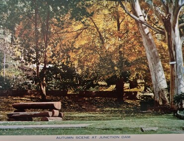
Postcard - Junction Dam, Kiewa Hydroelectric Scheme
... Samuel Keith Pearce died on 7 July 1994 in Mount Beauty, Victoria Junction Dam, also known as Lake Guy, is situated 16 kms from Mt Beauty, along the Bogong High Plains Road. ...Samuel Keith Pearce died on 7 July 1994 in Mount Beauty, Victoria Junction Dam, also known as Lake Guy, is situated 16 kms from Mt Beauty, along the Bogong High Plains Road. ...These photographs were taken in and around Mount Beauty and the Kiewa Valley by Samuel Keith Pearce and printed for him as a foldout postcard by NuColor Vue. The postcards state they were printed for S. K. Pearce Pty. Ltd of Tawonga and Mount Beauty. Samuel Keith Pearce was born on 24 June 1917 in Armadale, Victoria. By the late 1940s he owned the Mt Beauty Supermarket, Newsagency, Drapery and Hardware store at Mount Beauty and also a store at Tawonga in partnership with his brother Gordon Cathew Pearce. For some time, they operated as Pearce Brothers. In the early 1960s Keith also opened a mini mart In Falls Creek. As well as being a keen photographer and an astute businessman, Keith Pearce was a well-known identity in the Kiewa Valley, making many contributions to the development of the area over a long period. This included serving as a member of the Bright Shire Council for many years. He worked hard to promote the interests of the Upper Kiewa Valley. As a sign of recognition and appreciation for his contribution to the community, the park opposite the grocery store in Mount Beauty was named the SK Pearce Gardens in his honour. Samuel Keith Pearce died on 7 July 1994 in Mount Beauty, Victoria Junction Dam, also known as Lake Guy, is situated 16 kms from Mt Beauty, along the Bogong High Plains Road. It was built by the State Electricity Commission of Victoria as part of the Kiewa Hydro Electric Scheme. This collection of postcards and images is significant because they were commissioned by a highly successful businessman in Falls Creek, Victoria.A colour image of Junction Dam in the Upper Kiewa area, showing a bench and autumn trees.mt. beauty, junction dam, lake guy, kiewa hydroelectric scheme -
 Bendigo Historical Society Inc.
Document - RAE'S CRUSHING BATTERY - THE RICH VICTORIA HILL & ITS HISTORICAL ASSOCIATIONS
... Victoria Hill - from Rae's Open Cut. Introduction covers location of buildings and mines. Mentioned are:- North Old Chum Mine, Ballerstedt's First Open-cut, Quartz Veins (Spurs), rock formations pitching North, Prospecting shafts 1929, Concrete dam, Engine beds of Lansells Big 180 Mine, Lansells Big 180 Shaft, twenty stampers crushing battery, Lansell's Cleopatra Needle type chimney, Victoria Quartz Mine, Victoria Quartz dams, Rae's Open-cut, Quartz once roasted here to an intense heat, Anticlinal Arch New Chum Line, small primitive tunnels, Prospecting tunnels, Floyd's small 5 head crushing battery, Great Central Victoria (Midway) Shaft, Great Central Victoria engine-bed, Ballerstedt's small 24 yard claim, The Humboldt, Adventure ground, The Advance, Luffsman & Sterry's Claim, A round shaft. ...Victoria Hill - from Rae's Open Cut. Introduction covers location of buildings and mines. Mentioned are:- North Old Chum Mine, Ballerstedt's First Open-cut, Quartz Veins (Spurs), rock formations pitching North, Prospecting shafts 1929, Concrete dam, Engine beds of Lansells Big 180 Mine, Lansells Big 180 Shaft, twenty stampers crushing battery, Lansell's Cleopatra Needle type chimney, Victoria Quartz Mine, Victoria Quartz dams, Rae's Open-cut, Quartz once roasted here to an intense heat, Anticlinal Arch New Chum Line, small primitive tunnels, Prospecting tunnels, Floyd's small 5 head crushing battery, Great Central Victoria (Midway) Shaft, Great Central Victoria engine-bed, Ballerstedt's small 24 yard claim, The Humboldt, Adventure ground, The Advance, Luffsman & Sterry's Claim, A round shaft. ...The first five pages are photocopies of photos:- 2 of Rae's Crushing Works; Victoria Quartz on Victoria Hill, Ironbark; Looking North from Old Chum Hill to the Victoria Hill; Victoria Hill - from Rae's Open Cut. Introduction covers location of buildings and mines. Mentioned are:- North Old Chum Mine, Ballerstedt's First Open-cut, Quartz Veins (Spurs), rock formations pitching North, Prospecting shafts 1929, Concrete dam, Engine beds of Lansells Big 180 Mine, Lansells Big 180 Shaft, twenty stampers crushing battery, Lansell's Cleopatra Needle type chimney, Victoria Quartz Mine, Victoria Quartz dams, Rae's Open-cut, Quartz once roasted here to an intense heat, Anticlinal Arch New Chum Line, small primitive tunnels, Prospecting tunnels, Floyd's small 5 head crushing battery, Great Central Victoria (Midway) Shaft, Great Central Victoria engine-bed, Ballerstedt's small 24 yard claim, The Humboldt, Adventure ground, The Advance, Luffsman & Sterry's Claim, A round shaft. Small piece of paper with 'Notes on Victoria Hill complete. Notes prepared by Albert Richardson.document, gold, rae's crushing battery, rae's crushing battery, rae's crushing works, victoria quartz mine, from old chum hill, victoria hill from rae's open cut, ironbark, hercules & energetic, midway, wittscheibe, great central victoria, mr & mrs conroy, central nell gwynne, gold mines hotel, john brown knitwear factory, new chum & victoria, rotary club of bendigo south, north old chum, ballerstedt's first open-cut, lansell's big 180 shaft, cleopatra needle type chimney, a roberts & sons, mr e j dunn, h harkness & sons, eureka extd, new chum railway, pearl, inrush of water at victoria quartz, floyd's small 5 head crushing battery, great central victoria (midway), ballertedt's small 24 yard claim, humboldt, humboldt, great central victoria, victoria hill, bendigo & vicinity 1895 p51, j n macartney 1st edition 1871, bendigo goldfield registry 1871, plan of new chum line, mr rae anderson, annals of bendigo obituary 1904, bendigo advertiser, b m l records mines dept, patterson's goldfields of victoria, dickers mining record 23/11/1861, australian mining standard special edition 1/6/1899 p40, bendigo mines ltd, chinese joss house, fortuna, the victoria goldfield 1851 to 1954, the victoria hill 1854 to 1949 -
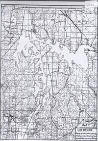
 Bendigo Historical Society Inc.
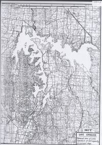
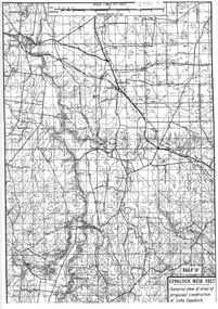
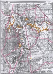
Map - Laminated map of Lake Eppalock at full capacity. Map 'E'
... The dam was built by the State Rivers and Water Supply Commission of Victoria. The dam wall height is 45 metres (148 ft) and the main embankment is 1,041 metres (3,415 ft) long. ...The dam was built by the State Rivers and Water Supply Commission of Victoria. The dam wall height is 45 metres (148 ft) and the main embankment is 1,041 metres (3,415 ft) long. ...John Perry Collection. Laminated map of Lake Eppalock at full capacity. Black and white. The dam was built by the State Rivers and Water Supply Commission of Victoria. The dam wall height is 45 metres (148 ft) and the main embankment is 1,041 metres (3,415 ft) long. At 100% capacity the dam wall was designed to hold back 304,651 megalitres (6.7014×10¹⁰ imp gal; 8.0480×10¹⁰ US gal) of water. The surface area of Lake Eppalock is 3,011 hectares (7,440 acres) and the catchment area is 2,124 square kilometres (820 sq mi). The controlled spillway is capable of discharging 8,040 cubic metres per second (284,000 cu ft/s). Lake Eppalock supplies both stock and domestic water to the Campaspe irrigation district. It also serves as a water supply to Bendigo and Heathcote and, in more recent times, Ballarat. The lake is a major attraction for those engaging in watersports, with a number of tourist parks and accommodation facilities available. Permissible activities on the lake include high-speed boating, water skiing, sailing, canoeing, fishing and swimming. The lake's water levels were low for approximately eight years between 2002 and 2010 during a prolonged drought, which restricted the amount of recreational activity until rainfall in the latter half of 2010 returned the lake to 100 percent capacity. Built between 1961 and 1964, Lake Eppalock remains the only water storage on the Campaspe River system.map, eppalock, water, dam, reservoir -
 Bendigo Historical Society Inc.
Document - VICTORIA HILL - KEY TO SIGN POSTS ON AREA MAP
... Victoria Hill. No 1 North Old Chum Shaft, No 2 Ballerstedt's First Open - Cut. Special Sign Post, No 2 C Rock Formations Pitching North, No 2 B Rich shallow shafts, No 2 A Quartz veins, No 4 A Concrete Dams, No 3 Engine Beds - Lansell's 'Big 180' Mine, No 3 B Lansell's 'Big 180' Shaft, No 4 Twenty Stampers Crushing Battery, No 3 C Foundations - 'Cleopatra Needle' type Chimney for Lansell's 'big 180' Mine, No 5 Victoria Quartz Mine, No 5 A Fou;ndations Victoria Quartz Poppet Legs, No 5 C Foundations Victoria Quartz Winding Plant, No 5 B Victoria Quartz Dams, No 6 Rae's Open - Cut, No 9 Quartz Once Roasted Here, No 12 Anticlinal Arch, No 15 primitive Tunnels, No 14 Beautifully Coloured Rock Formations, No 16 Adit, Graded Bedding, Oblique Fault, Spurry Quartz Veins, No 17 Prospecting Tunnels, No 18 Floyd's Small Crushing Battery, No 19 Gt Central Victoria (Midway) Shaft, No 20 Great Central Victoria (Midway) Engine Bed, No 21 ballerstedt's Small 24 Yard Claim, No 22 Humboldt Shaft, No 23 Wittscheibe's 'Jeweller's Shop', No 24 The 'Adventure' ground, Large Open - Cut, No 26 Luffsman and Sterry's Ground, NO 27 A Round Shaft, Notes prepared by Albert Richardson....Victoria Hill. No 1 North Old Chum Shaft, No 2 Ballerstedt's First Open - Cut. Special Sign Post, No 2 C Rock Formations Pitching North, No 2 B Rich shallow shafts, No 2 A Quartz veins, No 4 A Concrete Dams, No 3 Engine Beds - Lansell's 'Big 180' Mine, No 3 B Lansell's 'Big 180' Shaft, No 4 Twenty Stampers Crushing Battery, No 3 C Foundations - 'Cleopatra Needle' type Chimney for Lansell's 'big 180' Mine, No 5 Victoria Quartz Mine, No 5 A Fou;ndations Victoria Quartz Poppet Legs, No 5 C Foundations Victoria Quartz Winding Plant, No 5 B Victoria Quartz Dams, No 6 Rae's Open - Cut, No 9 Quartz Once Roasted Here, No 12 Anticlinal Arch, No 15 primitive Tunnels, No 14 Beautifully Coloured Rock Formations, No 16 Adit, Graded Bedding, Oblique Fault, Spurry Quartz Veins, No 17 Prospecting Tunnels, No 18 Floyd's Small Crushing Battery, No 19 Gt Central Victoria (Midway) Shaft, No 20 Great Central Victoria (Midway) Engine Bed, No 21 ballerstedt's Small 24 Yard Claim, No 22 Humboldt Shaft, No 23 Wittscheibe's 'Jeweller's Shop', No 24 The 'Adventure' ground, Large Open - Cut, No 26 Luffsman and Sterry's Ground, NO 27 A Round Shaft, Notes prepared by Albert Richardson. ...Three page hand written carbon copy of Sign numbers at Victoria Hill. No 1 North Old Chum Shaft, No 2 Ballerstedt's First Open - Cut. Special Sign Post, No 2 C Rock Formations Pitching North, No 2 B Rich shallow shafts, No 2 A Quartz veins, No 4 A Concrete Dams, No 3 Engine Beds - Lansell's 'Big 180' Mine, No 3 B Lansell's 'Big 180' Shaft, No 4 Twenty Stampers Crushing Battery, No 3 C Foundations - 'Cleopatra Needle' type Chimney for Lansell's 'big 180' Mine, No 5 Victoria Quartz Mine, No 5 A Fou;ndations Victoria Quartz Poppet Legs, No 5 C Foundations Victoria Quartz Winding Plant, No 5 B Victoria Quartz Dams, No 6 Rae's Open - Cut, No 9 Quartz Once Roasted Here, No 12 Anticlinal Arch, No 15 primitive Tunnels, No 14 Beautifully Coloured Rock Formations, No 16 Adit, Graded Bedding, Oblique Fault, Spurry Quartz Veins, No 17 Prospecting Tunnels, No 18 Floyd's Small Crushing Battery, No 19 Gt Central Victoria (Midway) Shaft, No 20 Great Central Victoria (Midway) Engine Bed, No 21 ballerstedt's Small 24 Yard Claim, No 22 Humboldt Shaft, No 23 Wittscheibe's 'Jeweller's Shop', No 24 The 'Adventure' ground, Large Open - Cut, No 26 Luffsman and Sterry's Ground, NO 27 A Round Shaft, Notes prepared by Albert Richardson.mine, gold, victoria hill, victoria hill, victoria hill key to sign posts on area map, north old chum shaft, ballerstedt's first open cut, lansell's big 180 shaft, 'cleopatra needle' type chimney, victoria quartz mine, rae's open cut, prospecting tunnels, floyd's small crushing battery, gt central victoria (midway) shaft, ballerstedt's small 245 yard claim, humboldt shaft, wittscheibe's 'jeweller's shop', adventure, luffsman and sterry's ground, david sterry, sterry's 'gold mines' hotel, round shaft -
 Bendigo Historical Society Inc.
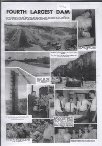
Document - Collection of photographs from newspaper on a single page
... The dam was built by the State Rivers and Water Supply Commission of Victoria. The dam wall height is 45 metres (148 ft) and the main embankment is 1,041 metres (3,415 ft) long. ...The dam was built by the State Rivers and Water Supply Commission of Victoria. The dam wall height is 45 metres (148 ft) and the main embankment is 1,041 metres (3,415 ft) long. ...John Perry Collection. Laminated copy of page from 'Weekly Times' newspaper, February, 1962. Nine images relating to establishing and building Eppalock Reservoir, 15 miles from Bendigo. The dam was built by the State Rivers and Water Supply Commission of Victoria. The dam wall height is 45 metres (148 ft) and the main embankment is 1,041 metres (3,415 ft) long. At 100% capacity the dam wall was designed to hold back 304,651 megalitres (6.7014×10¹⁰ imp gal; 8.0480×10¹⁰ US gal) of water. The surface area of Lake Eppalock is 3,011 hectares (7,440 acres) and the catchment area is 2,124 square kilometres (820 sq mi). The controlled spillway is capable of discharging 8,040 cubic metres per second (284,000 cu ft/s). Lake Eppalock supplies both stock and domestic water to the Campaspe irrigation district. It also serves as a water supply to Bendigo and Heathcote and, in more recent times, Ballarat. The lake is a major attraction for those engaging in watersports, with a number of tourist parks and accommodation facilities available. Permissible activities on the lake include high-speed boating, water skiing, sailing, canoeing, fishing and swimming. The lake's water levels were low for approximately eight years between 2002 and 2010 during a prolonged drought, which restricted the amount of recreational activity until rainfall in the latter half of 2010 returned the lake to 100 percent capacity. Built between 1961 and 1964, Lake Eppalock remains the only water storage on the Campaspe River system. dam, engineering, water, eppalock -
 Bendigo Historical Society Inc.
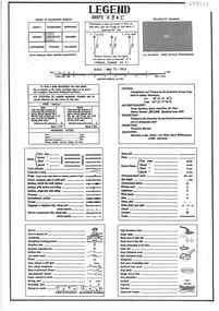
Document - Legend to maps A, B and C for Lake Eppalock
... The dam was built by the State Rivers and Water Supply Commission of Victoria. The dam wall height is 45 metres (148 ft) and the main embankment is 1,041 metres (3,415 ft) long. ...The dam was built by the State Rivers and Water Supply Commission of Victoria. The dam wall height is 45 metres (148 ft) and the main embankment is 1,041 metres (3,415 ft) long. ...John Perry Collection. Laminated 'legend' for Maps A, B and C for Lake Eppalock also in this collection. Black and White definitions and descriptions of objects and markers found on maps. Circa 1951. The dam was built by the State Rivers and Water Supply Commission of Victoria. The dam wall height is 45 metres (148 ft) and the main embankment is 1,041 metres (3,415 ft) long. At 100% capacity the dam wall was designed to hold back 304,651 megalitres (6.7014×10¹⁰ imp gal; 8.0480×10¹⁰ US gal) of water. The surface area of Lake Eppalock is 3,011 hectares (7,440 acres) and the catchment area is 2,124 square kilometres (820 sq mi). The controlled spillway is capable of discharging 8,040 cubic metres per second (284,000 cu ft/s). Lake Eppalock supplies both stock and domestic water to the Campaspe irrigation district. It also serves as a water supply to Bendigo and Heathcote and, in more recent times, Ballarat. The lake is a major attraction for those engaging in watersports, with a number of tourist parks and accommodation facilities available. Permissible activities on the lake include high-speed boating, water skiing, sailing, canoeing, fishing and swimming. The lake's water levels were low for approximately eight years between 2002 and 2010 during a prolonged drought, which restricted the amount of recreational activity until rainfall in the latter half of 2010 returned the lake to 100 percent capacity. Built between 1961 and 1964, Lake Eppalock remains the only water storage on the Campaspe River system.map, water, dam, reservoir, eppalock -
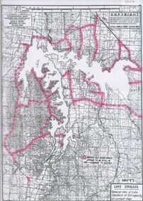
 Bendigo Historical Society Inc.
Map - General view of area of proposed construction of Lake Eppalock. Map 'A'
... The dam was built by the State Rivers and Water Supply Commission of Victoria. The dam wall height is 45 metres (148 ft) and the main embankment is 1,041 metres (3,415 ft) long. ...The dam was built by the State Rivers and Water Supply Commission of Victoria. The dam wall height is 45 metres (148 ft) and the main embankment is 1,041 metres (3,415 ft) long. ...John Perry Collection. Laminated map of proposed construction of Lake Eppalock. Map 'A'. Black and white map in laminate. Circa 1951. The dam was built by the State Rivers and Water Supply Commission of Victoria. The dam wall height is 45 metres (148 ft) and the main embankment is 1,041 metres (3,415 ft) long. At 100% capacity the dam wall was designed to hold back 304,651 megalitres (6.7014×10¹⁰ imp gal; 8.0480×10¹⁰ US gal) of water. The surface area of Lake Eppalock is 3,011 hectares (7,440 acres) and the catchment area is 2,124 square kilometres (820 sq mi). The controlled spillway is capable of discharging 8,040 cubic metres per second (284,000 cu ft/s). Lake Eppalock supplies both stock and domestic water to the Campaspe irrigation district. It also serves as a water supply to Bendigo and Heathcote and, in more recent times, Ballarat. The lake is a major attraction for those engaging in watersports, with a number of tourist parks and accommodation facilities available. Permissible activities on the lake include high-speed boating, water skiing, sailing, canoeing, fishing and swimming. The lake's water levels were low for approximately eight years between 2002 and 2010 during a prolonged drought, which restricted the amount of recreational activity until rainfall in the latter half of 2010 returned the lake to 100 percent capacity. Built between 1961 and 1964, Lake Eppalock remains the only water storage on the Campaspe River system.map, dam, water, weir, eppalock -
 Bendigo Historical Society Inc.
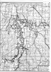
Map - Black and White map. Outline of Lake Eppalock. Map 'B'
... The dam was built by the State Rivers and Water Supply Commission of Victoria. The dam wall height is 45 metres (148 ft) and the main embankment is 1,041 metres (3,415 ft) long. ...The dam was built by the State Rivers and Water Supply Commission of Victoria. The dam wall height is 45 metres (148 ft) and the main embankment is 1,041 metres (3,415 ft) long. ...John Perry Collection. Laminated copy black and white map. Map 'B'. Outline of Lake Eppalcok, overlayed on map. Circa 1951. The dam was built by the State Rivers and Water Supply Commission of Victoria. The dam wall height is 45 metres (148 ft) and the main embankment is 1,041 metres (3,415 ft) long. At 100% capacity the dam wall was designed to hold back 304,651 megalitres (6.7014×10¹⁰ imp gal; 8.0480×10¹⁰ US gal) of water. The surface area of Lake Eppalock is 3,011 hectares (7,440 acres) and the catchment area is 2,124 square kilometres (820 sq mi). The controlled spillway is capable of discharging 8,040 cubic metres per second (284,000 cu ft/s). Lake Eppalock supplies both stock and domestic water to the Campaspe irrigation district. It also serves as a water supply to Bendigo and Heathcote and, in more recent times, Ballarat. The lake is a major attraction for those engaging in watersports, with a number of tourist parks and accommodation facilities available. Permissible activities on the lake include high-speed boating, water skiing, sailing, canoeing, fishing and swimming. The lake's water levels were low for approximately eight years between 2002 and 2010 during a prolonged drought, which restricted the amount of recreational activity until rainfall in the latter half of 2010 returned the lake to 100 percent capacity. Built between 1961 and 1964, Lake Eppalock remains the only water storage on the Campaspe River system.map, water, dam, reservoir, eppalock -
 Bendigo Historical Society Inc.
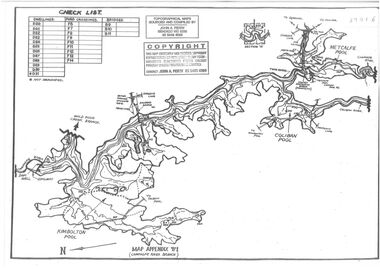
Map - Black and white map pertaining to Lake Eppalock
... The dam was built by the State Rivers and Water Supply Commission of Victoria. The dam wall height is 45 metres (148 ft) and the main embankment is 1,041 metres (3,415 ft) long. ...The dam was built by the State Rivers and Water Supply Commission of Victoria. The dam wall height is 45 metres (148 ft) and the main embankment is 1,041 metres (3,415 ft) long. ...John Perry Collection. Laminated copy of map relating to Lake Eppalock. Lists dwellings, ford crossings and bridges. The dam was built by the State Rivers and Water Supply Commission of Victoria. The dam wall height is 45 metres (148 ft) and the main embankment is 1,041 metres (3,415 ft) long. At 100% capacity the dam wall was designed to hold back 304,651 megalitres (6.7014×10¹⁰ imp gal; 8.0480×10¹⁰ US gal) of water. The surface area of Lake Eppalock is 3,011 hectares (7,440 acres) and the catchment area is 2,124 square kilometres (820 sq mi). The controlled spillway is capable of discharging 8,040 cubic metres per second (284,000 cu ft/s). Lake Eppalock supplies both stock and domestic water to the Campaspe irrigation district. It also serves as a water supply to Bendigo and Heathcote and, in more recent times, Ballarat. The lake is a major attraction for those engaging in watersports, with a number of tourist parks and accommodation facilities available. Permissible activities on the lake include high-speed boating, water skiing, sailing, canoeing, fishing and swimming. The lake's water levels were low for approximately eight years between 2002 and 2010 during a prolonged drought, which restricted the amount of recreational activity until rainfall in the latter half of 2010 returned the lake to 100 percent capacity. Built between 1961 and 1964, Lake Eppalock remains the only water storage on the Campaspe River system.map, water, dam, reservoir, eppalock -
 Bendigo Historical Society Inc.
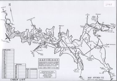
Map - Black and white map pertaining to Lake Eppalock
... The dam was built by the State Rivers and Water Supply Commission of Victoria. The dam wall height is 45 metres (148 ft) and the main embankment is 1,041 metres (3,415 ft) long. ...The dam was built by the State Rivers and Water Supply Commission of Victoria. The dam wall height is 45 metres (148 ft) and the main embankment is 1,041 metres (3,415 ft) long. ...John Perry Collection. Laminated copy of map pertaining to Lake Eppalock. Gives details of dwellings, bridges and ford crossings. The dam was built by the State Rivers and Water Supply Commission of Victoria. The dam wall height is 45 metres (148 ft) and the main embankment is 1,041 metres (3,415 ft) long. At 100% capacity the dam wall was designed to hold back 304,651 megalitres (6.7014×10¹⁰ imp gal; 8.0480×10¹⁰ US gal) of water. The surface area of Lake Eppalock is 3,011 hectares (7,440 acres) and the catchment area is 2,124 square kilometres (820 sq mi). The controlled spillway is capable of discharging 8,040 cubic metres per second (284,000 cu ft/s). Lake Eppalock supplies both stock and domestic water to the Campaspe irrigation district. It also serves as a water supply to Bendigo and Heathcote and, in more recent times, Ballarat. The lake is a major attraction for those engaging in watersports, with a number of tourist parks and accommodation facilities available. Permissible activities on the lake include high-speed boating, water skiing, sailing, canoeing, fishing and swimming. The lake's water levels were low for approximately eight years between 2002 and 2010 during a prolonged drought, which restricted the amount of recreational activity until rainfall in the latter half of 2010 returned the lake to 100 percent capacity. Built between 1961 and 1964, Lake Eppalock remains the only water storage on the Campaspe River system.eppalock, map, water, dam, reservoir -
 Bendigo Historical Society Inc.
Map - Map of overlay of lake Eppalock at full capacity. Map 'C'
... The dam was built by the State Rivers and Water Supply Commission of Victoria. The dam wall height is 45 metres (148 ft) and the main embankment is 1,041 metres (3,415 ft) long. ...The dam was built by the State Rivers and Water Supply Commission of Victoria. The dam wall height is 45 metres (148 ft) and the main embankment is 1,041 metres (3,415 ft) long. ...John Perry collection. Map 'C'. Laminated map of overlay of Lake Eppalock at full capacity. Circa 1951. The dam was built by the State Rivers and Water Supply Commission of Victoria. The dam wall height is 45 metres (148 ft) and the main embankment is 1,041 metres (3,415 ft) long. At 100% capacity the dam wall was designed to hold back 304,651 megalitres (6.7014×10¹⁰ imp gal; 8.0480×10¹⁰ US gal) of water. The surface area of Lake Eppalock is 3,011 hectares (7,440 acres) and the catchment area is 2,124 square kilometres (820 sq mi). The controlled spillway is capable of discharging 8,040 cubic metres per second (284,000 cu ft/s). Lake Eppalock supplies both stock and domestic water to the Campaspe irrigation district. It also serves as a water supply to Bendigo and Heathcote and, in more recent times, Ballarat. The lake is a major attraction for those engaging in watersports, with a number of tourist parks and accommodation facilities available. Permissible activities on the lake include high-speed boating, water skiing, sailing, canoeing, fishing and swimming. The lake's water levels were low for approximately eight years between 2002 and 2010 during a prolonged drought, which restricted the amount of recreational activity until rainfall in the latter half of 2010 returned the lake to 100 percent capacity. Built between 1961 and 1964, Lake Eppalock remains the only water storage on the Campaspe River system.map, water, eppalock, dam, reservoir -
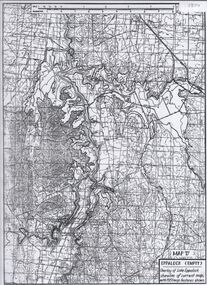 Bendigo Historical Society Inc.
Map - Laminated map of Lake Eppalock empty. Map 'D'
... The dam was built by the State Rivers and Water Supply Commission of Victoria. The dam wall height is 45 metres (148 ft) and the main embankment is 1,041 metres (3,415 ft) long. ...The dam was built by the State Rivers and Water Supply Commission of Victoria. The dam wall height is 45 metres (148 ft) and the main embankment is 1,041 metres (3,415 ft) long. ...John Perry Collection. Laminated map of Lake Eppalock empty. Map 'D'. Circa 1951. The dam was built by the State Rivers and Water Supply Commission of Victoria. The dam wall height is 45 metres (148 ft) and the main embankment is 1,041 metres (3,415 ft) long. At 100% capacity the dam wall was designed to hold back 304,651 megalitres (6.7014×10¹⁰ imp gal; 8.0480×10¹⁰ US gal) of water. The surface area of Lake Eppalock is 3,011 hectares (7,440 acres) and the catchment area is 2,124 square kilometres (820 sq mi). The controlled spillway is capable of discharging 8,040 cubic metres per second (284,000 cu ft/s). Lake Eppalock supplies both stock and domestic water to the Campaspe irrigation district. It also serves as a water supply to Bendigo and Heathcote and, in more recent times, Ballarat. The lake is a major attraction for those engaging in watersports, with a number of tourist parks and accommodation facilities available. Permissible activities on the lake include high-speed boating, water skiing, sailing, canoeing, fishing and swimming. The lake's water levels were low for approximately eight years between 2002 and 2010 during a prolonged drought, which restricted the amount of recreational activity until rainfall in the latter half of 2010 returned the lake to 100 percent capacity. Built between 1961 and 1964, Lake Eppalock remains the only water storage on the Campaspe River system.map, water, dam, reservoir, eppalock -
 Bendigo Historical Society Inc.
Map - Laminated map of Lake Eppalock at full capacity
... The dam was built by the State Rivers and Water Supply Commission of Victoria. The dam wall height is 45 metres (148 ft) and the main embankment is 1,041 metres (3,415 ft) long. ...The dam was built by the State Rivers and Water Supply Commission of Victoria. The dam wall height is 45 metres (148 ft) and the main embankment is 1,041 metres (3,415 ft) long. ...John Perry Collection. Laminated copy of map of Lake Eppalock at full capacity. Had highlighter markings of old roads which appear to be still in use. The dam was built by the State Rivers and Water Supply Commission of Victoria. The dam wall height is 45 metres (148 ft) and the main embankment is 1,041 metres (3,415 ft) long. At 100% capacity the dam wall was designed to hold back 304,651 megalitres (6.7014×10¹⁰ imp gal; 8.0480×10¹⁰ US gal) of water. The surface area of Lake Eppalock is 3,011 hectares (7,440 acres) and the catchment area is 2,124 square kilometres (820 sq mi). The controlled spillway is capable of discharging 8,040 cubic metres per second (284,000 cu ft/s). Lake Eppalock supplies both stock and domestic water to the Campaspe irrigation district. It also serves as a water supply to Bendigo and Heathcote and, in more recent times, Ballarat. The lake is a major attraction for those engaging in watersports, with a number of tourist parks and accommodation facilities available. Permissible activities on the lake include high-speed boating, water skiing, sailing, canoeing, fishing and swimming. The lake's water levels were low for approximately eight years between 2002 and 2010 during a prolonged drought, which restricted the amount of recreational activity until rainfall in the latter half of 2010 returned the lake to 100 percent capacity. Built between 1961 and 1964, Lake Eppalock remains the only water storage on the Campaspe River system.map, water, dam, reservoir, eppalock -
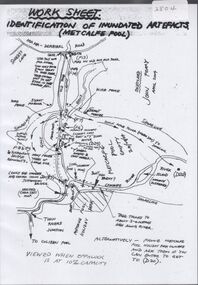 Bendigo Historical Society Inc.
Map - Laminated worksheet - identification of inundated artifacts at Lake Eppalock
... The dam was built by the State Rivers and Water Supply Commission of Victoria. The dam wall height is 45 metres (148 ft) and the main embankment is 1,041 metres (3,415 ft) long. ...The dam was built by the State Rivers and Water Supply Commission of Victoria. The dam wall height is 45 metres (148 ft) and the main embankment is 1,041 metres (3,415 ft) long. ...John Perry Collection. Laminated copy of worksheet identifying inundated artifacts at Lake Eppalock when at 10% capacity. The dam was built by the State Rivers and Water Supply Commission of Victoria. The dam wall height is 45 metres (148 ft) and the main embankment is 1,041 metres (3,415 ft) long. At 100% capacity the dam wall was designed to hold back 304,651 megalitres (6.7014×10¹⁰ imp gal; 8.0480×10¹⁰ US gal) of water. The surface area of Lake Eppalock is 3,011 hectares (7,440 acres) and the catchment area is 2,124 square kilometres (820 sq mi). The controlled spillway is capable of discharging 8,040 cubic metres per second (284,000 cu ft/s). Lake Eppalock supplies both stock and domestic water to the Campaspe irrigation district. It also serves as a water supply to Bendigo and Heathcote and, in more recent times, Ballarat. The lake is a major attraction for those engaging in watersports, with a number of tourist parks and accommodation facilities available. Permissible activities on the lake include high-speed boating, water skiing, sailing, canoeing, fishing and swimming. The lake's water levels were low for approximately eight years between 2002 and 2010 during a prolonged drought, which restricted the amount of recreational activity until rainfall in the latter half of 2010 returned the lake to 100 percent capacity. Built between 1961 and 1964, Lake Eppalock remains the only water storage on the Campaspe River system.map, artifacts, eppalock, reservoir -
 Bendigo Historical Society Inc.
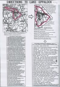
Document - Directions to Lake Eppalock with road descriptions and map
... The dam was built by the State Rivers and Water Supply Commission of Victoria. The dam wall height is 45 metres (148 ft) and the main embankment is 1,041 metres (3,415 ft) long. ...The dam was built by the State Rivers and Water Supply Commission of Victoria. The dam wall height is 45 metres (148 ft) and the main embankment is 1,041 metres (3,415 ft) long. ...John Perry Collection. Laminated copy of 'Directions to Lake Eppalock'. Gives directions in relationship of Lake Eppalock to Bendigo, Kyneton and Heathcote. Undated. Gives basic descriptions of bridges on lakebed, ford crossings on lakebed and inundated dwellings on lakebed. The dam was built by the State Rivers and Water Supply Commission of Victoria. The dam wall height is 45 metres (148 ft) and the main embankment is 1,041 metres (3,415 ft) long. At 100% capacity the dam wall was designed to hold back 304,651 megalitres (6.7014×10¹⁰ imp gal; 8.0480×10¹⁰ US gal) of water. The surface area of Lake Eppalock is 3,011 hectares (7,440 acres) and the catchment area is 2,124 square kilometres (820 sq mi). The controlled spillway is capable of discharging 8,040 cubic metres per second (284,000 cu ft/s). Lake Eppalock supplies both stock and domestic water to the Campaspe irrigation district. It also serves as a water supply to Bendigo and Heathcote and, in more recent times, Ballarat. The lake is a major attraction for those engaging in watersports, with a number of tourist parks and accommodation facilities available. Permissible activities on the lake include high-speed boating, water skiing, sailing, canoeing, fishing and swimming. The lake's water levels were low for approximately eight years between 2002 and 2010 during a prolonged drought, which restricted the amount of recreational activity until rainfall in the latter half of 2010 returned the lake to 100 percent capacity. Built between 1961 and 1964, Lake Eppalock remains the only water storage on the Campaspe River system.water, dam, directions, eppalock -
 Bendigo Historical Society Inc.
Map - Map of Lake Eppalock shoreline when empty
... The dam was built by the State Rivers and Water Supply Commission of Victoria. The dam wall height is 45 metres (148 ft) and the main embankment is 1,041 metres (3,415 ft) long. ...The dam was built by the State Rivers and Water Supply Commission of Victoria. The dam wall height is 45 metres (148 ft) and the main embankment is 1,041 metres (3,415 ft) long. ...John Perry Collection. Laminated copy of map detailing Lake Eppalock shoreline when empty. Circa 1951. Has colored highlighter lines following roads leading to lake shoreline and various inundated old roads and tracks on lakebed. The dam was built by the State Rivers and Water Supply Commission of Victoria. The dam wall height is 45 metres (148 ft) and the main embankment is 1,041 metres (3,415 ft) long. At 100% capacity the dam wall was designed to hold back 304,651 megalitres (6.7014×10¹⁰ imp gal; 8.0480×10¹⁰ US gal) of water. The surface area of Lake Eppalock is 3,011 hectares (7,440 acres) and the catchment area is 2,124 square kilometres (820 sq mi). The controlled spillway is capable of discharging 8,040 cubic metres per second (284,000 cu ft/s). Lake Eppalock supplies both stock and domestic water to the Campaspe irrigation district. It also serves as a water supply to Bendigo and Heathcote and, in more recent times, Ballarat. The lake is a major attraction for those engaging in watersports, with a number of tourist parks and accommodation facilities available. Permissible activities on the lake include high-speed boating, water skiing, sailing, canoeing, fishing and swimming. The lake's water levels were low for approximately eight years between 2002 and 2010 during a prolonged drought, which restricted the amount of recreational activity until rainfall in the latter half of 2010 returned the lake to 100 percent capacity. Built between 1961 and 1964, Lake Eppalock remains the only water storage on the Campaspe River system.map, eppalock, reservoir, lake, water -
 Bendigo Historical Society Inc.
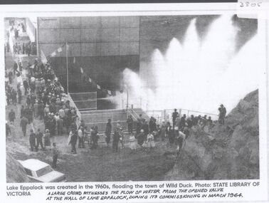
Document - Black and white laminated photo of flow of water from Lake Eppalock. 1964
... The dam was built by the State Rivers and Water Supply Commission of Victoria. The dam wall height is 45 metres (148 ft) and the main embankment is 1,041 metres (3,415 ft) long. ...The dam was built by the State Rivers and Water Supply Commission of Victoria. The dam wall height is 45 metres (148 ft) and the main embankment is 1,041 metres (3,415 ft) long. ...John Perry Collection. Laminated copy of photo of crowd watching flow of water from the opened valve at the wall of Lake Eppalock during its commissioning. March, 1964. Lake Eppalock was created by flooding to town of Wild Duck. The dam was built by the State Rivers and Water Supply Commission of Victoria. The dam wall height is 45 metres (148 ft) and the main embankment is 1,041 metres (3,415 ft) long. At 100% capacity the dam wall was designed to hold back 304,651 megalitres (6.7014×10¹⁰ imp gal; 8.0480×10¹⁰ US gal) of water. The surface area of Lake Eppalock is 3,011 hectares (7,440 acres) and the catchment area is 2,124 square kilometres (820 sq mi). The controlled spillway is capable of discharging 8,040 cubic metres per second (284,000 cu ft/s). Lake Eppalock supplies both stock and domestic water to the Campaspe irrigation district. It also serves as a water supply to Bendigo and Heathcote and, in more recent times, Ballarat. The lake is a major attraction for those engaging in watersports, with a number of tourist parks and accommodation facilities available. Permissible activities on the lake include high-speed boating, water skiing, sailing, canoeing, fishing and swimming. The lake's water levels were low for approximately eight years between 2002 and 2010 during a prolonged drought, which restricted the amount of recreational activity until rainfall in the latter half of 2010 returned the lake to 100 percent capacity. Built between 1961 and 1964, Lake Eppalock remains the only water storage on the Campaspe River system.water, dam, reservoir, eppalock, wild duck -
 Kiewa Valley Historical Society
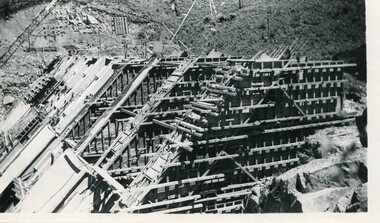
Photo - Junction Dam, September 1941
... Kiewa Valley Historical Society Mount Beauty Information Centre 31 Bogong High Plains Rd Mt Beauty high-country Junction Dam was part of the Hydro Electric Scheme during the 1940's State Electricity Commission of Victoria construction of the Kiewa Hydro Electric Scheme Junction Dam SECV Bogong Black & white photo of Junction Dam construction Photo - Junction Dam ...Junction Dam was part of the Hydro Electric Scheme during the 1940'sState Electricity Commission of Victoria construction of the Kiewa Hydro Electric SchemeBlack & white photo of Junction Dam constructionjunction dam, secv, bogong -
 Kiewa Valley Historical Society
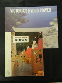
Booklets - Kiewa Hydro Electric Scheme, 1. "Power From Kiewa" and 2. "Victoria's Hydro Power", 1. Made in July 1968 and 2. Made in Aug. 1985
... victoria's hydro electric power; kiewa; mckay creek power station; clover power station; west kiewa power station 1. Colored soft cover with photo of McKay Creek Power Station on the front and Mt Beauty township on the back. Published by the SECV 2. Colored soft cover with Rocky Valley Dam ...1. The State Electricity Commission of Victoria built the Kiewa Hydro Electric Scheme from the 1930's to the 1960's. This booklet was to inform visitors and to promote tourism. 2. The State Electricity Commission built several hydro power stations from 1928 - 1981. This booklet names each with a summary and explanation.The State Electricity Commission of Victoria built the Kiewa Hydro Electric Scheme establishing infrastructure such as the Bogong and Mt Beauty townships and the opportunity for tourism in the area.1. Colored soft cover with photo of McKay Creek Power Station on the front and Mt Beauty township on the back. Published by the SECV 2. Colored soft cover with Rocky Valley Dam on the front and inserted photo of a stream and snow on the back. Published by the SEC.state electricity commission of victoria; kiewa hydro electric scheme; victoria's hydro electric power; kiewa; mckay creek power station; clover power station; west kiewa power station -
 Kiewa Valley Historical Society
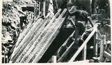
Photo - Junction Dam, December 1941
... Kiewa Valley Historical Society Mount Beauty Information Centre 31 Bogong High Plains Rd Mt Beauty high-country Junction Dam was part of the Hydro Electricity Scheme during the 1940's State Electricity Commission of Victoria (S.E.C.V.) construction of the Kiewa Hydro Electric Scheme Junction Dam Bogong SECV Black and white photograph of Junction Dam formwork construction Photo - Junction Dam ...Junction Dam was part of the Hydro Electricity Scheme during the 1940'sState Electricity Commission of Victoria (S.E.C.V.) construction of the Kiewa Hydro Electric SchemeBlack and white photograph of Junction Dam formwork constructionjunction dam, bogong, secv