Showing 383 items matching "dandenong creek"
-
 Whitehorse Historical Society Inc.
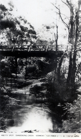
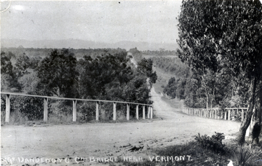
Photograph, Pretty Spot Dandenong Creek Vermont, C.1925
... Pretty Spot Dandenong Creek Vermont...dandenong creek.... Dandenong Creek. Vermont. Published by G.B. Carter 4793' of bridge... Mitcham melbourne dandenong creek vermont Black and white photo ...Black and white photo of a postcard entitled 'Pretty Spot. Dandenong Creek. Vermont. Published by G.B. Carter 4793' of bridge over Dandenong Creek, Vermontdandenong creek, vermont -
 Whitehorse Historical Society Inc.
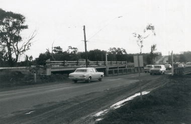
Photograph, Bridge in Burwood Road crossing Dandenong Creek, 1/06/1969 12:00:00 AM
... Bridge in Burwood Road crossing Dandenong Creek...dandenong creek...Black and white photo of bridge across Dandenong Creek... Mitcham melbourne burwood road dandenong creek Black and white ...Black and white photo of bridge across Dandenong Creek in Burwood Roadburwood road, dandenong creek -
 Whitehorse Historical Society Inc.
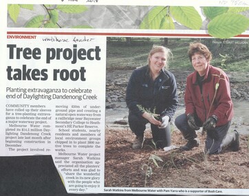
Article, Daylighting Dandenong Creek, 2018
... Daylighting Dandenong Creek...dandenong creek... Dandenong Creek project which involved removing 830m of underground... Dandenong Creek project which involved removing 830m of underground ...Melbourne Water completed its $14.5 million Daylighting Dandenong Creek project which involved removing 830m of underground pipe.Melbourne Water completed its $14.5 million Daylighting Dandenong Creek project which involved removing 830m of underground pipe. Members of the local community engaged to tree planting the area.Melbourne Water completed its $14.5 million Daylighting Dandenong Creek project which involved removing 830m of underground pipe. melbourne water, bush care, heathmont, dandenong creek -
 Ringwood and District Historical Society
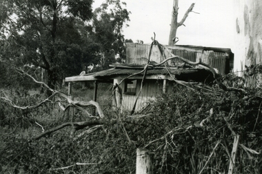
Photograph-B&W, Wantirna Road Shack next to Dandenong Creek on East Side of Wantirna Road (near the bridge), 6/07/1989
... Wantirna Road Shack next to Dandenong Creek on East Side of...Wantirna Road Shack next to Dandenong Creek on East Side...A shack next to Dandenong Creek / East side of Wantirna... Road Ringwood North melbourne A shack next to Dandenong Creek ...Wantirna Road Shack next to Dandenong Creek on East Side of Wantirna Road (near the bridge). Has been there many years - maybe 40 and it is still there (18.9.1989). (Note this is NOT part of Hill's dairy but was in the same series of photographs so kept together).A shack next to Dandenong Creek / East side of Wantirna Road / Has been there many years - maybe 40 / It is still there (18.9.89) -
 Whitehorse Historical Society Inc.
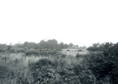
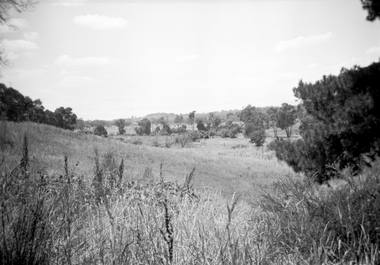
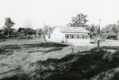
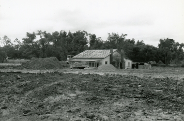
Photograph - B/W Photograph, Area North of Burwood Road near Dandenong Creek. For subdivision, 1971
... Area North of Burwood Road near Dandenong Creek. For... Dandenong Creek,... of Burwood Road near Dandenong Creek, Area North of Burwood Road near ...Black and White Photo of Area North of Burwood Road near Dandenong Creek,dandenong, burwwd road -
 Whitehorse Historical Society Inc.
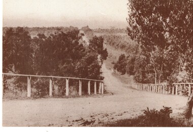
Photograph - Black and white photograph, Boronia Road, Vermont
... dandenong creek...Boronia Road Vermont approaching Dandenong Creek....Black and white photo of Boronia Road approaching Dandenong... Mitcham melbourne Boronia Road Vermont approaching Dandenong Creek ...Boronia Road Vermont approaching Dandenong Creek.Black and white photo of Boronia Road approaching Dandenong Creek, Vermontboronia road vermont, dandenong creek -
 Ringwood and District Historical Society
Envelope, Packet: Dandenong Creek Committee - notes re DVA, Consultation Committee. Correspondence. 1990s
... Packet: Dandenong Creek Committee - notes re DVA... Authority, Dandenong Creek Community Consultative Committee... handwritten notes Dandenong Valley Authority, Dandenong Creek ...16 pages typed and some handwritten notes Dandenong Valley Authority, Dandenong Creek Community Consultative Committee -
 Whitehorse Historical Society Inc.
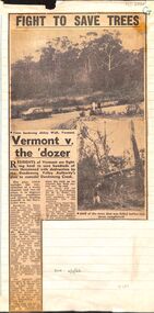
Article, Fight to save trees: Vermont v. the dozer, 1966
... Dandenong Creek...Dandenong Valley Authority's plan to remodel Dandenong... Dandenong Creek... Dandenong Creek. Vermont Dandenong Creek Dandenong Valley Authority ...Residents of Vermont are fighting to stop the destruction of trees .Residents of Vermont are fighting to stop the destruction of trees owing to the Dandenong Valley Authority's plan to remodel Dandenong CreekResidents of Vermont are fighting to stop the destruction of trees .vermont, dandenong creek, dandenong valley authority, abbey walk, vermont, larkman, barry, terry, w. g., mann, j. n. -
 Ringwood and District Historical Society
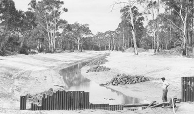
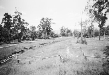
Photograph, New bridge over Dandenong Creek Wantirna Road Ringwood, being built and creek lined, 1970
... New bridge over Dandenong Creek Wantirna Road Ringwood...Written on back of photograph, "New bridge over Dandenong..., "New bridge over Dandenong Creek Wantirna Road being built ...Written on back of photograph, "New bridge over Dandenong Creek Wantirna Road being built and creek lined, 1970." -
 Ringwood and District Historical Society
Photograph, Looking east along Dandenong Creek from very end of Heatherdale Road, Vermont South, January 1979
... Looking east along Dandenong Creek from very end of... along Dandenong Creek from very end of Heatherdale Road."... Dandenong Creek from very end of Heatherdale Road." Looking east ...Written on back of photograph, "Jan. 79. Looking east along Dandenong Creek from very end of Heatherdale Road." -
 Ringwood and District Historical Society
Photograph, Series of 4 photos from Wantirna Rd Bridge over Dandenong Creek and Gold Course. Ringwood January 1979
... Series of 4 photos from Wantirna Rd Bridge over Dandenong.... bridge over Dandenong Creek -" 2674-1 / SS0357a: "looking east.... bridge over Dandenong Creek -" 2674-1 / SS0357a: "looking east ...4 Black and White photographs. Written on back of photographs - all prefixed "Jan '79. :Standing on top of concrete pole at end of handrail - Wantirna Rd. bridge over Dandenong Creek -" 2674-1 / SS0357a: "looking east along creek." 2674-2 / SS0357b: "looking north-east." 2674-3 / SS0357c: "looking north." (along Wantirna Road) 2674-4 / SS0357d: "looking west over gold club." -
Whitehorse Historical Society Inc.
Map, Burwood Highway, c1970
... Dandenong Creek... to Dandenong Creek, Vermont South.... Mitcham melbourne Dandenong Creek Morack Road Vermont South ...Enlarged aerial photo of area South of Burwood Highway to Dandenong Creek, Vermont South.Enlarged aerial photo of area South of Burwood Highway to Dandenong Creek, Vermont South.Enlarged aerial photo of area South of Burwood Highway to Dandenong Creek, Vermont South.dandenong creek, morack road, vermont south, burwood highway, vermont south, aerial photographs -
 Ringwood and District Historical Society
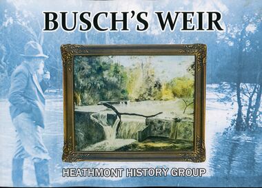
Book, PenFolk Publishing, Busch's Weir, 2019
... One of several Dandenong Creek marker posts inscriptions...A private weir on Dandenong Creek Bayswater and Heathmont... Dandenong Creek program. We particularly acknowledge... Road Ringwood North melbourne One of several Dandenong Creek ...One of several Dandenong Creek marker posts inscriptions: "Busch's Weir was located at this section of the creek between 1930s to 1960s. In the 1930s, German migrant Hermann Otto Busch and his wife Dorothea moved to Bayswater and opened the Waldheim Farm Guest House. Busch built a concrete weir to create a popular swimming and fishing destination. The weir was a thriving attraction until the 1960s. Although little remains, it is fondly remembered by the Heathmont community. City dwellers would retreat to the guesthouse and wander down to Dandenong Creek to enjoy a weekend in the 'country'. Busch's guest house, tea rooms, and weir attracted locals and tourists alike."A private weir on Dandenong Creek Bayswater and Heathmont, 1930s-1967. Landscape layout soft covered book by Heathmont History Group (Ringwood & District Historical Society.Front cover image: A 1956 painting by Hermann Busch of his weir. The publication of this book has been made possible by a financial grant from Melbourne Water, as part of the Enhancing Our Dandenong Creek program. We particularly acknowledge the encouragement and support of Sarah Watkins, Senior Planning Engineer, MW. -
 Whitehorse Historical Society Inc.
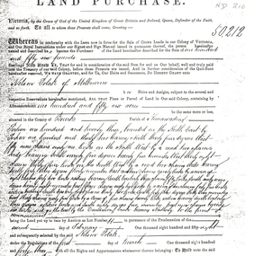
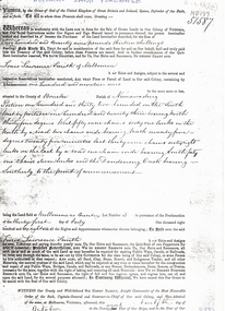
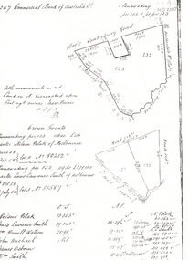
Legal record - Land Title, Land Purchase, 2/02/1858
... dandenong creek... to Dandenong Creek.... Mitcham melbourne polak nelson dandenong creek land sales ...Photocopy of agreement for land purchase by auction held on 2 February 1858.Photocopy of agreement for land purchase by auction held on 2 February 1858. Purchase by Nelson Polak of land adjacent to Dandenong Creek.Photocopy of agreement for land purchase by auction held on 2 February 1858. polak, nelson, dandenong creek, land sales -
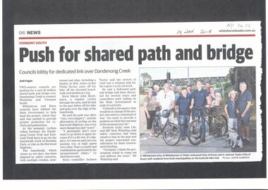 Whitehorse Historical Society Inc.
Article, Shared Path And Bridge, 2018
... dandenong creek... Government to help fund a shared path and bridge over Dandenong Creek... Mitcham melbourne dandenong creek vermont wantirna city ...Whitehorse and Knox councils are lobbying the State Government to help fund a shared path and bridge over Dandenong Creek to connect Wantirna and Vermont South.dandenong creek, vermont, wantirna, city of whitehorse, vicroads, bridges, cycling, pedestrian overpass -
 Ringwood and District Historical Society
Photograph, Wantirna road, Ringwood, last house on East side before Dandenong Creek on 20th May 1989, 1989
... Dandenong Creek on 20th May 1989..., Ringwood, last house on East side before Dandenong Creek on 20th ...Digital photograph -
 Ringwood and District Historical Society
Photograph, East side of Wantirna road between Taurus Restaurant and Dandenong Creek. The land has been raised level with fill, 1989
... Dandenong Creek. The land has been raised level with fill. ... road between Taurus Restaurant and Dandenong Creek. The land ...Digital photographA week after the photo was taken, the house was gone. In the 1950s, the council employed a man with horse and cart to chip and clean the prefabricated gutters. He lived in this house. -
 City of Greater Geelong
Watercolour, P Luton, Dandenong Creek
... Dandenong Creek...-and-the-bellarine-peninsula Dandenong Creek Watercolour P Luton ... -
 Whitehorse Historical Society Inc.
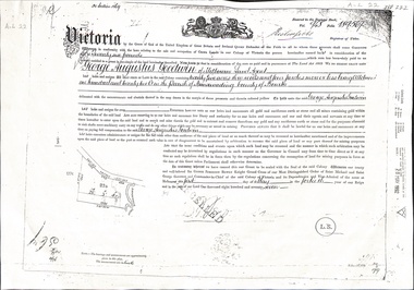
Document - Land Title, Certificate of Title, 01/05/1877
... dandenong creek... issued in 1877 for land adjacent to Dandenong Creek. Also copies...Whitehorse Historical Society Inc. 2-10 Deep Creek Road ...Certificate of Title issued to George Augustus Goodwin issued in 1877 for land adjacent to Dandenong Creek. Also copies of mortgages and eventual transfer to Annie Goodwingoodwin, george augustus, edwards, annie, dandenong creek, land settlement -
 Whitehorse Historical Society Inc.
Postcard, Historic Postcard - Set 2 no 5 - Boronia Road, c1920
... Dandenong Creek... Road, Vermont approaching Dandenong Creek, Vermont in the 1920s... Mitcham melbourne Dandenong Creek Vermont Nunawading Historical ...Black and white historic postcard (Set 2 No 5 ) Boronia Road, Vermont approaching Dandenong Creek, Vermont in the 1920s. Photo supplied by Nunawading Historical Societydandenong creek, vermont, nunawading historical society, boronia road, vermont, nunawading library & information service -
 Whitehorse Historical Society Inc.
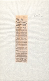
Newspaper - Article, Plan for Dandenong Valley park under way, 1/06/1992
... dandenong creek...Development of park along Dandenong Creek from Knox... Mitcham melbourne dandenong creek melbourne water floyd jeff ...Development of park along Dandenong Creek from Knox and Nunawading to Rowville and Mulgrave featuring wetlands, billabongs, cycling and walking tracks, bushland, picnic facilities and wildlife.dandenong creek, melbourne water, floyd, jeff, dandenong valley metropolitan park, chesterfield, chris, parks and reserves -
 Whitehorse Historical Society Inc.
Document - Land Title, Land purchase, 31/07/1858
... dandenong creek... July 1858. The land is adjacent to Dandenong Creek. Records... Mitcham melbourne dandenong creek smith l l dr william gallien ...Record of land purchase by Louis Laurence Smith dated 31 July 1858. The land is adjacent to Dandenong Creek. Records of the transfer of the land in June 1895 are included. Photocopies.dandenong creek, smith, l l dr, william, gallien, jacque jean, speary, catherine, langdon, harry joseph, foster, john, youngman, edward, simmons, morris, mayfield, william george, marion, land sales -
 Whitehorse Historical Society Inc.
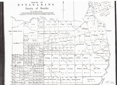
Document, Plan of Parish of Nunawading, 01/05/1864
... dandenong creek..., 1864 showing boundaries of Koonung, Mullum Mullum and Dandenong... dandenong creek Copy of plan of Parish of Nunawading Copy of plan ...Copy of plan of Parish of NunawadingCopy of plan of Parish of Nunawading, County of Bourke, lithographed at the Office of Lands and Survey, Melbourne, 13th May, 1864 showing boundaries of Koonung, Mullum Mullum and Dandenong Creeks.Copy of plan of Parish of Nunawadingland subdivision, parish of nunawading, county of bourke, elgars special survey, koonung creek, mullum mullum creek, dandenong creek -
 Whitehorse Historical Society Inc.
Legal record - Land Title, Crown grant, 1858
... dandenong creek... Boronia Road) and the Dandenong Creek.... vermont boronia road dandenong creek heatherdale road land sales ...Commercial Bank of Australia record of Crown Grants of land to Nelson Polak and Louis Laurence Smith in 1858.Commercial Bank of Australia record of Crown Grants of land to Nelson Polak and Louis Laurence Smith in 1858. The land is between Canterbury Road, Heatherdale Road, 'Scoresby Road' (now Boronia Road) and the Dandenong Creek.Commercial Bank of Australia record of Crown Grants of land to Nelson Polak and Louis Laurence Smith in 1858. polak, nelson, smith, l l dr, canterbury road, vermont, boronia road, dandenong creek, heatherdale road, land sales -
 Chelsea & District Historical Society Inc
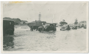
Photograph - Chelsea Flood December 1934, Point Nepean Road (Nepean Highway)
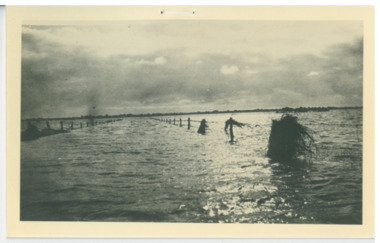
... Dandenong Creek..., when the Dandenong Creek and Patterson River broke their banks...., when the Dandenong Creek and Patterson River broke their banks ...In December 1934, 700 houses were inundated with water, when the Dandenong Creek and Patterson River broke their banks.Black and white photo of flood waters across Point Nepean Road (now Nepean Highway). Cars and trucks are driving through the water.flood, chelsea, dandenong creek, nepean highway, point nepean road -
 Chelsea & District Historical Society Inc
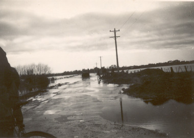
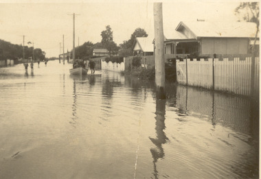
Photograph - Chelsea Flood December 1934, Wells Road, Chelsea
... Dandenong Creek..., when the Dandenong Creek and Patterson River broke their banks...., when the Dandenong Creek and Patterson River broke their banks ...In December 1934, 700 houses were inundated with water, when the Dandenong Creek and Patterson River broke their banks.Three Black and white photo of flood waters across Wells Road, Chelsea. A SEC truck can be see travelling down Wells Road in photo one and two, with people viewing the flooded street.flood, chelsea, dandenong creek, nepean highway, point nepean road -
 Chelsea & District Historical Society Inc
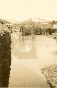
Photograph - Chelsea Flood December 1934, Carrum Hotel, Nepean Highway
... Dandenong Creek..., when the Dandenong Creek and Patterson River broke their banks...., when the Dandenong Creek and Patterson River broke their banks ...In December 1934, 700 houses were inundated with water, when the Dandenong Creek and Patterson River broke their banks.Black and white photo of flood waters in the garden of Carrum Hotel, showing an archway and in the background is a partially built building.flood, chelsea, dandenong creek, nepean highway, point nepean road, carrum hotel -
 Chelsea & District Historical Society Inc
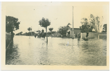
Photograph - Chelsea Flood December 1934, Wells Road and Thames Promenade
... Dandenong Creek..., when the Dandenong Creek and Patterson River broke their banks...., when the Dandenong Creek and Patterson River broke their banks ...In December 1934, 700 houses were inundated with water, when the Dandenong Creek and Patterson River broke their banks.Black and white photo taken from Wells Road looking down Thames Promenade, Chelsea.flood, chelsea, dandenong creek, fowler street, sherwood avenue -
 Chelsea & District Historical Society Inc
Photograph - Chelsea Flood December 1934
... Dandenong Creek..., when the Dandenong Creek and Patterson River broke their banks...., when the Dandenong Creek and Patterson River broke their banks ...In December 1934, 700 houses were inundated with water, when the Dandenong Creek and Patterson River broke their banks.Two Black and white photo of flood waters in Chelsea. flood, chelsea, dandenong creek, nepean highway, point nepean road -
 Chelsea & District Historical Society Inc
Photograph - Chelsea Flood December 1934, Argyle Avenue, Chelsea
... Dandenong Creek..., when the Dandenong Creek and Patterson River broke their banks...., when the Dandenong Creek and Patterson River broke their banks ...In December 1934, 700 houses were inundated with water, when the Dandenong Creek and Patterson River broke their banks.Black and white photo boys playing in the flood waters in Argyle Street, Chelsea, East of Fowler Street. Coming down the street is a horse pulling a cart with people on board, and a person on horse back following.flood, chelsea, dandenong creek, fowler street, argyle avenue, horse and cart