Showing 574 items matching dandenong creek
-
 Whitehorse Historical Society Inc.
Map, Dandenong Ranges Area, 1955
... Dandenong Creek.... Contours marked. Maps Vermont South Wantirna Dandenong Creek Sheet ...Sheet 13. Parts of Parishes: Nunawading, Mulgrave and Scoresby.Sheet 13. Parts of Parishes: Nunawading, Mulgrave and Scoresby. Includes area of Vermont South marked as proposed Township of Norwich. Scale 10 chains : 1 inch. Contours marked.Sheet 13. Parts of Parishes: Nunawading, Mulgrave and Scoresby. maps, vermont south, wantirna, dandenong creek -
 Whitehorse Historical Society Inc.
Article, Men of the Creeks, n.d
... dandenong creek... dandenong creek schwerkolt johann august bennett george william ...'Men of the Creeks' by R.V. Cottingham about early settlers in NunawadingPhotocopy 'Men of the Creeks' by R.V. Cottingham about early settlers in Nunawading, Boroondara, Bulleen and Mulgrave. 'Men of the Creeks' by R.V. Cottingham about early settlers in Nunawadinggardiners creek, damper creek, koonung creek, scotchman's creek, bushy creek, mullum mullum creek, dandenong creek, schwerkolt, johann august, bennett, george, william, wrighte, arundel, mcintyre, (mrs), duncan, o'leary, d, cleary, patrick -
 Whitehorse Historical Society Inc.
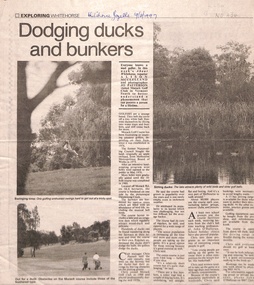
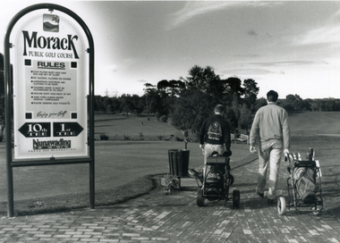
Newspaper - Article, Dodging ducks and bunkers, 19/03/1997
... dandenong creek... south dandenong creek morack golf course ...Morack Golf Course is located off Morack Road on 56.6 hectares. It is an eighteen hole golf course opened in 1976 as a nine hole course and extended in 1980.pannell, chris, o'halloran, john, morack road, vermont south, dandenong creek, morack golf course -
 Whitehorse Historical Society Inc.
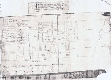
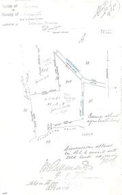
Document, South Riding
... dandenong creek... shire of nunawading. centre riding dandenong creek fulton dr ...Plan showing owners of land in the South Riding of the Shire of NunawadingPlan showing owners of land in the South Riding of the Shire of Nunawading 1888. South Boundary Road is now Highbury RoadPlan showing owners of land in the South Riding of the Shire of Nunawading land subdivision, shire of nunawading. centre riding, dandenong creek, fulton, dr, shire of nunawading. south riding, arundale, w, h. arnold & co. -
 Whitehorse Historical Society Inc.
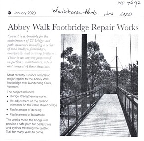
Article, Abbey Walk Footbridge Repairs, Jan 2020
... Dandenong Creek Vermont... Footpaths Bridges East Link City of Whitehorse Dandenong Creek ...Abbey Walk footbridge has been repaired.Abbey Walk footbridge has been repaired as part of the Whitehorse Council's regular maintenance program.Abbey Walk footbridge has been repaired. abbey walk vermont, footpaths, bridges, east link, city of whitehorse, dandenong creek vermont -
Whitehorse Historical Society Inc.
Map, Subdivision of Allotment 122a, 1972
... Dandenong Creek... Close Vermont South Moore Road Vermont South Dandenong Creek ...Subdivision of land along Livermore Close and Moore Road, Vermont South.Subdivision of land along Livermore Close and Moore Road, Vermont South. Original survey Rob Poole 1899. Stamp indicates 'Land on this plan is in proclaimed survey No 21. Survey Coordination Act 1940. As from 9 Aug 1972. Two maps in different scales.Subdivision of land along Livermore Close and Moore Road, Vermont South. land subdivision, livermore close, vermont south, moore road, vermont south, dandenong creek -
 Ringwood and District Historical Society
Document - Copy of Lands Department Field Notes - Ringwood, Victoria, Field Notes 76631 Surveyed in 1878
... , Dandenong Creek, Frank Miller, H.K. Kemps, Leech. Notations signed..., Dandenong Creek, Frank Miller, H.K. Kemps, Leech. Notations signed ...Foolscap size photocopy of survey map with handwritten notations. References include Canterbury Road, Bungalook Road, Dandenong Creek, Frank Miller, H.K. Kemps, Leech. Notations signed and dated January 1878 and May 1879. -
 Mt Dandenong & District Historical Society Inc.
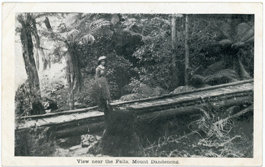
Photograph, View near the Falls, Mount Dandenong, early 1900s
... Mt Dandenong & District Historical Society Inc. 42 Falls ...Postcard showing a woman wearing a long dress and wide brimmed hat standing on a footbridge that crosses the Olinda Creek. Tree ferns and bushes are in the background. Taken early 1900s.On front of postcard: View near the Falls, Mount Dandenong. On back of post card: Mason, Firth & McCutcheon, Printers, Melbourne.mason, firth & mccutcheon, olinda falls, footbridge, bridge, mt dandenong, olinda creek -
 Ringwood and District Historical Society
Photograph, Boundary Photo across Dandenong Ck towards Ringwood (H E Parker Reserve). 1979
... . Looking across Dandenong Creek towards Ringwood (H.E. Parker... Dandenong Creek towards Ringwood (H.E. Parker Reserve) - ?? South ...Written on back of photograph, "Jan. 79 - boundary photo. Looking across Dandenong Creek towards Ringwood (H.E. Parker Reserve) - ?? South East corner of Ringwood. From children's playground end of Derwent (?) St." -
 Whitehorse Historical Society Inc.
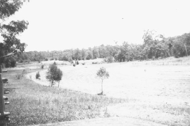
Photograph, Morack Public Golf Course, 1994
... and the Dandenong Creek.... and the Dandenong Creek. morack golf course ...Morak Golf Course opened to the public on Sat. 8th May, 1976. Comprising a 9-hole course it was sited north of Burwood Road (now Burwood Highway) and between Morak Road and the Dandenong Creek.Black and white photograph of the Morak Public Golf Course, Vermont South. Large sign on left and two golfers heading out on right. 1994morack golf course -
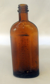 Orbost & District Historical Society
bottle, first half 20th century
... eucalyptus oil distillery, at Dandenong Creek in Victoria, followed..., at Dandenong Creek in Victoria, followed by others at Emerald, Menzies ...In 1852 Bosisto opened Australia’s first commercial eucalyptus oil distillery, at Dandenong Creek in Victoria, followed by others at Emerald, Menzies Creek and Macclesfield. and began selling the oil locally. Eucalyptus oil was used as a liniment. Bosisto's bottles were generally used for eucalyptus oil. the eucalyptus oil industry was a significant early Victorian industry. Bosisto's products were commoly used in households of the first half of the 20th century. A flat-sided, brown, glass bottle with a threaded top. It has rounded shoulders.in rectangle on back - THIS BOTTLE IS AND ALWAYS REMAINS THE PROPERTY OF J. BOSISTO & COMPANTY LTD on base - F1196 M and 239 vertically -
Glen Eira Historical Society
Article - St Peter's Catholic Church, Bentleigh East
... Boundary Road North Road Ormond Old Dandenong Road Mordialloc Creek ...Included In The File is A Newspaper Clipping From The Age Newspaper, Dated Sat 09/11/1974 On The Opening Written By Stuart Sayers. The Article Mentions A Brief History Of The Church & School Beginnings & The Opening Ceremony. There Are Two Copies Of The Living Harvest (One Without The Cover), The Book Gives A Detailed History Of St Peter's Catholic Church, Bentleigh East Written By W.T. Dobson And Published in 1974. From The First White Settlers, The Irish Exodus, And The Irish Catholic families, The School House And The History Of The Parish & Clergy Up To 1974.st peter's catholic church, niall patrick rev, emerald hill, bentleigh east, dobson w. t., yarra, moorabbin, heriot m. b., elsternwick, north road, quinn fred, bentleigh, centre road, kennedy james joseph, melbourne south, bignell road, kennedy market garden, oakleigh, st peter's parish, st james parish, the living harvest, catholic church, hibernian society, bavarian brass band, st peter's primary school, st james regional college, brighton catholic school, brighton – st kilda mission, niall patrick william fr, dendy henry, guiney john mr, king richard, king john, keys george, o’ shanassy john, keys robert, were jonathan b., o’ connell john fr, glass hugh mr, o’ farrell peter, brady peter, kennedy james, boland michael, mccormick francis, orrong road, little brighton, oakleigh, port phillip bay, east boundary road, north road, ormond, old dandenong road, mordialloc creek, moorabbin, springvale, no good damper road, kingstown, keysborough, bignell road, south road, heatherton, big brighton, gardenvale, elsternwick, brady road, jasper road, chesterville road, cochrane road, mcguinness road, h.a.c.b.s., school house, st patrick's church, brighton parish, denominational school, little brighton school, moorabbin catholic school, temporary chapel, st james regional college, sister of mercy, lanigans ball, east brighton public hall company ltd, east bentleigh hall, messrs. robert dunn & son, bavarian brass band, st joan of arc parish, east bentleigh parish, the sisters of our lady of sacred heart, the anchor club, mccormick cornelius, cochrane james, cochrane david, mcguinness margaret, cormick john, cahill james, quinn frederick, prendegast john patrick, naughton dennis, leary william, charlston john, carey matthew fr, gibbons patrick, kennedy joseph james, o’ sullivan tim fr, mckenna fred fr, casey william fr, browne joseph fr, crawford mal fr, hanrahan mr, gillon rose miss, sampson kate mrs, horan miss, coakley daniel fr, dillon kevin fr, whitehouse ray fr, mannix daniel dr, dobson william mr, gahan patrick, hallinan thomas, delaney john, fitzgerald patrick, st peter's catholic church -
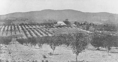 Ringwood and District Historical Society
Photograph, View from Canterbury Road/Balfour Avenue area overlooking Martell's orchard, Heathmont, 1929
... . Dandenong Creek just beyond house. Washusen Rd. on right". Written.... Dandenong Creek just beyond house. Washusen Rd. on right". Written ...Black and white photograph of orchard. House in middle range, mountains in background. Photograph appears to be reproduced from subdivisional brochure. Note inserted in sleeve reads, "It has been pointed out that the mountains are to the east and the view is looking south. This therefore is not a 'straight' photograph. House still exists in Eden Avenue at October, 1996".(3 copies).Typed below photograph, "Panoramic view taken on the estate". "View overlooking Martell's orchard, Heathmont, 1929". Taken from corner Canterbury Rd. and Balfour Ave. looking south. Dandenong Creek just beyond house. Washusen Rd. on right". Written on back of one of the copies, "Heathmont Station Estate 1922". "Station Street, Lisgoold St. Canterbury Rd. Vivienne Cres. Balfour Ave." -
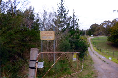 Whitehorse Historical Society Inc.
Photograph, Nethercote property, 2012
... was situated in Boronia Road near Dandenong Creek. Originally a flower... which was situated in Boronia Road near Dandenong Creek ...The land photographed is widely known as Nethercotes. In 1920 Arthur Nethercote, import agent, bought the land which was situated in Boronia Road near Dandenong Creek. Originally a flower farm, the Nethercotes became poultry farmers. The property contained a five-roomed weatherboard house which they called Weston Favell. Dated before 1883 (from newspapers found in the ceiling) it is the more dilapidated house photographed. The other house called Greenways was built for a son. Gerald Letts bought the property and when he died the Board of Works purchased the land, intending to use it as part of the proposed Healesville Freeway, meanwhile the property was leased to the Box Hill Institute's equine department. In 2013 the Board of Works announced that the freeway would not go ahead.Coloured photographs of the two houses and land at the Nethercote property, Vermont. Now owned by the board of Works and leased to the Box Hill Institute.nethercote property, vermont, board of works, proposed healesville freeway, box hill institute -
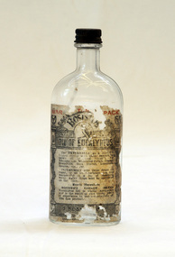 Orbost & District Historical Society
bottle, Probably WW11
... operations in a small, rudely constructed still at Dandenong Creek..., rudely constructed still at Dandenong Creek, Victoria, using ...Joseph Bosisto was a Yorkshireman who had qualified as a Pharmacist in Leeds and London. He arrived in Adelaide in 1848 at the age of 21. In 1851 he moved to Victoria in search of gold, but instead opened a pharmacy in Richmond, where he built a laboratory to investigate the chemical and medicinal properties of Australian plants. As a result of the collaboration with von Meuller the essential oil industry of Australia began in 1852, when Bosisto commenced operations in a small, rudely constructed still at Dandenong Creek, Victoria, using the leaves of a form of E. radiata (then known as E. amygdalina) which grew profusely in the district. Bosisto soon built other distilleries at Emerald, Menzies Creek and Macclesfield. World War II soldiers packed it in their mess kits to keep foot fungus in the tropics at bay. Small clear glass Eucalyptus Oil bottle with metal screw lid and large label on front.Front Label - War Time Pack Back - This bottle remains property of J Bosisto &Co Pty Ltd Richmond Victoria Bottom-F1196bottle eucalyptus-oil bosisto-joseph -
Ringwood and District Historical Society
Document, List of bushland reserves in Maroondah - early 2000
... is next to Dexter's, on the Dandenong Creek. Good luck, Helen Moss.... is next to Dexter's, on the Dandenong Creek. Good luck, Helen Moss. ...Typed document"Attached to List" Hand written note from Helen Moss to Gayle Abbe ( Archivist Ringwood Historical Society) "Here is some information on Dexters Bush and a report I prepared on the bushland reserves in Maroondah which mentions many of the relevant Ringwood reserves. There is also a copy of my phone list for reserves contacts. Roger Lord is listed - so is Anne Kaufman who knows the Angus Avenue/Ruthven Way area very well and may be able to suggest some additions to your heritage list. It would also be worth talking to Eva about the Alexander's land, which is next to Dexter's, on the Dandenong Creek. Good luck, Helen Moss. -
 Ringwood and District Historical Society
Pamphlet, G.A. Green, Auction Sale Brochure - Garden Farms Estate, Ringwood, Victoria - 1919, 1919
... Dandenong Creek, to its southern boundary on the main Bayswater Road... of New Bridge over Dandenong Creek. (Image) On one ...Multi-fold brochure advertising public auction of one-acre, 2-acre, 5-acre and 8-acre allotments in Ringwood and Bayswater on Saturday 12th April, 1919. Brochure includes terms of sale, description of subdivision features and local facilities, and photographic images of the area.Subdivison includes Canterbury Road Heathmont, Armstrong Road Heathmont, Armstrong Road Bayswater, Bungalook Road Heathmont, Bungalook Road Bayswater, and Orchard Road Bayswater. Road shown as Bayswater Road to Bayswater became Mountain Highway Bayswater. Vendor: H.E.B.Armstrong, Auctioneers: Coghill & Haughton, 79 Swanston Street Melbourne, Telephone Central 2793, in conjunction with J.B. McAlpin, Ringwood, Opposite Station, Telephone Ringwood 7. (Map) Woodcock & McCormack, Civil Engineers Architects & Surveyors, 430 Little Collins Street, Melbourne, Phone 3241 Central. MOST OF THE MONEY COMES OUT OF THE LAND. And more money can be obtained from anb acre of fruit than from an acre of any other produce. But you do not have to grow fruit on Garden Farms Estate. You can go in for - Outer Suburban Home - Market Garden - Orchard - Pig Raising - Poultry Farm - Small Dairy Farm - Small Fruits - Floral Culture - Scent and Bee Farm - Or just for a Week-end Home. RINGWOOD - THE PLACE TO LIVE. The Beautiful Ringwood District has so many natural attractions, that half a Land Agent's work is done in just showing a prospective buyer round and about. Ringwood has a pull of its own that attracts folk, proved beyond doubt by its rapid development within the last decade (spite the war). First, it is high and healthy, picturesque and undulating, convenient of access, sufficiently close to the Metropolis for City and Business folk to live at Ringwood. Its development is solid, because most of its people are industrious husbandmen, real producers, who have turned idle hills into smiling gardens. These are the kind of real people to live amongst; ones who wear out their spades. The rapidly-developing town has excellent Stores, Trade and Repair Shops Churches, Banks, Telephone Exchange, Weekly General Market, Cool Stores, and good Private and State Schools, etc.; is Electrically lit, has Metropolitan Water Supply, and generally provides so that practically all shopping can be done locally. WHY RINGWOOD MUST GROW. Ringwood is a great centre and must be a greater. Two rapidly-developing railways junction here. The passengers from Ringwood Station cityward, in one year, number 250,000. Ringwood will be the terminus of the Outer Suburban Electric Eastern Railway. Its natural boundaries are the River Yarra on the North, Dandenong Creek on the South, the popular town of Croydon on the East, and the suburb of Mitcham on the West. This is a large territory that is steadily being converted from intense culture, and then it might be called (as regards its gardens) "The Devon Territory of Victoria." ARMSTRONG ROAD. This new road traverses Garden Farms Estate from its northern boundary on the main Canterbury Road, across Dandenong Creek, to its southern boundary on the main Bayswater Road, and will provide a long-desired additional link of communication between Bayswater and Ringwood. The 1-acre building sites on Bayswater Road are within 8 minutes' walk of the Bayswater Railway Station, and the Canterbury Road frontages are only 1-1/2 miles from Ringwood Station, and 1/2 mile from the Railway Station site of Canterbury Road; therefore, the whole Estate is easy of access and there should be a large demand for land so favourably placed. (Image) Cultivation Field - Potatoes on Lot 28 (Image) Picture of Bayswater Creek Flats. (Image) View from "Korumbeen" where Mr. Armstrong lived on Garden Farms Estate. Estate outlined in white ring. (Image) Site of New Bridge over Dandenong Creek. (Image) On one of the timbered lots adjoining railway. (Image) This Dandenong Creek traveres the Estate. (Image) Main Fern Tree Gully Line bisects the Estate. -
 Ringwood and District Historical Society
Pamphlet, Land Sale Brochure Titled Eureka Plan Book - Seven Delightful & Valuable Ringwood Estates - circa 1925
... of Creek Estate, Ringwood, includes Dandenong Creek, Wantirna Road..., Ringwood, includes Dandenong Creek, Wantirna Road and Gordon ...Twenty page land sale brochure including photographs, subdivision features and local facilities. Additional flyer with conditions of sale and prices for estate blocks.Seven delightful and valuable Ringwood Estates called Bestpart, Paradise, Hill Top, Greenwood, Creek, Station, and School Estates. These nestle amidst the hills and valleys of beautiful Ringwood district. Also Goodluck Estate at Clarinda. Pamphlet marked as being From Mr. Farmer, No. 5 Flinders Court, Melbourne. Phone 988, 989 Central, or 55 Ringwood after 7 p.m. Plan of Ringwood School Estate includes William Street (later Kendall Street), Greenwood Avenue, Alton Street and Locke Street. Plan of Bestpart Estate, Ringwood, includes Bedford Road, Wilana Street, Greenwood Avenue, Caroline Street, Henry Street and Haig Street. Plan of Ringwood Station Estate includes Pitt Street, Bedford Road, Greenwood Avenue, Station Street, William Street (later Kendall Street, James Street, Wantirna Road, Caroline Street, Henry Street, Ellison Street and Haig Street. Plan of Geenwood Estate, Ringwood, includes Prussian Road (later Geenwood Avenue). Plan of Paradise Estate, Ringwood, includes Canterbury Road, Dandenong Road (Wantirna Road), Luck Street and Paradise Road. Plan of Creek Estate, Ringwood, includes Dandenong Creek, Wantirna Road and Gordon Crescent. Plan of Hill Top Estate, Ringwood (later Heathmont area), includes Heathmont Railway Station, Heathmont Road, Balfour Avenue, Lilian Street, Edith Street, Edna Street and Great Ryrie Street. Plan of Goodluck Estate, Clarinda, includes Talbot Avenue, Good Street, Luck Street, and Centre Road in locality plan between Oakleigh and Clayton Railway Stations. -
 Marysville & District Historical Society
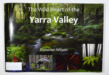
Book, The Wild Heart of the Yarra Valley, Unknown
A pictorial book of the flora, fauna, rivers, waterfalls and rainforest in the Upper Yarra ValleyPaperback. Front cover has a main photograph of a creek running through a forest. There is also four smaller photographs. They are of a Red Coral Fungi, a Superb Lyrebird, a night time view looking upwards in a grove of trees and a view of a Soft tree fern. The back cover has a photograph of a Superb Lyrebird.yarra valley, upper yarra valley, flora, fauna, photography, rivers, waterfalls, rainforest, nature, donovan wilson -
 Marysville & District Historical Society
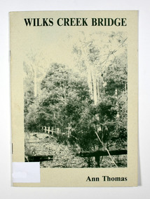
Book, Wilks Creek Bridge, 1993
A history of the Wilks Creek Bridge and its connection to the Yarra TrackPaperback. Front cover has an old photograph of the Wilks Creek Bridge.Dear Reader, The pen has only to select one of the many stages of building old Yarra Track,/ for a colorful story subject. The Track, first established in the early 1860's to/ serve goldseekers making their hazardous way to the rich Wood's Point goldfields,/ extended some 160km from Eltham - in Melbourne's northern region to Woods/ Point in the eastern ranges. I hope a glimmer of the excitement of those times comes through as I draw/ your attention to old Wilks Creek bridge and its picnic spot to be found 3.5km/ west of Marysville. Once part of Yarra Track and now superseded by a modern/ roadway alongside, the old bridge with its solid masonry walls either side of the/ cold, pure stream makes a pleasing scene for the visitor. With much pleasure/ I dedicate this narrative to Marysville and District Historical Society./ Ann Thomas Stamp of Marysville & District / Historical Society Inc / P.O. Box 22 / Marysville 3779wilks creek, marysville, yarra track, victoria, history, local history -
Marysville & District Historical Society
Flyer (item) - Information Flyer, Artworkz Tourism, Marysville-Meeting of the Waters (Marysville), Post 2009
A flyer that was produced as a guide to the Meeting of the Waters near Marysville in Victoria.A flyer that was produced as a guide to the Meeting of the Waters near Marysville in Victoria. The meeting of the Waters is where the two rivers, the Taggerty River and Whitehouse Creek combine. meeting of the waters, marysville, victoria, taggerty river, whitehouse creek -
Marysville & District Historical Society
Article (item) - Museum Victoria Australia Article, Museum Victoria Australia, Aboriginal Land, Unknown
A brief history of the Kulin clan in Victoria.A brief history of the Kulin clan in Victoria.kulin clan, great dividing range, yarra river, goulburn river, tonne-be-wong, toole-be-wong, donne-be-wong, mount riddell, ben cairn, donna buang, port phillip settlement, john batman, james dredge, port phillip protectorate for aborigines, duang wurrung, king parrot creek, acheron river, mitchellstown, william le souef, murchison, woi wurrung, boon wurrung, warrandyte, mordialloc, little river, william thomas, acheron station, mohican run, john green, mohican station, badger creek, healesville, coranderrk, black's spur, christmas bush, prostanthera lasianothos, geringdah -
Marysville & District Historical Society
Article (item) - Book extract, Gerald W. Noble, Extract from "The Red Gate"-a history of Alexandra, 1969
An extract from "The Red Gate" regarding the Kulin clan.An extract from "The Red Gate" regarding the Kulin clan.gerald w noble, the red gate, alexandra, kulin tribe, yarra river, ovens river, yauung-illam-baluk, mansfield, john cotton, port phillip, goulburn, lands commissioner lesouef, mining boom, ut creek, donald mckenzie, mohican station, acheron station -
Marysville & District Historical Society
Article (item) - Newspaper article, The Alexandra and Eildon Standard, Indigenous history in the shire after colonisation, 08-03-2017
A newspaper article regarding indigenous history in the Murrindindi Shire after colonisation of the region.A newspaper article regarding indigenous history in the Murrindindi Shire after colonisation of the region.Wednesday, March 8, 2017alexandra, kulin, taungurung, goulburn, woi wurrung, yarra, acheron river, little river, dandenong ranges, land board, aboriginal guardian, william thomas, aboriginal station, lands minister, acheron station, mohican run, rubicon river, cathedral mountain, john green, mohican station, upper yarra, yarra tribe, woori yallock, hoddles creek, yarra river, badger creek, healesville, coranderrk, christmas bush, prostanthera lasianthos, black's spur -
Marysville & District Historical Society
Article (item) - Book extract, Unknown
A book extract from an unknown publication.A book extract from an unknown publication.mohican station, board of land and works, acheron station, niagaroon station, r brough smyth, robert hickson, john green, goulburn district, wurunjeri, yarra river, rev r hamilton, illustrated australian news 25 august 1865, coranderrk, central board, woori yaloak, upper yarra, woori yaloak reserve, hoddles creek, woori yaloak creek -
Marysville & District Historical Society
Article (item) - Magazine Article, Coranderrk-A Station Never a Mission, Unknown
A magazine article on the history of Coranderrk based on a historical component of a survey of Coranderrk Station.A magazine article on the history of Coranderrk based on a historical component of a survey of Coranderrk Station.coranderrk, coranderrk station, dr marie hansen fels, healesville and district aboriginal community, john green, healesville, acheron river, mohican, native police corps, merri creek, closer settlement act, badger creek, hops, cattle, royal commission of 1877, board of enquiry 1881, lake tyers -
Marysville & District Historical Society
Document (item) - Gold Mine Prospectus, H.D. McKie, Prospectus of the New Golden Bower & Star Gold M.Co, 1896
A copy of the Prospectus of the New Golden Bower & Star Gold M.Co. near Marysville in Victoria.A copy of the Prospectus of the New Golden Bower & Star Gold M.Co. near Marysville in Victoria. The Golden Bower gold mine was a quartz reef mine. William Edward Chester discovered the Golden Secret gold vein which became part of the Golden Bower Mine at Chesterville near Donovans Creek on the Cumberland goldfield which he mined with George Locke until the late 1930s. new golden bower & star gold m.co., donovan's creek, nuggety gully creek, yarra track, marysville, victoria, share prospectus, upper yarra track, wood's point, victoria mount morgan gold mining co., british mount morgan mine, mr white, reefton turnoff, santa claus reef, bear's creek, mr r ely, bear's creek reef, big river, mr feely, new star reef, golden bower reef, a1 mining co, mr r m lee, locke's no.1 extended gold mining company, mr q dick -
Marysville & District Historical Society
Document (item) - Gold Mine Prospectus, Messrs Bruce & Robinson, Prospectus-Chester & Locke's Golden Secret Gold Mining Company, 1899
A copy of the prospectus for the Chester & Locke's Golden Secret Mining Company near Marysville in Victoria.A copy of the prospectus for the Chester & Locke's Golden Secret Mining Company near Marysville in Victoria. The Golden Bower gold mine was a quartz reef mine. William Edward Chester discovered the Golden Secret gold vein which became part of the Golden Bower Mine at Chesterville near Donovans Creek on the Cumberland goldfield which he mined with George Locke until the late 1930s. FOR PRIVATE CIRCULATIONshare prospectus, chester & locke's golden secret mining company, marysville, victoria, yarra track, upper yarra district, david newell, j.g. aikman, w.j. mountain, andrew barrie, gold mining, messrs w.p. jones and co., william chester, george locke, chesterville -
Marysville & District Historical Society
Document (item) - Letter, Andrew Kirwan mining-Wolfram & Gold at Cumberland River, 09-07-1981
A letter outlining the history of Andrew Kirwan who was a gold miner and road worker in Marysville in Victoria.A letter outlining the history of Andrew Kirwan who was a gold miner and road worker in Marysville in Victoria. Andrew Kirwan, along with his brothers, located and worked the Wolfram Mine at Wilkes Creek where they mined tungsten.andrew kirwan, marysville, victoria, cumberland valley, wolfram mine, wilkes creek, anderson and rowe sawmill, cumberland creek, golden bower gold mine, william chester, maria catherine kirwan, kirwan's reward, tungsten, cumberland river -
Marysville & District Historical Society
Document (Item) - Heritage Report, Biosis Research Pty Ltd, Heritage Report-Dismantling of Wilks Creek Brdige Deck Marysville, Unknown
A heritage report on the dismantiling of the Wilks Creek Bridge deck in Marysville in Victoria.A heritage report on the dismantiling of the Wilks Creek Bridge deck in Marysville in Victoria. The Wilks Creek Bridge is a former timber and bluestone road bridge on the Yarra Track, and is located just off the Black Spur route, between Narbethong and Marysville, Victoria, Australia. It was built in 1870 to the design of colonial Public Works Department engineer Clement Wilks as part of the construction of a new road to the Woods Point and Jordan Goldfields. Like many bridges of the period, it had a timber superstructure employing squared beams supported by struts and straining pieces, on cut bluestone abutments. The bridge was remodelled around 1900 by engineer John Monash of the famous bridge-engineering firm of Monash and Anderson. It was last used for heavy vehicular traffic in 1980 following the realignment of Marysville Road, and was left to decay until its demolishment in 2008. All timber traces of the bridge were destroyed in the 2009 Black Saturday fires. The handcrafted bluestone masonry wingwalls and abutments, especially shaped to receive timber struts, rate among the earliest of its kind surviving intact in Victoria.wilks creek bridge, yarra track, narbethong, marysville, victoria, clement wilks, wood's point goldfields, jordan goldfields, john monash, monash and anderson, 2009 black saturday bushfires