Showing 23 items matching "dandenong creek vermont"
-
 Whitehorse Historical Society Inc.
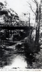
Photograph, Pretty Spot Dandenong Creek Vermont, C.1925
... Pretty Spot Dandenong Creek Vermont...dandenong creek...vermont...Black and white photo of a postcard entitled 'Pretty Spot. Dandenong Creek. Vermont. Published by G.B. Carter 4793' of bridge over Dandenong Creek, Vermont...Dandenong Creek. Vermont. Published by G.B. Carter 4793' of bridge over Dandenong Creek, Vermont Pretty Spot Dandenong Creek Vermont Photograph Photograph ...Black and white photo of a postcard entitled 'Pretty Spot. Dandenong Creek. Vermont. Published by G.B. Carter 4793' of bridge over Dandenong Creek, Vermontdandenong creek, vermont -
 Whitehorse Historical Society Inc.
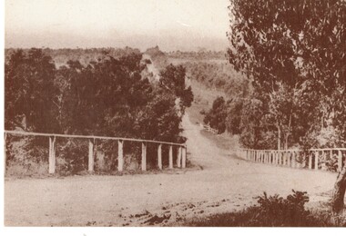
Postcard, Historic Postcard - Set 2 no 5 - Boronia Road, c1920
... Dandenong Creek...Vermont...Black and white historic postcard (Set 2 No 5 ) Boronia Road, Vermont approaching Dandenong Creek, Vermont in the 1920s. Photo supplied by Nunawading Historical Society...Whitehorse Historical Society Inc. 2-10 Deep Creek Road Mitcham melbourne Dandenong Creek Vermont Nunawading Historical Society Boronia Road Vermont Nunawading Library & Information Service Black and white historic postcard (Set 2 No 5 ) Boronia Road, Vermont approaching Dandenong Creek, Vermont in the 1920s. ...Black and white historic postcard (Set 2 No 5 ) Boronia Road, Vermont approaching Dandenong Creek, Vermont in the 1920s. Photo supplied by Nunawading Historical Societydandenong creek, vermont, nunawading historical society, boronia road, vermont, nunawading library & information service -
 Whitehorse Historical Society Inc.
Map, Burwood Highway, c1970
... Dandenong Creek...Morack Road...Vermont...Enlarged aerial photo of area South of Burwood Highway to Dandenong Creek, Vermont South....Whitehorse Historical Society Inc. 2-10 Deep Creek Road Mitcham melbourne Dandenong Creek Morack Road Vermont South Burwood Highway Vermont South Aerial photographs Enlarged aerial photo of area South of Burwood Highway to Dandenong Creek, Vermont South. ...Enlarged aerial photo of area South of Burwood Highway to Dandenong Creek, Vermont South.Enlarged aerial photo of area South of Burwood Highway to Dandenong Creek, Vermont South.Enlarged aerial photo of area South of Burwood Highway to Dandenong Creek, Vermont South.dandenong creek, morack road, vermont south, burwood highway, vermont south, aerial photographs -
 Whitehorse Historical Society Inc.
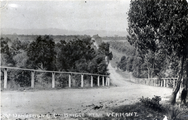
Photograph - Black and white photograph, Boronia Road, Vermont
... vermont...dandenong creek...Boronia Road Vermont approaching Dandenong Creek....Black and white photo of Boronia Road approaching Dandenong Creek, Vermont...Whitehorse Historical Society Inc. 2-10 Deep Creek Road Mitcham melbourne Boronia Road Vermont approaching Dandenong Creek. boronia road vermont dandenong creek Black and white photo of Boronia Road approaching Dandenong Creek, Vermont Boronia Road, Vermont Photograph Black and white photograph. ...Boronia Road Vermont approaching Dandenong Creek.Black and white photo of Boronia Road approaching Dandenong Creek, Vermontboronia road vermont, dandenong creek -
 Whitehorse Historical Society Inc.
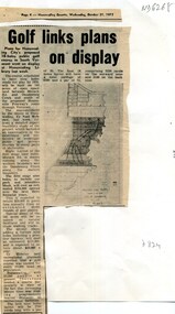
Article, Golf links plans on display, 1973
... Plans for the 145 acre South Vermont course between Morack Road and Dandenong Creek Vermont displayed at Nunawading Library...Creek Road Mitcham melbourne Displayed at Nunawading Library. Morack Golf Course South Vermont Plans for the 145 acre South Vermont course between Morack Road and Dandenong Creek Vermont Plans for the 145 acre South Vermont course between Morack Road and Dandenong Creek Vermont displayed at Nunawading Library Golf links plans on display Article Article ...Plans for the 145 acre South Vermont course between Morack Road and Dandenong Creek VermontPlans for the 145 acre South Vermont course between Morack Road and Dandenong Creek Vermont displayed at Nunawading LibraryPlans for the 145 acre South Vermont course between Morack Road and Dandenong Creek Vermontmorack golf course, south vermont -
Whitehorse Historical Society Inc.
Document, Nethercote Letter, 2010 & 2012
... Dandenong Creek...Vermont...Vale Road C 1920 and his obituary 26.3.2012. Dandenong Creek Vermont Nethercote Viv L.L. Vale Road Vermont Transcript of letter from Viv Nethercote 2010. ...Transcript of letter from Viv Nethercote 2010.Transcript of letter from Viv Nethercote 2010 in reference to an old photograph of L.L. Vale Road C 1920 and his obituary 26.3.2012.Transcript of letter from Viv Nethercote 2010.dandenong creek, vermont, nethercote, viv, l.l. vale road, vermont -
 Whitehorse Historical Society Inc.
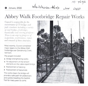
Article, Abbey Walk Footbridge Repairs, Jan 2020
... ...Dandenong Creek Vermont...Whitehorse Historical Society Inc. 2-10 Deep Creek Road Mitcham melbourne Part of the Whitehorse Council's regular maintenance program. Abbey Walk Vermont Footpaths Bridges East Link City of Whitehorse Dandenong Creek Vermont Abbey Walk footbridge has been repaired. ...Abbey Walk footbridge has been repaired.Abbey Walk footbridge has been repaired as part of the Whitehorse Council's regular maintenance program.Abbey Walk footbridge has been repaired. abbey walk vermont, footpaths, bridges, east link, city of whitehorse, dandenong creek vermont -
 Whitehorse Historical Society Inc.
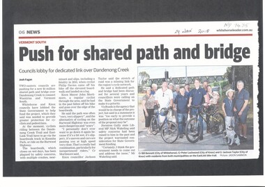
Article, Shared Path And Bridge, 2018
... dandenong creek...vermont...Whitehorse and Knox councils are lobbying the State Government to help fund a shared path and bridge over Dandenong Creek to connect Wantirna and Vermont South....Whitehorse Historical Society Inc. 2-10 Deep Creek Road Mitcham melbourne dandenong creek vermont wantirna city of whitehorse vicroads bridges cycling pedestrian overpass Whitehorse and Knox councils are lobbying the State Government to help fund a shared path and bridge over Dandenong Creek to connect Wantirna and Vermont South. ...Whitehorse and Knox councils are lobbying the State Government to help fund a shared path and bridge over Dandenong Creek to connect Wantirna and Vermont South.dandenong creek, vermont, wantirna, city of whitehorse, vicroads, bridges, cycling, pedestrian overpass -
 Eltham District Historical Society Inc
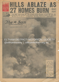
Newspaper - Newspaper articles, Sun News-Pictorial, Hills Ablaze As 27 Homes Burn, The Sun News-Pictorial, Monday, January 15, p1, 1962
... Creek...Scouts...Australian Logging Co....A.W. Larkins...Heathmont...Vermont...R. Pearson...Mike Ryan...Vic Parker...C.G. Wilson...Hillside Farm...Clive Brewer...Ron Anderson...Mrs Anderson...Mt Dandenong...Tom Fielding Collection Victorian Bushfires - 1962 Victorian Bushfires – 1962 Dandenongs The Basin Yarra Glen Healesville Montrose Chum Creek Scouts Australian Logging Co. A.W. Larkins Heathmont Vermont R. ...Various news articles pertaining to the January 1962 Victorian bushfires in the Dandenong and Healesville districts. • Hills Ablaze As 27 Homes Burn; Night Fight, p1 (Illust.) • Yarra Glen, Healesville Saved; Fire into main street, p2 (Illust.) • Flare-up at Montrose, p2 • 20 scouts flee as fire sweeps camp, p2 • Gaol for fires today …, p2 • Timber lost, p2 • Heathmont home lost, but others saved, p2 • The desperate fight, p3 (Illust.) • Rubbish fire got away; Basin blaze, p3 • Panorama of destruction, p3 • Fire Captain Killed; 7 road deaths at week-end, p5 (Illust.) • Heartbreak, ruin as … Fire Sweeps the Hills, pp18-19 .(Illust.) • Tea; they made it for the fire fighters, pp18-19 (Illust.) tom fielding collection, victorian bushfires - 1962, victorian bushfires – 1962, dandenongs, the basin, yarra glen, healesville, montrose, chum creek, scouts, australian logging co., a.w. larkins, heathmont, vermont, r. pearson, mike ryan, vic parker, c.g. wilson, hillside farm, clive brewer, ron anderson, mrs anderson, mt dandenong, healesville rural fire brigade, malcolm barber, yarra flats, r. bicknell, ferny creek, blue hills gues house, heatherset road, sassafras, olinda, presbyterian manse, john gorie, janice gorie, lynette gorie, jacky wilson, patricia cortie -
 Ringwood and District Historical Society
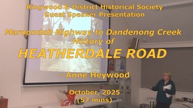
Mixed media - Video, RDHS Meeting Presentation - "Maroondah Highway to Dandenong Creek via Heatherdale Road" - Anne Heywood
... Vermont. The area has been a mixture of agriculture, then light industry, and is disected by rail and power lines, yet joins two major east-west arterial roads - Canterbury Road and Maroondah Highway. Digitised video (2.94GB). Duration: 57 minutes. Recorded October, 2025 (Video is available for viewing at Ringwood & District Historical Society Archives by appointment) RDHS Meeting Presentation - "Maroondah Highway to Dandenong Creek via Heatherdale Road" - Anne Heywood Mixed media Video ...Digitised video (2.94GB). Duration: 57 minutes. Recorded October, 2025 (Video is available for viewing at Ringwood & District Historical Society Archives by appointment)For this presentation, prominent researcher and RDHS member Anne Heywood has been busy uncovering the history of this relatively unknown area of Ringwood. It is the convergence of four suburbs - Mitcham, Ringwood, Heathmont and Vermont. The area has been a mixture of agriculture, then light industry, and is disected by rail and power lines, yet joins two major east-west arterial roads - Canterbury Road and Maroondah Highway. -
 Ringwood and District Historical Society
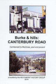
Book, Burke & Hills: Canterbury Road Camberwell to Montrose, by Heathmont History Group - 2014
... Vermont, Heathmont and at its other end, Montrose, by then in the foothills of the Dandenongs. Grand homes and churches at one end, major and minor shopping centres along the 25km, factories now where farms were, big box stores, fast food outlets, train stations, resrvoir, traffic, residential stretches, modern apartment blocks, parklands, child-minding centres, sporting ovals, a sewage farm, hotels, quarries, commercial developments, plant nurseries, a golf course, bridges, memorials, Asian food shops, telecommunication towers, bushland, creeks, crossroads, traffic lights, mansions, orchards, swamps ... ...Vermont, Heathmont and at its other end, Montrose, by then in the foothills of the Dandenongs. Grand homes and churches at one end, major and minor shopping centres along the 25km, factories now where farms were, big box stores, fast food outlets, train stations, resrvoir, traffic, residential stretches, modern apartment blocks, parklands, child-minding centres, sporting ovals, a sewage farm, hotels, quarries, commercial developments, plant nurseries, a golf course, bridges, memorials, Asian food shops, telecommunication towers, bushland, creeks, crossroads, traffic lights, mansions, orchards, swamps ... ...Soft cover book of 40 pages with spiral wire spine. Compilation of images and descriptive timeline of the geology, geography and European settlement history of Canterbury Road.Soon after beginning at Burke Road Camberwell, Canterbury Road moves into the gentle hills of Canterbury, then on to Surrey Hills, Box Hill and Forest Hill. Further along past these three "hills" come three "monts" - Vermont, Heathmont and at its other end, Montrose, by then in the foothills of the Dandenongs. Grand homes and churches at one end, major and minor shopping centres along the 25km, factories now where farms were, big box stores, fast food outlets, train stations, resrvoir, traffic, residential stretches, modern apartment blocks, parklands, child-minding centres, sporting ovals, a sewage farm, hotels, quarries, commercial developments, plant nurseries, a golf course, bridges, memorials, Asian food shops, telecommunication towers, bushland, creeks, crossroads, traffic lights, mansions, orchards, swamps ... Delaneys Road, renamed Canterbury Road after a 19th century Victorian Governor, is a fascinating study in land use and history as suburban Melbourne has continually diversified and pushed outwards. Compiled by Heathmont History Group, Rita James, Les Prato, Betty Colbert, Jeff Leipold, Gerry Robinson (convenor). -
 Ringwood and District Historical Society
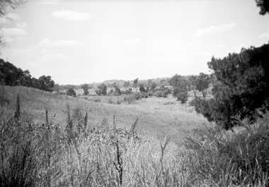
Photograph, Looking east along Dandenong Creek from very end of Heatherdale Road, Vermont South, January 1979
... Looking east along Dandenong Creek from very end of Heatherdale Road, Vermont South, January 1979...Looking east along Dandenong Creek from very end of Heatherdale Road." Looking east along Dandenong Creek from very end of Heatherdale Road, Vermont South, January 1979 Photograph ...Written on back of photograph, "Jan. 79. Looking east along Dandenong Creek from very end of Heatherdale Road." -
 Whitehorse Historical Society Inc.
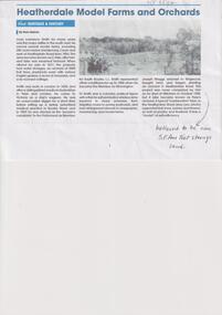
Article, Haines, Russ, Heatherdale Model Farms and Orchards
... Vermont. He listed it for sale in 1877 and the property had water storages, 2,000 fruit trees, paddocks sown with various English grasses, 6 acres of vineyards and a 6 room cottage. Smith Louis Lawrence Maggs Joseph Pyko's Orchard Haines Russ Dr. Louis Lawrence Smith owned several model farms in Victoria including 280 acres below Dandenong Creek ...Dr. Louis Lawrence Smith owned several model farms in Victoria including 280 acres below Dandenong Creek and west of Heatherdale Road from 1856non-fictionDr. Louis Lawrence Smith owned several model farms in Victoria including 280 acres below Dandenong Creek and west of Heatherdale Road from 1856smith louis lawrence, maggs joseph, pyko's orchard, haines russ -
 Whitehorse Historical Society Inc.
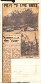
Article, Fight to save trees: Vermont v. the dozer, 1966
... Vermont...Dandenong Creek...Residents of Vermont are fighting to stop the destruction of trees owing to the Dandenong Valley Authority's plan to remodel Dandenong Creek...Whitehorse Historical Society Inc. 2-10 Deep Creek Road Mitcham melbourne Dandenong Valley Authority's plan to remodel Dandenong Creek. Vermont ...Residents of Vermont are fighting to stop the destruction of trees .Residents of Vermont are fighting to stop the destruction of trees owing to the Dandenong Valley Authority's plan to remodel Dandenong CreekResidents of Vermont are fighting to stop the destruction of trees .vermont, dandenong creek, dandenong valley authority, abbey walk, vermont, larkman, barry, terry, w. g., mann, j. n. -
Whitehorse Historical Society Inc.
Pamphlet, Morack Public Golf Course, c1985
... Creek Road Mitcham melbourne Its history is outlined and its proposed development. Course maintenance and watering systems are described. The verso is a detailed plan of the course. Morack Golf Course Dandenong Valley Metropolitan Park Pamphlet describing the Morack Public Golf Course in Vermont South. ...Pamphlet describing the Morack Public Golf Course in Vermont South.Pamphlet describing the Morack Public Golf Course in Vermont South. Its history is outlined and its proposed development. Course maintenance and watering systems are described. The verso is a detailed plan of the course.Pamphlet describing the Morack Public Golf Course in Vermont South. morack golf course, dandenong valley metropolitan park -
Whitehorse Historical Society Inc.
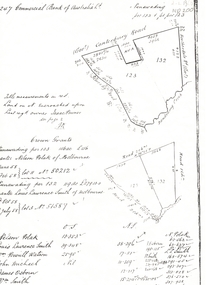
Map, Subdivision of Allotment 122a, 1972
... Vermont South...Dandenong Creek...Creek Road Mitcham melbourne Original survey Rob Poole 1899. Stamp indicates 'Land on this plan is in proclaimed survey No 21. Survey Coordination Act 1940. As from 9 Aug 1972. Two maps in different scales. Land Subdivision Livermore Close Vermont South Moore Road Vermont South Dandenong ...Subdivision of land along Livermore Close and Moore Road, Vermont South.Subdivision of land along Livermore Close and Moore Road, Vermont South. Original survey Rob Poole 1899. Stamp indicates 'Land on this plan is in proclaimed survey No 21. Survey Coordination Act 1940. As from 9 Aug 1972. Two maps in different scales.Subdivision of land along Livermore Close and Moore Road, Vermont South. land subdivision, livermore close, vermont south, moore road, vermont south, dandenong creek -
 Whitehorse Historical Society Inc.
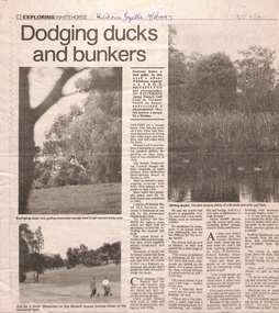
Newspaper - Article, Dodging ducks and bunkers, 19/03/1997
... vermont south...dandenong creek...Whitehorse Historical Society Inc. 2-10 Deep Creek Road Mitcham melbourne pannell chris o'halloran john morack road vermont south dandenong creek morack golf course Morack Golf Course is located off Morack Road on 56.6 hectares. ...Morack Golf Course is located off Morack Road on 56.6 hectares. It is an eighteen hole golf course opened in 1976 as a nine hole course and extended in 1980.pannell, chris, o'halloran, john, morack road, vermont south, dandenong creek, morack golf course -
Whitehorse Historical Society Inc.
Map, Dandenong Ranges Area, 1955
... Vermont South...Wantirna...Dandenong Creek...Whitehorse Historical Society Inc. 2-10 Deep Creek Road Mitcham melbourne Includes area of Vermont South marked as proposed Township of Norwich. Scale 10 chains : 1 inch. Contours marked. Maps Vermont South Wantirna Dandenong ...Sheet 13. Parts of Parishes: Nunawading, Mulgrave and Scoresby.Sheet 13. Parts of Parishes: Nunawading, Mulgrave and Scoresby. Includes area of Vermont South marked as proposed Township of Norwich. Scale 10 chains : 1 inch. Contours marked.Sheet 13. Parts of Parishes: Nunawading, Mulgrave and Scoresby. maps, vermont south, wantirna, dandenong creek -
Whitehorse Historical Society Inc.
Document, Fruitgrowing in early Vermont
... vermont...dandenong creek...Handwritten information about fruit growing in Vermont from about 1880 to 1945. the area bounded by Boronia Road, the Dandenong Creek and Morack Road was a grant by Queen Victoria to an old soldier named Moore. ...Whitehorse Historical Society Inc. 2-10 Deep Creek Road Mitcham melbourne orchards boronia road vermont dandenong creek moore isaac morack road vermont south Handwritten information about fruit growing in Vermont from about 1880 to 1945. the area bounded by Boronia Road, the Dandenong Creek and Morack Road was a grant by Queen Victoria to an old soldier named Moore. ...Handwritten information about fruit growing in Vermont from about 1880 to 1945. the area bounded by Boronia Road, the Dandenong Creek and Morack Road was a grant by Queen Victoria to an old soldier named Moore.Handwritten information about fruit growing in Vermont from about 1880 to 1945. the area bounded by Boronia Road, the Dandenong Creek and Morack Road was a grant by Queen Victoria to an old soldier named Moore. This area was subdivided about 1880. A few fruit trees planted. Later Williams Pears and Jonathan Apples were found to be best to grow. The peak of growing fruit was 1930 - 39 and steadily declined after this due to labour shortages and lack of markets during 1939 - 1945.Handwritten information about fruit growing in Vermont from about 1880 to 1945. the area bounded by Boronia Road, the Dandenong Creek and Morack Road was a grant by Queen Victoria to an old soldier named Moore. orchards, boronia road, vermont, dandenong creek, moore, isaac, morack road, vermont south -
Whitehorse Historical Society Inc.
Map, Dandenong Ranges area. Sheet 7, c1957
... Creek Road Mitcham melbourne maps mitcham vermont ringwood heathmont Detailed map covering area from Mitcham and Vermont to Ringwood and Heathmont. Detailed map covering area from Mitcham and Vermont to Ringwood and Heathmont. Shows streets, block boundaries, buildings, railway and creeks. Note says prepared from State Aerial Survey, April 1954 and Cadastrial Survey information July 1956. Dandenong ...Detailed map covering area from Mitcham and Vermont to Ringwood and Heathmont.Detailed map covering area from Mitcham and Vermont to Ringwood and Heathmont. Shows streets, block boundaries, buildings, railway and creeks. Note says prepared from State Aerial Survey, April 1954 and Cadastrial Survey information July 1956.Detailed map covering area from Mitcham and Vermont to Ringwood and Heathmont. maps, mitcham, vermont, ringwood, heathmont -
 Whitehorse Historical Society Inc.
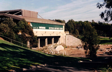
Photograph, Waste Transfer Station
... The waste centre is situated next to Dandenong Creek and opposite Mahoneys Road Vermont South. Land fill was used until the 1980's when Whitehorse joined the "least Waste" program....Situated in Vermont South near Dandenong Creek...Situated in Vermont South near Dandenong Creek Waste Transfer Station Photograph Photograph ...The waste centre is situated next to Dandenong Creek and opposite Mahoneys Road Vermont South. Land fill was used until the 1980's when Whitehorse joined the "least Waste" program.Coloured photograph of the City of Whitehorse Recycling & Waste Centre, rear view. Situated in Vermont South near Dandenong Creekwaste transfer station, whitehorse transfer station, waste, recycling -
 Whitehorse Historical Society Inc.
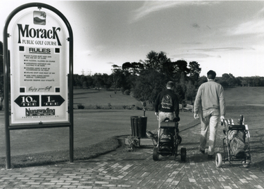
Photograph, Morack Public Golf Course, 1994
... Comprising a 9-hole course it was sited north of Burwood Road (now Burwood Highway) and between Morak Road and the Dandenong Creek. morack golf course Black and white photograph of the Morak Public Golf Course, Vermont South. ...Morak Golf Course opened to the public on Sat. 8th May, 1976. Comprising a 9-hole course it was sited north of Burwood Road (now Burwood Highway) and between Morak Road and the Dandenong Creek.Black and white photograph of the Morak Public Golf Course, Vermont South. Large sign on left and two golfers heading out on right. 1994morack golf course -
 Whitehorse Historical Society Inc.
Legal record - Land Title, Crown grant, 1858
... vermont...boronia road...dandenong creek...polak nelson smith l l dr canterbury road vermont boronia road dandenong creek heatherdale road land sales Commercial Bank of Australia record of Crown Grants of land to Nelson Polak and Louis Laurence Smith in 1858. ...Commercial Bank of Australia record of Crown Grants of land to Nelson Polak and Louis Laurence Smith in 1858.Commercial Bank of Australia record of Crown Grants of land to Nelson Polak and Louis Laurence Smith in 1858. The land is between Canterbury Road, Heatherdale Road, 'Scoresby Road' (now Boronia Road) and the Dandenong Creek.Commercial Bank of Australia record of Crown Grants of land to Nelson Polak and Louis Laurence Smith in 1858. polak, nelson, smith, l l dr, canterbury road, vermont, boronia road, dandenong creek, heatherdale road, land sales