Showing 19 items matching "dead reckoning"
-
 Moorabbin Air Museum
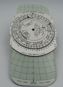
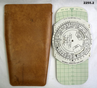
Instrument (item) - Kane Dead Reckoning Computer MK-6B, With Pouch
... Kane Dead Reckoning Computer MK-6B, With Pouch....Kane Dead Reckoning Computer MK-6B, With Pouch....Kane Dead Reckoning Computer MK-6B, with pouch, used in aerial navigation....Kane Dead Reckoning Computer MK-6B, With Pouch. Instrument Kane Dead Reckoning Computer MK-6B, With Pouch. ... -
 Moorabbin Air Museum
Manual (Item) - US Navy Air Navigation Training Course Part 3, Dead Reckoning, Air Navigation - Part Three: Dead Reckoning and Lines of Position
... US Navy Air Navigation Training Course Part 3, Dead Reckoning...Air Navigation - Part Three: Dead Reckoning and Lines of Position...Moorabbin Air Museum Moorabbin Airport 12 First Street Moorabbin melbourne Brown soft-cover manual with illustration of plane and globe on the front Air Navigation - Part Three: Dead Reckoning and Lines of Position Manual US Navy Air Navigation Training Course Part 3, Dead Reckoning ... -
Moorabbin Air Museum
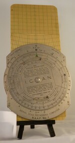
Tool (item) - Aerial Dead Reckoning Computer RAAF Mk.1
... Aerial Dead Reckoning Computer RAAF Mk.1...Aerial Dead Reckoning Computer RAAF Mk.1...Moorabbin Air Museum Moorabbin Airport 12 First Street Moorabbin melbourne Aerial Dead Reckoning Computer RAAF Mk.1 Tool Aerial Dead Reckoning Computer RAAF Mk.1 ... -
 Moorabbin Air Museum
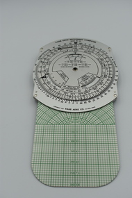
Instrument (item) - Kane Dead Reckoning Computer MK-6B, With Pouch
... Kane Dead Reckoning Computer MK-6B, With Pouch....Kane Dead Reckoning Computer MK-6B, With Pouch....Moorabbin Air Museum Moorabbin Airport 12 First Street Moorabbin melbourne Kane Dead Reckoning Computer MK-6B, With Pouch. Instrument Kane Dead Reckoning Computer MK-6B, With Pouch. ... -
Moorabbin Air Museum
Book - Navigation, The Observer's Book on Dead Reckoning Navigation
... The Observer's Book on Dead Reckoning Navigation...Moorabbin Air Museum Moorabbin Airport 12 First Street Moorabbin melbourne Navigation General remarks Position lines Air plotting Relative velocity Radius of action Overview of all forms of dead reckoning navigation, circa 1940 The Observer's Book on Dead Reckoning Navigation Book Navigation ...Overview of all forms of dead reckoning navigation, circa 1940non-fictionOverview of all forms of dead reckoning navigation, circa 1940general remarks, position lines, air plotting, relative velocity, radius of action -
Moorabbin Air Museum
Booklet - Navigation, Dead Reckoning Navigation
... Dead Reckoning Navigation...Moorabbin Air Museum Moorabbin Airport 12 First Street Moorabbin melbourne Navigation Methods of navigation Navigational terms Magnetic compass errors Very brief overview on dead reckoning navigation, circa 1965 Dead Reckoning Navigation Booklet Navigation ...Very brief overview on dead reckoning navigation, circa 1965non-fictionVery brief overview on dead reckoning navigation, circa 1965methods of navigation, navigational terms, magnetic compass errors -
Frankston RSL Sub Branch
Computer, Navigation
... Aerial Dead Reckoning Computer in leather pouch. This device was used as a navigational aid by aircraft pilots and crew. ...The leather pouch has the following printed on the outside "W&G Aerial Dead Reckoning Computer R.A.A.F. Mk 1"...Frankston RSL Sub Branch 183 Cranbourne Road Frankston mornington-peninsula The leather pouch has the following printed on the outside "W&G Aerial Dead Reckoning Computer R.A.A.F. Mk 1" Aerial Dead Reckoning Computer in leather pouch. ...Aerial Dead Reckoning Computer in leather pouch. This device was used as a navigational aid by aircraft pilots and crew. W&G Aerial Dead Reckoning Computer R.A.A.F. Mk 1 Made in Australia by White & Gillespie Front Scale: Distance Naut Miles, True Air Speed (Time Min, Hrs, Density Altitude, Air Temp ) Back Scale: Wind Correction Angle( True Heading ) The leather pouch has the following printed on the outside "W&G Aerial Dead Reckoning Computer R.A.A.F. Mk 1" -
 Flagstaff Hill Maritime Museum and Village
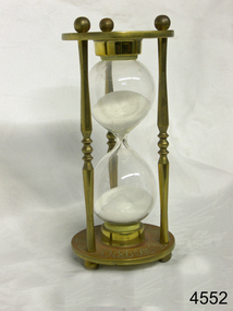
Instrument - Hourglass
... ...dead reckoning...The sandglasses at sea were gradually replaced in the late 1700’s to early 1800’s by the more accurate chronometers (marine clocks) when they became reliable instruments. DEAD RECKONING (or Deduced Reckoning) Dead reckoning is the term used to describe the method of calculating the ship’s position from its speed and direction, used in early maritime travel, mostly in European waters. ...The sandglasses at sea were gradually replaced in the late 1700’s to early 1800’s by the more accurate chronometers (marine clocks) when they became reliable instruments. DEAD RECKONING (or Deduced Reckoning) Dead reckoning is the term used to describe the method of calculating the ship’s position from its speed and direction, used in early maritime travel, mostly in European waters. ...An hourglass or sandglass is an instrument for measuring a defined time and can be used perpetually by simply turning it over immediately the top bulb empties. The clear blown glass is shaped into two equal sized bulbs with a narrow passage in the centre and contains uniform sized sand or glass particles in the lower bulb. The width of the neck regulates the constant flow of the particles. The glass is held in a stand with top and bottom of equal shape and size. Hourglasses can measure an infinite variety of time by gauging the size of the particles, the shape and size of the bulbs and the size of the passage between the bulbs, thus measuring hours or minutes or even seconds. Generally an hourglass sits between discs of wood at the ends, which are joined by long wooden spindles between the ends and tightened by screw caps. The length of time can be adjusted by adding or removing sand particles. The use of the marine sandglass (or hourglass) has been recorded in the 14th century in European shipping. A one minute sandglass was used in conjunction with the ship’s log for ‘dead reckoning’, (see below) that is, for measuring the ship’s speed through the water. They were also used to regulate ringing the ship’s timetable; for example a 4 hour sandglass was used for the length of the sailors’ watch, and a half hour timer for taking of readings for the ship’s log; the ship’s bell would be rung every half hour. It was usually the role of the cabin boy to watch and turn the sandglasses over at the exact time of them emptying their upper chambers and to ring the ship’s bell. Hourglasses have been used historically for many hundreds of years. Some have been used for timing church sermons, in cooking, in industry and at sea. Even today they are used for measuring the cooking time of eggs and timing a player’s turn in games such as Boggle and Pictionary. The sandglasses at sea were gradually replaced in the late 1700’s to early 1800’s by the more accurate chronometers (marine clocks) when they became reliable instruments. DEAD RECKONING (or Deduced Reckoning) Dead reckoning is the term used to describe the method of calculating the ship’s position from its speed and direction, used in early maritime travel, mostly in European waters. Both the (1) speed and the (2) direction of travel were recorded on a Traverse Board at half-hourly intervals during a helmsman’s watch of 4 hours. The navigator would record the readings in his ship’s log, plot them on his navigational chart and give his updated course directions to the next helmsman on watch, along with the cleared Traverse Board. This was a very approximate, but none-the-less helpful, method of navigation. The wooden Traverse Board was a simple pegboard with a diagram of a compass with eight peg holes along the radius to each of the compass points, plus a grid with ascending half hours in the left column and increasing ship’s speed in knots in a row across the column headings, with a peg hole in each of the intersecting cells. A number of wooden pegs were attached to strings on the board. By placing one peg consecutively in the direction’s radius hole, starting from the centre, and the speed holes when the half hourly reading was taken, a picture of speed and direction for the whole 4 hour watch was created. (1) To measure the ship’s speed a one minute hourglass timer was usually used to measure the ship’s speed through the water and help to calculate its longitude. A rope, with knots at regular standard intervals and a weight such as a log at the end, would be thrown overboard at the stern of the ship. At the same time the hourglass would be turned over and a seaman would start counting the number of knots on the rope that passed freely through his hands as the ship travelled. When the timer ran out the counting would be stopped. A timer of one minute (one-sixtieth of an hour), knots spaced one-sixtieth of a nautical mile apart, and simple arithmetic easily gave the speed of the ship in nautical miles per hour ("knots"). This would be recorded every half hour. The speed could however be inaccurate to the travel being affected by ocean currents and wind. (2) To calculate the ship’s direction a compass sighting would be recorded each half hour.Marine hourglasses or sandglasses were used from around the 14th to 19th century during the time of sailing ships. This hourglass is representative of that era, which is during the time of the colonisation of Australia. Hourglass or sandglass; an instrument used to measure time. Two equal sized clear glass bulbs joined with a narrow passage between them, containing equal sized particles of sand grains in lower bulb. Glass sits in a brass collar at each end, in a frame comprising 3 decorative brass columns or posts, each attached top and bottom, using round screw-on feet, to round brass discs. Disc have Roman numerals for the numbers 1 - 12 pressed into their inner surfaces and hieroglyphics on the outer surfaces. Roman numerals on inner surface of discs " I II III IV V VI VII VIII IX X XI XII " Hieroglyphics impressed on outer surface of discsflagstaff hill, warrnambool, shipwrecked coast, flagstaff hill maritime museum, maritime museum, shipwreck coast, flagstaff hill maritime village, great ocean road, horology, hourglass, hour glass, sandglass, sand glass, timing instrument, dead reckoning, deduced reckoning, finding latitude at sea, sandglass with hieroglyphics and roman numerals, hourglass with hieroglyphics and roman numerals, brass hourglass -
 Flagstaff Hill Maritime Museum and Village
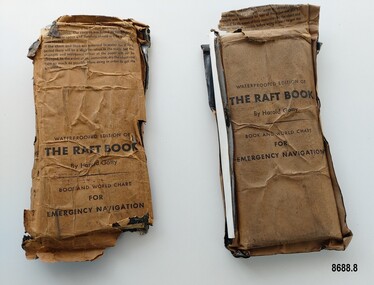
Booklet - Book and World Chart for Emergency Navigation, George Grady Press, The Raft Book, 1943
... ...Dead reckoning...He worked with several record breaking pilots including Ann Morrow Lindbergh (who went on to serve as a navigator for her husband Charles Lindbergh), helped Wiley Post break the world record circumnavigating the Earth, invented a new method of "dead reckoning" that revolutionised the ability to fly safely through cloudy conditions without drifting off course and famously navigated a small plane (whilst trying to cross the Pacific) over 1900 km through fog (with no radio) and using only his dead reckoning techniques, back to their starting point in Japan after they developed fuel problems. ...He worked with several record breaking pilots including Ann Morrow Lindbergh (who went on to serve as a navigator for her husband Charles Lindbergh), helped Wiley Post break the world record circumnavigating the Earth, invented a new method of "dead reckoning" that revolutionised the ability to fly safely through cloudy conditions without drifting off course and famously navigated a small plane (whilst trying to cross the Pacific) over 1900 km through fog (with no radio) and using only his dead reckoning techniques, back to their starting point in Japan after they developed fuel problems. ...Harold Gatty was born on January 5th, 1903 in Campbell Town, Tasmania. He was a navigator and aviation pioneer. He began his career learning navigation at the age of 14 as a midshipman at the Royal Australian Naval College but withdrew after three years and became an apprenticed ship's officer with the Patrick Steamship Company of Sydney. After W. W. 1 he joined the Australian Merchant Navy where he learned the constellations while standing night watch and became an expert in celestial navigation while serving on many ships sailing between Australia and California. In 1927 he moved to California and opened a navigation school and also a laboratory repairing navigational equipment. At this time he became very interested in air navigation and was aware of the limitations of existing methods and instruments for aerial navigation. He began researching ways of improving aerial navigation. Two early inventions of his were his air sextant and a ground speed and drift indicator which formed the basis of the automatic pilot which later came to be standard equipment on most aircraft. He worked with several record breaking pilots including Ann Morrow Lindbergh (who went on to serve as a navigator for her husband Charles Lindbergh), helped Wiley Post break the world record circumnavigating the Earth, invented a new method of "dead reckoning" that revolutionised the ability to fly safely through cloudy conditions without drifting off course and famously navigated a small plane (whilst trying to cross the Pacific) over 1900 km through fog (with no radio) and using only his dead reckoning techniques, back to their starting point in Japan after they developed fuel problems. In 1932 Gatty received the Distinguished Flying Cross from President Hoover. In 1934 Gatty formed the South Seas Commercial Company with Donald Douglas with the aim to deliver air services to the islands of the South Pacific. The Company was sold to Pan Am but he continued to work for them. In 1935 he went on a sailing expedition investigating several small islands in the South Pacific and was briefly marooned on Baker Island. He was able to use his extensive knowledge of seabird habits to save the crew. He was also very interested in the ability of the Polynesians to navigate using the stars. During the Second World War Gatty was given the honorary rank of Group Captain in the Royal Australian Air Force (RAAF) and worked for the U. S. Army Air Forces (USAAF) in the South Pacific. In 1943 he moved to Washington where he developed a survival book (The Raft Book) specifically for boat crews or air crews flying over the Pacific to help them survive and navigate their life rafts in remote areas of the ocean. The original book was 152 pages long however a condensed version was made which consisted of a 64 page booklet, combined map and star chart and calendar strip enclosed in a waterproof slipcase, to be placed in life rafts for emergency use. The booklet included navigational advice and ideas such as ocean currents, estimation of distance, using a compass, measurement of angles, recognising and steering by the stars, land indications from sea birds, migration of sea birds and insects, sounds from the land, the scent of the land and ocean currents and the colour of the sea etc. After W.W.2 Gatty moved to Fiji and formed Fiji Airways (which later became Air Pacific). Harold Gatty died in August 1957.The two copies of "The Raft Book" are significant as they are a written summary of the many methods of sea navigation (both modern and historical) that existed in the 1940's. They are also a record of Harold Gatty, who played a significant role in the development of modern day aerial navigation using his understanding of different sea navigational techniques.Two rectangular brown packets with waterproof coverings (oiled paper) titled "The Raft Book" by Harold Gatty. Each packet contains a folded 64 page paper booklet with detailed instructions for navigating a small craft in open seas, a folded chart (with a map of the world and oceans, well known constellations, latitude and longitude charts, Greenwich time and a scale for string lengths and Harp scale) and a long folded paper calendar strip.Front of package - "WATERPROOFED EDITION OF/ THE RAFT BOOK / By Harold Gatty / BOOK AND WORLD CHART / FOR / EMERGENCY NAVIGATION / To open envelope tear along above line. If the envelope is used again fold the flap to keep contents dry. 1. This envelope contains a book, chart and tape for emergency navigation. The contents are folded to take up the least possible space and therefore should not be removed until needed. 2. if the chart and tape are immersed in water for a long period, there will be a slight variation in the scale but the strength and resistence to tear of the paper will not be changed. In the event of long immersion, dry the chart and tape as much as possible before using in order to in order to get the greatest accuracy in scale. Front of booklet - THE RAFT BOOK / LORE OF THE SEA AND SKY /By Harold Gatty IMPORTANT FOR YOUR SECURITY/Upon abandoning ship you may have to be your own navigator. Take the following pre/cautions for your own safety:/ Carry a good type of pocket watch / keep it wound and have it running on Greenwich (England) / Time, which you can get from the navigating officer. / Keep track of the date at Greenwich; and on a 24-hour basis, / know whether the time is, say, 6 hours (6 A.M.) showing on / your watch, or 18 hours (6P.M.) Greenwich. / PROECT YOUR WATCH. GET A RUBBER SACK FOR IT (OBTAIN FROM PHARMACIST) AND KEEP IT DRY / KEEP A PENCIL IN YOUR POCKET/ POSITION OF SHIP WHEN ABANDONED PRINTED IN UNITED STATES OF AMERICA GEORGE GRADY PRESS, NEW YORK/COPYRIGHT, 1943, BY HAROLD AND FENNA GATTYflagstaff hill maritime museum and village, shipwreck coast, warrnambool, the raft book, harold gatty, book and world chart for emergency navigation, ww 2, ww ii, navigation, air navigation, aerial navigation, lindbergh, wiley post, dead reckoning, south seas commercial company, u.s. army airforce, usaaf, survival book, life rafts, sea navigation, emergency navigation, fiji airways, harp scale -
 National Vietnam Veterans Museum (NVVM)
Functional Object - Functional Object - Computer Navigation RAAF Mk1, 1960 (Approximate)
... Stainless steel/plastic. Uses dead reckoning. See media for more information....Stainless steel/plastic. Uses dead reckoning. See media for more information. ...Slide Rule type navigation computer. Stainless steel/plastic. Uses dead reckoning. See media for more information.RAAF Indent No. G6B/2087 Serial No. WG/442royal australian air force, navigation, air sped -
Moorabbin Air Museum
Book - Navigation
... ...Dead reckoning...Moorabbin Air Museum Moorabbin Airport 12 First Street Moorabbin melbourne Navigation Form of the earth Maps & charts Compass Meteorology Dead reckoning Overview designed to assist navigator with training, circa 1943 Small booklet style book. ...Overview designed to assist navigator with training, circa 1943Small booklet style book.non-fictionOverview designed to assist navigator with training, circa 1943form of the earth, maps & charts, compass, meteorology, dead reckoning -
Moorabbin Air Museum
Book - Aerial navigation, Practical Air Navigation
... ...Dead reckoning...Moorabbin Air Museum Moorabbin Airport 12 First Street Moorabbin melbourne Aerial navigation Bearings & courses Effect of wind Velocities Dead reckoning Course & distance calculator Drift Direction finding wireless Cross bearings Attempt to provide overview of aerial navigation in simple terms, circa 1940 Practical Air Navigation Book Aerial navigation ...Attempt to provide overview of aerial navigation in simple terms, circa 1940non-fictionAttempt to provide overview of aerial navigation in simple terms, circa 1940bearings & courses, effect of wind, velocities, dead reckoning, course & distance calculator, drift, direction finding wireless, cross bearings -
Moorabbin Air Museum
Book - Meteorology, Through the Overcast
... ...Dead reckoning...Forecasting Weather & airline flying Climatology Weather instruments Aircraft instruments Sperry Gyro Power plant Fuel & lubrication Fuel-air ratios The spark plug Whirling props Airplane behaviour Dead reckoning Radio Radio flying & orientation Instrument technique Celestial navigation Overview of weather & the art of instrument flying, circa 1943 Through the Overcast. ...Overview of weather & the art of instrument flying, circa 1943non-fictionOverview of weather & the art of instrument flying, circa 1943becoming a weather detective, stability & instability, air masses, weather map & teletype symbols, fronts and cyclones, fog /thunderstorms & icing., making a weather map., forecasting, weather & airline flying, climatology, weather instruments, aircraft instruments, sperry gyro, power plant, fuel & lubrication, fuel-air ratios, the spark plug, whirling props, airplane behaviour, dead reckoning, radio, radio flying & orientation, instrument technique, celestial navigation -
Moorabbin Air Museum
Book - Aerial navigation, Bennett's Complete Air Navigator
... ...Dead reckoning...Aerial navigation Mathematics & form of the Earth Map & chart projections Magnetism & compasses Instruments Meteorology Tides Signals Visual observations Radio & radar observations Astronomical observations Dead reckoning Textbook for Flight Navigator's licence, circa 1961 Bennett's Complete Air Navigator Book Aerial navigation ...Textbook for Flight Navigator's licence, circa 1961non-fictionTextbook for Flight Navigator's licence, circa 1961mathematics & form of the earth, map & chart projections, magnetism & compasses, instruments, meteorology, tides, signals, visual observations, radio & radar observations, astronomical observations, dead reckoning -
 Bendigo Military Museum
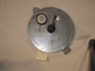
Equipment - AERONAUTICAL COMPUTER, 1957
... .1) Dead reckoning computer model mk - 6 b. Double sided deuce with rotating dials. the dials are profusely covered in numbers, words, graduations. .2) Vinyl pouch to suit computer - brown....Lum (M.A.A.)” .1) Dead reckoning computer model mk - 6 b. Double sided deuce with rotating dials. the dials are profusely covered in numbers, words, graduations. .2) Vinyl pouch to suit computer - brown. ....1) Dead reckoning computer model mk - 6 b. Double sided deuce with rotating dials. the dials are profusely covered in numbers, words, graduations. .2) Vinyl pouch to suit computer - brown.Printed with numerous letters, numbers, arrows, calculations. Hand drawn inscription - “C. Lum (M.A.A.)”computers, equipment -
Moorabbin Air Museum
Archive (Item) - Box WP8 Prowse Collection See details under Description Section
... Manual of Air Navigation Vol 1 1941 Nomad Flight Manual, GAF Nomad N22S Searchmaster ‘B’ Variant - Operations Manual (3 copies) Nomad N22S Searchmaster ‘L’ Variant - Operations Manual Aircraft Book - French GAF Correspondence Regarding Development of Basic Trainer Aircraft Various - TAA Operational Standards Dalton Dead Reckoning Computer ...Manual of Air Navigation Vol 1 1941 Nomad Flight Manual, GAF Nomad N22S Searchmaster ‘B’ Variant - Operations Manual (3 copies) Nomad N22S Searchmaster ‘L’ Variant - Operations Manual Aircraft Book - French GAF Correspondence Regarding Development of Basic Trainer Aircraft Various - TAA Operational Standards Dalton Dead Reckoning Computer Archive Box WP8 Prowse Collection See details under Description Section ...Description: Turbomeca leaflet Airvan leaflet (12 copies) Flight Computer - US Army Airforces RAAF Defence Instruction AAP 7214-003-4-11 Instrument Systems - IPB Sleigh News Dec 78 Jindivik Project Production Bulletins - Various Flight Manual - Jindivik Mk 3A A Level of Importance: State. -
 4th/19th Prince of Wales's Light Horse Regiment Unit History Room
Functional object - Sun Compass
... In featureless country navigation was by dead reckoning by direction travelled by compass and distance travelled from the vehicle odometer. ...In featureless country navigation was by dead reckoning by direction travelled by compass and distance travelled from the vehicle odometer. ...This type of kit was used by the Regiment for vehicular cross country navigation. The crew commander would stand in front of the vehicle with a prismatic compass and guide the driver to align the vehicle on the back bearing of the required direction of travel. The discs were set for time of day and the required bearing and the driver would watch the compass and steer so that the shadow of the gnome was on the arrow. The compass would be re-set about every half hour to adjust for rotation of the Earth. In featureless country navigation was by dead reckoning by direction travelled by compass and distance travelled from the vehicle odometer. Armoured vehicles are now equipped with GPS navigation aids rendering the sun compass obsolete Type of equipment used by the Regiment on exercisesMetal construction. One fixed and one rotatable aluminium disc with a vertical steel gnome at the centre. The lower disc is marked with bearings in mils, the upper with time of day. There is a rotatable aluminium arrow under the 2 discs. A 33 mm dia spirit level is fixed to the top disc.On spirit level "GENERAL #847"daytime use only, navigation aid -
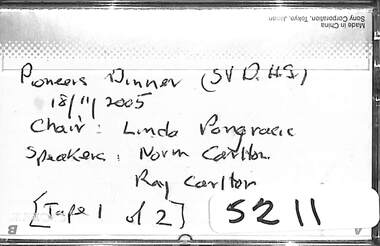
 Sunshine and District Historical Society Incorporated
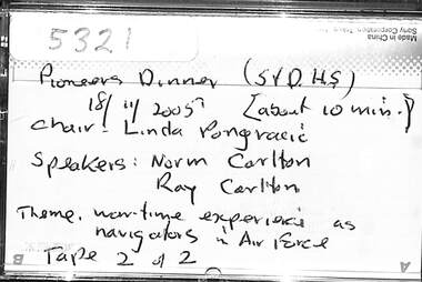
Audio - Sunshine And District Historical Society Pioneers Dinner 2005 Audio Tape 2, Sunshine and District Historical Society Inc, 2005
... Guest speakers Norm Carlton and Ray Carlton 'Wartime experiences as navigators in the Air Force' During WW11 Air Force navigators used a combination of dead reckoning, celestial navigation and radio navigation to guide aircraft. ...Guest speakers Norm Carlton and Ray Carlton 'Wartime experiences as navigators in the Air Force' During WW11 Air Force navigators used a combination of dead reckoning, celestial navigation and radio navigation to guide aircraft. ...The Sunshine and District Historical Society Pioneers’ Lunch / Dinner is an annual event. It’s a commemorative gathering that honours the early settlers, people, community leaders of Sunshine and the surrounding district, events, achievements, etc. At the Pioneers’ Lunch / Dinner, a toast is a ritual and a dedicated moment to honour the original settlers and their contributions, and a guest speaker talks about an interesting subject. Guest speakers Norm Carlton and Ray Carlton 'Wartime experiences as navigators in the Air Force' During WW11 Air Force navigators used a combination of dead reckoning, celestial navigation and radio navigation to guide aircraft. Navigators underwent intensive training to build their skills and adapt to changing conditions including night and bad weather flights.ray carlton, norm carlton, world war 1939 - 1945 -
 Sunshine and District Historical Society Incorporated
Audio - Sunshine And District Historical Society Pioneers Dinner 2005 Audio Tape 1
... Guest speakers Norm Carlton and Ray Carlton 'Wartime experiences as navigators in the Air Force' During WW11 Air Force navigators used a combination of dead reckoning, celestial navigation and radio navigation to guide aircraft. ...Guest speakers Norm Carlton and Ray Carlton 'Wartime experiences as navigators in the Air Force' During WW11 Air Force navigators used a combination of dead reckoning, celestial navigation and radio navigation to guide aircraft. ...The Sunshine and District Historical Society Pioneers’ Lunch / Dinner is an annual event. It’s a commemorative gathering that honours the early settlers, people, community leaders of Sunshine and the surrounding district, events, achievements, etc. At the Pioneers’ Lunch / Dinner, a toast is a ritual and a dedicated moment to honour the original settlers and their contributions, and a guest speaker talks about an interesting subject. Guest speakers Norm Carlton and Ray Carlton 'Wartime experiences as navigators in the Air Force' During WW11 Air Force navigators used a combination of dead reckoning, celestial navigation and radio navigation to guide aircraft. Navigators underwent intensive training to build their skills and adapt to changing conditions including night and bad weather flights.Pioneers Dinner (S&DHS) Chair Linda Pongracic Speakers Norm Carlton & Ray Carltonair force navigators, norm carlton, ray carlton, pioneers dinner, world war 1939 - 1945