Showing 1274 items matching "depth"
-
 Kew Historical Society Inc
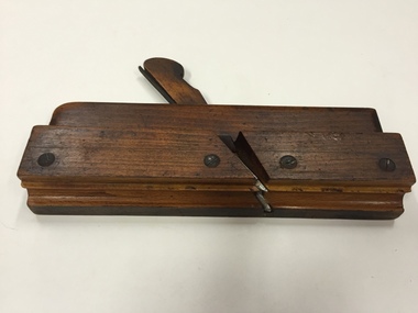
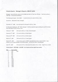
Tool, Mathieson & Son, Moulding Plane, 7/8" Rebate with scriber & depth adjuster, 19th Century
... Moulding Plane, 7/8" Rebate with scriber & depth adjuster...Plane - Wooden Moulding, Beechwood & Metal, 7/8" Rebate with scriber & depth adjuster, Mathieson & Son Glasgow....Plane - Wooden Moulding, Beechwood & Metal, 7/8" Rebate with scriber & depth adjuster, Mathieson & Son Glasgow. Moulding Plane, 7/8" Rebate with scriber & depth adjuster Tool Tool Mathieson & Son ...In woodworking, a moulding plane is a specialised plane used for making the complex shapes found in wooden mouldings. Traditionally, moulding planes were blocks of wear resistant hardwood, often beech or maple, which were worked to the shape of the intended moulding. The blade, or iron was likewise formed to the intended moulding profile and secured in the body of the plane with a wooden wedge. A traditional cabinetmakers shop might have many, perhaps hundreds, of moulding planes for the full range of work to be performed.Bertie Robert Edgar Greenwood was born c. 1880/81 and died aged 82 in Hawthorn in 1963. His father and possibly his grandfather were also carpenters. Bertie’s work as a cabinetmaker required precise planing to give lovely edges and other elaborate decorations. The major item in the tool collection is Bertie’s wooden box, which houses 45 different moulding planes. Later in his life, he used these skills extensively when he worked as a patternmaker for a plastering company. Bertie worked through his seventies, retiring when he lost a finger. The tool collection was donated to the Kew Historical Society by Bertie’s granddaughter, Pamela Webster Bloom, a former resident of Kew.Plane - Wooden Moulding, Beechwood & Metal, 7/8" Rebate with scriber & depth adjuster, Mathieson & Son Glasgow.Stamped with owner name ‘G. Greenwood’, with ‘G’ subsequently over-stamped with ‘B’. Later engraved number ‘26’ added on entering the collection in 2010.woodworking tools, moulding planes, bertie greenwood, carpentry, burwood road — hawthorn (vic.) -
 Kew Historical Society Inc
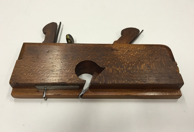
Tool, J Buck, Moulding Plane, 1/2" Rebate with scriber & depth adjust, 19th Century
... Moulding Plane, 1/2" Rebate with scriber & depth adjust...Plane - Wooden Moulding, Beechwood & Metal, 1/2" Rebate with scriber & depth adjust, J Buck 91 Waterloo Rd London. ...Moulding Plane, 1/2" Rebate with scriber & depth adjust Tool Tool J Buck ...In woodworking, a moulding plane is a specialised plane used for making the complex shapes found in wooden mouldings. Traditionally, moulding planes were blocks of wear resistant hardwood, often beech or maple, which were worked to the shape of the intended moulding. The blade, or iron was likewise formed to the intended moulding profile and secured in the body of the plane with a wooden wedge. A traditional cabinetmakers shop might have many, perhaps hundreds, of moulding planes for the full range of work to be performed.Bertie Robert Edgar Greenwood was born c. 1880/81 and died aged 82 in Hawthorn in 1963. His father and possibly his grandfather were also carpenters. Bertie’s work as a cabinetmaker required precise planing to give lovely edges and other elaborate decorations. The major item in the tool collection is Bertie’s wooden box, which houses 45 different moulding planes. Later in his life, he used these skills extensively when he worked as a patternmaker for a plastering company. Bertie worked through his seventies, retiring when he lost a finger. The tool collection was donated to the Kew Historical Society by Bertie’s granddaughter, Pamela Webster Bloom, a former resident of Kew.Plane - Wooden Moulding, Beechwood & Metal, 1/2" Rebate with scriber & depth adjust, J Buck 91 Waterloo Rd London. Stamped ‘4/8’. Also stamped with owner name ‘G. Greenwood’, with ‘G’ subsequently over-stamped with ‘B’. Later engraved number ‘15’ added on entering the collection in 2010.woodworking tools, moulding planes, bertie greenwood, carpentry, burwood road — hawthorn (vic.) -
 Lakes Entrance Historical Society
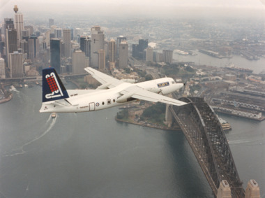
Photograph, R A F, Depth Sounder Fokker Friendship 27, 1990
... Depth Sounder Fokker Friendship 27 ...Colour photograph of the R A N Hydrographic Service Laser Airborne Depth Sounder Fokker Friendship 27 aircraft flying over Sydney Harbour N S W...Lakes Entrance Historical Society 4 Marine Parade Lakes Entrance gippsland Aircraft RAAF Colour photograph of the R A N Hydrographic Service Laser Airborne Depth Sounder Fokker Friendship 27 aircraft flying over Sydney Harbour N S W Depth Sounder Fokker Friendship 27 Photograph R A F ...Colour photograph of the R A N Hydrographic Service Laser Airborne Depth Sounder Fokker Friendship 27 aircraft flying over Sydney Harbour N S Waircraft, raaf -
 National Vietnam Veterans Museum (NVVM)
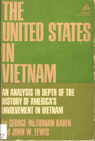
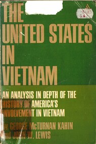
Book, McTurnan Kahin, George and Lewis John W, The United States in Vietnam: An Analysis In Depth Of The History Of America's Involvement In Vietnam (Copy 2)
... The United States in Vietnam: An Analysis In Depth Of The History Of America's Involvement In Vietnam (Copy 2)....The United States in Vietnam: An Analysis In Depth Of The History Of America's Involvement In Vietnam (Copy 2). ...So much has been written from so many divergent points of view about the involvement of the United States in Vietnam that the entire issue has become obscured and the truth is difficult, if not impossible, for the general public to discern.So much has been written from so many divergent points of view about the involvement of the United States in Vietnam that the entire issue has become obscured and the truth is difficult, if not impossible, for the general public to discern. vietnam war, 1961-1975 - united states, vietnam - politics and government -
 National Vietnam Veterans Museum (NVVM)
Book, Kahin, George McTurnan and Lewis John W, The United States in Vietnam: An Analysis In Depth Of The History Of America's Involvement In Vietnam (Copy 1)
... The United States in Vietnam: An Analysis In Depth Of The History Of America's Involvement In Vietnam (Copy 1)....The United States in Vietnam: An Analysis In Depth Of The History Of America's Involvement In Vietnam (Copy 1). ...So much has been written from so many divergent points of view about the involvement of the United States in Vietnam that the entire issue has become obscured and the truth is difficult, if not impossible, for the general public to discern.So much has been written from so many divergent points of view about the involvement of the United States in Vietnam that the entire issue has become obscured and the truth is difficult, if not impossible, for the general public to discern.vietnam war, 1961-1975 - united states, vietnam - politics and government -
 Inverloch Historical Society
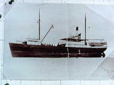
000212 - Photograph - 1910 - Inverloch - Manawatu - Built 1873 - 183 ton - 18 feet 7 inches beam - 128 feet 8 inches long - 9 feet 5 inches depth - R Young
... 000212 - Photograph - 1910 - Inverloch - Manawatu - Built 1873 - 183 ton - 18 feet 7 inches beam - 128 feet 8 inches long - 9 feet 5 inches depth - R Young...Inverloch gippsland 000212 - Photograph - 1910 - Inverloch - Manawatu - Built 1873 - 183 ton - 18 feet 7 inches beam - 128 feet 8 inches long - 9 feet 5 inches depth - R Young ... -
 Lakes Entrance Historical Society
Equipment - Depth Recorder, Royal Depth and Fish Finder
... Royal Depth and Fish Finder...Lakes Entrance Historical Society 4 Marine Parade Lakes Entrance gippsland MARITIME TECHNOLOGY Fisheries Royal Depth and Fish Finder Equipment Depth Recorder Royal ...maritime technology, fisheries -
Lakes Entrance Historical Society
Equipment - Depth Recorder
... Depth Recorder...Lakes Entrance Historical Society 4 Marine Parade Lakes Entrance gippsland MARITIME TECHNOLOGY Fisheries Depth Recorder Equipment Depth Recorder AWA Marine Electronics ...maritime technology, fisheries -
 Department of Energy, Environment and Climate Action
Tool - bark depth gauge
... In the measurement of the diameter of a standing tree, allowance must be made for the depth of the bark if the actual diameter of underlying wood is to be assessed. ...bark depth gauge...SWEDEN; Djos bark depth gauge Tool bark depth gauge ...In the measurement of the diameter of a standing tree, allowance must be made for the depth of the bark if the actual diameter of underlying wood is to be assessed. Used primarily in softwood plantations, the bark gauge provides an alternative to cutting a 'window' into the bark. The sharp end of the gauge is thrust into the bark until it meets the resistance of solid wood. The depth to the wood is then read from the shaft of the gauge.bark depth gaugeSWEDEN; Djos -
 Charlton Golden Grains Museum Inc
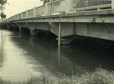
Photograph, Cameron, Ian, 1973 February Flood, Feb 1973
... 1973 flood. High water depth under Paterson Bridge, Charlton Victoria,...B/W photograph of 1973 flood. High water depth under Paterson Bridge....High water depth under Paterson Bridge. 1973 February Flood Photograph Photograph Cameron, Ian Charlton Tribune ...1973 flood. High water depth under Paterson Bridge, Charlton Victoria,B/W photograph of 1973 flood. High water depth under Paterson Bridge.james paterson bridge, charlton, floods -
Hand Tool Preservation Association of Australia Inc
Gauge
... gauge, drill depth...Hand Tool Preservation Association of Australia Inc No physical address melbourne This item is part of the Thomas Caine Tool Collection, owned by The National Trust of Australia (Victoria) and curated by the Hand Tools Preservation Association of Australia. gauge, drill depth Gauge ...This item is part of the Thomas Caine Tool Collection, owned by The National Trust of Australia (Victoria) and curated by the Hand Tools Preservation Association of Australia.gauge, drill depth -
 Federation University Historical Collection
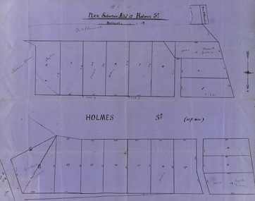
Map, Plan subdivision: Allotment 12 Holmes Street, Ballarat
... North indicated with arrow Sizes of blocks - depth and width ...Some names are marked on the blocks - Taylor (9), Holmes (6), Robert Watson (3), Watson (16), Walter (18),Wetherly (11), Vacant (7) holmes street subdivision allotment 12 holmes taylor robert watson watson wetherly vacant North indicated with arrow Sizes of blocks - depth and width Blue paper with black ink showing the land blocks either side of Holmes Street Each block is numbered - 20 in all Names on some blocks Plan subdivision: Allotment 12 Holmes Street, Ballarat Map Map ...The Allotments drawn in Holmes Street appear to be hand drawn and showing one of the first subdivisions in Ballarat. This was begun in the 1860s. Some names are marked on the blocks - Taylor (9), Holmes (6), Robert Watson (3), Watson (16), Walter (18),Wetherly (11), Vacant (7)Blue paper with black ink showing the land blocks either side of Holmes Street Each block is numbered - 20 in all Names on some blocksNorth indicated with arrow Sizes of blocks - depth and width holmes street, subdivision, allotment 12, holmes, taylor, robert watson, watson, wetherly, vacant -
Hand Tool Preservation Association of Australia Inc
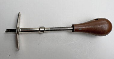
Brace bit
... brace bit, depth gauge...Hand Tool Preservation Association of Australia Inc No physical address melbourne This item is part of the Thomas Caine Tool Collection, owned by The National Trust of Australia (Victoria) and curated by the Hand Tools Preservation Association of Australia. brace bit, depth gauge Brace bit ...This item is part of the Thomas Caine Tool Collection, owned by The National Trust of Australia (Victoria) and curated by the Hand Tools Preservation Association of Australia.brace bit, depth gauge -
 Coal Creek Community Park & Museum
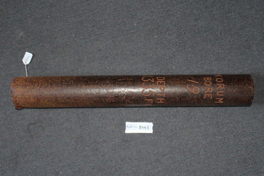
Bore pipe
... - Korum bore 19 - Depth 1335 Ft - 1.64 CHS E...Coal Creek Community Park & Museum 12 Silkstone Road Korumburra gippsland - Korum bore 19 - Depth 1335 Ft - 1.64 CHS E 8443.1 - Metal pipe which is rusted. ...8443.1 - Metal pipe which is rusted.- Korum bore 19 - Depth 1335 Ft - 1.64 CHS E -
 Ringwood and District Historical Society
Photograph, Looking west from Kubis Drive, North Ringwood above the bend of the ridge in February 1978
... The rock was stripped up to 2 metres depth and used to fill the gullies...The rock was stripped up to 2 metres depth and used to fill the gullies Part of a 101-photo record of the development of the "Bel Air" Estate, Ringwood North, including road works to Debbie Place, Kubis Drive, Jenkins Close, Burlock Avenue, Pamela Court, Manuelo Terrace, Lyn Court, Rudolf Court, Werac Drive, Iluka Place and Glenvale Road. ...Part of a 101-photo record of the development of the "Bel Air" Estate, Ringwood North, including road works to Debbie Place, Kubis Drive, Jenkins Close, Burlock Avenue, Pamela Court, Manuelo Terrace, Lyn Court, Rudolf Court, Werac Drive, Iluka Place and Glenvale Road. From the Jack Lundy Clarke collection (39 Burlock Avenue, North Ringwood) of photos taken from 1976 to 1982. The developer, Mr Kubis, named streets after his family and associates.The rock was stripped up to 2 metres depth and used to fill the gullies -
Lakes Entrance Historical Society
Book, Braden, L, Bullockies by L Braden, 1968
... In-depth study of bullock drivers, with 20 illustrations....Lakes Entrance Historical Society 4 Marine Parade Lakes Entrance gippsland Transport In-depth study of bullock drivers, with 20 illustrations. ...In-depth study of bullock drivers, with 20 illustrations.transport -
 Camberwell RSL Sub-Branch
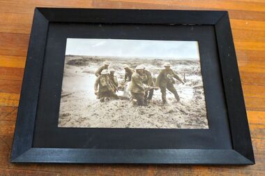
Photo, Photo of seven diggers transporting a wounded digger thru the mud on the Somme in 1917. Note burial cross in background, 1917
... Actual Photo showing the depth of mud on the Somme in 1917...Actual Photo showing the depth of mud on the Somme in 1917 Photo of seven diggers transporting a wounded digger thru the mud on the Somme in 1917. ...Actual photo of the condition on the Somme in 1917UniqueActual Photo showing the depth of mud on the Somme in 1917See Photo, note the burial cross in the mud behind the wounded digger. -
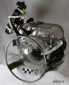 Flagstaff Hill Maritime Museum and Village
Equipment - Camera Housing, Ikelite Underwater Systems, Late 1960s to early 1970s
... This underwater SLR camera housing was made to hold a standard SLR camera and keep it watertight for underwater photography up to 300 feet in depth. Ikelite continues to be a leading manufacturer in the underwater photographic industry. ...Underwater camera housing, Ikelite brand SLR camera housing, for up to 300 feet depth. nscriptions embossed on the back. Made in Indianapolis, USA. ...USA. 300Ft" Underwater camera housing, Ikelite brand SLR camera housing, for up to 300 feet depth. nscriptions embossed on the back. Made in Indianapolis, USA. ...This underwater SLR camera housing was made to hold a standard SLR camera and keep it watertight for underwater photography up to 300 feet in depth. Ikelite continues to be a leading manufacturer in the underwater photographic industry. The business began in the early 1960s when diver Ike Brigham invented a waterproof seal for his underwater flashlights. The name IKELITE was trademarked in 1962. In the late 1960s, Ike developed camera housing kits that were clear and enabled access to change a roll of film. He was the first to use lid-snap closures on an underwater housing. The history of underwater photography began with the first protective camera box for underwater photography was made in 1856. In 1914 the first underwater video footage was taken. Colour underwater photography was first shot in 1926. In 1950 the first commercially available underwater camera housing, the "Tarzan" was designed by Henry Broussard, an underwater photographer, for his own camera. It was produced by the French company Beauchat. In 1957 the revolutionary underwater camera was invented by Jaques-Yves Cousteau and Jean de Wouters. The new amphibious "Calypso" changed the nature of underwater photography.This underwater camera housing is significant for its purpose of underwater photography. Camera housings such as this were used to record the position and layout of shipwrecks along coast of the Great Ocean Road. Flagstaff Hill Maritime Museum and Village has underwater footage of dives that show the now protected shipwrecks.Underwater camera housing, Ikelite brand SLR camera housing, for up to 300 feet depth. nscriptions embossed on the back. Made in Indianapolis, USA. Embossed "Ikelite SLR camera housing. Made in Indianapolis. Ind. USA. 300Ft"flagstaff hill, flagstaff hill maritime museum and village, warrnambool, maritime museum, maritime village, great ocean road, shipwreck coast, underwater camera housing, ikelite, indianapolis, underwater photography, slr camera housing, ike brigham, camera housing kit -
 Kiewa Valley Historical Society
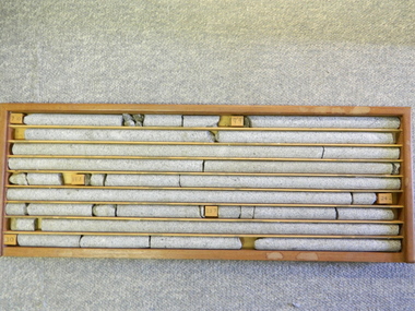
Core Rock Samples
... Within each column are block details of the depth from which that section was brought from. ...Depth levels (retrieved from) are shown for each section on wooden Blocks: 1st Block: "7'10" (seven feet, ten inches), 2nd Block:"9'4" (nine feet, four inches), 3rd Block: "19'3" (nineteen feet, three inches), 4th Block: "24'2" (twenty four feet, two inches), 5th Block: "25'7"( twenty five feet, seven inches) and last block: "30' (thirty feet)"...Within each column are block details of the depth from which that section was brought from. ...The core samples in the display cabinet were obtained from the various sites at which drilling into the rock surface was carried out (under the control of design and structural engineers of the SEC Kiewa Hydro Scheme - late 1940's). This function was a precursor to the decision where to locate, in this case, the McKay Creek Power Station. The information gained by structural engineers from the core samples would be used also for the placements of underground tunnels entry and exit points and the overall effective size of the generator plant. This would have included drill and blast techniques (rock characteristics play an import part of explosion control), requirements for support structures and reinforcing cement/steel forms. The use and replenishment of diamond drill bits(the strongest available, see KVHS 0280) was dependent on the "type" of rock found (harder rock required greater numbers of drill bits). Support beams for reinforced ceilings and floors was also a necessity.These rock core samples are very significant in the formulation and placement of the underground Power Stations and their maze of tunnels (in and out) for a successful implementation of the Hydro Scheme. The amount of pre-planning and engineering studies required for such a large scheme must be undertaken to ensure that a "white elephant" was not the result.There are nine columns of rock cores, each 30mm in diameter, set in a wooden display rack. A clear plastic (slide out) protective panel is installed to the front section. Within each column are block details of the depth from which that section was brought from. See KVHS for the appropriate sketch details.Depth levels (retrieved from) are shown for each section on wooden Blocks: 1st Block: "7'10" (seven feet, ten inches), 2nd Block:"9'4" (nine feet, four inches), 3rd Block: "19'3" (nineteen feet, three inches), 4th Block: "24'2" (twenty four feet, two inches), 5th Block: "25'7"( twenty five feet, seven inches) and last block: "30' (thirty feet)"alternate energy supplies, alpine feasibility studies temperature, rainfall, sec, kiewa hydro scheme, electricity -
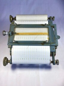 Queenscliffe Maritime Museum
Instrument - Depth Recorder
... Marlin Depth recorder DIR 110A paper type recorder ...Queenscliffe Maritime Museum 2 Wharf St Queenscliff geelong-and-the-bellarine-peninsula Fishing Depth recorder Instruments Marlin Depth recorder DIR 110A paper type recorder Instrument Depth Recorder ...Marlin Depth recorder DIR 110A paper type recorder fishing, depth recorder, instruments -
Lakes Entrance Historical Society
Equipment - Fish Finder
... Royal Depth& Fish Finder and Recorder. Model no. ...Lakes Entrance Historical Society 4 Marine Parade Lakes Entrance gippsland MARITIME TECHNOLOGY Fisheries Royal Depth& Fish Finder and Recorder. Model no. ...Royal Depth& Fish Finder and Recorder. Model no. RF-160Rmaritime technology, fisheries -
 Flagstaff Hill Maritime Museum and Village
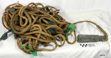
Equipment - Lead line
... The lead line or hand lead is a simple navigational instrument used as a depth finder to measure the depth of water under the ship’s keel and to take samples of the sea bed. ...Lead line, sounding line or depth finder. The long length of rope has a heavy lead weight attached to the end. ...Flagstaff Hill Maritime Museum and Village 89 Merri Street Warrnambool great-ocean-road The lead line or hand lead is a simple navigational instrument used as a depth finder to measure the depth of water under the ship’s keel and to take samples of the sea bed. ...The lead line or hand lead is a simple navigational instrument used as a depth finder to measure the depth of water under the ship’s keel and to take samples of the sea bed. The long line may be marked at regular intervals with tags of different coloured and textured fabric, such as rope, leather and cloth. Each tag was a code to represent a certain depth. The leadsman’s eyes and hands could distinguish the depth easily as he drew in the lead line, day or night and in poor weather conditions. A standard set of codes for the tags was used so that the depth of the sea could be easily and quickly read. The measurement used was a Fathom, which equals 1.83 metres. The codes were: - 2 fathoms = 2 strips of leather 3 fathoms = 3 strips of leather 5 fathoms = white duck fabric 7 fathoms = red bunting fabric 10 fathoms = leather with a hole 13 fathoms = blue serge fabric 15 fathoms = white duck fabric 17 fathoms = red bunting 20 fathoms = 2 knots The lead weight could be between 7 -14 pounds (3.5 – 6.5kg) and the rope would be approximately 25 fathoms (45m). The hollowed-out end of the weight would hold a stick substance such as tallow or wax, which would pick up samples from the sea bed which would show whether the vessel was close to, or far away from, the shore. The leadsman would stand at the front of the vessel and cast the lead line into the sea. When it hit bottom he would note the tag marker nearest the surface of the water and call out his finding. Then he would haul it up again and examine the kind of matter that adhered to the end of the weight, whether it be sand, mud, gravel, or the colour of it. This information would be given to the ship’s helmsman or navigator and would help indicate the proximity to the land.This handheld lead is an example of early marine navigational equipment used by sailors to travel the seas to measure the depth of the water and sample the nature of the seabed. It helps to understand the history and progress made from the very basic to the sophisticated technology of today.Lead line, sounding line or depth finder. The long length of rope has a heavy lead weight attached to the end. Coloured fabric tags are tied onto the rope at regular intervals, representing different depths. The concave base of weight holds sticky substances such as tallow or beeswax, providing an adhesive surface to collect samples of sea bed like sand, shells or pebbles. flagstaff hill, warrnambool, shipwrecked coast, flagstaff hill maritime museum, maritime museum, shipwreck coast, flagstaff hill maritime village, lead line, depth finder, hand lead, sounding lin, leadsmane, navigation instrument, leadline, hand lead line -
 Bendigo Historical Society Inc.
Document - VICTORIA QUARTZ - MINE MANAGER'S REPORTS 1886-87 YIELDS
... Items mentioned are: depth from the surface, type of stone, crushings and depth of Plat Nos 1 to 13 from the surface....Items mentioned are: depth from the surface, type of stone, crushings and depth of Plat Nos 1 to 13 from the surface. ...Typed copy and a handwritten copy of the Victoria Quartz Manager's Reports, 1886-87 Yields. Items mentioned are: depth from the surface, type of stone, crushings and depth of Plat Nos 1 to 13 from the surface.document, gold, victoria quartz, victoria quartz, victoria quartz mine manager's reports 1886-87 yields, samuel renfrey, 180 boundary -
 Orbost & District Historical Society
sounding lead, before 1871
... A tapered conical shaped piece of a lead, a plummet, used for measuring the depth of water....S.S.Aukland Beware-Reef sounding-lead shipwreck A tapered conical shaped piece of a lead, a plummet, used for measuring the depth of water. sounding lead ...This plummet came from S.S. Auckland which was wrecked at Beware Reef near Cape Conran in 1871. The S.S. Aukland was a two masted , iron screw steamer built by C. Mitchell & Co. in 1863 in Newcastle, England. It was owned by the Australasian Steam Navigation Company who modified it in Sydney. In May 1871, on a voyage from Melbourne to Sydney, it ran into breakers and struck Beware Reef. Conditions were foggy and there was a strong easterly current. All passengers and crew were rescued by the S.S. Macedon. (ref. Victorian Heritage Database)The S.S. Aucckland is archaelogically significant. Beware Reef Marine Sanctuary is located five kilometres south east of Cape Conran. On one side of the reef lie the remains of old shipwrecks, including the SS Auckland, a steamship wrecked on the reef in 1871.A tapered conical shaped piece of a lead, a plummet, used for measuring the depth of water.s.s.aukland beware-reef sounding-lead shipwreck -
 Flagstaff Hill Maritime Museum and Village
Depth Gauge
... Depth gauge, J. Heath stamped on the end, 88mm long, 18mm wide...Flagstaff Hill Maritime Museum and Village 89 Merri Street Warrnambool great-ocean-road Flagstaff Hill Warrnambool Shipwrecked-coast Flagstaff-Hill Flagstaff-Hill-Maritime-Museum Maritime-Museum Shipwreck-coast Flagstaff-Hill-Maritime-Village Depth gauge, J. Heath stamped on the end, 88mm long, 18mm wide Depth Gauge ...Depth gauge, J. Heath stamped on the end, 88mm long, 18mm wideflagstaff hill, warrnambool, shipwrecked-coast, flagstaff-hill, flagstaff-hill-maritime-museum, maritime-museum, shipwreck-coast, flagstaff-hill-maritime-village -
Glenelg Shire Council Cultural Collection
Accessory - Badge - Borough of Portland Proper Officer, "Borough of Portland Proper Officer", 1930-1940
... Measures diameter 5.0cm x Depth 0.7cm...Measures diameter 5.0cm x Depth 0.7cm "Borough of Portland Proper Officer" Accessory Badge - Borough of Portland Proper Officer King, P.J., Melbourne ...Displayed at History HouseMetal badge with pin and clasp. Measures diameter 5.0cm x Depth 0.7cmFront: Borough of/proper officer/Portland -
The Ed Muirhead Physics Museum
Photograph Multiple Beam Interference 0.002 in
... Black and white print of multiple beam interference fringes showing depth of etching...The Ed Muirhead Physics Museum Level 2, The School of Physics, David Caro Building (192) Corner of Elgin and Swanston Streets The University of Melbourne Parkville melbourne Black and white print of multiple beam interference fringes showing depth of etching Photograph Multiple Beam Interference 0.002 in. ...Black and white print of multiple beam interference fringes showing depth of etching -
The Ed Muirhead Physics Museum
Photograph Multiple Beam Interference 0.001 in
... Black and white print of multiple beam interference fringes showing depth of etching...The Ed Muirhead Physics Museum Level 2, The School of Physics, David Caro Building (192) Corner of Elgin and Swanston Streets The University of Melbourne Parkville melbourne Black and white print of multiple beam interference fringes showing depth of etching Photograph Multiple Beam Interference 0.001 in. ...Black and white print of multiple beam interference fringes showing depth of etching -
The Ed Muirhead Physics Museum
Photograph Multiple Beam Interference 0.008 in
... Black and white print of multiple beam interference fringes showing depth of etching...The Ed Muirhead Physics Museum Level 2, The School of Physics, David Caro Building (192) Corner of Elgin and Swanston Streets The University of Melbourne Parkville melbourne Black and white print of multiple beam interference fringes showing depth of etching Photograph Multiple Beam Interference 0.008 in. ...Black and white print of multiple beam interference fringes showing depth of etching -
The Ed Muirhead Physics Museum
Photograph Multiple Beam Interference 0.006 in
... Black and white print of multiple beam interference fringes showing depth of etching...The Ed Muirhead Physics Museum Level 2, The School of Physics, David Caro Building (192) Corner of Elgin and Swanston Streets The University of Melbourne Parkville melbourne Black and white print of multiple beam interference fringes showing depth of etching Photograph Multiple Beam Interference 0.006 in. ...Black and white print of multiple beam interference fringes showing depth of etching