Showing 3 items matching "digital mapping project"
-
 Federation University Historical Collection
BTV6, State Data Cente BTV6 Newsclip, 1990, 1992
... ...Digital Mapping Project...Barker Library (top floor) Mount Helen goldfields Ballarat Technology Park John Sharpham Mt Helen Ballarat University College State Data Centre Computers Frank Sheehan David Kennedy Ian Smith Digital Mapping Project MP4 of State Data Cente BTV6 Newsclip State Data Cente BTV6 Newsclip, 1990 BTV6 ...MP4 of State Data Cente BTV6 Newsclipballarat technology park, john sharpham, mt helen, ballarat university college, state data centre, computers, frank sheehan, david kennedy, ian smith, digital mapping project -
 Bendigo Military Museum
Photograph - Technical Tour of the Army Survey Regiment, Fortuna, Bendigo, c1984
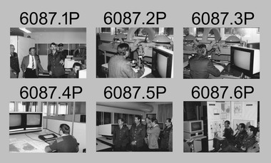
... digital mapping/cartographic systems in Australia and overseas. The system comprised Input (B8 feature extraction) Raster Scanning (digitising from compilation sheets, Graphic Edit (cartographic completion) and Plot Verification Sub Systems. CAPT Rob John was the project...digital mapping/cartographic systems in Australia and overseas. The system comprised Input (B8 feature extraction) Raster Scanning (digitising from compilation sheets, Graphic Edit (cartographic completion) and Plot Verification Sub Systems. CAPT Rob John was the project ...This collection of 10 photos was most likely taken in 1984. It’s evident in these photos the visitors were taken on a tour through the production areas of Air Survey Squadron, with Wild B8 photogrammetic plotting workstations featured in the first three photos and demonstrations of the AUTOMAP 2 production system in the following photos. The AUTOMAP 2 system was an upgrade to the AUTOMAP 1 system comprising Intergraph graphic edit workstation terminals networked to VAX 750/785 main frame computers. Unlike AUTOMAP 1, operators could display digital topographic features on monitors for editing. Successful adaptation of this system meant RASvy was at the forefront of digital mapping/cartographic systems in Australia and overseas. The system comprised Input (B8 feature extraction) Raster Scanning (digitising from compilation sheets, Graphic Edit (cartographic completion) and Plot Verification Sub Systems. CAPT Rob John was the project officer responsible for the acceptance trials and implementation of AUTOMAP 2. The system was operational from 1984 to its ‘Newheart’ upgrade in 1993. Throughout its life, the system was progressively refined with productivity gains, achieved from award winning technical development in-house by talented and innovative Army Survey Regiment personnel.This is a set of 10 photograph of a technical tour of the Army Survey Regiment at Fortuna, Bendigo, c1985. The photographs were printed on 35mm photographic proofing paper and are part of the Army Survey Regiment’s Collection. The photographs were scanned at 600 dpi. .1) - Photo, black & white, c1984, unidentified visitors, CAPT Rob John, MAJ Jim Mitchell, unidentified. .2) - Photo, black & white, c1984, unidentified visitor. .3) - Photo, black & white, c1984, unidentified visitor. .4) - Photo, black & white, c1984, unidentified SGT .5) - Photo, black & white, c1984, L to R: LTCOL Jorge Gruszka, unidentified visitors. .6) - Photo, black & white, c1984, L to R: SGT George Timmins, unidentified visitors. .7) - Photo, black & white, c1984, MAJ John Charland – US Exchange Officer. .8) - Photo, black & white, c1984, L to R: unidentified visitors and personnel, MAJ John Charland – US Exchange Officer. .9) - Photo, black & white, c1984, unidentified visitors and personnel, MAJ John Charland – US Exchange Officer in background. .10) - Photo, black & white, c1984, L to R: MAJ Bob Roche, CAPT Mick Byrne in Officers Mess..1P to .10P No personnel are identifiedroyal australian survey corps, rasvy, army survey regiment, army svy regt, fortuna, asr, air survey, automap -
 Bendigo Historical Society Inc.
Newspaper - Fortuna Article - "Villa fit for a Quartz King", Mar 08 1997
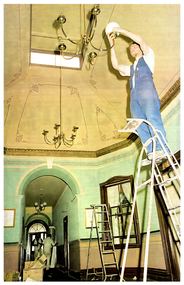
... mapping project at the Army Topographic Support Establishment (ATSE). Workforce ExpansionATSE will increase its staff from 135 to 150, adding 15 new jobs as a result of the project. The project, named Parare, is valued between $8 million and $10 million.Its goal is to position ATSE as a leading defence mapping organization in Australia and internationally.The initiative addresses outdated hardware, enabling the production and distribution of digital defence data across Australia.Project TimelineTenders for the project are set to close soon, indicating the project is in its early procurement phase. ...mapping project at the Army Topographic Support Establishment (ATSE). Workforce ExpansionATSE will increase its staff from 135 to 150, adding 15 new jobs as a result of the project. The project, named Parare, is valued between $8 million and $10 million.Its goal is to position ATSE as a leading defence mapping organization in Australia and internationally.The initiative addresses outdated hardware, enabling the production and distribution of digital defence data across Australia.Project TimelineTenders for the project are set to close soon, indicating the project is in its early procurement phase. ...The article outlines the launch of the Fortuna program's new computer mapping project at the Army Topographic Support Establishment (ATSE). Workforce ExpansionATSE will increase its staff from 135 to 150, adding 15 new jobs as a result of the project. The project, named Parare, is valued between $8 million and $10 million.Its goal is to position ATSE as a leading defence mapping organization in Australia and internationally.The initiative addresses outdated hardware, enabling the production and distribution of digital defence data across Australia.Project TimelineTenders for the project are set to close soon, indicating the project is in its early procurement phase. The historic Fortuna property is undergoing a $1.5 million refurbishment to restore the main building and outbuildings to their original 1870s grandeur. Over 40 workers spent at least two months on the project, which includes new carpets, painting, lighting, rewiring, and rehabilitation of a former stone crushing area. Fortuna Villa was built by George Lansell, a prominent figure in Bendigo's gold mining history, and designed by architects W. C. Vahland and William Beebe. The property has served as home to the Army Survey Regiment for 54 years and was recently taken over by the Army Topographic Support Establishment (ATSE). The fully restored three-level building will open to the public on March 16, with guided tours every Sunday for $8 per person, including devonshire teas in the hall. ATSE will move its production and administrative staff into the villa after renovations, with printing operations at the rehabilitated stone crushing site. State-of-the-art computer equipment will be installed in the building. 20 beer bottles from the 1940s were found in a ceiling.Fortuna Restoration Article - "Villa fit for a Quartz King" - Bendigo Advertiser Sat Mar 08 1997 - Author Ashok Verma This item contains the following: 11217.1a Couloured photo of Brad Murray fixing a light shade as part of the retoration work 11217.1b Part of page 2 - Fortuna Program Maps out new jobs 11217.1c Part of page 2 - Fortuna Program Maps out new jobsnon-fictionbendigo, fortuna, army tropographic support establishment