Showing 90 items matching "discovery school"
-
 Bendigo Historical Society Inc.
Document - MINING IN BENDIGO COLLECTION: DISCOVERY & BENDIGO HIGH SCHOOL
... MINING IN BENDIGO COLLECTION: DISCOVERY & BENDIGO HIGH SCHOOL...Discovery... Bendigo High School...School. Only pages 3 & 4. Document MINING IN BENDIGO COLLECTION: DISCOVERY & BENDIGO HIGH SCHOOL ...Copy of typed notes referring to who was the first to discover gold in Bendigo. Notes describe the area of Camp Hill which was selected as Government Headquarters. The sole remaining relic known as the Police Barracks, a brick stable which was converted into a small hall and the old Supreme Court building. Notes include the history of the Bendigo High School. Only pages 3 & 4.document, gold, mining in bendigo, mining in bendigo, gold discovery, bendigo high school, henry frencham, governor latrobe, gold commissioner horne, captain dane, mr cockburn, mr gilbert, queen elizabeth oval, police barracks building, superintendent mcculloch, high school, teachers' college, supreme court building, town council of sandhurst, corpporate high school, st andrew's college, sandhurst grammar school, bendigo continuation school, camp hill state school, school of mines, domestic arts school, quarry hill state school, congregational church, sir alexander peacock -
 Phillip Island and District Historical Society Inc.
Photograph, 1927
... ...discovery school...It is now (1995) used as a Discovery School for underprivileged families....It is now (1995) used as a Discovery School for underprivileged families. st pauls training school mission of st james and st john ken pound discovery school Sepia photograph of early construction of St Paul's Training School for Boys in Newhaven with Churchill Island in the background. ...St Pauls was built for the Mission of St James and St John Melbourne as a home for wayward boys, opening in 1928. It later became an orphanage. It is now (1995) used as a Discovery School for underprivileged families.Sepia photograph of early construction of St Paul's Training School for Boys in Newhaven with Churchill Island in the background.st pauls training school, mission of st james and st john, ken pound, discovery school -
 Federation University Historical Collection
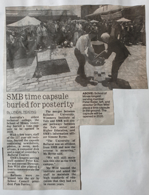
Newspaper, Ballarat School of Mines Time Capsule, 1994
... discovery day...ballarat school of mines...Barker Library (top floor) Mount Helen goldfields Due to the Covid19 Pandemic and associated lockdowns the time capsule was not opened in 2022. time capsule discovery day ballarat school of mines covid19 pandemic merger university of Ballarat wimmera Institute of TAFE The School of Mines and Industries Ballarat Est. 1870 This plaque commemorates the planting of a tree and placing of a time capsule by Dr Ron Wild, the last serving Director of SMB, together with staff to mark the end of the institution prior to its merger with the University of Ballarat and the Wimmera Institute of TAFE 19 December 1997 Time capsule to be opened in 2020 SMB Ballarat School of Mines Time Capsule buried for posterity Ballarat School of Mines Time Capsule Newspaper ...Due to the Covid19 Pandemic and associated lockdowns the time capsule was not opened in 2022. Ballarat School of Mines Time Capsule buried for posterityThe School of Mines and Industries Ballarat Est. 1870 This plaque commemorates the planting of a tree and placing of a time capsule by Dr Ron Wild, the last serving Director of SMB, together with staff to mark the end of the institution prior to its merger with the University of Ballarat and the Wimmera Institute of TAFE 19 December 1997 Time capsule to be opened in 2020 SMBtime capsule, discovery day, ballarat school of mines, covid19, pandemic, merger, university of ballarat, wimmera institute of tafe -
 Ballarat Clarendon College
Book, The laws and principles of whist stated and explained...by "Cavendish', 1895
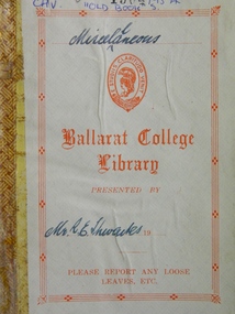
... Until 2014 when this book was catalogued to the Victorian Collections database the first names of Principal Marryat had never been known by the school. The discovery of his presumed personal signature has added significantly to the school's written history. ...Until 2014 when this book was catalogued to the Victorian Collections database the first names of Principal Marryat had never been known by the school. The discovery of his presumed personal signature has added significantly to the school's written history. e-n-marryat ernest-neville-marryat ballarat-college principal 1910s r-e-thwaites Book plate on flyleaf: Crest / Ballarat College / Library / PRESENTED BY / Mr R E Thwaites Handwritten on second page: Ernest Neville Marryat / Christmas / 1897 Tan coloured cloth bound small book with gold lettering and borders on front cover and spine. ...This book was donated by Principal R E Thwaites to the Ballarat College Library, possibly during his years of tenure (1933-45). Fascinatingly the book contains the signiature of a previous principal Ernest Neville Marryat (tenure 1910-1912). Until 2014 when this book was catalogued to the Victorian Collections database the first names of Principal Marryat had never been known by the school. The discovery of his presumed personal signature has added significantly to the school's written history. Tan coloured cloth bound small book with gold lettering and borders on front cover and spine.Book plate on flyleaf: Crest / Ballarat College / Library / PRESENTED BY / Mr R E Thwaites Handwritten on second page: Ernest Neville Marryat / Christmas / 1897e-n-marryat, ernest-neville-marryat, ballarat-college, principal, 1910s, r-e-thwaites -
 Warrnambool and District Historical Society Inc.
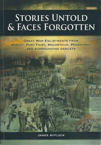
Book, James Affleck, Stories Untold and Faces Forgotten By James Affleck, 2015
... This project started from the discovery of named photographs behind an Honour Roll at the Koroit Primary School during renovations in 2009. ...Warrnambool and District Historical Society Inc. 2 Gilles Street (south of Merri St) Warrnambool great-ocean-road This project started from the discovery of named photographs behind an Honour Roll at the Koroit Primary School during renovations in 2009. ...Stories of western district soldiers who enlisted in World War One.Volume 1 Cover has collage of photographs of soldiers over coloured with different shades of green. Title text is white on black banner. Back cover is in shades of green, yellow and black with photograph of soldier and his bride in the centre. 348 pages Volume 2 has the same front cover with a family plaque on the back cover commemorating the four Dix brothers. Page numbers continue into Volume 2 up to page 654. The full index of names is contained in Volume 2. non-fictionStories of western district soldiers who enlisted in World War One.stories untold and faces forgotten by james affleck., soldiers from the western district ww1, codrington, byaduk, penshurst, caramut, warrnambool, james affleck -
 Warrnambool and District Historical Society Inc.
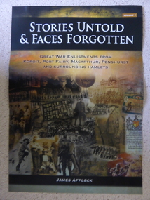
Ephemera - Advertising poster, Stories Untold & Faces Forgotten, 2015
... This poster is advertising the launching of James Affleck’s Book, Stories Untold & Faces Forgotten.”This project started from the discovery of named photographs which were discovered behind an Honour Roll at the Koroit Primary School during renovations in 2009. ...Warrnambool and District Historical Society Inc. 2 Gilles Street (south of Merri St) Warrnambool great-ocean-road This poster is advertising the launching of James Affleck’s Book, Stories Untold & Faces Forgotten.”This project started from the discovery of named photographs which were discovered behind an Honour Roll at the Koroit Primary School during renovations in 2009. ...This poster is advertising the launching of James Affleck’s Book, Stories Untold & Faces Forgotten.”This project started from the discovery of named photographs which were discovered behind an Honour Roll at the Koroit Primary School during renovations in 2009. These two volumes contain enlistments in the First World War, from the area of Koroit, Port Fairy, Macarthur, Penshurst and surrounding hamlets. It stretches from Codrington in the West through to Byaduk, Penshurst, Caramut in the north, and down though Woolsthorpe, Winslow and Dennington. It includes the personal family details, military records, photographs where possible, and fate of each soldier. Enlistments from the district numbered 250 men who paid the supreme sacrifice and 1100 who returned. It includes citations for bravery, excerpts from correspondence and local press.This poster is a link to an important publication relating to the soldiers from the district who fought in World War 1. Photos of soldiers in tones of green and brown with title in white on a black background at the top of poster. Similarly author’s name is at the bottom of poster.stories untold and faces forgotten, james affleck, first world war -
 Federation University Historical Collection
Document, Zelda Martin, Central Victorian Goldmining towns - Boom Towns or Ghost Towns?, c1996
... * Newspaper articles from The Argus, 1849, re the discovery of gold in the Pyrenees region. * Excerpt - a report on schools - A.B.Orlebar, Inspector; re the need for permanent school buildings rather than tents. ... * Newspaper articles from The Argus, 1849, re the discovery of gold in the Pyrenees region. * Excerpt - a report on schools - A.B.Orlebar, Inspector; re the need for permanent school buildings rather than tents. ...Zelda Martin was a PhD candidate at the University of Melbourne.[.1] 4th item in light blue display book titled Research Approach/Overview of Chapters/Confirmation of Canditure/Chapters1,2,3&4 of proposed thesis. *Twenty-seven page article on Victorian goldfields towns titled: Central Victorian Goldmining Towns - Boom Towns or Ghost Towns. The article was written during the author's PhD study. It outlines the context methodology, and resources and the chapters of the proposed thesis: (1) Central Victorian Goldmining Towns - The Context (2) Contemporary Views of the Factors Necessary for Town Growth (3) Outward Manifestations of Town Growth (4) The Trappings of Government (5-9) The Main Towns and Their Hinterland. [.2] 5th item in Light Blue display book as above item. *Chapter 1 of proposed thesis titled 'Pick, Shovel and Tin Dish Mining.' Covers in Section A: Central Victoria - Pre 1851: Aborigines in Central Victoria, Squatters, and Government. Section B: The years 1851-1854: The Early Gold Rushes, Government Reaction, Township Surveys, Legislation, Town Development, Local Government and Early Settlement. [.3] 6th item in Light Blue display book as above item. *2A of proposed thesis titled 'Contemporary Views of the Factors Necessary for Town Growth'. Similar information to Chapter 1 plus extra re towns and maps. Sections: Introduction, Context of Place - Geographical Towns Listed, The Context of Time - Pre1851 Aborigines, Governance of Port Phillip, The Squatters, The Villages of Central Victorian Highlands, Conclusion, Condensed Version of Chapter2B. [.4] 7th item in Light Blue display book as above item. *Chapter2B of proposed thesis. Sections: Area of Research, Schools, Banks, Newspapers, Progress Association, Town Development - Sandhurst (Bendigo), Ballarat, Castlemaine,, Maryborough, Ararat and Stawell. [.5] 8th item in Light Blue display book as above item. *Chapter 3 of proposed thesis titled 'Outward Manifestations of Town Growth'. Sections: Introduction, Contemporary Writing, Educationalists, The Bankers, The Townsfolk, Current Theory, General Theories of Urban Development, and Conclusion. [.6] 9th item in Light Blue display book as above item. *Chapter 4 of proposed thesis titled 'Trappings of Government' Sections: Introduction, Early Government Attitudes to Mining and Town Development, Law and Order, Township Surveys, Legislation, Local Government, Transport and Communication, The People and Lobbyists. [.7] 10th item in Light Blue display book as above item. *'The Rise and Fall of Central Victorian Goldmining Towns'. Includes a map showing main Goldfields, a table showing towns and villages at two points in time - 1857 and 1871; a Bibliography of Primary and Secondary Sources. [.8] Resource No1. Black display book titled Local Towns 1 : Alma: *Brief history *Directory *Maps Amphitheatre / Mountain Hut: *Brief History Post Office Directory Ararat: *Brief History *Post Office Directory 1869 - Alphabetical Listing by Occupation *Ararat - Prominent Citizens of 1858 *Langi-Morgala Museum Avoca: *Brief History *Excerpts from 'Avoca The Early Years', Margery and Betty Beavis; pg1 - Beginnings; pg11 - The Midas Touch; pg25 - Local Gold Escorts; pg27 - A Town is Born; pg51- The Administration of Justice; pg53 - The Ways of the Law; pg61 - News of the Day; pg65 - A Time to Play; pg72 - Land Ownership *Post Office Directory (Bailliere's) 1869 *Tourism Map and Information of area *Historic Avoca - A 5.5km Tour *Avoca & the Pyrenees Region - information pamphlet Ballarat: *Early History of Ballarat - Ballarat Historical Society, Publication No.1: origin of the name; Ballaarat - the Beginning; Fabulous Yields from the Ballaarat Goldfield; *Streetscape Lydiard Street. *Hand drawn map showing Leigh River, Old Portland Bay Road, plaque on road to Colac; etc. *Newspaper article re 'The Theatre Royal' ( which stood in the vicinity of the current Owen Williams store) - 'The News'15/04/1998 *Article - 'Ballarat's Mechanics' Institute Lives On' Ballarat Courier, 14/09/1985 *Article - Standing the Test of Time' The News 17/11/1993 re The Mechanics Institute & picture of the Reading Room *'Ballarat a Study of a City, Phyllis Reichl, pub. Nelson, 1968; no.3 place, time and people field studies series *Investigator Vol.33 No.2, 1998 Geelong Historical Society. Article on pg75 describes Ballarat in 1861 *Folded poster - 'Ballarat 100' a history of telegraph communication, pub. Telecom. Beaufort (Fiery Creek): *Brief history *Post Office Directory [.9] Resource No.2 Black Folder Titled Towns cont.No2 Bendigo (Sandhurst): *'Family & Local History at the Bendigo Library - 1851-2001 150 years of gold'. *Bendigo Government Camp in 1853 illustration; key to sketch and names of Government officers stationed there *Excerpts from 'Bendigo and Vicinity' Adolph Haman *The Bendigo Goldfield Registry - pgs 1-7 Introduction *Excerpt: 'Breaking the Grip' *Excerpt: The Most Go-Ahead Place *Excerpts from 'History of Bendigo' - anti license agitation; laying out of town; proposed railway; gold calls and dividends; the Sandhurst Municipality; journalism *Bibliography Blackwood: *Excerpts from 'Aspects of Early Blackwood - The Goldfield, the Landmarks, the Pioneers' Alan J Buckingham and Margaret F Hitchcock, JG Publishing,1980 Buninyong: *A Brief History *Investigator Vol1 No.2 Feb 1966 Geelong Historical Society. Pg3 - Article re gold escort route - Mt Alexander to Adelaide - (see a simple monument on the Western Highway a few miles out of Horsham. Pg 15 - Ballarat Excursion - re the finding of gold. *Three articles published by Buninyong and District Historical Society Inc: (Magpie Exploration; Finding Gold In The Green Hills; Magpie Exploration; Burnt Bridge to Cargarie to Mt Mercer) *Copies of newspaper articles/items *Buninyong Street Directory Carisbrook: *In the Beginning There Was Carisbrook *The History of the Carisbrook Racecourse Carngham / Snake Valley: *Brief History *Directory Castlemaine: *Directory 1865-1866 - Alphabetical and Street *Poster - Castlemaine A Contemporary Guide "The Great Centre" 1866 - A Contemporary Guide to the Fascinating Past *Pamphlet - Castlemaine District Community Hospital *Map - Castlemaine, Maldon & Surrounding Districts *Map and Information - The Dry Diggings Track - a 55kl walk among historic goldfields relics ( Castlemaine Fryerstown Vaughan Mt Franklin Hepburn Daylesford) *Postcard - Former Court House *Directory 1867 - Alphabetical, Trade [.10] Resource No.3 Grey folder Titled Towns 3 Creswick to Maryborough Creswick: *Brief History *Booklet - "Creswick Cemetery Walk" *Booklet - The Buried Rivers of Gold Heritage Trail Creswick *Creswick Historical Museum Information Sheet *Chronological History of Creswick *Alphabetical Directory of the Borough of Creswick *Creswick's Creek Directory 1856 *Historic Creswick Walking Tour *A Brief Account of the Schools of Creswick - Past and Present *100 Years of Railway Travel in Creswick *The Berry Deep Leads *The Spence Home at Jackass Gully in the Creswick State Forest ( William Guthrie Spence - Pioneer) *The New Australian Mine and the 1882 Disaster *Creswick District News, Issue 7, July August 1999 *The Creswick Miners Walk - Information and Map *Maps Chewton: *Brief History *Directory Clunes: *Brief History *Clunes Street Directory Daylesford: *Brief History *Notable Bushfires in Daylesford District Over More Than a Century - "Black Thursday" 1851; 1862; 1899; the Disastrous Hepburn Fire of 1906; 1939; 1944; 1969. *Post Office Directory -Daylesford and Hepburn Dunolly / Inkerman: *Brief History *Directory *Pamphlet - Goldfields Historical Museum *Pamphlet - Historic Dunolly - Victoria's Best Kept Secret *Map of Gold Workings at Dunolly Area - showing where the main gold rushes occurred *Brief History - Inglewood *Directory - Inglewood - Name Occupation, Dwelling Kingower: *Brief History *Directory - Name / Ocupation / Dwelling Linton / Happy Valley / Piggoreet: *Brief History *Directory - Lintons McIvor: *"A History of the Shire and the Township of Heathcote" by J.O. Randell Majorca: *Brief History *Official Post Office Directory 1869 - Name / Occupation/ Address Maldon (Tarrangower): *Brief History Part 1 *Brief History Part 2 *Post Office Directory *List - Alphabetical Order by Names plus Business and Trade (Tarrangower Times Oct/1858) *List - Alphabetical Order by Trade plus Name and Business *Directory - Name / Occupation / Dwelling Maryborough: *Worsley Cottage - built by Arthur Worsley, a contractor in stonework in 1894 [.11] Resource No. 4 Blue Display Book titled Towns 4 Moliagul to Stawell Moliagul: *Brief History *Moligul Legislative Assembly (Voting?) List - Names and Occupations *Moliagul Victorian Post Office Directory 1868 - Name / Ocupation / Address / Comments *"The Welcome Stranger" gold nugget *The Sunday School *The Welcome Stranger Discovery Walk - information and map Moonambel (Mountain Creek) Redbank *Brief History *List of names extracted from advertisments of the Pioneer and Mountain Creek Advertiser 16/02/1861. *Bailliere's Directory 1869 - Alphabetical List of Name / Occupation / Place St Arnaud: *Brief History Sebastapol: *Brief History *Directory 1869 - Alphabetical by Name; plus occupation and address. Browns and Scarsdale: *Brief History *Browns Street Directory - Name and Occupation Smythesdale: *Brief Description *Smythesdale Street Directory -Name and Occupation Stawell (Pleasant Creek) *Brief History *Victorian Official Post Office Directory - Name /Occupation / Dwelling *Chronology - 1841-1920 *Production of gold statistics - 1879 - 1900 *Big Hill *Extracts from "The Golden Years of Stawell". Chapt 1 - Stawell's Coming Out. Capt. 2 - The Gold Rush. Caapt.3 - Cradle of Democracy. Chapt.4 - The Reefs Becomes Stawell. Chapt. 5 - Rushing In. Chapt.6 - The Pioneers. Chapt 7 - The Decade of Optimism. [.12] Resource No. 5: Blue Display Book titled 'Towns Steiglitz to the The Golden Triangle. Steiglitz: Brief History Victorian Post Office Directory 1869 *Map of Steiglitz *List of maps relevant to Steiglitz history *Information 6 tables of data from "Reports of Mining Surveyors Talbot (Back Creek) Brief History Taradale: Post office Directory 1869 - Name/Occupation/Street. Also list in alphabetical order by Occupation Taradale *Chronological Reference to Taradale Mines *Water - The Coliban System of Waterworks *Joseph Brady *The Syphon Tarnagulla (Sandy Creek) *Brief History *Tarnagulla Businessmen Cameos to give depth to advertisments in 'The Tarnagulla Courier' various issues 1864-1871 *Directory - Name/Occupation /Address *List - Name/Business/Trade Wedderburn (Koorong) *Brief History *List - Name/Occupation The Golden Triangle: *The Early Rushes - Wedderburn / Moliagul / Sandy Creek - Tarnagulla / Jones Creek - Waanyarra / Kingower / Dunolly - Goldsborough / Inglweood *Census of 1857 - Population / Occupations *1858-1871 - A Time of Consolidation- Wedderburn / Moliagul / Sandy Creek- Tarnagulla / Arnold *Census 1871 - Population *Information gleaned from the census data - Demographics / Population / Occupations / marital / Birthplace / Religion / Literacy/ Occupation and Housing Cameos *Graphs - Birthplace of settlers /Male-Female Ratio / Married males / Children under 15 as Percentage of Population / Religion *Census 1857 - Statistical data *Maps *Bibliography [.13] Resource No. 6 - Black Display Book Information and Research in Central Victoria including: *Banking - Research from ANZ Bank Archives *Institutions - also includes articles listed from the Ballarat Times Newspaper *Australian mining History Association - A.M.H.A. Bibliography *Australia's Mining History * Bibliography - Land Surveys Victoria - *1853 Administration (Statistics and Other) includes: schools / ministers of religion / police / military / local administration / licences for sale of spirits / distances between various Victorian gold fields. * Victoria Government Gazette (Copy) - N0. 116, 12/12/1854 includes: Gold Felds Commission of Enquiry & No. 85, 15/09/1854 - Addresses presented to the Lieutenant Governor (Sir Charles Hotham) during his tour through the Gold Fields of Victoria,1854. Addresses on behalf of : the people of Bendigo; Members of the Church of England, Bendigo; Members of the Wesleyan Church on the Bendigo Gold Fields; Bendigo Gold District General Hospital; the Bendigo Prospecting Association; Committee of the Bendigo Local Exhibition; Bendigo District Medical Association; Coloured Americans Resident at Bendigo; German Inhabitants of Bendigo; Landowners, Inhabitants, and Miners of Castlemaine; Inhabitants of Forest Creek; Inhabitants of Heathcote and Gold Miners of McIvor; Residents and landholders of the District of Bacchus Marsh; Inhabitants of Kilmore and Vicinity. *Gold Fields Correspondence 1853: letter from Lieutenant Colonel Valiant, (Officer commanding the Troops in Victoria) to the Lieutenant Governor re threatened disturbance at Sandhurst (Bendigo) regarding the Gold License Fee. * Extracts from a book "Victoria" re Gold Fields Commission of Enquiry involving mainly Ballarat and Castlemaine and a chapter titled 'A Tour to the Victorian Gold-Fields' *Lists of central Victorian newspapers - listed by date published 1851to 1874; by first date available to State Library. *A list of cities and towns showing County, population in 1861 &1871, and municipal status. [.14] Resource no.7. Black display book. *Reference: Papers presented to Parliament Victoria - 1859-1860 4 volumes - relevant sections copied. Contains information on Branches of Government. General / Finance / Gold / Gazette / Commission and Warrant / Statistic. *Gold Fields Act. In accordance with the Act the gold fields are divided into six districts - Ballaarat, Castlemaine , Sandhurst, Avoca, Ararat, and Beechworth.. Official staff in each gold district consists of a Resident Warden, Wardens, Wardens' Clerks, Bailiffs, Chinese Protectors, Chinese Interpreters, and Mining Surveyors. *Gold Receiver *Gaols *Police magistrates and Clerks of Petty Sessions, etc. *Field Branch *Immigration and Emigration Overland - Chinese - 1859 *Population on the Goldfields *The Geological Survey - The Government Geologist is assisited by staff from four branches - the office Branch; the Publishing Branch; the Field Branch and the Museum Branch. *Commission to Enquire Into Sludge dated 10/02/1859 (Some sections copied) - Report to the Honorable Chief Commissioner of Public Works, Melbourne re the mode of carrying the sludge from the puddling mills in Sandhurst without interfering with the drainage of the town and the roads in the neighbourhood. [.15] Resource No.8: Camel display book titled Resource No. 8. Aborigines *Lists of book titles - +"Readings in Victorian prehistory" +"The Aborigines of Port Phillip" +Aboriginal languages and clans" +"A History of the Port Phillip District" +"Langi Ghiran 1: Aboriginal Rock...." +"Koorie History: sources for aboriginal studies in the State Library of Victoria", ed. Tom Griffiths, Melb. Friends of the State Library, 1989 +"The Public Lands of Australia Felix"; settlement and land appraisal in Victoria1834-91 with special reference to the Western Plains", J.M.Powell, Melb. Oxford University Press 1970 +*Bibliography of the Victorian Aborigines' from the earliest manuscripts to 31st December 1970, Massoa, Aldo, Melb. Hawthorn Press, 1971 +"Aborigines in Colonial Victoria, 1836-1886", M.F. Christie, Sydney University Press, 1979 +"Urban and Industrial Australia: readings in Human Geography" ed J.M. Powell, Melb. Sorrett Pub. 1974 *Extracts: -Processes of Pioneer Settlement - The Squatting Occupation of Victoria, 1834-60. J.M. Powell -Areal Variations in the Class Structure of the Central-Place Hierarchy. P. Scott - Volume1 and Volume 2: Notes Relating to the Habits of the Natives of Other Parts of Australia and Tasmania. Compiled from various sources for the Government of Victoria by R Brough Smyth. John Curry, O'Neil, Melb. 1st pub. Melb. 1876. p31-45 - Numbers and Distribution of the Aborigines in Victoria -Victorian Aborigines 1835-1901 - A Resource Guide to the Holdings of the Public Record Office, Victoria; published by the Government Information Centre 1984. *History of the Aboriginal Artefacts Displayed in the Daylesford Museum. F. G. Powell (4 page pamphlet) *Letter to Zelda Martin from Peter Lovett, Cultural Officer, Ballarat & District Aboriginal Co- Operative, 05/02/1997 *Map: Ian Clarke Victorian Tribunal Boundary Map - Clans of Central Victoria. *Victorian Rock Art and Mythology - Article about Mount Langhi Ghiran and myths of the Tjapwarong people. *Two Aboriginal myths relating to the Grampians - 'The Monster Emu' / 'The Aquisition of Fire', by the Aborigines in the Grampians Areas *Article titled (chapter 8) Ballarat - information re camping sites in the region. Lake Wendouree / Lake Burrumbeet (includes a myth) / Mt Bunninyong / Lal Lal / Pitfield / Mount Elephant / Mount Egerton / Meredith / Lake Goldsmith / Lake Learmonth / Ercildoune *Notes on the Aborigines of the Wider Ballarat Region plus European names=Aboriginal names. John Morris 26/07/1995 *Role of Aborigines in Town Development in Central Victoria. Mentions Native Police Force est. in Port Phillip 1842 and Central Board for Aborigines est. 1860 *The Grave of King Billy. (Frank Wilson) Pamphlet. *Camping Places in Central and Northern Victoria. Article re Lake Burrumbeet site. *Programme for the Unveiling of Memorial Cairn for Edward Stone Parker 1802-1865. Note portrait not accurate. Accurate portrait is available in the book "A Successful Failure A Trilogy The Aborigines and Early Settlers", Edgar Morrison, Graffiti Publications, 2002. * Large envelope addressed to Mr G Netherway containing newspaper cuttings regarding the life of Edward Stone Parker, the unveiling of the Memorial Cairn as mentioned above, articles titled 'Episodes from Our Early Days' (Edgar Morrison, Yandoit)- The Black's School, A School At Last and The Final years. Also a typed page titled 'Historical Background to E.S.Parker's Career. Includes an interesting tale titled 'When the cat lay doggo' re laying power leads for the unveiling ceremony at the memorial site. [.16] green display folder titled 'Research Aids' *List of references to Commissioners' & W'ardens' Reports (formerly held at La Trobe Library Archives, now at Public Records Office [PRO]). Indicates town referred to / date of report / name of camp if different to town. * Archive information re Anglican Records *Movement around the Goldfields - Miners and Storekeepers - usefulness of newspapers in providing information - areas covered - Castlemaine, Maldon, Ararat, Stawell, Tarnagulla, Dunolly. *Port Phillip /Victoria Directories 1839/1867 - Chronological list of Directories included in this series. *"Notes on the History of Local Government in Victoria" A.W. Greig Melb. University Press 1925 - Photo-copied extract p5-p40. (Source - Deakin University Library) - Introduction by W.Harrison Moore. Section 1 - Development in New South Wales Before Separation. Section 2 - Development in Victoria After Its Separation from New South Wales. Hand written notations: 'roads, markets, and local government 1855 on' ;'opportunity of squatters in parliament' and 'opportunities of matters in parliament p33' * Notes on the Establishment of Surveyor General's Department 1851and Commissioner of Crown Lands and Survey. * Newspaper articles from The Argus, 1849, re the discovery of gold in the Pyrenees region. * Excerpt - a report on schools - A.B.Orlebar, Inspector; re the need for permanent school buildings rather than tents. *Excerpt from - 'Approaches to Urban History', Sean Glynn: The Case for Caution * Except from - 'The Urban Sprinkle', Weston Bate: Country Towns and Australian Regional History *Reference- 'The History of Land Tenure in the Colony of Victoria', John Quick. References the Haines Land Bill, land tenure and Land Leagues. [.17] Light blue envelope folder titled 'Birtchnell's Ballarat, etc. Directory 1862 *Contains various directories for Smythesdale, Buninyong, Clunes, Brown's and Creswick. [.18] Red envelope folder no.2 titled Victorian Gazetteer *Selected pages from 1869 Victorian Gazetteer on A4 paper (with a handwritten note questioning if some pages are from 1868 Victorian Gazetteer as appears to be different sizes - A3 pages.) Information includes locations and descriptions of towns, hotels, banks, communications and populations. (Does not include names, residences and occupations) [.19] Red Envelope folder titled Bailliere's Official Post Office Directory 1868 (or1869 or a mixture of both?) *Preface *Contains a selection of pages of towns highlighted in yellow in the the index *Work on this directory was commenced in 1867. *Information includes: Municipalities - mayors and councilors; lists of towns naming male inhabitants and their occupations. [.20]Yellow manila folder titled Post Grad Seminar Presentation 1996 *Gives some background to Zelda Martin's proposed thesis and why she chose the topic Gold Mining Towns Boom or Bust [.21] A3 display book - No. 1A * A list of 'Relevant Newspapers collected: The Tarrangower Times and Maldon Advertiser (first published 1858) Includes dates 1858-1867. The Mount Alexander Mail. Includes dates 1854-1866 The Tarnagulla Courier. Includes dates from1864-1871 Dunolly and Burnt Creek Express. Includes dates from 1862-1871 * Selection of newspaper pages from The Mount Alexander Mail 1854 to 1856, mostly showing advertisements for businesses and services provided to that community. [.22] A3 display book - No. 1B * Selection of newspaper pages from The Mount Alexander Mail 1857 to 1866, mostly showing advertisements for businesses and services provided to that community. [.23] A3 display book -No. 2 * Selection of newspaper pages from The Tarnagulla Courier 1864 to 1871, mostly showing advertisements for businesses and services provided to that community. [.24] A3 display book - No. 3 *Selection of newspaper pages from The Tarrangower Times (and Maldon and Newstead) Advertiser 1858 to1867, mostly showing advertisements for businesses and services provided to that community. [.25] A3 display book - No.4 * Selection of newspaper pages from The Dunolly and Burnt Creek Express; and The Dunolly and Betbetshire Express 1862 to 1871, mostly showing advertisements for businesses and services provided for that community. [.26] A3 display book - No.5 Includes: * Bryce Ross's Diggings Directory. Includes instructions for using this directory. This directory was used by "all persons having connexion or desiring to communicate with 'working parties, private friends, or Stores at the Diggings." As a directory for each area wwas completed it was published in each month's issue of Bonwick's "Digger's Magazine." Years c1852/1853. This Directory commences first at the head of Forest Creek. Includes a directory for Bendigo and Ballarat. Of interest at the end of the Bendigo and Ballarat directory is a list of the number of storekeepers, butchers, doctors, smiths, eating houses, lemonade sellers and chapels. * The Castlemaine Directory and Book of General Information Comprehending Glass's Model Calendar for the Two Years 1862 and1863. "zelda martin, victorian goldfield towns, bendigo, castlemaine, ballarat, maldon, stawell, ararat, maryborough, creswick, avoca, heathcote, banks, bank of australasia, union bank of australia, government camp, sandhurst, water supply, tarnagulla, talbot, back creek, mountain creek, police court, carisbrook, dunolly, thompson's foundry, charles clacy, anthony trollope, robert cecil, mount alexander, urbanisation, national schools, education, govenrment, industry, railway, transport, settlement, land settlement in central victoria, steiglitz, joseph brady, the new australian mine, berry deep leads, william guthrie spence, creswick state forest, arthur worsley, worsley cottage, the welcome stranger, moliagul, moonambel, redbank, st arnaud, sebastapol, brown's, scarsdale, clunes, chewton, daylesford, bushfires, inkerman, inglewood, kingower, lintons, happy valley, piggoreet, mcivor, majorca, tarrangower, taradale, the coliban system, the syphon, sandy creek, wedderburn, koorong, arnold, jones creek, waanyarra, the golden triangle, census 1857, blackwood, buninyong, durham lead, magpie, carngham, snake valley, alma, amherst, daisy hill, amphitheatre, mountain hut, beaufort, fiery creek, counties, population, gold fields commission of enquiry1854, william westgarth, gold license fee, lieutenant colonel valiant, administration of the victorian gold fields, commission to enquire into sludge 1859, e.s. parker, edward stone parker, edgar morrison, mount franklin protectorate, dja dja wurrung, memorial cairn, franklinford, mt franklin memorial cairn, jajowurrong, dja dja wurung, tjaowarong, wothowurong, assistant protectors, daylesford museum, buluk, rock art - grampians, aboriginal mythology - grampians, aborigines, first nations people, mount franklin, aboriginal artifacts, lake burrumbeet, native police force, central board of aborigines, yandoit, commissioners' reports, wardens' reports, port phillip/victoria directories 1839-1867, local government - victoria 1853/1854, surveyor general's department - 1850's, victorian schools 1850's, a.b.orlebar, haines land bill, william charles haines, wilson gray, land tenure, land leagues, victorian gazetteer, the tarrangower times and maldon advertiser - 1858-1867, the mount alexander mail 1854-1866, the tarnagulla courier 1864, dunolly and burnt creek express 1862-1871, bryce rose's diggings directory, the castlemaine directory 1862-1863 -
Federation University Historical Collection
Newspaper, A Next mode of motion, 19/03/1896
... Barker Library (top floor) Mount Helen goldfields Ballarat School of Mines produced pioneer x-rays in Australia. x-ray Rontgem A newspaper clipping from the Age on the discovery of the x-ray. ...Ballarat School of Mines produced pioneer x-rays in Australia.A newspaper clipping from the Age on the discovery of the x-ray.x-ray, rontgem -
Federation University Historical Collection
Magazine, Various magazines with articles on Henry Sutton
... School of Mines in 1883 to 1886. Henry Sutton Cosmos forgotten genius the innovative man book launch sutton family Ballarat remembers inventor ballarat historical society amateur radio Ballarat heritage weekend ignite your curiosity learning and discovery ballarat heritage festival Various publications containing articles and information on Henry Sutton .1 Cosmos magazine of the year - Forgotten genius .2 Amateur Radio - Henry Sutton: the innovative man .3 Henry Sutton Book Launch flyer .4 Ballarat Historical Society - Ballarat Remembers - Henry Sutton inventor .5 Ballarat Heritage Festival programs x 3 .6 Ballarat Heritage Weekend Flyer .7 Ballarat international Foto Biennale Booklet .8 Ballarat Heritage Weekend 2017 Booklet .9 Logan City Council Whats On x 2 .10 Ballarat Heritage Weekend 2018 .11 Henry Sutton Biography Booklet .12 Henry Sutton History Walk Booklet .13 Ballarat Courier Newspapers Various magazines with articles on Henry Sutton Magazine ...Various publications containing articles and information on Henry Sutton.1 Cosmos magazine of the year - Forgotten genius .2 Amateur Radio - Henry Sutton: the innovative man .3 Henry Sutton Book Launch flyer .4 Ballarat Historical Society - Ballarat Remembers - Henry Sutton inventor .5 Ballarat Heritage Festival programs x 3 .6 Ballarat Heritage Weekend Flyer .7 Ballarat international Foto Biennale Booklet .8 Ballarat Heritage Weekend 2017 Booklet .9 Logan City Council Whats On x 2 .10 Ballarat Heritage Weekend 2018 .11 Henry Sutton Biography Booklet .12 Henry Sutton History Walk Booklet .13 Ballarat Courier Newspapers non-fictionVarious publications containing articles and information on Henry Suttonhenry sutton, cosmos, forgotten genius, the innovative man, book launch, sutton family, ballarat remembers, inventor, ballarat historical society, amateur radio, ballarat heritage weekend, ignite your curiosity, learning and discovery, ballarat heritage festival -
Federation University Historical Collection
Document - SMB Documents E.J. Barker, Various School of Mines Ballarat Papers collected by E.J. Barker
... School...Former Ballarat Gaol...The Court House...SMB Community Centre...Trust News...Articles...Discovery...School of Mines is a predecessor of Federation University Planning Requirements Individual Rooms Dr Ron Wild School of mines and industries Ballarat Institute Profile Location Map University of Ballarat Campus Plan Great Hall/Arts Complex Notes 1970-72 Building Program Operations and Decisions Report to Council Visit by Principal Priorities Electrical Engineering Mt Helen Minutes of Special Council Meeting University of Melbourne Engineering Mt Helen Development Report Administration Building Technical Art School Former Ballarat Gaol The Court House SMB Community Centre Trust News Articles Discovery Day K.J. ...E.J. Barker is a past principal of the School of Mines Ballarat and the Library at the Mt Helen Campus is named after him. School of Mines is a predecessor of Federation UniversityLetters, Reports Plans, Ephemera and Clipboard associated with E.J. Barker and the School of Mines Ballaratplanning requirements, individual rooms, dr ron wild, school of mines and industries ballarat, institute profile, location map, university of ballarat, campus plan, great hall/arts complex, notes, 1970-72 building program, operations and decisions, report to council, visit by principal, priorities, electrical engineering, mt helen, minutes of special council meeting, university of melbourne, engineering, mt helen development report, administration building, technical art school, former ballarat gaol, the court house, smb community centre, trust news, articles, discovery day, k.j. flecknoe, retirement, membership of sub committee, n.a crouch, e.j. barker, k.l. cross, w.j. gribble, l.f.j. hillman, r.c lovett, d. nicholson, g. robertson, p.r. shiells, b. tanner, r. feary, i. harris, b.c. mclennan, m. stevens, t.a. wiseman, d.r. bolster, p.h. dixon, r. dunlop, r. furness, e.j. lumsdon, a. mccaffrey, p.r. davies, d. farnsworth, j. harrison, k. mcfarlane, j. mills, s.a. mendelson, i. robinson, d.j. fraser, j. van dreven, k. alsop, b. bridges, m. palmer, r. sutton, l. snibson, h. van hammond, t. runnalls, p. sculley, g. shearer, t. slater, michael ronaldson, robert lovett, edward john barker, e.j. barker building, council membership, clipboard, n.g curry, state college of victoria, articles of association, memorandum, australian conference of principles of colleges of advanced education, commonwealth ministerial working party, victorian post secondary education commission, australian institute of physics symposium, royal australian institute of public administration, premier of victoria, r.j. hamer, m.b. john, new south wales institute of technology, phone messages, peter o'loughlin, annual report, signing of agreement, position description, certificates, fifth form -
 Ballarat Clarendon College
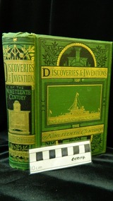
Book, Robert Routledge, Discoveries and inventions of the nineteenth century, 1877
... Four generations of descendants have attended the school. robert-crawford 1878 ballarat-college john-garbutt book-prize Book plate inside front cover; Ballarat College crest / French / Third from / First PRIZE / Awarded to / R Crawford / CHRISTMAS 1878 / JOHN GARBUTT M A PRINCIPAL Green cloth cover with ornate gilt decorations and black pictorials on cover and spine; gilt edges; binding breaking but overall fair condition; black and white illustrations throughout; Discoveries and inventions of the nineteenth century Book Robert Routledge George Routledge and Sons ...Awarded to Robert Crawford for excellence in French at the Third form; Robert (BD 14/3/1865) entered the school on 9/7/1878 and left 31/12/1881. He was Dux of Ballarat College 1881. Four generations of descendants have attended the school. Green cloth cover with ornate gilt decorations and black pictorials on cover and spine; gilt edges; binding breaking but overall fair condition; black and white illustrations throughout; Book plate inside front cover; Ballarat College crest / French / Third from / First PRIZE / Awarded to / R Crawford / CHRISTMAS 1878 / JOHN GARBUTT M A PRINCIPALrobert-crawford, 1878, ballarat-college, john-garbutt, book-prize, -
 Federation University Historical Collection
Document, Cyclopedia of Victoria: Ballarat , 1904, 1904
... discovery...Lake Wendouree...Boat House...sailing...Eureka Stockade...Ballarat Botanical Gardens...Statuary...statues...Ballarat SChool...Barker Library (top floor) Mount Helen goldfields cyclopedia of victoria ballarat Ballarat BEnevolent Asylum John Adam gold discovery Lake Wendouree Boat House sailing Eureka Stockade Ballarat Botanical Gardens Statuary statues Ballarat SChool of Mines Ballarat Town Hall Sturt Street Shoppee Square Ballarat Ballarat Mecahanics' Institute Ballarat hospital Henry Cuthbert Charles Collett Shoppee John Murray Richard Greenwood Middleton John M. ...Digital images of the Ballarat section of the Cyclopedia of Victoria, 1904cyclopedia of victoria, ballarat, ballarat benevolent asylum, john adam, gold discovery, lake wendouree, boat house, sailing, eureka stockade, ballarat botanical gardens, statuary, statues, ballarat school of mines, ballarat town hall, sturt street, shoppee square ballarat, ballarat mecahanics' institute, ballarat hospital, henry cuthbert, charles collett shoppee, john murray, richard greenwood middleton, john m. kline, john ritchie, thomas stoddart, william little, john robson, hugh v. mckay, h.v. mckay, n. clark, a. h. powell, r.j. powell, edward shaw, charles j. reid, frederick g. haymes, james thomas mitchell, robert scott, frane longden, robert d. pinnock, thomas a. wilson, sydney b. fisher, david bartholomew, t.r. treloar, s-ray, w. cornell, alexander greenfield, andrew callow, victorian mounted rifles, s.g. valentine, andrew scott, thomas robertson, john gordon robertspm, w.t. rowe, thomas a. oddie, william morris, jospeh walshe, william acheson, joseph dill, william mason, llanberis no 1, anthony jenkin, james carey, wlliam emery, percy kent, henry bath, j. rowe, john couttie, william sansom, francis coote, john mckenna, robert ditchburn, thomas mitchell, john daniel, george williams, william treloar, r.b. squire, jonah ward, robert smyth, william bell, thomas couper, w. joseph, william wallace, benjamin dowling, robert crawford, alexander aikens, c. dennison, w.f. coltman, federal timber yard, george hotel, williaim dones, j. dreaden, richard's and co, j.a. gear, r.w. fleming, l.e. cutter, l.s. cutter, a.e. cutter, c.f. cutter, george anderson, w.e. longhurst, christopher howlett, david mcgrath, james wishart, f.g. reeve, eureka iron works, j.e. cowley, albert foundry, john robert harrison, j.b. cameron, p.b. sutherland, george richards, ballarat brass foundry, m.b. john, morgan john, m.w.b. john, james smith, w.p. davies, j.t. vercoe, james kelly, williaim osbourne, alexander mcdonald, alexander e. mcdonald, henry john symons, bridge street flood -
Federation University Historical Collection
Book - Book - Scrapbook, Ballarat School of Mines: Scrapbook of Newspaper Cuttings, Book 45, September 1990 to November 1990
... School Of Mines.They cover activities and advertisements for staff. The papers concerned are The Courier, Ballarat, The Australian, The Age over the period of 8 September 1990 to 24 November 1990. teaching positions advertised pre-employment courses courses available enrolment for smb courses discovery day at smb ricky dixon bricklaying contest brotherhood of st laurence employment action centre work skill australia expo judy-ann williams - wins work skill finals graig bennetts winning apprentice pottery workshop with gwyn hanssen-pigott students reunion 1940s-1960s bunning exhibition geoff mainwaring and robert tantau vocational information centre co-ordinator martin murley crowd control course at smb bouncer darren quick grant rundell art exhibition fee proposed for tafe students smb hospitality awards department of employment education and training deet smb 120th year phoebe rimmer designs sebastopol borough logo smb staff work at gallery betty collier's "emu"jobs illustrated unit exhibition "walter the shark" by smb staff val d'angri fabric restoration paul lambeth photography betty collier metal sculptures prue venables and neville french ceramics alister heighway painter disability awareness day runaway cars art at smb student exhibition tuition fees for tafe students home care workers course at smb open day Book with yellow cover, front, spiral bound. ...Collection of newspaper articles related to Ballarat School Of Mines.They cover activities and advertisements for staff. The papers concerned are The Courier, Ballarat, The Australian, The Age over the period of 8 September 1990 to 24 November 1990.Book with yellow cover, front, spiral bound. teaching positions advertised, pre-employment courses, courses available, enrolment for smb courses, discovery day at smb, ricky dixon bricklaying contest, brotherhood of st laurence employment action centre, work skill australia expo, judy-ann williams - wins work skill finals, graig bennetts winning apprentice, pottery workshop with gwyn hanssen-pigott, students reunion 1940s-1960s, bunning exhibition, geoff mainwaring and robert tantau, vocational information centre co-ordinator martin murley, crowd control course at smb, bouncer darren quick, grant rundell art exhibition, fee proposed for tafe students, smb hospitality awards, department of employment education and training, deet, smb 120th year, phoebe rimmer designs sebastopol borough logo, smb staff work at gallery, betty collier's "emu"jobs illustrated unit, exhibition "walter the shark" by smb staff, val d'angri fabric restoration, paul lambeth photography, betty collier metal sculptures, prue venables and neville french ceramics, alister heighway painter, disability awareness day, runaway cars, art at smb student exhibition, tuition fees for tafe students, home care workers course at smb, open day -
Federation University Historical Collection
Book - Book - Scrapbook, Ballarat School of MInes: Scrapbook of Newspaper Cuttings, Book 49, August 1991 to October 1991
... school...budget cuts threat to staffing...rick britton wins scholarship...john jelbert with new microscope...computer graphics on display...ballarat artists support philippines tribe...smb discovery...The papers concerned are The Courier, Ballarat, The Australian, The Age over the period of 1 August 1991 to 14 October 1991 teaching positions advertised pre-employment courses courses available enrolment for smb courses glen flenley boilermaking certificate neil ham farming certificate tafe teachers continue bans sec helps smb apprentices shane jeffrey apprentice of the year funds to retain apprentices businesses' generosity eliminates costs joan kirner opens new smb facilities jennifer mckay wins westpac award $170000 grant boosts programs women's trade and technical certificate sharon mclennan kerrie firns petrena brookes deb goudappel claire bond farming apprentices shearing workshop anne bartlett cocktail creator christine becker and jan palmerreturn to school budget cuts threat to staffing rick britton wins scholarship john jelbert with new microscope computer graphics on display ballarat artists support philippines tribe smb discovery day open day Book with yellow cover, front, spiral bound. ...Collection of newspaper articles related to Ballarat School Of Mines.They cover activities and advertisements for staff. The papers concerned are The Courier, Ballarat, The Australian, The Age over the period of 1 August 1991 to 14 October 1991Book with yellow cover, front, spiral bound. teaching positions advertised, pre-employment courses, courses available, enrolment for smb courses, glen flenley boilermaking certificate, neil ham farming certificate, tafe teachers continue bans, sec helps smb apprentices, shane jeffrey apprentice of the year, funds to retain apprentices, businesses' generosity eliminates costs, joan kirner opens new smb facilities, jennifer mckay wins westpac award, $170000 grant boosts programs, women's trade and technical certificate, sharon mclennan, kerrie firns, petrena brookes, deb goudappel, claire bond, farming apprentices shearing workshop, anne bartlett cocktail creator, christine becker and jan palmerreturn to school, budget cuts threat to staffing, rick britton wins scholarship, john jelbert with new microscope, computer graphics on display, ballarat artists support philippines tribe, smb discovery day, open day -
Federation University Historical Collection
Book - Book - Scrapbook, Ballarat School of MInes: Scrapbook of Newspaper Cuttings, Book 63, July 1994 to September 1994
... School Of Mines.They cover activities and advertisements for staff. The papers concerned are The Courier, Ballarat, The Australian, The Age over the period of 23 July 1994 to 7 September 1994. teaching positions advertised pre-employment courses courses available enrolment for smb courses ag education lacks coordination new vice chancellor at work apprentice awards craftsmanship certificates presented real estate industry training uni and smb seal pact mark dawe best automotive apprentice centre's youth ready to work michael strahan challenge day rivals bendix gives jobs to unemployed matthew barlow mansion now st pat's site discovery daysmb tafe skill olympics regional chairman peter morey work skills display at smb course scan computer robotron rainbow machine reading machine Open Day herbert werner frederick de nully Book with yellow cover, front, spiral bound. ...Collection of newspaper articles related to Ballarat School Of Mines.They cover activities and advertisements for staff. The papers concerned are The Courier, Ballarat, The Australian, The Age over the period of 23 July 1994 to 7 September 1994.Book with yellow cover, front, spiral bound. teaching positions advertised, pre-employment courses, courses available, enrolment for smb courses, ag education lacks coordination, new vice chancellor at work, apprentice awards, craftsmanship certificates presented, real estate industry training, uni and smb seal pact, mark dawe best automotive apprentice, centre's youth ready to work, michael strahan, challenge day rivals, bendix gives jobs to unemployed, matthew barlow, mansion now st pat's site, discovery daysmb tafe, skill olympics, regional chairman peter morey, work skills display at smb, course scan computer, robotron rainbow machine, reading machine, open day, herbert werner frederick de nully -
Federation University Historical Collection
Book - Book - Scrapbook, Ballarat Institute of Advanced Education: Scrapbook of newspaper cutting, Book 3, July 1970 to December 1970
... The cuttings cover the period from 7 July 1970 to 12 December 1970. ballarat institute of advanced education biae employment advertisements early school records found council records from 1870 - 1893 john lynch wins stock exchange award b r hames to deliver lecture at smb death of a w steane biae motor cycle club visit factory mount helen campus of the future visit from mt isa officer centenary celebrations peter hensley outstanding academic record 1969 rosslynne guymer hill climb repco gives $5000 to smb fund ray woolard artist mineral discoveries in australia centenary prediction centenary medallion betty archdale to deliver fourth lecture looking back on school history e j tippett threshold of the second century e j barker stanley white awarded csiro doctoral scholarship tertiary colleges should be community centre post-diploma course in malting and brewing young geologists from broken hill technical conference for ballarat banks' gift exhibition by students rare rocks for biae teachers' college at mt helen? ...Newspaper cuttings relating to Ballarat Institute of Advanced Education. These are from various newspapers and include The Age, Ballarat Courier, The Australian, The Herald. The cuttings cover the period from 7 July 1970 to 12 December 1970. Book with yellow cover, front. Spiral bound.ballarat institute of advanced education, biae, employment advertisements, early school records found, council records from 1870 - 1893, john lynch wins stock exchange award, b r hames to deliver lecture at smb, death of a w steane, biae motor cycle club visit factory, mount helen campus of the future, visit from mt isa officer, centenary celebrations, peter hensley outstanding academic record 1969, rosslynne guymer, hill climb, repco gives $5000 to smb fund, ray woolard artist, mineral discoveries in australia, centenary prediction, centenary medallion, betty archdale to deliver fourth lecture, looking back on school history, e j tippett, threshold of the second century, e j barker, stanley white awarded csiro doctoral scholarship, tertiary colleges should be community centre, post-diploma course in malting and brewing, young geologists from broken hill, technical conference for ballarat, banks' gift, exhibition by students, rare rocks for biae, teachers' college at mt helen?, technical principals' association, miss n findley of emily mcpherson college, visiting heads admire facilities at biae, advisory council sets guidelines, smb plaque unveiled, $25000 to centenary appeal, national service exemption granted, technical schools disrupted by teachers' strike, bid for fourth university, librarian course advocated, smb appeal at $221000, centenary of technical education in australia, mt helen campus opening, centenary of great achievement, governments give $100000 to institute, student from last century, mrs o ratray, biae asked to train librarians, buninyong seek talks, problems of "background" in education, exhibition by jon crawley - potter, mr thompson's comment, art sake at school, 90 engineers at biae, ray woollard -
 Eltham District Historical Society Inc
Photograph - Aerial Photograph, Landata, Eltham; Crown Allotment 15, Section 5, Parish of Nillumbik (Stokes Orchard Estate), Dec. 1945
... school purposes, except for the sections north of Diosma Road and between the transmission lines and Reynolds Road. Sewerage issues had been resolved for the section north of Diosma Road and in 1987 it was in the process of being subdivided into residential lots. The development coincided with the discovery...school purposes, except for the sections north of Diosma Road and between the transmission lines and Reynolds Road. Sewerage issues had been resolved for the section north of Diosma Road and in 1987 it was in the process of being subdivided into residential lots. The development coincided with the discovery ...Centred on present day Diosma Rd, Stokes Pl, Nyora Rd and Eucalyptus Rd Historic Aerial Imagery Source: Landata.vic.gov.au Aerial Photo Details: Project No :5 Project : MELBOURNE AND METROPOLITAN AREA PROJECT Run : 36 Frame : 60546 Date : 12/1945 Film Type : B/W Camera : EAG4 Flying Height : 10200 Scale : 6000 Film Number : 195 GDA2020 : 37°42'47"S, 145°09'56"E MGA2020 : 338306, 5824438 (55) Melways : 22 C4 (ed. 42) A History of the Development of Crown Allotment 15, Section 5, Parish of Nillumbik – Stokes Orchard Crown Allotment 15, Section 5, Parish of Nillumbik (CA15) is a square allotment of 158 acres or approximately a quarter of a square mile. It lies just beyond the eastern end of Pitt Street, south of Nyora Road to the northern end of Eucalyptus Road and extends east from Eucalyptus Road to Reynolds Road. The topography of CA15 is generally steep, sloping up to a hill near the centre of the land, the ridgeline passing through the properties along the southern side of Diosma Road. Eucalyptus Road is a straight north-south road with its northern end at the north west corner of CA15. Until the end of the 1970s this road was an un-named Government Road and was largely not open to traffic. With residential development in the 1970s the road was constructed, and the council allocated the name obviously in recognition of the predominant species of the local bushland. CA15 was purchased from the Crown by George D’Arley Boursiquot, a prominent Melbourne printer, on 28th October 1852. On November 23, 1922, former Member for Gippsland and Melbourne Real Estate Agent, Hubert Patrick Keogh purchased the allotment then sold it March 13, 1925, to local farmer, Robert David Taylor, a former Shire of Eltham Councillor (1911-1920) and Shire President (1919). Taylor had extensive land holdings stretching west towards Bible Street and Main Road. The Taylor home was situated at the top of the hill in Bible Street at present day 82 Bible Street. At the time of Taylor’s purchase in 1925, CA15 was subdivided into 48 lots that could be described as small rural properties or large residential lots. A typical lot size was one hectare or 2.5 acres. The subdivision created two roads, Nyora Road, and Diosma Road, each following an irregular alignment between Eucalyptus and Reynolds Roads. However, the lots were not sold off separately nor were the roads constructed. The land effectively remained as one parcel for many further years. Robert David Taylor died November 30, 1934, and probate was granted to his son of the same name, Robert David Taylor of Bible Street, Salesman and William McLelland Vance Taylor of 73 Emmeline Street, Northcote, Clerk, with the transfer of the land into their names on July 8, 1935. Frank Stokes worked as a qualified accountant at Kennons leather factory in Burnley, while living at 1 Thomas Street, Mitcham. He suffered from migraines and wanted to return to working the land (he had previously worked on farms and orchards since coming to Australia from England in 1926, both in WA and Vic.). He first travelled to the district by train in July 1942 to find land with the intention to establish an orchard. By chance he met Arthur Bird of Bird Orchard (bounded by Pitt Street, Eucalyptus Road, and Wattle Grove) and they got talking over their common interest. Arthur put Frank up for the night and pointed out the land, 158 acres- part of the Taylor Estate- £900, Crown Allotment 15, Section 5, Parish of Nillumbik (CA15) somewhat diagonally opposite Bird Orchard. Stokes applied through the Riverina Agency to purchase the land who in turn applied for permission from Canberra to sell as there was a new government regulation introduced during the Second World War banning land sales except for immediate production. Stokes obtained a loan on his Mitcham house of £600 @ 5% and paid £450 deposit with quarterly payments of £15 spread over 5 years. Stokes was assisted and advised by Arthur Bird who farmed the neighbouring orchard. In early 1943 Stokes took possession and would catch the train out to Eltham on Fridays after work and began building a hut on the corner of Nyora Road and the Government Road (Eucalyptus Road) for shelter and to lock up tools. He established an orchard on the central western part of the land through the centre of which ran a natural waterway (part of the present-day linear park) and was able to pay a neighbour (Hawkins) to help with clearing and fencing 25 acres, and with a horse and single furrowed plough, planted approximately 2,500 fruit trees - cherries, peaches, plums, almonds, pears, apricots and lemons as well as a few apples and oranges; a massive task. Aerial photographs from the 1940s through to the 1990s clearly show the orchard with most of the larger CA15 site remaining as natural bushland. A huge problem was hares and rabbits eating all the new buds off the tiny trees. As well as laying poison he painted the trees with a mixture of cow manure and lime, often working by moonlight. Procurement of wire and wire netting was difficult because of the war but after much effort he obtained a permit from the Agricultural Department for supplies in March 1944. In February 1945 Stokes applied for a permit to build a “packing shed” as no house building was allowed. It was to be 33 feet x 21 feet and cost £312. It was constructed mostly from second-hand materials, which were hard to obtain, especially iron for roofing. Stokes finished work at Kennons on October 31, 1945, and in March 1946 he sold the family home at Mitcham for £1,230 plus £170 for furniture. On May 15, 1946, title to the CA15 property was issued to Frank Howard Alfred Stokes, Orchardist and Gladys Ethel Stokes, Married Woman, both of Pitt Street, Eltham. The family of five then moved into the very unfinished “packing shed” at Eltham, which was a struggle to weatherproof. Eventually rooms were divided off and lined with hessian bags and whitewashed. Their income was firewood (cut and sold), selling rockery stones and cut Sweet Bursaria. (It was discovered during the 1940s that Sweet Bursaria contained the sunscreen compound Aesculin. The RAAF utilised this compound from Sweet Bursaria during WW2 for pilots and gunners.) The orchard’s first fruit sale was a half-case of Le Vanq peaches in December 1947 for the price of 8 shillings. In 1956 plans for house were drawn and Glen Iris bricks purchased (1956 Olympic Rings variant). The building of the house commenced in 1957 - 12 feet of original packing shed was removed – and was completed in 1959. Water was connected from newly built pressure storage on the property at the end of 1959 and the electricity connection for the first time at 3pm on April 29, 1960. The house remains to present day (somewhat modified) at 1 Nyora Road, home to Nyora Studio Gallery. On occasions, spare remnants of the 1956 bricks have been known to be unearthed in gardens on the estate as they were utilised by Frank Stokes to fill in rabbit holes. On May 26, 1950, a parcel of land was compulsorily acquired by the Melbourne and Metropolitan Board of Works on the hilltop to establish an easement for a high-level service reservoir to augment Eltham’s water supply. The project also included pipe tracks for the necessary water mains. The reservoir has now been superseded by higher level water tanks east of Reynolds Road and its former site is now a public reserve. On November 27, 1964, the State Electricity Commission served notice to compulsorily acquire a further parcel through the eastern part of the land for a major electricity transmission line that augmented supply from the La Trobe Valley to Melbourne. The easement was registered February 11, 1966. The easement was widened July 18, 1969 for a second transmission line to be constructed. In 1971 Melbourne Metropolitan Planning Scheme amendments adopted Nyora Road as the boundary between a residential zone to the north and a rural zone to the south. This determined the future development of the land. In the mid-1970s the Shire of Eltham divided the orchard into numerous rate-able parcel lots, the 48 lots having been established in 1925 and the subsequent rates assessment proved unsustainable for Stokes. He commenced selling lots outside the boundary of the orchard, north of Diosma and South of Nyora. However shortly later the land between Nyora and Diosma Roads and west of the electricity easement was sold and subdivided into residential lots, a housing development by Macquarie Builders and marketed as the Stokes Orchard Estate. New streets were created, and most were named after trees, although one, Stokes Place, commemorates the former owners. The development was undertaken in two stages; Stage 1 (1975) encompassing Scarlet Ash Court, Ironbark Close and Peppermint Grove bounded by Nyora and Eucalyptus roads and Stage 2 (1978) encompassing Stokes Place, Orchard Way, The Crest and The Lookout bound by Nyora and Diosma roads. The developer, Macquarie Builders went bankrupt shortly after the release of Stage 2 leaving many purchasers to fend for themselves and arrange for their own independent builders. There were also difficulties with sewerage for the land immediately south of Diosma Road and so the conventional residential lots were abandoned in favour of larger lots. The development of Orchard Way, The Crest and The Lookout did not proceed as planned and the proposed lots were incorporated into five-acre parcels instead. These included a low-density group housing development by the Graves family and the award winning Choong House (1983) with Gordon Ford developed garden immediately next door situated on the ridge of the hill nestled amongst the original bush, Eucalypt trees and Sweet Bursaria. In 1994, Nillumbik Shire Council applied Significant Environment and Significant Landscape overlays upon the properties on the south side of Diosma Road to ensure protection of this natural bush garden environment. With the arrival of the sewer along Diosma Road in the 1990s, most of these five-acre parcels have since been subdivided multiple times. The Choong house presently sits on a 2.7-acre property, which in 2022 Nillumbik Council nominated for Cultural Significance Heritage protection and is considered potentially significant at State level. The Stokes family were also associated with the Eltham Christian Church. In the 1970s this church had met in temporary premises in Eltham. Lots of the original 1925 subdivision remained south of Nyora Road and a number of these lots were utilized for the Eltham Christian School, which was established by the Eltham Christian Church in 1981. The school operated on this site until 2000. The premises are now used by The Vine Baptist Church. By the mid-1980s the whole of CA15 had been developed for residential and school purposes, except for the sections north of Diosma Road and between the transmission lines and Reynolds Road. Sewerage issues had been resolved for the section north of Diosma Road and in 1987 it was in the process of being subdivided into residential lots. The development coincided with the discovery of colonies of the rare and endangered Eltham Copper Butterfly on the site. This resulted in a community and political campaign to save the butterfly habitat. With the co-operation of the land developer the subdivision was altered to create two bushland reserves in the critical butterfly habitat areas. In the late 1980s the State Government was investigating options for establishing a metropolitan ring road link between Diamond Creek and Ringwood. The chosen route was adjacent to Reynolds Road and so this created a freeze on development of CA15 between Reynolds Road and the electricity easement. The ring road proposal was eventually abandoned, and this part of the land was subdivided into low density residential lots. Diosma Road has been discontinued at the electricity easement and the eastern part incorporated into View Mount Court with access from Reynolds Road. The whole of CA15 has now been developed for residential or associated purposes, ranging from conventional density to quite low density south of Nyora Road. Some remnants of the orchard remain, a few cherry trees on the Graves property and a lone apple tree in Stokes Place. The butterfly reserves comprise significant areas of remnant bushland. Linear reserves through the estate link with central Eltham via the Woodridge linear reserve and with Research along the electricity easement. CA15 as it exists today has a complicated history of rural use, Government acquisition, urban development, and community action. References: • “Stokes Orchard, an incomplete history”; Russell Yeoman with Doug Orford • Correspondence, Beryl Bradbury (nee Stokes) • Aerial Photographs, 1931-1991, Landata (landata.vic.gov.au) • Certificate of Title, Vol. 4930 Fol. 985900 • Plan Number LP 10859 aerial photo, diosma road, eltham copper butterfly, eucalyptus road, ironbark close, nyora road, peppermint grove, peter & elizabeth pidgeon collection, power transmission lines, reynolds road, scarlet ash court, stokes orchard estate, stokes place, woodridge estate, frank stokes -
 Eltham District Historical Society Inc
Photograph - Aerial Photograph, Landata, Eltham; Crown Allotment 15, Section 5, Parish of Nillumbik (Stokes Orchard Estate), Nov. 1931
... school purposes, except for the sections north of Diosma Road and between the transmission lines and Reynolds Road. Sewerage issues had been resolved for the section north of Diosma Road and in 1987 it was in the process of being subdivided into residential lots. The development coincided with the discovery...school purposes, except for the sections north of Diosma Road and between the transmission lines and Reynolds Road. Sewerage issues had been resolved for the section north of Diosma Road and in 1987 it was in the process of being subdivided into residential lots. The development coincided with the discovery ...Centred over present day Reynolds Road and Mount Pleasant Road, Eltham (including Diosma Rd, Stokes Pl, Nyora Rd and Eucalyptus Rd) Historic Aerial Imagery Source: Landata.vic.gov.au Aerial Photo Details: Project No :1931 Project : MALDON PRISON Run : 21 Frame : 3160 Date : 11/1931 Film Type : B/W Camera : F8 Flying Height : 11000 Scale : 18860 Film Number : 60 GDA2020 : 37°43'31"S, 145°10'20"E MGA2020 : 338912, 5823086 (55) Melways : 22 E8 (ed. 42) A History of the Development of Crown Allotment 15, Section 5, Parish of Nillumbik – Stokes Orchard Crown Allotment 15, Section 5, Parish of Nillumbik (CA15) is a square allotment of 158 acres or approximately a quarter of a square mile. It lies just beyond the eastern end of Pitt Street, south of Nyora Road to the northern end of Eucalyptus Road and extends east from Eucalyptus Road to Reynolds Road. The topography of CA15 is generally steep, sloping up to a hill near the centre of the land, the ridgeline passing through the properties along the southern side of Diosma Road. Eucalyptus Road is a straight north-south road with its northern end at the north west corner of CA15. Until the end of the 1970s this road was an un-named Government Road and was largely not open to traffic. With residential development in the 1970s the road was constructed, and the council allocated the name obviously in recognition of the predominant species of the local bushland. CA15 was purchased from the Crown by George D’Arley Boursiquot, a prominent Melbourne printer, on 28th October 1852. On November 23, 1922, former Member for Gippsland and Melbourne Real Estate Agent, Hubert Patrick Keogh purchased the allotment then sold it March 13, 1925, to local farmer, Robert David Taylor, a former Shire of Eltham Councillor (1911-1920) and Shire President (1919). Taylor had extensive land holdings stretching west towards Bible Street and Main Road. The Taylor home was situated at the top of the hill in Bible Street at present day 82 Bible Street. At the time of Taylor’s purchase in 1925, CA15 was subdivided into 48 lots that could be described as small rural properties or large residential lots. A typical lot size was one hectare or 2.5 acres. The subdivision created two roads, Nyora Road, and Diosma Road, each following an irregular alignment between Eucalyptus and Reynolds Roads. However, the lots were not sold off separately nor were the roads constructed. The land effectively remained as one parcel for many further years. Robert David Taylor died November 30, 1934, and probate was granted to his son of the same name, Robert David Taylor of Bible Street, Salesman and William McLelland Vance Taylor of 73 Emmeline Street, Northcote, Clerk, with the transfer of the land into their names on July 8, 1935. Frank Stokes worked as a qualified accountant at Kennons leather factory in Burnley, while living at 1 Thomas Street, Mitcham. He suffered from migraines and wanted to return to working the land (he had previously worked on farms and orchards since coming to Australia from England in 1926, both in WA and Vic.). He first travelled to the district by train in July 1942 to find land with the intention to establish an orchard. By chance he met Arthur Bird of Bird Orchard (bounded by Pitt Street, Eucalyptus Road, and Wattle Grove) and they got talking over their common interest. Arthur put Frank up for the night and pointed out the land, 158 acres- part of the Taylor Estate- £900, Crown Allotment 15, Section 5, Parish of Nillumbik (CA15) somewhat diagonally opposite Bird Orchard. Stokes applied through the Riverina Agency to purchase the land who in turn applied for permission from Canberra to sell as there was a new government regulation introduced during the Second World War banning land sales except for immediate production. Stokes obtained a loan on his Mitcham house of £600 @ 5% and paid £450 deposit with quarterly payments of £15 spread over 5 years. Stokes was assisted and advised by Arthur Bird who farmed the neighbouring orchard. In early 1943 Stokes took possession and would catch the train out to Eltham on Fridays after work and began building a hut on the corner of Nyora Road and the Government Road (Eucalyptus Road) for shelter and to lock up tools. He established an orchard on the central western part of the land through the centre of which ran a natural waterway (part of the present-day linear park) and was able to pay a neighbour (Hawkins) to help with clearing and fencing 25 acres, and with a horse and single furrowed plough, planted approximately 2,500 fruit trees - cherries, peaches, plums, almonds, pears, apricots and lemons as well as a few apples and oranges; a massive task. Aerial photographs from the 1940s through to the 1990s clearly show the orchard with most of the larger CA15 site remaining as natural bushland. A huge problem was hares and rabbits eating all the new buds off the tiny trees. As well as laying poison he painted the trees with a mixture of cow manure and lime, often working by moonlight. Procurement of wire and wire netting was difficult because of the war but after much effort he obtained a permit from the Agricultural Department for supplies in March 1944. In February 1945 Stokes applied for a permit to build a “packing shed” as no house building was allowed. It was to be 33 feet x 21 feet and cost £312. It was constructed mostly from second-hand materials, which were hard to obtain, especially iron for roofing. Stokes finished work at Kennons on October 31, 1945, and in March 1946 he sold the family home at Mitcham for £1,230 plus £170 for furniture. On May 15, 1946, title to the CA15 property was issued to Frank Howard Alfred Stokes, Orchardist and Gladys Ethel Stokes, Married Woman, both of Pitt Street, Eltham. The family of five then moved into the very unfinished “packing shed” at Eltham, which was a struggle to weatherproof. Eventually rooms were divided off and lined with hessian bags and whitewashed. Their income was firewood (cut and sold), selling rockery stones and cut Sweet Bursaria. (It was discovered during the 1940s that Sweet Bursaria contained the sunscreen compound Aesculin. The RAAF utilised this compound from Sweet Bursaria during WW2 for pilots and gunners.) The orchard’s first fruit sale was a half-case of Le Vanq peaches in December 1947 for the price of 8 shillings. In 1956 plans for house were drawn and Glen Iris bricks purchased (1956 Olympic Rings variant). The building of the house commenced in 1957 - 12 feet of original packing shed was removed – and was completed in 1959. Water was connected from newly built pressure storage on the property at the end of 1959 and the electricity connection for the first time at 3pm on April 29, 1960. The house remains to present day (somewhat modified) at 1 Nyora Road, home to Nyora Studio Gallery. On occasions, spare remnants of the 1956 bricks have been known to be unearthed in gardens on the estate as they were utilised by Frank Stokes to fill in rabbit holes. On May 26, 1950, a parcel of land was compulsorily acquired by the Melbourne and Metropolitan Board of Works on the hilltop to establish an easement for a high-level service reservoir to augment Eltham’s water supply. The project also included pipe tracks for the necessary water mains. The reservoir has now been superseded by higher level water tanks east of Reynolds Road and its former site is now a public reserve. On November 27, 1964, the State Electricity Commission served notice to compulsorily acquire a further parcel through the eastern part of the land for a major electricity transmission line that augmented supply from the La Trobe Valley to Melbourne. The easement was registered February 11, 1966. The easement was widened July 18, 1969 for a second transmission line to be constructed. In 1971 Melbourne Metropolitan Planning Scheme amendments adopted Nyora Road as the boundary between a residential zone to the north and a rural zone to the south. This determined the future development of the land. In the mid-1970s the Shire of Eltham divided the orchard into numerous rate-able parcel lots, the 48 lots having been established in 1925 and the subsequent rates assessment proved unsustainable for Stokes. He commenced selling lots outside the boundary of the orchard, north of Diosma and South of Nyora. However shortly later the land between Nyora and Diosma Roads and west of the electricity easement was sold and subdivided into residential lots, a housing development by Macquarie Builders and marketed as the Stokes Orchard Estate. New streets were created, and most were named after trees, although one, Stokes Place, commemorates the former owners. The development was undertaken in two stages; Stage 1 (1975) encompassing Scarlet Ash Court, Ironbark Close and Peppermint Grove bounded by Nyora and Eucalyptus roads and Stage 2 (1978) encompassing Stokes Place, Orchard Way, The Crest and The Lookout bound by Nyora and Diosma roads. The developer, Macquarie Builders went bankrupt shortly after the release of Stage 2 leaving many purchasers to fend for themselves and arrange for their own independent builders. There were also difficulties with sewerage for the land immediately south of Diosma Road and so the conventional residential lots were abandoned in favour of larger lots. The development of Orchard Way, The Crest and The Lookout did not proceed as planned and the proposed lots were incorporated into five-acre parcels instead. These included a low-density group housing development by the Graves family and the award winning Choong House (1983) with Gordon Ford developed garden immediately next door situated on the ridge of the hill nestled amongst the original bush, Eucalypt trees and Sweet Bursaria. In 1994, Nillumbik Shire Council applied Significant Environment and Significant Landscape overlays upon the properties on the south side of Diosma Road to ensure protection of this natural bush garden environment. With the arrival of the sewer along Diosma Road in the 1990s, most of these five-acre parcels have since been subdivided multiple times. The Choong house presently sits on a 2.7-acre property, which in 2022 Nillumbik Council nominated for Cultural Significance Heritage protection and is considered potentially significant at State level. The Stokes family were also associated with the Eltham Christian Church. In the 1970s this church had met in temporary premises in Eltham. Lots of the original 1925 subdivision remained south of Nyora Road and a number of these lots were utilized for the Eltham Christian School, which was established by the Eltham Christian Church in 1981. The school operated on this site until 2000. The premises are now used by The Vine Baptist Church. By the mid-1980s the whole of CA15 had been developed for residential and school purposes, except for the sections north of Diosma Road and between the transmission lines and Reynolds Road. Sewerage issues had been resolved for the section north of Diosma Road and in 1987 it was in the process of being subdivided into residential lots. The development coincided with the discovery of colonies of the rare and endangered Eltham Copper Butterfly on the site. This resulted in a community and political campaign to save the butterfly habitat. With the co-operation of the land developer the subdivision was altered to create two bushland reserves in the critical butterfly habitat areas. In the late 1980s the State Government was investigating options for establishing a metropolitan ring road link between Diamond Creek and Ringwood. The chosen route was adjacent to Reynolds Road and so this created a freeze on development of CA15 between Reynolds Road and the electricity easement. The ring road proposal was eventually abandoned, and this part of the land was subdivided into low density residential lots. Diosma Road has been discontinued at the electricity easement and the eastern part incorporated into View Mount Court with access from Reynolds Road. The whole of CA15 has now been developed for residential or associated purposes, ranging from conventional density to quite low density south of Nyora Road. Some remnants of the orchard remain, a few cherry trees on the Graves property and a lone apple tree in Stokes Place. The butterfly reserves comprise significant areas of remnant bushland. Linear reserves through the estate link with central Eltham via the Woodridge linear reserve and with Research along the electricity easement. CA15 as it exists today has a complicated history of rural use, Government acquisition, urban development, and community action. References: • “Stokes Orchard, an incomplete history”; Russell Yeoman with Doug Orford • Correspondence, Beryl Bradbury (nee Stokes) • Aerial Photographs, 1931-1991, Landata (landata.vic.gov.au) • Certificate of Title, Vol. 4930 Fol. 985900 • Plan Number LP 10859 aerial photo, diosma road, eltham copper butterfly, eucalyptus road, ironbark close, nyora road, peppermint grove, peter & elizabeth pidgeon collection, power transmission lines, reynolds road, scarlet ash court, stokes orchard estate, stokes place, woodridge estate, frank stokes -
 Eltham District Historical Society Inc
Photograph - Aerial Photograph, Landata, Eltham; Crown Allotment 15, Section 5, Parish of Nillumbik (Stokes Orchard Estate), Jan. 1951
... school purposes, except for the sections north of Diosma Road and between the transmission lines and Reynolds Road. Sewerage issues had been resolved for the section north of Diosma Road and in 1987 it was in the process of being subdivided into residential lots. The development coincided with the discovery...school purposes, except for the sections north of Diosma Road and between the transmission lines and Reynolds Road. Sewerage issues had been resolved for the section north of Diosma Road and in 1987 it was in the process of being subdivided into residential lots. The development coincided with the discovery ...Centred on present day Diosma Rd, Stokes Pl, Nyora Rd and Eucalyptus Rd Historic Aerial Imagery Source: Landata.vic.gov.au Aerial Photo Details: Project No :65 Project : MELBOURNE AND METROPOLITAN PROJECT NO. 2 Run : 8 Frame : 71 Date : 01/1951 Film Type : B/W Camera : EAG9 Flying Height : 12200 Scale : 12000 Film Number : 1419 GDA2020 : 37°43'14"S, 145°09'46"E MGA2020 : 338081, 5823608 (55) Melways : 22 C6 (ed. 42) A History of the Development of Crown Allotment 15, Section 5, Parish of Nillumbik – Stokes Orchard Crown Allotment 15, Section 5, Parish of Nillumbik (CA15) is a square allotment of 158 acres or approximately a quarter of a square mile. It lies just beyond the eastern end of Pitt Street, south of Nyora Road to the northern end of Eucalyptus Road and extends east from Eucalyptus Road to Reynolds Road. The topography of CA15 is generally steep, sloping up to a hill near the centre of the land, the ridgeline passing through the properties along the southern side of Diosma Road. Eucalyptus Road is a straight north-south road with its northern end at the north west corner of CA15. Until the end of the 1970s this road was an un-named Government Road and was largely not open to traffic. With residential development in the 1970s the road was constructed, and the council allocated the name obviously in recognition of the predominant species of the local bushland. CA15 was purchased from the Crown by George D’Arley Boursiquot, a prominent Melbourne printer, on 28th October 1852. On November 23, 1922, former Member for Gippsland and Melbourne Real Estate Agent, Hubert Patrick Keogh purchased the allotment then sold it March 13, 1925, to local farmer, Robert David Taylor, a former Shire of Eltham Councillor (1911-1920) and Shire President (1919). Taylor had extensive land holdings stretching west towards Bible Street and Main Road. The Taylor home was situated at the top of the hill in Bible Street at present day 82 Bible Street. At the time of Taylor’s purchase in 1925, CA15 was subdivided into 48 lots that could be described as small rural properties or large residential lots. A typical lot size was one hectare or 2.5 acres. The subdivision created two roads, Nyora Road, and Diosma Road, each following an irregular alignment between Eucalyptus and Reynolds Roads. However, the lots were not sold off separately nor were the roads constructed. The land effectively remained as one parcel for many further years. Robert David Taylor died November 30, 1934, and probate was granted to his son of the same name, Robert David Taylor of Bible Street, Salesman and William McLelland Vance Taylor of 73 Emmeline Street, Northcote, Clerk, with the transfer of the land into their names on July 8, 1935. Frank Stokes worked as a qualified accountant at Kennons leather factory in Burnley, while living at 1 Thomas Street, Mitcham. He suffered from migraines and wanted to return to working the land (he had previously worked on farms and orchards since coming to Australia from England in 1926, both in WA and Vic.). He first travelled to the district by train in July 1942 to find land with the intention to establish an orchard. By chance he met Arthur Bird of Bird Orchard (bounded by Pitt Street, Eucalyptus Road, and Wattle Grove) and they got talking over their common interest. Arthur put Frank up for the night and pointed out the land, 158 acres- part of the Taylor Estate- £900, Crown Allotment 15, Section 5, Parish of Nillumbik (CA15) somewhat diagonally opposite Bird Orchard. Stokes applied through the Riverina Agency to purchase the land who in turn applied for permission from Canberra to sell as there was a new government regulation introduced during the Second World War banning land sales except for immediate production. Stokes obtained a loan on his Mitcham house of £600 @ 5% and paid £450 deposit with quarterly payments of £15 spread over 5 years. Stokes was assisted and advised by Arthur Bird who farmed the neighbouring orchard. In early 1943 Stokes took possession and would catch the train out to Eltham on Fridays after work and began building a hut on the corner of Nyora Road and the Government Road (Eucalyptus Road) for shelter and to lock up tools. He established an orchard on the central western part of the land through the centre of which ran a natural waterway (part of the present-day linear park) and was able to pay a neighbour (Hawkins) to help with clearing and fencing 25 acres, and with a horse and single furrowed plough, planted approximately 2,500 fruit trees - cherries, peaches, plums, almonds, pears, apricots and lemons as well as a few apples and oranges; a massive task. Aerial photographs from the 1940s through to the 1990s clearly show the orchard with most of the larger CA15 site remaining as natural bushland. A huge problem was hares and rabbits eating all the new buds off the tiny trees. As well as laying poison he painted the trees with a mixture of cow manure and lime, often working by moonlight. Procurement of wire and wire netting was difficult because of the war but after much effort he obtained a permit from the Agricultural Department for supplies in March 1944. In February 1945 Stokes applied for a permit to build a “packing shed” as no house building was allowed. It was to be 33 feet x 21 feet and cost £312. It was constructed mostly from second-hand materials, which were hard to obtain, especially iron for roofing. Stokes finished work at Kennons on October 31, 1945, and in March 1946 he sold the family home at Mitcham for £1,230 plus £170 for furniture. On May 15, 1946, title to the CA15 property was issued to Frank Howard Alfred Stokes, Orchardist and Gladys Ethel Stokes, Married Woman, both of Pitt Street, Eltham. The family of five then moved into the very unfinished “packing shed” at Eltham, which was a struggle to weatherproof. Eventually rooms were divided off and lined with hessian bags and whitewashed. Their income was firewood (cut and sold), selling rockery stones and cut Sweet Bursaria. (It was discovered during the 1940s that Sweet Bursaria contained the sunscreen compound Aesculin. The RAAF utilised this compound from Sweet Bursaria during WW2 for pilots and gunners.) The orchard’s first fruit sale was a half-case of Le Vanq peaches in December 1947 for the price of 8 shillings. In 1956 plans for house were drawn and Glen Iris bricks purchased (1956 Olympic Rings variant). The building of the house commenced in 1957 - 12 feet of original packing shed was removed – and was completed in 1959. Water was connected from newly built pressure storage on the property at the end of 1959 and the electricity connection for the first time at 3pm on April 29, 1960. The house remains to present day (somewhat modified) at 1 Nyora Road, home to Nyora Studio Gallery. On occasions, spare remnants of the 1956 bricks have been known to be unearthed in gardens on the estate as they were utilised by Frank Stokes to fill in rabbit holes. On May 26, 1950, a parcel of land was compulsorily acquired by the Melbourne and Metropolitan Board of Works on the hilltop to establish an easement for a high-level service reservoir to augment Eltham’s water supply. The project also included pipe tracks for the necessary water mains. The reservoir has now been superseded by higher level water tanks east of Reynolds Road and its former site is now a public reserve. On November 27, 1964, the State Electricity Commission served notice to compulsorily acquire a further parcel through the eastern part of the land for a major electricity transmission line that augmented supply from the La Trobe Valley to Melbourne. The easement was registered February 11, 1966. The easement was widened July 18, 1969 for a second transmission line to be constructed. In 1971 Melbourne Metropolitan Planning Scheme amendments adopted Nyora Road as the boundary between a residential zone to the north and a rural zone to the south. This determined the future development of the land. In the mid-1970s the Shire of Eltham divided the orchard into numerous rate-able parcel lots, the 48 lots having been established in 1925 and the subsequent rates assessment proved unsustainable for Stokes. He commenced selling lots outside the boundary of the orchard, north of Diosma and South of Nyora. However shortly later the land between Nyora and Diosma Roads and west of the electricity easement was sold and subdivided into residential lots, a housing development by Macquarie Builders and marketed as the Stokes Orchard Estate. New streets were created, and most were named after trees, although one, Stokes Place, commemorates the former owners. The development was undertaken in two stages; Stage 1 (1975) encompassing Scarlet Ash Court, Ironbark Close and Peppermint Grove bounded by Nyora and Eucalyptus roads and Stage 2 (1978) encompassing Stokes Place, Orchard Way, The Crest and The Lookout bound by Nyora and Diosma roads. The developer, Macquarie Builders went bankrupt shortly after the release of Stage 2 leaving many purchasers to fend for themselves and arrange for their own independent builders. There were also difficulties with sewerage for the land immediately south of Diosma Road and so the conventional residential lots were abandoned in favour of larger lots. The development of Orchard Way, The Crest and The Lookout did not proceed as planned and the proposed lots were incorporated into five-acre parcels instead. These included a low-density group housing development by the Graves family and the award winning Choong House (1983) with Gordon Ford developed garden immediately next door situated on the ridge of the hill nestled amongst the original bush, Eucalypt trees and Sweet Bursaria. In 1994, Nillumbik Shire Council applied Significant Environment and Significant Landscape overlays upon the properties on the south side of Diosma Road to ensure protection of this natural bush garden environment. With the arrival of the sewer along Diosma Road in the 1990s, most of these five-acre parcels have since been subdivided multiple times. The Choong house presently sits on a 2.7-acre property, which in 2022 Nillumbik Council nominated for Cultural Significance Heritage protection and is considered potentially significant at State level. The Stokes family were also associated with the Eltham Christian Church. In the 1970s this church had met in temporary premises in Eltham. Lots of the original 1925 subdivision remained south of Nyora Road and a number of these lots were utilized for the Eltham Christian School, which was established by the Eltham Christian Church in 1981. The school operated on this site until 2000. The premises are now used by The Vine Baptist Church. By the mid-1980s the whole of CA15 had been developed for residential and school purposes, except for the sections north of Diosma Road and between the transmission lines and Reynolds Road. Sewerage issues had been resolved for the section north of Diosma Road and in 1987 it was in the process of being subdivided into residential lots. The development coincided with the discovery of colonies of the rare and endangered Eltham Copper Butterfly on the site. This resulted in a community and political campaign to save the butterfly habitat. With the co-operation of the land developer the subdivision was altered to create two bushland reserves in the critical butterfly habitat areas. In the late 1980s the State Government was investigating options for establishing a metropolitan ring road link between Diamond Creek and Ringwood. The chosen route was adjacent to Reynolds Road and so this created a freeze on development of CA15 between Reynolds Road and the electricity easement. The ring road proposal was eventually abandoned, and this part of the land was subdivided into low density residential lots. Diosma Road has been discontinued at the electricity easement and the eastern part incorporated into View Mount Court with access from Reynolds Road. The whole of CA15 has now been developed for residential or associated purposes, ranging from conventional density to quite low density south of Nyora Road. Some remnants of the orchard remain, a few cherry trees on the Graves property and a lone apple tree in Stokes Place. The butterfly reserves comprise significant areas of remnant bushland. Linear reserves through the estate link with central Eltham via the Woodridge linear reserve and with Research along the electricity easement. CA15 as it exists today has a complicated history of rural use, Government acquisition, urban development, and community action. References: • “Stokes Orchard, an incomplete history”; Russell Yeoman with Doug Orford • Correspondence, Beryl Bradbury (nee Stokes) • Aerial Photographs, 1931-1991, Landata (landata.vic.gov.au) • Certificate of Title, Vol. 4930 Fol. 985900 • Plan Number LP 10859 aerial photo, diosma road, eltham copper butterfly, eucalyptus road, ironbark close, nyora road, peppermint grove, peter & elizabeth pidgeon collection, power transmission lines, reynolds road, scarlet ash court, stokes orchard estate, stokes place, woodridge estate, frank stokes -
 Eltham District Historical Society Inc
Photograph - Aerial Photograph, Landata, Eltham; Crown Allotment 15, Section 5, Parish of Nillumbik (Stokes Orchard Estate), Feb. 1956
... school purposes, except for the sections north of Diosma Road and between the transmission lines and Reynolds Road. Sewerage issues had been resolved for the section north of Diosma Road and in 1987 it was in the process of being subdivided into residential lots. The development coincided with the discovery...school purposes, except for the sections north of Diosma Road and between the transmission lines and Reynolds Road. Sewerage issues had been resolved for the section north of Diosma Road and in 1987 it was in the process of being subdivided into residential lots. The development coincided with the discovery ...Centred on present day Diosma Rd, Stokes Pl, Nyora Rd and Eucalyptus Rd Historic Aerial Imagery Source: Landata.vic.gov.au Aerial Photo Details: Project No :250 Project : MELBOURNE OUTER SUBURBS PROJECT Run : 18 Frame : 94 Date : 02/1956 Film Type : B/W Camera : EAG9 Flying Height : 10000 Scale : 12000 Film Number : 1176 GDA2020 : 37°42'30"S, 145°09'44"E MGA2020 : 338008, 5824963 (55) Melways : 22 C3 (ed. 42) A History of the Development of Crown Allotment 15, Section 5, Parish of Nillumbik – Stokes Orchard Crown Allotment 15, Section 5, Parish of Nillumbik (CA15) is a square allotment of 158 acres or approximately a quarter of a square mile. It lies just beyond the eastern end of Pitt Street, south of Nyora Road to the northern end of Eucalyptus Road and extends east from Eucalyptus Road to Reynolds Road. The topography of CA15 is generally steep, sloping up to a hill near the centre of the land, the ridgeline passing through the properties along the southern side of Diosma Road. Eucalyptus Road is a straight north-south road with its northern end at the north west corner of CA15. Until the end of the 1970s this road was an un-named Government Road and was largely not open to traffic. With residential development in the 1970s the road was constructed, and the council allocated the name obviously in recognition of the predominant species of the local bushland. CA15 was purchased from the Crown by George D’Arley Boursiquot, a prominent Melbourne printer, on 28th October 1852. On November 23, 1922, former Member for Gippsland and Melbourne Real Estate Agent, Hubert Patrick Keogh purchased the allotment then sold it March 13, 1925, to local farmer, Robert David Taylor, a former Shire of Eltham Councillor (1911-1920) and Shire President (1919). Taylor had extensive land holdings stretching west towards Bible Street and Main Road. The Taylor home was situated at the top of the hill in Bible Street at present day 82 Bible Street. At the time of Taylor’s purchase in 1925, CA15 was subdivided into 48 lots that could be described as small rural properties or large residential lots. A typical lot size was one hectare or 2.5 acres. The subdivision created two roads, Nyora Road, and Diosma Road, each following an irregular alignment between Eucalyptus and Reynolds Roads. However, the lots were not sold off separately nor were the roads constructed. The land effectively remained as one parcel for many further years. Robert David Taylor died November 30, 1934, and probate was granted to his son of the same name, Robert David Taylor of Bible Street, Salesman and William McLelland Vance Taylor of 73 Emmeline Street, Northcote, Clerk, with the transfer of the land into their names on July 8, 1935. Frank Stokes worked as a qualified accountant at Kennons leather factory in Burnley, while living at 1 Thomas Street, Mitcham. He suffered from migraines and wanted to return to working the land (he had previously worked on farms and orchards since coming to Australia from England in 1926, both in WA and Vic.). He first travelled to the district by train in July 1942 to find land with the intention to establish an orchard. By chance he met Arthur Bird of Bird Orchard (bounded by Pitt Street, Eucalyptus Road, and Wattle Grove) and they got talking over their common interest. Arthur put Frank up for the night and pointed out the land, 158 acres- part of the Taylor Estate- £900, Crown Allotment 15, Section 5, Parish of Nillumbik (CA15) somewhat diagonally opposite Bird Orchard. Stokes applied through the Riverina Agency to purchase the land who in turn applied for permission from Canberra to sell as there was a new government regulation introduced during the Second World War banning land sales except for immediate production. Stokes obtained a loan on his Mitcham house of £600 @ 5% and paid £450 deposit with quarterly payments of £15 spread over 5 years. Stokes was assisted and advised by Arthur Bird who farmed the neighbouring orchard. In early 1943 Stokes took possession and would catch the train out to Eltham on Fridays after work and began building a hut on the corner of Nyora Road and the Government Road (Eucalyptus Road) for shelter and to lock up tools. He established an orchard on the central western part of the land through the centre of which ran a natural waterway (part of the present-day linear park) and was able to pay a neighbour (Hawkins) to help with clearing and fencing 25 acres, and with a horse and single furrowed plough, planted approximately 2,500 fruit trees - cherries, peaches, plums, almonds, pears, apricots and lemons as well as a few apples and oranges; a massive task. Aerial photographs from the 1940s through to the 1990s clearly show the orchard with most of the larger CA15 site remaining as natural bushland. A huge problem was hares and rabbits eating all the new buds off the tiny trees. As well as laying poison he painted the trees with a mixture of cow manure and lime, often working by moonlight. Procurement of wire and wire netting was difficult because of the war but after much effort he obtained a permit from the Agricultural Department for supplies in March 1944. In February 1945 Stokes applied for a permit to build a “packing shed” as no house building was allowed. It was to be 33 feet x 21 feet and cost £312. It was constructed mostly from second-hand materials, which were hard to obtain, especially iron for roofing. Stokes finished work at Kennons on October 31, 1945, and in March 1946 he sold the family home at Mitcham for £1,230 plus £170 for furniture. On May 15, 1946, title to the CA15 property was issued to Frank Howard Alfred Stokes, Orchardist and Gladys Ethel Stokes, Married Woman, both of Pitt Street, Eltham. The family of five then moved into the very unfinished “packing shed” at Eltham, which was a struggle to weatherproof. Eventually rooms were divided off and lined with hessian bags and whitewashed. Their income was firewood (cut and sold), selling rockery stones and cut Sweet Bursaria. (It was discovered during the 1940s that Sweet Bursaria contained the sunscreen compound Aesculin. The RAAF utilised this compound from Sweet Bursaria during WW2 for pilots and gunners.) The orchard’s first fruit sale was a half-case of Le Vanq peaches in December 1947 for the price of 8 shillings. In 1956 plans for house were drawn and Glen Iris bricks purchased (1956 Olympic Rings variant). The building of the house commenced in 1957 - 12 feet of original packing shed was removed – and was completed in 1959. Water was connected from newly built pressure storage on the property at the end of 1959 and the electricity connection for the first time at 3pm on April 29, 1960. The house remains to present day (somewhat modified) at 1 Nyora Road, home to Nyora Studio Gallery. On occasions, spare remnants of the 1956 bricks have been known to be unearthed in gardens on the estate as they were utilised by Frank Stokes to fill in rabbit holes. On May 26, 1950, a parcel of land was compulsorily acquired by the Melbourne and Metropolitan Board of Works on the hilltop to establish an easement for a high-level service reservoir to augment Eltham’s water supply. The project also included pipe tracks for the necessary water mains. The reservoir has now been superseded by higher level water tanks east of Reynolds Road and its former site is now a public reserve. On November 27, 1964, the State Electricity Commission served notice to compulsorily acquire a further parcel through the eastern part of the land for a major electricity transmission line that augmented supply from the La Trobe Valley to Melbourne. The easement was registered February 11, 1966. The easement was widened July 18, 1969 for a second transmission line to be constructed. In 1971 Melbourne Metropolitan Planning Scheme amendments adopted Nyora Road as the boundary between a residential zone to the north and a rural zone to the south. This determined the future development of the land. In the mid-1970s the Shire of Eltham divided the orchard into numerous rate-able parcel lots, the 48 lots having been established in 1925 and the subsequent rates assessment proved unsustainable for Stokes. He commenced selling lots outside the boundary of the orchard, north of Diosma and South of Nyora. However shortly later the land between Nyora and Diosma Roads and west of the electricity easement was sold and subdivided into residential lots, a housing development by Macquarie Builders and marketed as the Stokes Orchard Estate. New streets were created, and most were named after trees, although one, Stokes Place, commemorates the former owners. The development was undertaken in two stages; Stage 1 (1975) encompassing Scarlet Ash Court, Ironbark Close and Peppermint Grove bounded by Nyora and Eucalyptus roads and Stage 2 (1978) encompassing Stokes Place, Orchard Way, The Crest and The Lookout bound by Nyora and Diosma roads. The developer, Macquarie Builders went bankrupt shortly after the release of Stage 2 leaving many purchasers to fend for themselves and arrange for their own independent builders. There were also difficulties with sewerage for the land immediately south of Diosma Road and so the conventional residential lots were abandoned in favour of larger lots. The development of Orchard Way, The Crest and The Lookout did not proceed as planned and the proposed lots were incorporated into five-acre parcels instead. These included a low-density group housing development by the Graves family and the award winning Choong House (1983) with Gordon Ford developed garden immediately next door situated on the ridge of the hill nestled amongst the original bush, Eucalypt trees and Sweet Bursaria. In 1994, Nillumbik Shire Council applied Significant Environment and Significant Landscape overlays upon the properties on the south side of Diosma Road to ensure protection of this natural bush garden environment. With the arrival of the sewer along Diosma Road in the 1990s, most of these five-acre parcels have since been subdivided multiple times. The Choong house presently sits on a 2.7-acre property, which in 2022 Nillumbik Council nominated for Cultural Significance Heritage protection and is considered potentially significant at State level. The Stokes family were also associated with the Eltham Christian Church. In the 1970s this church had met in temporary premises in Eltham. Lots of the original 1925 subdivision remained south of Nyora Road and a number of these lots were utilized for the Eltham Christian School, which was established by the Eltham Christian Church in 1981. The school operated on this site until 2000. The premises are now used by The Vine Baptist Church. By the mid-1980s the whole of CA15 had been developed for residential and school purposes, except for the sections north of Diosma Road and between the transmission lines and Reynolds Road. Sewerage issues had been resolved for the section north of Diosma Road and in 1987 it was in the process of being subdivided into residential lots. The development coincided with the discovery of colonies of the rare and endangered Eltham Copper Butterfly on the site. This resulted in a community and political campaign to save the butterfly habitat. With the co-operation of the land developer the subdivision was altered to create two bushland reserves in the critical butterfly habitat areas. In the late 1980s the State Government was investigating options for establishing a metropolitan ring road link between Diamond Creek and Ringwood. The chosen route was adjacent to Reynolds Road and so this created a freeze on development of CA15 between Reynolds Road and the electricity easement. The ring road proposal was eventually abandoned, and this part of the land was subdivided into low density residential lots. Diosma Road has been discontinued at the electricity easement and the eastern part incorporated into View Mount Court with access from Reynolds Road. The whole of CA15 has now been developed for residential or associated purposes, ranging from conventional density to quite low density south of Nyora Road. Some remnants of the orchard remain, a few cherry trees on the Graves property and a lone apple tree in Stokes Place. The butterfly reserves comprise significant areas of remnant bushland. Linear reserves through the estate link with central Eltham via the Woodridge linear reserve and with Research along the electricity easement. CA15 as it exists today has a complicated history of rural use, Government acquisition, urban development, and community action. References: • “Stokes Orchard, an incomplete history”; Russell Yeoman with Doug Orford • Correspondence, Beryl Bradbury (nee Stokes) • Aerial Photographs, 1931-1991, Landata (landata.vic.gov.au) • Certificate of Title, Vol. 4930 Fol. 985900 • Plan Number LP 10859 aerial photo, diosma road, eltham copper butterfly, eucalyptus road, ironbark close, nyora road, peppermint grove, peter & elizabeth pidgeon collection, power transmission lines, reynolds road, scarlet ash court, stokes orchard estate, stokes place, woodridge estate, frank stokes -
 Eltham District Historical Society Inc
Photograph - Aerial Photograph, Landata, Eltham; Crown Allotment 15, Section 5, Parish of Nillumbik (Stokes Orchard Estate), Jan. 1962
... school purposes, except for the sections north of Diosma Road and between the transmission lines and Reynolds Road. Sewerage issues had been resolved for the section north of Diosma Road and in 1987 it was in the process of being subdivided into residential lots. The development coincided with the discovery...school purposes, except for the sections north of Diosma Road and between the transmission lines and Reynolds Road. Sewerage issues had been resolved for the section north of Diosma Road and in 1987 it was in the process of being subdivided into residential lots. The development coincided with the discovery ...Centred on present day Diosma Rd, Stokes Pl, Nyora Rd and Eucalyptus Rd Historic Aerial Imagery Source: Landata.vic.gov.au Aerial Photo Details: Project No :539 Project : MELBOURNE-GEELONG PROJECT Run : 5 Frame : 14 Date : 01/1962 Film Type : B/W Camera : RC5 Flying Height : 6000 Scale : 15840 Film Number : 1524 GDA2020 : 37°42'42"S, 145°09'51"E MGA2020 : 338177, 5824603 (55) Melways : 22 C4 (ed. 42) A History of the Development of Crown Allotment 15, Section 5, Parish of Nillumbik – Stokes Orchard Crown Allotment 15, Section 5, Parish of Nillumbik (CA15) is a square allotment of 158 acres or approximately a quarter of a square mile. It lies just beyond the eastern end of Pitt Street, south of Nyora Road to the northern end of Eucalyptus Road and extends east from Eucalyptus Road to Reynolds Road. The topography of CA15 is generally steep, sloping up to a hill near the centre of the land, the ridgeline passing through the properties along the southern side of Diosma Road. Eucalyptus Road is a straight north-south road with its northern end at the north west corner of CA15. Until the end of the 1970s this road was an un-named Government Road and was largely not open to traffic. With residential development in the 1970s the road was constructed, and the council allocated the name obviously in recognition of the predominant species of the local bushland. CA15 was purchased from the Crown by George D’Arley Boursiquot, a prominent Melbourne printer, on 28th October 1852. On November 23, 1922, former Member for Gippsland and Melbourne Real Estate Agent, Hubert Patrick Keogh purchased the allotment then sold it March 13, 1925, to local farmer, Robert David Taylor, a former Shire of Eltham Councillor (1911-1920) and Shire President (1919). Taylor had extensive land holdings stretching west towards Bible Street and Main Road. The Taylor home was situated at the top of the hill in Bible Street at present day 82 Bible Street. At the time of Taylor’s purchase in 1925, CA15 was subdivided into 48 lots that could be described as small rural properties or large residential lots. A typical lot size was one hectare or 2.5 acres. The subdivision created two roads, Nyora Road, and Diosma Road, each following an irregular alignment between Eucalyptus and Reynolds Roads. However, the lots were not sold off separately nor were the roads constructed. The land effectively remained as one parcel for many further years. Robert David Taylor died November 30, 1934, and probate was granted to his son of the same name, Robert David Taylor of Bible Street, Salesman and William McLelland Vance Taylor of 73 Emmeline Street, Northcote, Clerk, with the transfer of the land into their names on July 8, 1935. Frank Stokes worked as a qualified accountant at Kennons leather factory in Burnley, while living at 1 Thomas Street, Mitcham. He suffered from migraines and wanted to return to working the land (he had previously worked on farms and orchards since coming to Australia from England in 1926, both in WA and Vic.). He first travelled to the district by train in July 1942 to find land with the intention to establish an orchard. By chance he met Arthur Bird of Bird Orchard (bounded by Pitt Street, Eucalyptus Road, and Wattle Grove) and they got talking over their common interest. Arthur put Frank up for the night and pointed out the land, 158 acres- part of the Taylor Estate- £900, Crown Allotment 15, Section 5, Parish of Nillumbik (CA15) somewhat diagonally opposite Bird Orchard. Stokes applied through the Riverina Agency to purchase the land who in turn applied for permission from Canberra to sell as there was a new government regulation introduced during the Second World War banning land sales except for immediate production. Stokes obtained a loan on his Mitcham house of £600 @ 5% and paid £450 deposit with quarterly payments of £15 spread over 5 years. Stokes was assisted and advised by Arthur Bird who farmed the neighbouring orchard. In early 1943 Stokes took possession and would catch the train out to Eltham on Fridays after work and began building a hut on the corner of Nyora Road and the Government Road (Eucalyptus Road) for shelter and to lock up tools. He established an orchard on the central western part of the land through the centre of which ran a natural waterway (part of the present-day linear park) and was able to pay a neighbour (Hawkins) to help with clearing and fencing 25 acres, and with a horse and single furrowed plough, planted approximately 2,500 fruit trees - cherries, peaches, plums, almonds, pears, apricots and lemons as well as a few apples and oranges; a massive task. Aerial photographs from the 1940s through to the 1990s clearly show the orchard with most of the larger CA15 site remaining as natural bushland. A huge problem was hares and rabbits eating all the new buds off the tiny trees. As well as laying poison he painted the trees with a mixture of cow manure and lime, often working by moonlight. Procurement of wire and wire netting was difficult because of the war but after much effort he obtained a permit from the Agricultural Department for supplies in March 1944. In February 1945 Stokes applied for a permit to build a “packing shed” as no house building was allowed. It was to be 33 feet x 21 feet and cost £312. It was constructed mostly from second-hand materials, which were hard to obtain, especially iron for roofing. Stokes finished work at Kennons on October 31, 1945, and in March 1946 he sold the family home at Mitcham for £1,230 plus £170 for furniture. On May 15, 1946, title to the CA15 property was issued to Frank Howard Alfred Stokes, Orchardist and Gladys Ethel Stokes, Married Woman, both of Pitt Street, Eltham. The family of five then moved into the very unfinished “packing shed” at Eltham, which was a struggle to weatherproof. Eventually rooms were divided off and lined with hessian bags and whitewashed. Their income was firewood (cut and sold), selling rockery stones and cut Sweet Bursaria. (It was discovered during the 1940s that Sweet Bursaria contained the sunscreen compound Aesculin. The RAAF utilised this compound from Sweet Bursaria during WW2 for pilots and gunners.) The orchard’s first fruit sale was a half-case of Le Vanq peaches in December 1947 for the price of 8 shillings. In 1956 plans for house were drawn and Glen Iris bricks purchased (1956 Olympic Rings variant). The building of the house commenced in 1957 - 12 feet of original packing shed was removed – and was completed in 1959. Water was connected from newly built pressure storage on the property at the end of 1959 and the electricity connection for the first time at 3pm on April 29, 1960. The house remains to present day (somewhat modified) at 1 Nyora Road, home to Nyora Studio Gallery. On occasions, spare remnants of the 1956 bricks have been known to be unearthed in gardens on the estate as they were utilised by Frank Stokes to fill in rabbit holes. On May 26, 1950, a parcel of land was compulsorily acquired by the Melbourne and Metropolitan Board of Works on the hilltop to establish an easement for a high-level service reservoir to augment Eltham’s water supply. The project also included pipe tracks for the necessary water mains. The reservoir has now been superseded by higher level water tanks east of Reynolds Road and its former site is now a public reserve. On November 27, 1964, the State Electricity Commission served notice to compulsorily acquire a further parcel through the eastern part of the land for a major electricity transmission line that augmented supply from the La Trobe Valley to Melbourne. The easement was registered February 11, 1966. The easement was widened July 18, 1969 for a second transmission line to be constructed. In 1971 Melbourne Metropolitan Planning Scheme amendments adopted Nyora Road as the boundary between a residential zone to the north and a rural zone to the south. This determined the future development of the land. In the mid-1970s the Shire of Eltham divided the orchard into numerous rate-able parcel lots, the 48 lots having been established in 1925 and the subsequent rates assessment proved unsustainable for Stokes. He commenced selling lots outside the boundary of the orchard, north of Diosma and South of Nyora. However shortly later the land between Nyora and Diosma Roads and west of the electricity easement was sold and subdivided into residential lots, a housing development by Macquarie Builders and marketed as the Stokes Orchard Estate. New streets were created, and most were named after trees, although one, Stokes Place, commemorates the former owners. The development was undertaken in two stages; Stage 1 (1975) encompassing Scarlet Ash Court, Ironbark Close and Peppermint Grove bounded by Nyora and Eucalyptus roads and Stage 2 (1978) encompassing Stokes Place, Orchard Way, The Crest and The Lookout bound by Nyora and Diosma roads. The developer, Macquarie Builders went bankrupt shortly after the release of Stage 2 leaving many purchasers to fend for themselves and arrange for their own independent builders. There were also difficulties with sewerage for the land immediately south of Diosma Road and so the conventional residential lots were abandoned in favour of larger lots. The development of Orchard Way, The Crest and The Lookout did not proceed as planned and the proposed lots were incorporated into five-acre parcels instead. These included a low-density group housing development by the Graves family and the award winning Choong House (1983) with Gordon Ford developed garden immediately next door situated on the ridge of the hill nestled amongst the original bush, Eucalypt trees and Sweet Bursaria. In 1994, Nillumbik Shire Council applied Significant Environment and Significant Landscape overlays upon the properties on the south side of Diosma Road to ensure protection of this natural bush garden environment. With the arrival of the sewer along Diosma Road in the 1990s, most of these five-acre parcels have since been subdivided multiple times. The Choong house presently sits on a 2.7-acre property, which in 2022 Nillumbik Council nominated for Cultural Significance Heritage protection and is considered potentially significant at State level. The Stokes family were also associated with the Eltham Christian Church. In the 1970s this church had met in temporary premises in Eltham. Lots of the original 1925 subdivision remained south of Nyora Road and a number of these lots were utilized for the Eltham Christian School, which was established by the Eltham Christian Church in 1981. The school operated on this site until 2000. The premises are now used by The Vine Baptist Church. By the mid-1980s the whole of CA15 had been developed for residential and school purposes, except for the sections north of Diosma Road and between the transmission lines and Reynolds Road. Sewerage issues had been resolved for the section north of Diosma Road and in 1987 it was in the process of being subdivided into residential lots. The development coincided with the discovery of colonies of the rare and endangered Eltham Copper Butterfly on the site. This resulted in a community and political campaign to save the butterfly habitat. With the co-operation of the land developer the subdivision was altered to create two bushland reserves in the critical butterfly habitat areas. In the late 1980s the State Government was investigating options for establishing a metropolitan ring road link between Diamond Creek and Ringwood. The chosen route was adjacent to Reynolds Road and so this created a freeze on development of CA15 between Reynolds Road and the electricity easement. The ring road proposal was eventually abandoned, and this part of the land was subdivided into low density residential lots. Diosma Road has been discontinued at the electricity easement and the eastern part incorporated into View Mount Court with access from Reynolds Road. The whole of CA15 has now been developed for residential or associated purposes, ranging from conventional density to quite low density south of Nyora Road. Some remnants of the orchard remain, a few cherry trees on the Graves property and a lone apple tree in Stokes Place. The butterfly reserves comprise significant areas of remnant bushland. Linear reserves through the estate link with central Eltham via the Woodridge linear reserve and with Research along the electricity easement. CA15 as it exists today has a complicated history of rural use, Government acquisition, urban development, and community action. References: • “Stokes Orchard, an incomplete history”; Russell Yeoman with Doug Orford • Correspondence, Beryl Bradbury (nee Stokes) • Aerial Photographs, 1931-1991, Landata (landata.vic.gov.au) • Certificate of Title, Vol. 4930 Fol. 985900 • Plan Number LP 10859 aerial photo, diosma road, eltham copper butterfly, eucalyptus road, ironbark close, nyora road, peppermint grove, peter & elizabeth pidgeon collection, power transmission lines, reynolds road, scarlet ash court, stokes orchard estate, stokes place, woodridge estate, frank stokes -
 Eltham District Historical Society Inc
Photograph - Aerial Photograph, Landata, Eltham; Crown Allotment 15, Section 5, Parish of Nillumbik (Stokes Orchard Estate), Apr, 1963
... school purposes, except for the sections north of Diosma Road and between the transmission lines and Reynolds Road. Sewerage issues had been resolved for the section north of Diosma Road and in 1987 it was in the process of being subdivided into residential lots. The development coincided with the discovery...school purposes, except for the sections north of Diosma Road and between the transmission lines and Reynolds Road. Sewerage issues had been resolved for the section north of Diosma Road and in 1987 it was in the process of being subdivided into residential lots. The development coincided with the discovery ...Centred on present day Diosma Rd, Stokes Pl, Nyora Rd and Eucalyptus Rd Historic Aerial Imagery Source: Landata.vic.gov.au Aerial Photo Details: Project No :486 Project : MELBOURNE (1963) PROJECT Run : 6 Frame : 122 Date : 04/1963 Film Type : B/W Camera : RC8 Flying Height : 5100 Scale : 9600 Film Number : 1805 GDA2020 : 37°43'12"S, 145°09'32"E MGA2020 : 337723, 5823642 (55) Melways : 22 B6 (ed. 42) A History of the Development of Crown Allotment 15, Section 5, Parish of Nillumbik – Stokes Orchard Crown Allotment 15, Section 5, Parish of Nillumbik (CA15) is a square allotment of 158 acres or approximately a quarter of a square mile. It lies just beyond the eastern end of Pitt Street, south of Nyora Road to the northern end of Eucalyptus Road and extends east from Eucalyptus Road to Reynolds Road. The topography of CA15 is generally steep, sloping up to a hill near the centre of the land, the ridgeline passing through the properties along the southern side of Diosma Road. Eucalyptus Road is a straight north-south road with its northern end at the north west corner of CA15. Until the end of the 1970s this road was an un-named Government Road and was largely not open to traffic. With residential development in the 1970s the road was constructed, and the council allocated the name obviously in recognition of the predominant species of the local bushland. CA15 was purchased from the Crown by George D’Arley Boursiquot, a prominent Melbourne printer, on 28th October 1852. On November 23, 1922, former Member for Gippsland and Melbourne Real Estate Agent, Hubert Patrick Keogh purchased the allotment then sold it March 13, 1925, to local farmer, Robert David Taylor, a former Shire of Eltham Councillor (1911-1920) and Shire President (1919). Taylor had extensive land holdings stretching west towards Bible Street and Main Road. The Taylor home was situated at the top of the hill in Bible Street at present day 82 Bible Street. At the time of Taylor’s purchase in 1925, CA15 was subdivided into 48 lots that could be described as small rural properties or large residential lots. A typical lot size was one hectare or 2.5 acres. The subdivision created two roads, Nyora Road, and Diosma Road, each following an irregular alignment between Eucalyptus and Reynolds Roads. However, the lots were not sold off separately nor were the roads constructed. The land effectively remained as one parcel for many further years. Robert David Taylor died November 30, 1934, and probate was granted to his son of the same name, Robert David Taylor of Bible Street, Salesman and William McLelland Vance Taylor of 73 Emmeline Street, Northcote, Clerk, with the transfer of the land into their names on July 8, 1935. Frank Stokes worked as a qualified accountant at Kennons leather factory in Burnley, while living at 1 Thomas Street, Mitcham. He suffered from migraines and wanted to return to working the land (he had previously worked on farms and orchards since coming to Australia from England in 1926, both in WA and Vic.). He first travelled to the district by train in July 1942 to find land with the intention to establish an orchard. By chance he met Arthur Bird of Bird Orchard (bounded by Pitt Street, Eucalyptus Road, and Wattle Grove) and they got talking over their common interest. Arthur put Frank up for the night and pointed out the land, 158 acres- part of the Taylor Estate- £900, Crown Allotment 15, Section 5, Parish of Nillumbik (CA15) somewhat diagonally opposite Bird Orchard. Stokes applied through the Riverina Agency to purchase the land who in turn applied for permission from Canberra to sell as there was a new government regulation introduced during the Second World War banning land sales except for immediate production. Stokes obtained a loan on his Mitcham house of £600 @ 5% and paid £450 deposit with quarterly payments of £15 spread over 5 years. Stokes was assisted and advised by Arthur Bird who farmed the neighbouring orchard. In early 1943 Stokes took possession and would catch the train out to Eltham on Fridays after work and began building a hut on the corner of Nyora Road and the Government Road (Eucalyptus Road) for shelter and to lock up tools. He established an orchard on the central western part of the land through the centre of which ran a natural waterway (part of the present-day linear park) and was able to pay a neighbour (Hawkins) to help with clearing and fencing 25 acres, and with a horse and single furrowed plough, planted approximately 2,500 fruit trees - cherries, peaches, plums, almonds, pears, apricots and lemons as well as a few apples and oranges; a massive task. Aerial photographs from the 1940s through to the 1990s clearly show the orchard with most of the larger CA15 site remaining as natural bushland. A huge problem was hares and rabbits eating all the new buds off the tiny trees. As well as laying poison he painted the trees with a mixture of cow manure and lime, often working by moonlight. Procurement of wire and wire netting was difficult because of the war but after much effort he obtained a permit from the Agricultural Department for supplies in March 1944. In February 1945 Stokes applied for a permit to build a “packing shed” as no house building was allowed. It was to be 33 feet x 21 feet and cost £312. It was constructed mostly from second-hand materials, which were hard to obtain, especially iron for roofing. Stokes finished work at Kennons on October 31, 1945, and in March 1946 he sold the family home at Mitcham for £1,230 plus £170 for furniture. On May 15, 1946, title to the CA15 property was issued to Frank Howard Alfred Stokes, Orchardist and Gladys Ethel Stokes, Married Woman, both of Pitt Street, Eltham. The family of five then moved into the very unfinished “packing shed” at Eltham, which was a struggle to weatherproof. Eventually rooms were divided off and lined with hessian bags and whitewashed. Their income was firewood (cut and sold), selling rockery stones and cut Sweet Bursaria. (It was discovered during the 1940s that Sweet Bursaria contained the sunscreen compound Aesculin. The RAAF utilised this compound from Sweet Bursaria during WW2 for pilots and gunners.) The orchard’s first fruit sale was a half-case of Le Vanq peaches in December 1947 for the price of 8 shillings. In 1956 plans for house were drawn and Glen Iris bricks purchased (1956 Olympic Rings variant). The building of the house commenced in 1957 - 12 feet of original packing shed was removed – and was completed in 1959. Water was connected from newly built pressure storage on the property at the end of 1959 and the electricity connection for the first time at 3pm on April 29, 1960. The house remains to present day (somewhat modified) at 1 Nyora Road, home to Nyora Studio Gallery. On occasions, spare remnants of the 1956 bricks have been known to be unearthed in gardens on the estate as they were utilised by Frank Stokes to fill in rabbit holes. On May 26, 1950, a parcel of land was compulsorily acquired by the Melbourne and Metropolitan Board of Works on the hilltop to establish an easement for a high-level service reservoir to augment Eltham’s water supply. The project also included pipe tracks for the necessary water mains. The reservoir has now been superseded by higher level water tanks east of Reynolds Road and its former site is now a public reserve. On November 27, 1964, the State Electricity Commission served notice to compulsorily acquire a further parcel through the eastern part of the land for a major electricity transmission line that augmented supply from the La Trobe Valley to Melbourne. The easement was registered February 11, 1966. The easement was widened July 18, 1969 for a second transmission line to be constructed. In 1971 Melbourne Metropolitan Planning Scheme amendments adopted Nyora Road as the boundary between a residential zone to the north and a rural zone to the south. This determined the future development of the land. In the mid-1970s the Shire of Eltham divided the orchard into numerous rate-able parcel lots, the 48 lots having been established in 1925 and the subsequent rates assessment proved unsustainable for Stokes. He commenced selling lots outside the boundary of the orchard, north of Diosma and South of Nyora. However shortly later the land between Nyora and Diosma Roads and west of the electricity easement was sold and subdivided into residential lots, a housing development by Macquarie Builders and marketed as the Stokes Orchard Estate. New streets were created, and most were named after trees, although one, Stokes Place, commemorates the former owners. The development was undertaken in two stages; Stage 1 (1975) encompassing Scarlet Ash Court, Ironbark Close and Peppermint Grove bounded by Nyora and Eucalyptus roads and Stage 2 (1978) encompassing Stokes Place, Orchard Way, The Crest and The Lookout bound by Nyora and Diosma roads. The developer, Macquarie Builders went bankrupt shortly after the release of Stage 2 leaving many purchasers to fend for themselves and arrange for their own independent builders. There were also difficulties with sewerage for the land immediately south of Diosma Road and so the conventional residential lots were abandoned in favour of larger lots. The development of Orchard Way, The Crest and The Lookout did not proceed as planned and the proposed lots were incorporated into five-acre parcels instead. These included a low-density group housing development by the Graves family and the award winning Choong House (1983) with Gordon Ford developed garden immediately next door situated on the ridge of the hill nestled amongst the original bush, Eucalypt trees and Sweet Bursaria. In 1994, Nillumbik Shire Council applied Significant Environment and Significant Landscape overlays upon the properties on the south side of Diosma Road to ensure protection of this natural bush garden environment. With the arrival of the sewer along Diosma Road in the 1990s, most of these five-acre parcels have since been subdivided multiple times. The Choong house presently sits on a 2.7-acre property, which in 2022 Nillumbik Council nominated for Cultural Significance Heritage protection and is considered potentially significant at State level. The Stokes family were also associated with the Eltham Christian Church. In the 1970s this church had met in temporary premises in Eltham. Lots of the original 1925 subdivision remained south of Nyora Road and a number of these lots were utilized for the Eltham Christian School, which was established by the Eltham Christian Church in 1981. The school operated on this site until 2000. The premises are now used by The Vine Baptist Church. By the mid-1980s the whole of CA15 had been developed for residential and school purposes, except for the sections north of Diosma Road and between the transmission lines and Reynolds Road. Sewerage issues had been resolved for the section north of Diosma Road and in 1987 it was in the process of being subdivided into residential lots. The development coincided with the discovery of colonies of the rare and endangered Eltham Copper Butterfly on the site. This resulted in a community and political campaign to save the butterfly habitat. With the co-operation of the land developer the subdivision was altered to create two bushland reserves in the critical butterfly habitat areas. In the late 1980s the State Government was investigating options for establishing a metropolitan ring road link between Diamond Creek and Ringwood. The chosen route was adjacent to Reynolds Road and so this created a freeze on development of CA15 between Reynolds Road and the electricity easement. The ring road proposal was eventually abandoned, and this part of the land was subdivided into low density residential lots. Diosma Road has been discontinued at the electricity easement and the eastern part incorporated into View Mount Court with access from Reynolds Road. The whole of CA15 has now been developed for residential or associated purposes, ranging from conventional density to quite low density south of Nyora Road. Some remnants of the orchard remain, a few cherry trees on the Graves property and a lone apple tree in Stokes Place. The butterfly reserves comprise significant areas of remnant bushland. Linear reserves through the estate link with central Eltham via the Woodridge linear reserve and with Research along the electricity easement. CA15 as it exists today has a complicated history of rural use, Government acquisition, urban development, and community action. References: • “Stokes Orchard, an incomplete history”; Russell Yeoman with Doug Orford • Correspondence, Beryl Bradbury (nee Stokes) • Aerial Photographs, 1931-1991, Landata (landata.vic.gov.au) • Certificate of Title, Vol. 4930 Fol. 985900 • Plan Number LP 10859 aerial photo, diosma road, eltham copper butterfly, eucalyptus road, ironbark close, nyora road, peppermint grove, peter & elizabeth pidgeon collection, power transmission lines, reynolds road, scarlet ash court, stokes orchard estate, stokes place, woodridge estate, frank stokes -
 Eltham District Historical Society Inc
Photograph - Aerial Photograph, Landata, Eltham; Crown Allotment 15, Section 5, Parish of Nillumbik (Stokes Orchard Estate), Oct. 1968
... school purposes, except for the sections north of Diosma Road and between the transmission lines and Reynolds Road. Sewerage issues had been resolved for the section north of Diosma Road and in 1987 it was in the process of being subdivided into residential lots. The development coincided with the discovery...school purposes, except for the sections north of Diosma Road and between the transmission lines and Reynolds Road. Sewerage issues had been resolved for the section north of Diosma Road and in 1987 it was in the process of being subdivided into residential lots. The development coincided with the discovery ...Centred on present day Diosma Rd, Stokes Pl, Nyora Rd and Eucalyptus Rd Historic Aerial Imagery Source: Landata.vic.gov.au Aerial Photo Details: Project No :656 Project : MELBOURNE 1968 PROJECT Run : 13A Frame : 64 Date : 10/1968 Film Type : B/W Camera : RC8 Flying Height : 5100 Scale : 9600 Film Number : 2172 GDA2020 : 37°42'46"S, 145°10'01"E MGA2020 : 338430, 5824467 (55) Melways : 22 D4 (ed. 42) A History of the Development of Crown Allotment 15, Section 5, Parish of Nillumbik – Stokes Orchard Crown Allotment 15, Section 5, Parish of Nillumbik (CA15) is a square allotment of 158 acres or approximately a quarter of a square mile. It lies just beyond the eastern end of Pitt Street, south of Nyora Road to the northern end of Eucalyptus Road and extends east from Eucalyptus Road to Reynolds Road. The topography of CA15 is generally steep, sloping up to a hill near the centre of the land, the ridgeline passing through the properties along the southern side of Diosma Road. Eucalyptus Road is a straight north-south road with its northern end at the north west corner of CA15. Until the end of the 1970s this road was an un-named Government Road and was largely not open to traffic. With residential development in the 1970s the road was constructed, and the council allocated the name obviously in recognition of the predominant species of the local bushland. CA15 was purchased from the Crown by George D’Arley Boursiquot, a prominent Melbourne printer, on 28th October 1852. On November 23, 1922, former Member for Gippsland and Melbourne Real Estate Agent, Hubert Patrick Keogh purchased the allotment then sold it March 13, 1925, to local farmer, Robert David Taylor, a former Shire of Eltham Councillor (1911-1920) and Shire President (1919). Taylor had extensive land holdings stretching west towards Bible Street and Main Road. The Taylor home was situated at the top of the hill in Bible Street at present day 82 Bible Street. At the time of Taylor’s purchase in 1925, CA15 was subdivided into 48 lots that could be described as small rural properties or large residential lots. A typical lot size was one hectare or 2.5 acres. The subdivision created two roads, Nyora Road, and Diosma Road, each following an irregular alignment between Eucalyptus and Reynolds Roads. However, the lots were not sold off separately nor were the roads constructed. The land effectively remained as one parcel for many further years. Robert David Taylor died November 30, 1934, and probate was granted to his son of the same name, Robert David Taylor of Bible Street, Salesman and William McLelland Vance Taylor of 73 Emmeline Street, Northcote, Clerk, with the transfer of the land into their names on July 8, 1935. Frank Stokes worked as a qualified accountant at Kennons leather factory in Burnley, while living at 1 Thomas Street, Mitcham. He suffered from migraines and wanted to return to working the land (he had previously worked on farms and orchards since coming to Australia from England in 1926, both in WA and Vic.). He first travelled to the district by train in July 1942 to find land with the intention to establish an orchard. By chance he met Arthur Bird of Bird Orchard (bounded by Pitt Street, Eucalyptus Road, and Wattle Grove) and they got talking over their common interest. Arthur put Frank up for the night and pointed out the land, 158 acres- part of the Taylor Estate- £900, Crown Allotment 15, Section 5, Parish of Nillumbik (CA15) somewhat diagonally opposite Bird Orchard. Stokes applied through the Riverina Agency to purchase the land who in turn applied for permission from Canberra to sell as there was a new government regulation introduced during the Second World War banning land sales except for immediate production. Stokes obtained a loan on his Mitcham house of £600 @ 5% and paid £450 deposit with quarterly payments of £15 spread over 5 years. Stokes was assisted and advised by Arthur Bird who farmed the neighbouring orchard. In early 1943 Stokes took possession and would catch the train out to Eltham on Fridays after work and began building a hut on the corner of Nyora Road and the Government Road (Eucalyptus Road) for shelter and to lock up tools. He established an orchard on the central western part of the land through the centre of which ran a natural waterway (part of the present-day linear park) and was able to pay a neighbour (Hawkins) to help with clearing and fencing 25 acres, and with a horse and single furrowed plough, planted approximately 2,500 fruit trees - cherries, peaches, plums, almonds, pears, apricots and lemons as well as a few apples and oranges; a massive task. Aerial photographs from the 1940s through to the 1990s clearly show the orchard with most of the larger CA15 site remaining as natural bushland. A huge problem was hares and rabbits eating all the new buds off the tiny trees. As well as laying poison he painted the trees with a mixture of cow manure and lime, often working by moonlight. Procurement of wire and wire netting was difficult because of the war but after much effort he obtained a permit from the Agricultural Department for supplies in March 1944. In February 1945 Stokes applied for a permit to build a “packing shed” as no house building was allowed. It was to be 33 feet x 21 feet and cost £312. It was constructed mostly from second-hand materials, which were hard to obtain, especially iron for roofing. Stokes finished work at Kennons on October 31, 1945, and in March 1946 he sold the family home at Mitcham for £1,230 plus £170 for furniture. On May 15, 1946, title to the CA15 property was issued to Frank Howard Alfred Stokes, Orchardist and Gladys Ethel Stokes, Married Woman, both of Pitt Street, Eltham. The family of five then moved into the very unfinished “packing shed” at Eltham, which was a struggle to weatherproof. Eventually rooms were divided off and lined with hessian bags and whitewashed. Their income was firewood (cut and sold), selling rockery stones and cut Sweet Bursaria. (It was discovered during the 1940s that Sweet Bursaria contained the sunscreen compound Aesculin. The RAAF utilised this compound from Sweet Bursaria during WW2 for pilots and gunners.) The orchard’s first fruit sale was a half-case of Le Vanq peaches in December 1947 for the price of 8 shillings. In 1956 plans for house were drawn and Glen Iris bricks purchased (1956 Olympic Rings variant). The building of the house commenced in 1957 - 12 feet of original packing shed was removed – and was completed in 1959. Water was connected from newly built pressure storage on the property at the end of 1959 and the electricity connection for the first time at 3pm on April 29, 1960. The house remains to present day (somewhat modified) at 1 Nyora Road, home to Nyora Studio Gallery. On occasions, spare remnants of the 1956 bricks have been known to be unearthed in gardens on the estate as they were utilised by Frank Stokes to fill in rabbit holes. On May 26, 1950, a parcel of land was compulsorily acquired by the Melbourne and Metropolitan Board of Works on the hilltop to establish an easement for a high-level service reservoir to augment Eltham’s water supply. The project also included pipe tracks for the necessary water mains. The reservoir has now been superseded by higher level water tanks east of Reynolds Road and its former site is now a public reserve. On November 27, 1964, the State Electricity Commission served notice to compulsorily acquire a further parcel through the eastern part of the land for a major electricity transmission line that augmented supply from the La Trobe Valley to Melbourne. The easement was registered February 11, 1966. The easement was widened July 18, 1969 for a second transmission line to be constructed. In 1971 Melbourne Metropolitan Planning Scheme amendments adopted Nyora Road as the boundary between a residential zone to the north and a rural zone to the south. This determined the future development of the land. In the mid-1970s the Shire of Eltham divided the orchard into numerous rate-able parcel lots, the 48 lots having been established in 1925 and the subsequent rates assessment proved unsustainable for Stokes. He commenced selling lots outside the boundary of the orchard, north of Diosma and South of Nyora. However shortly later the land between Nyora and Diosma Roads and west of the electricity easement was sold and subdivided into residential lots, a housing development by Macquarie Builders and marketed as the Stokes Orchard Estate. New streets were created, and most were named after trees, although one, Stokes Place, commemorates the former owners. The development was undertaken in two stages; Stage 1 (1975) encompassing Scarlet Ash Court, Ironbark Close and Peppermint Grove bounded by Nyora and Eucalyptus roads and Stage 2 (1978) encompassing Stokes Place, Orchard Way, The Crest and The Lookout bound by Nyora and Diosma roads. The developer, Macquarie Builders went bankrupt shortly after the release of Stage 2 leaving many purchasers to fend for themselves and arrange for their own independent builders. There were also difficulties with sewerage for the land immediately south of Diosma Road and so the conventional residential lots were abandoned in favour of larger lots. The development of Orchard Way, The Crest and The Lookout did not proceed as planned and the proposed lots were incorporated into five-acre parcels instead. These included a low-density group housing development by the Graves family and the award winning Choong House (1983) with Gordon Ford developed garden immediately next door situated on the ridge of the hill nestled amongst the original bush, Eucalypt trees and Sweet Bursaria. In 1994, Nillumbik Shire Council applied Significant Environment and Significant Landscape overlays upon the properties on the south side of Diosma Road to ensure protection of this natural bush garden environment. With the arrival of the sewer along Diosma Road in the 1990s, most of these five-acre parcels have since been subdivided multiple times. The Choong house presently sits on a 2.7-acre property, which in 2022 Nillumbik Council nominated for Cultural Significance Heritage protection and is considered potentially significant at State level. The Stokes family were also associated with the Eltham Christian Church. In the 1970s this church had met in temporary premises in Eltham. Lots of the original 1925 subdivision remained south of Nyora Road and a number of these lots were utilized for the Eltham Christian School, which was established by the Eltham Christian Church in 1981. The school operated on this site until 2000. The premises are now used by The Vine Baptist Church. By the mid-1980s the whole of CA15 had been developed for residential and school purposes, except for the sections north of Diosma Road and between the transmission lines and Reynolds Road. Sewerage issues had been resolved for the section north of Diosma Road and in 1987 it was in the process of being subdivided into residential lots. The development coincided with the discovery of colonies of the rare and endangered Eltham Copper Butterfly on the site. This resulted in a community and political campaign to save the butterfly habitat. With the co-operation of the land developer the subdivision was altered to create two bushland reserves in the critical butterfly habitat areas. In the late 1980s the State Government was investigating options for establishing a metropolitan ring road link between Diamond Creek and Ringwood. The chosen route was adjacent to Reynolds Road and so this created a freeze on development of CA15 between Reynolds Road and the electricity easement. The ring road proposal was eventually abandoned, and this part of the land was subdivided into low density residential lots. Diosma Road has been discontinued at the electricity easement and the eastern part incorporated into View Mount Court with access from Reynolds Road. The whole of CA15 has now been developed for residential or associated purposes, ranging from conventional density to quite low density south of Nyora Road. Some remnants of the orchard remain, a few cherry trees on the Graves property and a lone apple tree in Stokes Place. The butterfly reserves comprise significant areas of remnant bushland. Linear reserves through the estate link with central Eltham via the Woodridge linear reserve and with Research along the electricity easement. CA15 as it exists today has a complicated history of rural use, Government acquisition, urban development, and community action. References: • “Stokes Orchard, an incomplete history”; Russell Yeoman with Doug Orford • Correspondence, Beryl Bradbury (nee Stokes) • Aerial Photographs, 1931-1991, Landata (landata.vic.gov.au) • Certificate of Title, Vol. 4930 Fol. 985900 • Plan Number LP 10859 aerial photo, diosma road, eltham copper butterfly, eucalyptus road, ironbark close, nyora road, peppermint grove, peter & elizabeth pidgeon collection, power transmission lines, reynolds road, scarlet ash court, stokes orchard estate, stokes place, woodridge estate, frank stokes -
 Eltham District Historical Society Inc
Photograph - Aerial Photograph, Landata, Eltham; Crown Allotment 15, Section 5, Parish of Nillumbik (Stokes Orchard Estate), Oct. 1970
... school purposes, except for the sections north of Diosma Road and between the transmission lines and Reynolds Road. Sewerage issues had been resolved for the section north of Diosma Road and in 1987 it was in the process of being subdivided into residential lots. The development coincided with the discovery...school purposes, except for the sections north of Diosma Road and between the transmission lines and Reynolds Road. Sewerage issues had been resolved for the section north of Diosma Road and in 1987 it was in the process of being subdivided into residential lots. The development coincided with the discovery ...Centred on present day Diosma Rd, Stokes Pl, Nyora Rd and Eucalyptus Rd Historic Aerial Imagery Source: Landata.vic.gov.au Aerial Photo Details: Project No :1148 Project : MELBOURNE 1970 PROJECT Run : 27 Frame : 192 Date : 10/1970 Film Type : B/W Camera : RC8 Flying Height : 5100 Scale : 9600 Film Number : 2366 GDA2020 : 37°42'45"S, 145°10'05"E MGA2020 : 338533, 5824496 (55) Melways : 22 D4 (ed. 42) A History of the Development of Crown Allotment 15, Section 5, Parish of Nillumbik – Stokes Orchard Crown Allotment 15, Section 5, Parish of Nillumbik (CA15) is a square allotment of 158 acres or approximately a quarter of a square mile. It lies just beyond the eastern end of Pitt Street, south of Nyora Road to the northern end of Eucalyptus Road and extends east from Eucalyptus Road to Reynolds Road. The topography of CA15 is generally steep, sloping up to a hill near the centre of the land, the ridgeline passing through the properties along the southern side of Diosma Road. Eucalyptus Road is a straight north-south road with its northern end at the north west corner of CA15. Until the end of the 1970s this road was an un-named Government Road and was largely not open to traffic. With residential development in the 1970s the road was constructed, and the council allocated the name obviously in recognition of the predominant species of the local bushland. CA15 was purchased from the Crown by George D’Arley Boursiquot, a prominent Melbourne printer, on 28th October 1852. On November 23, 1922, former Member for Gippsland and Melbourne Real Estate Agent, Hubert Patrick Keogh purchased the allotment then sold it March 13, 1925, to local farmer, Robert David Taylor, a former Shire of Eltham Councillor (1911-1920) and Shire President (1919). Taylor had extensive land holdings stretching west towards Bible Street and Main Road. The Taylor home was situated at the top of the hill in Bible Street at present day 82 Bible Street. At the time of Taylor’s purchase in 1925, CA15 was subdivided into 48 lots that could be described as small rural properties or large residential lots. A typical lot size was one hectare or 2.5 acres. The subdivision created two roads, Nyora Road, and Diosma Road, each following an irregular alignment between Eucalyptus and Reynolds Roads. However, the lots were not sold off separately nor were the roads constructed. The land effectively remained as one parcel for many further years. Robert David Taylor died November 30, 1934, and probate was granted to his son of the same name, Robert David Taylor of Bible Street, Salesman and William McLelland Vance Taylor of 73 Emmeline Street, Northcote, Clerk, with the transfer of the land into their names on July 8, 1935. Frank Stokes worked as a qualified accountant at Kennons leather factory in Burnley, while living at 1 Thomas Street, Mitcham. He suffered from migraines and wanted to return to working the land (he had previously worked on farms and orchards since coming to Australia from England in 1926, both in WA and Vic.). He first travelled to the district by train in July 1942 to find land with the intention to establish an orchard. By chance he met Arthur Bird of Bird Orchard (bounded by Pitt Street, Eucalyptus Road, and Wattle Grove) and they got talking over their common interest. Arthur put Frank up for the night and pointed out the land, 158 acres- part of the Taylor Estate- £900, Crown Allotment 15, Section 5, Parish of Nillumbik (CA15) somewhat diagonally opposite Bird Orchard. Stokes applied through the Riverina Agency to purchase the land who in turn applied for permission from Canberra to sell as there was a new government regulation introduced during the Second World War banning land sales except for immediate production. Stokes obtained a loan on his Mitcham house of £600 @ 5% and paid £450 deposit with quarterly payments of £15 spread over 5 years. Stokes was assisted and advised by Arthur Bird who farmed the neighbouring orchard. In early 1943 Stokes took possession and would catch the train out to Eltham on Fridays after work and began building a hut on the corner of Nyora Road and the Government Road (Eucalyptus Road) for shelter and to lock up tools. He established an orchard on the central western part of the land through the centre of which ran a natural waterway (part of the present-day linear park) and was able to pay a neighbour (Hawkins) to help with clearing and fencing 25 acres, and with a horse and single furrowed plough, planted approximately 2,500 fruit trees - cherries, peaches, plums, almonds, pears, apricots and lemons as well as a few apples and oranges; a massive task. Aerial photographs from the 1940s through to the 1990s clearly show the orchard with most of the larger CA15 site remaining as natural bushland. A huge problem was hares and rabbits eating all the new buds off the tiny trees. As well as laying poison he painted the trees with a mixture of cow manure and lime, often working by moonlight. Procurement of wire and wire netting was difficult because of the war but after much effort he obtained a permit from the Agricultural Department for supplies in March 1944. In February 1945 Stokes applied for a permit to build a “packing shed” as no house building was allowed. It was to be 33 feet x 21 feet and cost £312. It was constructed mostly from second-hand materials, which were hard to obtain, especially iron for roofing. Stokes finished work at Kennons on October 31, 1945, and in March 1946 he sold the family home at Mitcham for £1,230 plus £170 for furniture. On May 15, 1946, title to the CA15 property was issued to Frank Howard Alfred Stokes, Orchardist and Gladys Ethel Stokes, Married Woman, both of Pitt Street, Eltham. The family of five then moved into the very unfinished “packing shed” at Eltham, which was a struggle to weatherproof. Eventually rooms were divided off and lined with hessian bags and whitewashed. Their income was firewood (cut and sold), selling rockery stones and cut Sweet Bursaria. (It was discovered during the 1940s that Sweet Bursaria contained the sunscreen compound Aesculin. The RAAF utilised this compound from Sweet Bursaria during WW2 for pilots and gunners.) The orchard’s first fruit sale was a half-case of Le Vanq peaches in December 1947 for the price of 8 shillings. In 1956 plans for house were drawn and Glen Iris bricks purchased (1956 Olympic Rings variant). The building of the house commenced in 1957 - 12 feet of original packing shed was removed – and was completed in 1959. Water was connected from newly built pressure storage on the property at the end of 1959 and the electricity connection for the first time at 3pm on April 29, 1960. The house remains to present day (somewhat modified) at 1 Nyora Road, home to Nyora Studio Gallery. On occasions, spare remnants of the 1956 bricks have been known to be unearthed in gardens on the estate as they were utilised by Frank Stokes to fill in rabbit holes. On May 26, 1950, a parcel of land was compulsorily acquired by the Melbourne and Metropolitan Board of Works on the hilltop to establish an easement for a high-level service reservoir to augment Eltham’s water supply. The project also included pipe tracks for the necessary water mains. The reservoir has now been superseded by higher level water tanks east of Reynolds Road and its former site is now a public reserve. On November 27, 1964, the State Electricity Commission served notice to compulsorily acquire a further parcel through the eastern part of the land for a major electricity transmission line that augmented supply from the La Trobe Valley to Melbourne. The easement was registered February 11, 1966. The easement was widened July 18, 1969 for a second transmission line to be constructed. In 1971 Melbourne Metropolitan Planning Scheme amendments adopted Nyora Road as the boundary between a residential zone to the north and a rural zone to the south. This determined the future development of the land. In the mid-1970s the Shire of Eltham divided the orchard into numerous rate-able parcel lots, the 48 lots having been established in 1925 and the subsequent rates assessment proved unsustainable for Stokes. He commenced selling lots outside the boundary of the orchard, north of Diosma and South of Nyora. However shortly later the land between Nyora and Diosma Roads and west of the electricity easement was sold and subdivided into residential lots, a housing development by Macquarie Builders and marketed as the Stokes Orchard Estate. New streets were created, and most were named after trees, although one, Stokes Place, commemorates the former owners. The development was undertaken in two stages; Stage 1 (1975) encompassing Scarlet Ash Court, Ironbark Close and Peppermint Grove bounded by Nyora and Eucalyptus roads and Stage 2 (1978) encompassing Stokes Place, Orchard Way, The Crest and The Lookout bound by Nyora and Diosma roads. The developer, Macquarie Builders went bankrupt shortly after the release of Stage 2 leaving many purchasers to fend for themselves and arrange for their own independent builders. There were also difficulties with sewerage for the land immediately south of Diosma Road and so the conventional residential lots were abandoned in favour of larger lots. The development of Orchard Way, The Crest and The Lookout did not proceed as planned and the proposed lots were incorporated into five-acre parcels instead. These included a low-density group housing development by the Graves family and the award winning Choong House (1983) with Gordon Ford developed garden immediately next door situated on the ridge of the hill nestled amongst the original bush, Eucalypt trees and Sweet Bursaria. In 1994, Nillumbik Shire Council applied Significant Environment and Significant Landscape overlays upon the properties on the south side of Diosma Road to ensure protection of this natural bush garden environment. With the arrival of the sewer along Diosma Road in the 1990s, most of these five-acre parcels have since been subdivided multiple times. The Choong house presently sits on a 2.7-acre property, which in 2022 Nillumbik Council nominated for Cultural Significance Heritage protection and is considered potentially significant at State level. The Stokes family were also associated with the Eltham Christian Church. In the 1970s this church had met in temporary premises in Eltham. Lots of the original 1925 subdivision remained south of Nyora Road and a number of these lots were utilized for the Eltham Christian School, which was established by the Eltham Christian Church in 1981. The school operated on this site until 2000. The premises are now used by The Vine Baptist Church. By the mid-1980s the whole of CA15 had been developed for residential and school purposes, except for the sections north of Diosma Road and between the transmission lines and Reynolds Road. Sewerage issues had been resolved for the section north of Diosma Road and in 1987 it was in the process of being subdivided into residential lots. The development coincided with the discovery of colonies of the rare and endangered Eltham Copper Butterfly on the site. This resulted in a community and political campaign to save the butterfly habitat. With the co-operation of the land developer the subdivision was altered to create two bushland reserves in the critical butterfly habitat areas. In the late 1980s the State Government was investigating options for establishing a metropolitan ring road link between Diamond Creek and Ringwood. The chosen route was adjacent to Reynolds Road and so this created a freeze on development of CA15 between Reynolds Road and the electricity easement. The ring road proposal was eventually abandoned, and this part of the land was subdivided into low density residential lots. Diosma Road has been discontinued at the electricity easement and the eastern part incorporated into View Mount Court with access from Reynolds Road. The whole of CA15 has now been developed for residential or associated purposes, ranging from conventional density to quite low density south of Nyora Road. Some remnants of the orchard remain, a few cherry trees on the Graves property and a lone apple tree in Stokes Place. The butterfly reserves comprise significant areas of remnant bushland. Linear reserves through the estate link with central Eltham via the Woodridge linear reserve and with Research along the electricity easement. CA15 as it exists today has a complicated history of rural use, Government acquisition, urban development, and community action. References: • “Stokes Orchard, an incomplete history”; Russell Yeoman with Doug Orford • Correspondence, Beryl Bradbury (nee Stokes) • Aerial Photographs, 1931-1991, Landata (landata.vic.gov.au) • Certificate of Title, Vol. 4930 Fol. 985900 • Plan Number LP 10859 aerial photo, diosma road, eltham copper butterfly, eucalyptus road, ironbark close, nyora road, peppermint grove, peter & elizabeth pidgeon collection, power transmission lines, reynolds road, scarlet ash court, stokes orchard estate, stokes place, woodridge estate, frank stokes -
 Eltham District Historical Society Inc
Photograph - Aerial Photograph, Landata, Eltham; Crown Allotment 15, Section 5, Parish of Nillumbik (Stokes Orchard Estate), Apr. 1972
... school purposes, except for the sections north of Diosma Road and between the transmission lines and Reynolds Road. Sewerage issues had been resolved for the section north of Diosma Road and in 1987 it was in the process of being subdivided into residential lots. The development coincided with the discovery...school purposes, except for the sections north of Diosma Road and between the transmission lines and Reynolds Road. Sewerage issues had been resolved for the section north of Diosma Road and in 1987 it was in the process of being subdivided into residential lots. The development coincided with the discovery ...Centred on present day Diosma Rd, Stokes Pl, Nyora Rd and Eucalyptus Rd Historic Aerial Imagery Source: Landata.vic.gov.au Aerial Photo Details: Project No :985 Project : MELBOURNE 1972 Run : 27 Frame : 45 Date : 04/1972 Film Type : B/W Camera : RC10 Flying Height : 5700 Scale : 9600 Film Number : 2636 GDA2020 : 37°42'53"S, 145°10'19"E MGA2020 : 338884, 5824261 (55) Melways : 22 E5 (ed. 42) A History of the Development of Crown Allotment 15, Section 5, Parish of Nillumbik – Stokes Orchard Crown Allotment 15, Section 5, Parish of Nillumbik (CA15) is a square allotment of 158 acres or approximately a quarter of a square mile. It lies just beyond the eastern end of Pitt Street, south of Nyora Road to the northern end of Eucalyptus Road and extends east from Eucalyptus Road to Reynolds Road. The topography of CA15 is generally steep, sloping up to a hill near the centre of the land, the ridgeline passing through the properties along the southern side of Diosma Road. Eucalyptus Road is a straight north-south road with its northern end at the north west corner of CA15. Until the end of the 1970s this road was an un-named Government Road and was largely not open to traffic. With residential development in the 1970s the road was constructed, and the council allocated the name obviously in recognition of the predominant species of the local bushland. CA15 was purchased from the Crown by George D’Arley Boursiquot, a prominent Melbourne printer, on 28th October 1852. On November 23, 1922, former Member for Gippsland and Melbourne Real Estate Agent, Hubert Patrick Keogh purchased the allotment then sold it March 13, 1925, to local farmer, Robert David Taylor, a former Shire of Eltham Councillor (1911-1920) and Shire President (1919). Taylor had extensive land holdings stretching west towards Bible Street and Main Road. The Taylor home was situated at the top of the hill in Bible Street at present day 82 Bible Street. At the time of Taylor’s purchase in 1925, CA15 was subdivided into 48 lots that could be described as small rural properties or large residential lots. A typical lot size was one hectare or 2.5 acres. The subdivision created two roads, Nyora Road, and Diosma Road, each following an irregular alignment between Eucalyptus and Reynolds Roads. However, the lots were not sold off separately nor were the roads constructed. The land effectively remained as one parcel for many further years. Robert David Taylor died November 30, 1934, and probate was granted to his son of the same name, Robert David Taylor of Bible Street, Salesman and William McLelland Vance Taylor of 73 Emmeline Street, Northcote, Clerk, with the transfer of the land into their names on July 8, 1935. Frank Stokes worked as a qualified accountant at Kennons leather factory in Burnley, while living at 1 Thomas Street, Mitcham. He suffered from migraines and wanted to return to working the land (he had previously worked on farms and orchards since coming to Australia from England in 1926, both in WA and Vic.). He first travelled to the district by train in July 1942 to find land with the intention to establish an orchard. By chance he met Arthur Bird of Bird Orchard (bounded by Pitt Street, Eucalyptus Road, and Wattle Grove) and they got talking over their common interest. Arthur put Frank up for the night and pointed out the land, 158 acres- part of the Taylor Estate- £900, Crown Allotment 15, Section 5, Parish of Nillumbik (CA15) somewhat diagonally opposite Bird Orchard. Stokes applied through the Riverina Agency to purchase the land who in turn applied for permission from Canberra to sell as there was a new government regulation introduced during the Second World War banning land sales except for immediate production. Stokes obtained a loan on his Mitcham house of £600 @ 5% and paid £450 deposit with quarterly payments of £15 spread over 5 years. Stokes was assisted and advised by Arthur Bird who farmed the neighbouring orchard. In early 1943 Stokes took possession and would catch the train out to Eltham on Fridays after work and began building a hut on the corner of Nyora Road and the Government Road (Eucalyptus Road) for shelter and to lock up tools. He established an orchard on the central western part of the land through the centre of which ran a natural waterway (part of the present-day linear park) and was able to pay a neighbour (Hawkins) to help with clearing and fencing 25 acres, and with a horse and single furrowed plough, planted approximately 2,500 fruit trees - cherries, peaches, plums, almonds, pears, apricots and lemons as well as a few apples and oranges; a massive task. Aerial photographs from the 1940s through to the 1990s clearly show the orchard with most of the larger CA15 site remaining as natural bushland. A huge problem was hares and rabbits eating all the new buds off the tiny trees. As well as laying poison he painted the trees with a mixture of cow manure and lime, often working by moonlight. Procurement of wire and wire netting was difficult because of the war but after much effort he obtained a permit from the Agricultural Department for supplies in March 1944. In February 1945 Stokes applied for a permit to build a “packing shed” as no house building was allowed. It was to be 33 feet x 21 feet and cost £312. It was constructed mostly from second-hand materials, which were hard to obtain, especially iron for roofing. Stokes finished work at Kennons on October 31, 1945, and in March 1946 he sold the family home at Mitcham for £1,230 plus £170 for furniture. On May 15, 1946, title to the CA15 property was issued to Frank Howard Alfred Stokes, Orchardist and Gladys Ethel Stokes, Married Woman, both of Pitt Street, Eltham. The family of five then moved into the very unfinished “packing shed” at Eltham, which was a struggle to weatherproof. Eventually rooms were divided off and lined with hessian bags and whitewashed. Their income was firewood (cut and sold), selling rockery stones and cut Sweet Bursaria. (It was discovered during the 1940s that Sweet Bursaria contained the sunscreen compound Aesculin. The RAAF utilised this compound from Sweet Bursaria during WW2 for pilots and gunners.) The orchard’s first fruit sale was a half-case of Le Vanq peaches in December 1947 for the price of 8 shillings. In 1956 plans for house were drawn and Glen Iris bricks purchased (1956 Olympic Rings variant). The building of the house commenced in 1957 - 12 feet of original packing shed was removed – and was completed in 1959. Water was connected from newly built pressure storage on the property at the end of 1959 and the electricity connection for the first time at 3pm on April 29, 1960. The house remains to present day (somewhat modified) at 1 Nyora Road, home to Nyora Studio Gallery. On occasions, spare remnants of the 1956 bricks have been known to be unearthed in gardens on the estate as they were utilised by Frank Stokes to fill in rabbit holes. On May 26, 1950, a parcel of land was compulsorily acquired by the Melbourne and Metropolitan Board of Works on the hilltop to establish an easement for a high-level service reservoir to augment Eltham’s water supply. The project also included pipe tracks for the necessary water mains. The reservoir has now been superseded by higher level water tanks east of Reynolds Road and its former site is now a public reserve. On November 27, 1964, the State Electricity Commission served notice to compulsorily acquire a further parcel through the eastern part of the land for a major electricity transmission line that augmented supply from the La Trobe Valley to Melbourne. The easement was registered February 11, 1966. The easement was widened July 18, 1969 for a second transmission line to be constructed. In 1971 Melbourne Metropolitan Planning Scheme amendments adopted Nyora Road as the boundary between a residential zone to the north and a rural zone to the south. This determined the future development of the land. In the mid-1970s the Shire of Eltham divided the orchard into numerous rate-able parcel lots, the 48 lots having been established in 1925 and the subsequent rates assessment proved unsustainable for Stokes. He commenced selling lots outside the boundary of the orchard, north of Diosma and South of Nyora. However shortly later the land between Nyora and Diosma Roads and west of the electricity easement was sold and subdivided into residential lots, a housing development by Macquarie Builders and marketed as the Stokes Orchard Estate. New streets were created, and most were named after trees, although one, Stokes Place, commemorates the former owners. The development was undertaken in two stages; Stage 1 (1975) encompassing Scarlet Ash Court, Ironbark Close and Peppermint Grove bounded by Nyora and Eucalyptus roads and Stage 2 (1978) encompassing Stokes Place, Orchard Way, The Crest and The Lookout bound by Nyora and Diosma roads. The developer, Macquarie Builders went bankrupt shortly after the release of Stage 2 leaving many purchasers to fend for themselves and arrange for their own independent builders. There were also difficulties with sewerage for the land immediately south of Diosma Road and so the conventional residential lots were abandoned in favour of larger lots. The development of Orchard Way, The Crest and The Lookout did not proceed as planned and the proposed lots were incorporated into five-acre parcels instead. These included a low-density group housing development by the Graves family and the award winning Choong House (1983) with Gordon Ford developed garden immediately next door situated on the ridge of the hill nestled amongst the original bush, Eucalypt trees and Sweet Bursaria. In 1994, Nillumbik Shire Council applied Significant Environment and Significant Landscape overlays upon the properties on the south side of Diosma Road to ensure protection of this natural bush garden environment. With the arrival of the sewer along Diosma Road in the 1990s, most of these five-acre parcels have since been subdivided multiple times. The Choong house presently sits on a 2.7-acre property, which in 2022 Nillumbik Council nominated for Cultural Significance Heritage protection and is considered potentially significant at State level. The Stokes family were also associated with the Eltham Christian Church. In the 1970s this church had met in temporary premises in Eltham. Lots of the original 1925 subdivision remained south of Nyora Road and a number of these lots were utilized for the Eltham Christian School, which was established by the Eltham Christian Church in 1981. The school operated on this site until 2000. The premises are now used by The Vine Baptist Church. By the mid-1980s the whole of CA15 had been developed for residential and school purposes, except for the sections north of Diosma Road and between the transmission lines and Reynolds Road. Sewerage issues had been resolved for the section north of Diosma Road and in 1987 it was in the process of being subdivided into residential lots. The development coincided with the discovery of colonies of the rare and endangered Eltham Copper Butterfly on the site. This resulted in a community and political campaign to save the butterfly habitat. With the co-operation of the land developer the subdivision was altered to create two bushland reserves in the critical butterfly habitat areas. In the late 1980s the State Government was investigating options for establishing a metropolitan ring road link between Diamond Creek and Ringwood. The chosen route was adjacent to Reynolds Road and so this created a freeze on development of CA15 between Reynolds Road and the electricity easement. The ring road proposal was eventually abandoned, and this part of the land was subdivided into low density residential lots. Diosma Road has been discontinued at the electricity easement and the eastern part incorporated into View Mount Court with access from Reynolds Road. The whole of CA15 has now been developed for residential or associated purposes, ranging from conventional density to quite low density south of Nyora Road. Some remnants of the orchard remain, a few cherry trees on the Graves property and a lone apple tree in Stokes Place. The butterfly reserves comprise significant areas of remnant bushland. Linear reserves through the estate link with central Eltham via the Woodridge linear reserve and with Research along the electricity easement. CA15 as it exists today has a complicated history of rural use, Government acquisition, urban development, and community action. References: • “Stokes Orchard, an incomplete history”; Russell Yeoman with Doug Orford • Correspondence, Beryl Bradbury (nee Stokes) • Aerial Photographs, 1931-1991, Landata (landata.vic.gov.au) • Certificate of Title, Vol. 4930 Fol. 985900 • Plan Number LP 10859 aerial photo, diosma road, eltham copper butterfly, eucalyptus road, ironbark close, nyora road, peppermint grove, peter & elizabeth pidgeon collection, power transmission lines, reynolds road, scarlet ash court, stokes orchard estate, stokes place, woodridge estate, frank stokes -
 Eltham District Historical Society Inc
Photograph - Aerial Photograph, Landata, Eltham; Crown Allotment 15, Section 5, Parish of Nillumbik (Stokes Orchard Estate), Mar. 1975
... school purposes, except for the sections north of Diosma Road and between the transmission lines and Reynolds Road. Sewerage issues had been resolved for the section north of Diosma Road and in 1987 it was in the process of being subdivided into residential lots. The development coincided with the discovery...school purposes, except for the sections north of Diosma Road and between the transmission lines and Reynolds Road. Sewerage issues had been resolved for the section north of Diosma Road and in 1987 it was in the process of being subdivided into residential lots. The development coincided with the discovery ...Centred on present day Diosma Rd, Stokes Pl, Nyora Rd and Eucalyptus Rd Historic Aerial Imagery Source: Landata.vic.gov.au Aerial Photo Details: Project No :1148 Project : MELBOURNE 1974 Run : 27 Frame : 152 Date : 03/1975 Film Type : B/W Camera : RC8 Flying Height : 5200 Scale : 10000 Film Number : 2935 GDA2020 : 37°42'52"S, 145°10'06"E MGA2020 : 338553, 5824293 (55) Melways : 22 D5 (ed. 42) A History of the Development of Crown Allotment 15, Section 5, Parish of Nillumbik – Stokes Orchard Crown Allotment 15, Section 5, Parish of Nillumbik (CA15) is a square allotment of 158 acres or approximately a quarter of a square mile. It lies just beyond the eastern end of Pitt Street, south of Nyora Road to the northern end of Eucalyptus Road and extends east from Eucalyptus Road to Reynolds Road. The topography of CA15 is generally steep, sloping up to a hill near the centre of the land, the ridgeline passing through the properties along the southern side of Diosma Road. Eucalyptus Road is a straight north-south road with its northern end at the north west corner of CA15. Until the end of the 1970s this road was an un-named Government Road and was largely not open to traffic. With residential development in the 1970s the road was constructed, and the council allocated the name obviously in recognition of the predominant species of the local bushland. CA15 was purchased from the Crown by George D’Arley Boursiquot, a prominent Melbourne printer, on 28th October 1852. On November 23, 1922, former Member for Gippsland and Melbourne Real Estate Agent, Hubert Patrick Keogh purchased the allotment then sold it March 13, 1925, to local farmer, Robert David Taylor, a former Shire of Eltham Councillor (1911-1920) and Shire President (1919). Taylor had extensive land holdings stretching west towards Bible Street and Main Road. The Taylor home was situated at the top of the hill in Bible Street at present day 82 Bible Street. At the time of Taylor’s purchase in 1925, CA15 was subdivided into 48 lots that could be described as small rural properties or large residential lots. A typical lot size was one hectare or 2.5 acres. The subdivision created two roads, Nyora Road, and Diosma Road, each following an irregular alignment between Eucalyptus and Reynolds Roads. However, the lots were not sold off separately nor were the roads constructed. The land effectively remained as one parcel for many further years. Robert David Taylor died November 30, 1934, and probate was granted to his son of the same name, Robert David Taylor of Bible Street, Salesman and William McLelland Vance Taylor of 73 Emmeline Street, Northcote, Clerk, with the transfer of the land into their names on July 8, 1935. Frank Stokes worked as a qualified accountant at Kennons leather factory in Burnley, while living at 1 Thomas Street, Mitcham. He suffered from migraines and wanted to return to working the land (he had previously worked on farms and orchards since coming to Australia from England in 1926, both in WA and Vic.). He first travelled to the district by train in July 1942 to find land with the intention to establish an orchard. By chance he met Arthur Bird of Bird Orchard (bounded by Pitt Street, Eucalyptus Road, and Wattle Grove) and they got talking over their common interest. Arthur put Frank up for the night and pointed out the land, 158 acres- part of the Taylor Estate- £900, Crown Allotment 15, Section 5, Parish of Nillumbik (CA15) somewhat diagonally opposite Bird Orchard. Stokes applied through the Riverina Agency to purchase the land who in turn applied for permission from Canberra to sell as there was a new government regulation introduced during the Second World War banning land sales except for immediate production. Stokes obtained a loan on his Mitcham house of £600 @ 5% and paid £450 deposit with quarterly payments of £15 spread over 5 years. Stokes was assisted and advised by Arthur Bird who farmed the neighbouring orchard. In early 1943 Stokes took possession and would catch the train out to Eltham on Fridays after work and began building a hut on the corner of Nyora Road and the Government Road (Eucalyptus Road) for shelter and to lock up tools. He established an orchard on the central western part of the land through the centre of which ran a natural waterway (part of the present-day linear park) and was able to pay a neighbour (Hawkins) to help with clearing and fencing 25 acres, and with a horse and single furrowed plough, planted approximately 2,500 fruit trees - cherries, peaches, plums, almonds, pears, apricots and lemons as well as a few apples and oranges; a massive task. Aerial photographs from the 1940s through to the 1990s clearly show the orchard with most of the larger CA15 site remaining as natural bushland. A huge problem was hares and rabbits eating all the new buds off the tiny trees. As well as laying poison he painted the trees with a mixture of cow manure and lime, often working by moonlight. Procurement of wire and wire netting was difficult because of the war but after much effort he obtained a permit from the Agricultural Department for supplies in March 1944. In February 1945 Stokes applied for a permit to build a “packing shed” as no house building was allowed. It was to be 33 feet x 21 feet and cost £312. It was constructed mostly from second-hand materials, which were hard to obtain, especially iron for roofing. Stokes finished work at Kennons on October 31, 1945, and in March 1946 he sold the family home at Mitcham for £1,230 plus £170 for furniture. On May 15, 1946, title to the CA15 property was issued to Frank Howard Alfred Stokes, Orchardist and Gladys Ethel Stokes, Married Woman, both of Pitt Street, Eltham. The family of five then moved into the very unfinished “packing shed” at Eltham, which was a struggle to weatherproof. Eventually rooms were divided off and lined with hessian bags and whitewashed. Their income was firewood (cut and sold), selling rockery stones and cut Sweet Bursaria. (It was discovered during the 1940s that Sweet Bursaria contained the sunscreen compound Aesculin. The RAAF utilised this compound from Sweet Bursaria during WW2 for pilots and gunners.) The orchard’s first fruit sale was a half-case of Le Vanq peaches in December 1947 for the price of 8 shillings. In 1956 plans for house were drawn and Glen Iris bricks purchased (1956 Olympic Rings variant). The building of the house commenced in 1957 - 12 feet of original packing shed was removed – and was completed in 1959. Water was connected from newly built pressure storage on the property at the end of 1959 and the electricity connection for the first time at 3pm on April 29, 1960. The house remains to present day (somewhat modified) at 1 Nyora Road, home to Nyora Studio Gallery. On occasions, spare remnants of the 1956 bricks have been known to be unearthed in gardens on the estate as they were utilised by Frank Stokes to fill in rabbit holes. On May 26, 1950, a parcel of land was compulsorily acquired by the Melbourne and Metropolitan Board of Works on the hilltop to establish an easement for a high-level service reservoir to augment Eltham’s water supply. The project also included pipe tracks for the necessary water mains. The reservoir has now been superseded by higher level water tanks east of Reynolds Road and its former site is now a public reserve. On November 27, 1964, the State Electricity Commission served notice to compulsorily acquire a further parcel through the eastern part of the land for a major electricity transmission line that augmented supply from the La Trobe Valley to Melbourne. The easement was registered February 11, 1966. The easement was widened July 18, 1969 for a second transmission line to be constructed. In 1971 Melbourne Metropolitan Planning Scheme amendments adopted Nyora Road as the boundary between a residential zone to the north and a rural zone to the south. This determined the future development of the land. In the mid-1970s the Shire of Eltham divided the orchard into numerous rate-able parcel lots, the 48 lots having been established in 1925 and the subsequent rates assessment proved unsustainable for Stokes. He commenced selling lots outside the boundary of the orchard, north of Diosma and South of Nyora. However shortly later the land between Nyora and Diosma Roads and west of the electricity easement was sold and subdivided into residential lots, a housing development by Macquarie Builders and marketed as the Stokes Orchard Estate. New streets were created, and most were named after trees, although one, Stokes Place, commemorates the former owners. The development was undertaken in two stages; Stage 1 (1975) encompassing Scarlet Ash Court, Ironbark Close and Peppermint Grove bounded by Nyora and Eucalyptus roads and Stage 2 (1978) encompassing Stokes Place, Orchard Way, The Crest and The Lookout bound by Nyora and Diosma roads. The developer, Macquarie Builders went bankrupt shortly after the release of Stage 2 leaving many purchasers to fend for themselves and arrange for their own independent builders. There were also difficulties with sewerage for the land immediately south of Diosma Road and so the conventional residential lots were abandoned in favour of larger lots. The development of Orchard Way, The Crest and The Lookout did not proceed as planned and the proposed lots were incorporated into five-acre parcels instead. These included a low-density group housing development by the Graves family and the award winning Choong House (1983) with Gordon Ford developed garden immediately next door situated on the ridge of the hill nestled amongst the original bush, Eucalypt trees and Sweet Bursaria. In 1994, Nillumbik Shire Council applied Significant Environment and Significant Landscape overlays upon the properties on the south side of Diosma Road to ensure protection of this natural bush garden environment. With the arrival of the sewer along Diosma Road in the 1990s, most of these five-acre parcels have since been subdivided multiple times. The Choong house presently sits on a 2.7-acre property, which in 2022 Nillumbik Council nominated for Cultural Significance Heritage protection and is considered potentially significant at State level. The Stokes family were also associated with the Eltham Christian Church. In the 1970s this church had met in temporary premises in Eltham. Lots of the original 1925 subdivision remained south of Nyora Road and a number of these lots were utilized for the Eltham Christian School, which was established by the Eltham Christian Church in 1981. The school operated on this site until 2000. The premises are now used by The Vine Baptist Church. By the mid-1980s the whole of CA15 had been developed for residential and school purposes, except for the sections north of Diosma Road and between the transmission lines and Reynolds Road. Sewerage issues had been resolved for the section north of Diosma Road and in 1987 it was in the process of being subdivided into residential lots. The development coincided with the discovery of colonies of the rare and endangered Eltham Copper Butterfly on the site. This resulted in a community and political campaign to save the butterfly habitat. With the co-operation of the land developer the subdivision was altered to create two bushland reserves in the critical butterfly habitat areas. In the late 1980s the State Government was investigating options for establishing a metropolitan ring road link between Diamond Creek and Ringwood. The chosen route was adjacent to Reynolds Road and so this created a freeze on development of CA15 between Reynolds Road and the electricity easement. The ring road proposal was eventually abandoned, and this part of the land was subdivided into low density residential lots. Diosma Road has been discontinued at the electricity easement and the eastern part incorporated into View Mount Court with access from Reynolds Road. The whole of CA15 has now been developed for residential or associated purposes, ranging from conventional density to quite low density south of Nyora Road. Some remnants of the orchard remain, a few cherry trees on the Graves property and a lone apple tree in Stokes Place. The butterfly reserves comprise significant areas of remnant bushland. Linear reserves through the estate link with central Eltham via the Woodridge linear reserve and with Research along the electricity easement. CA15 as it exists today has a complicated history of rural use, Government acquisition, urban development, and community action. References: • “Stokes Orchard, an incomplete history”; Russell Yeoman with Doug Orford • Correspondence, Beryl Bradbury (nee Stokes) • Aerial Photographs, 1931-1991, Landata (landata.vic.gov.au) • Certificate of Title, Vol. 4930 Fol. 985900 • Plan Number LP 10859 aerial photo, diosma road, eltham copper butterfly, eucalyptus road, ironbark close, nyora road, peppermint grove, peter & elizabeth pidgeon collection, power transmission lines, reynolds road, scarlet ash court, stokes orchard estate, stokes place, woodridge estate, frank stokes -
 Eltham District Historical Society Inc
Photograph - Aerial Photograph, Landata, Eltham; Crown Allotment 15, Section 5, Parish of Nillumbik (Stokes Orchard Estate), Nov. 1975
... school purposes, except for the sections north of Diosma Road and between the transmission lines and Reynolds Road. Sewerage issues had been resolved for the section north of Diosma Road and in 1987 it was in the process of being subdivided into residential lots. The development coincided with the discovery...school purposes, except for the sections north of Diosma Road and between the transmission lines and Reynolds Road. Sewerage issues had been resolved for the section north of Diosma Road and in 1987 it was in the process of being subdivided into residential lots. The development coincided with the discovery ...Centred on present day Diosma Rd, Stokes Pl, Nyora Rd and Eucalyptus Rd Historic Aerial Imagery Source: Landata.vic.gov.au Aerial Photo Details: Project No :1243 Project : (ALSO A.P. 1227) Run : 23 Frame : 86 Date : 11/1975 Film Type : B/W Camera : RC8 Flying Height : 5000 Scale : 10000 Film Number : 3058 GDA2020 : 37°42'46"S, 145°10'06"E MGA2020 : 338546, 5824486 (55) Melways : 22 D4 (ed. 42) A History of the Development of Crown Allotment 15, Section 5, Parish of Nillumbik – Stokes Orchard Crown Allotment 15, Section 5, Parish of Nillumbik (CA15) is a square allotment of 158 acres or approximately a quarter of a square mile. It lies just beyond the eastern end of Pitt Street, south of Nyora Road to the northern end of Eucalyptus Road and extends east from Eucalyptus Road to Reynolds Road. The topography of CA15 is generally steep, sloping up to a hill near the centre of the land, the ridgeline passing through the properties along the southern side of Diosma Road. Eucalyptus Road is a straight north-south road with its northern end at the north west corner of CA15. Until the end of the 1970s this road was an un-named Government Road and was largely not open to traffic. With residential development in the 1970s the road was constructed, and the council allocated the name obviously in recognition of the predominant species of the local bushland. CA15 was purchased from the Crown by George D’Arley Boursiquot, a prominent Melbourne printer, on 28th October 1852. On November 23, 1922, former Member for Gippsland and Melbourne Real Estate Agent, Hubert Patrick Keogh purchased the allotment then sold it March 13, 1925, to local farmer, Robert David Taylor, a former Shire of Eltham Councillor (1911-1920) and Shire President (1919). Taylor had extensive land holdings stretching west towards Bible Street and Main Road. The Taylor home was situated at the top of the hill in Bible Street at present day 82 Bible Street. At the time of Taylor’s purchase in 1925, CA15 was subdivided into 48 lots that could be described as small rural properties or large residential lots. A typical lot size was one hectare or 2.5 acres. The subdivision created two roads, Nyora Road, and Diosma Road, each following an irregular alignment between Eucalyptus and Reynolds Roads. However, the lots were not sold off separately nor were the roads constructed. The land effectively remained as one parcel for many further years. Robert David Taylor died November 30, 1934, and probate was granted to his son of the same name, Robert David Taylor of Bible Street, Salesman and William McLelland Vance Taylor of 73 Emmeline Street, Northcote, Clerk, with the transfer of the land into their names on July 8, 1935. Frank Stokes worked as a qualified accountant at Kennons leather factory in Burnley, while living at 1 Thomas Street, Mitcham. He suffered from migraines and wanted to return to working the land (he had previously worked on farms and orchards since coming to Australia from England in 1926, both in WA and Vic.). He first travelled to the district by train in July 1942 to find land with the intention to establish an orchard. By chance he met Arthur Bird of Bird Orchard (bounded by Pitt Street, Eucalyptus Road, and Wattle Grove) and they got talking over their common interest. Arthur put Frank up for the night and pointed out the land, 158 acres- part of the Taylor Estate- £900, Crown Allotment 15, Section 5, Parish of Nillumbik (CA15) somewhat diagonally opposite Bird Orchard. Stokes applied through the Riverina Agency to purchase the land who in turn applied for permission from Canberra to sell as there was a new government regulation introduced during the Second World War banning land sales except for immediate production. Stokes obtained a loan on his Mitcham house of £600 @ 5% and paid £450 deposit with quarterly payments of £15 spread over 5 years. Stokes was assisted and advised by Arthur Bird who farmed the neighbouring orchard. In early 1943 Stokes took possession and would catch the train out to Eltham on Fridays after work and began building a hut on the corner of Nyora Road and the Government Road (Eucalyptus Road) for shelter and to lock up tools. He established an orchard on the central western part of the land through the centre of which ran a natural waterway (part of the present-day linear park) and was able to pay a neighbour (Hawkins) to help with clearing and fencing 25 acres, and with a horse and single furrowed plough, planted approximately 2,500 fruit trees - cherries, peaches, plums, almonds, pears, apricots and lemons as well as a few apples and oranges; a massive task. Aerial photographs from the 1940s through to the 1990s clearly show the orchard with most of the larger CA15 site remaining as natural bushland. A huge problem was hares and rabbits eating all the new buds off the tiny trees. As well as laying poison he painted the trees with a mixture of cow manure and lime, often working by moonlight. Procurement of wire and wire netting was difficult because of the war but after much effort he obtained a permit from the Agricultural Department for supplies in March 1944. In February 1945 Stokes applied for a permit to build a “packing shed” as no house building was allowed. It was to be 33 feet x 21 feet and cost £312. It was constructed mostly from second-hand materials, which were hard to obtain, especially iron for roofing. Stokes finished work at Kennons on October 31, 1945, and in March 1946 he sold the family home at Mitcham for £1,230 plus £170 for furniture. On May 15, 1946, title to the CA15 property was issued to Frank Howard Alfred Stokes, Orchardist and Gladys Ethel Stokes, Married Woman, both of Pitt Street, Eltham. The family of five then moved into the very unfinished “packing shed” at Eltham, which was a struggle to weatherproof. Eventually rooms were divided off and lined with hessian bags and whitewashed. Their income was firewood (cut and sold), selling rockery stones and cut Sweet Bursaria. (It was discovered during the 1940s that Sweet Bursaria contained the sunscreen compound Aesculin. The RAAF utilised this compound from Sweet Bursaria during WW2 for pilots and gunners.) The orchard’s first fruit sale was a half-case of Le Vanq peaches in December 1947 for the price of 8 shillings. In 1956 plans for house were drawn and Glen Iris bricks purchased (1956 Olympic Rings variant). The building of the house commenced in 1957 - 12 feet of original packing shed was removed – and was completed in 1959. Water was connected from newly built pressure storage on the property at the end of 1959 and the electricity connection for the first time at 3pm on April 29, 1960. The house remains to present day (somewhat modified) at 1 Nyora Road, home to Nyora Studio Gallery. On occasions, spare remnants of the 1956 bricks have been known to be unearthed in gardens on the estate as they were utilised by Frank Stokes to fill in rabbit holes. On May 26, 1950, a parcel of land was compulsorily acquired by the Melbourne and Metropolitan Board of Works on the hilltop to establish an easement for a high-level service reservoir to augment Eltham’s water supply. The project also included pipe tracks for the necessary water mains. The reservoir has now been superseded by higher level water tanks east of Reynolds Road and its former site is now a public reserve. On November 27, 1964, the State Electricity Commission served notice to compulsorily acquire a further parcel through the eastern part of the land for a major electricity transmission line that augmented supply from the La Trobe Valley to Melbourne. The easement was registered February 11, 1966. The easement was widened July 18, 1969 for a second transmission line to be constructed. In 1971 Melbourne Metropolitan Planning Scheme amendments adopted Nyora Road as the boundary between a residential zone to the north and a rural zone to the south. This determined the future development of the land. In the mid-1970s the Shire of Eltham divided the orchard into numerous rate-able parcel lots, the 48 lots having been established in 1925 and the subsequent rates assessment proved unsustainable for Stokes. He commenced selling lots outside the boundary of the orchard, north of Diosma and South of Nyora. However shortly later the land between Nyora and Diosma Roads and west of the electricity easement was sold and subdivided into residential lots, a housing development by Macquarie Builders and marketed as the Stokes Orchard Estate. New streets were created, and most were named after trees, although one, Stokes Place, commemorates the former owners. The development was undertaken in two stages; Stage 1 (1975) encompassing Scarlet Ash Court, Ironbark Close and Peppermint Grove bounded by Nyora and Eucalyptus roads and Stage 2 (1978) encompassing Stokes Place, Orchard Way, The Crest and The Lookout bound by Nyora and Diosma roads. The developer, Macquarie Builders went bankrupt shortly after the release of Stage 2 leaving many purchasers to fend for themselves and arrange for their own independent builders. There were also difficulties with sewerage for the land immediately south of Diosma Road and so the conventional residential lots were abandoned in favour of larger lots. The development of Orchard Way, The Crest and The Lookout did not proceed as planned and the proposed lots were incorporated into five-acre parcels instead. These included a low-density group housing development by the Graves family and the award winning Choong House (1983) with Gordon Ford developed garden immediately next door situated on the ridge of the hill nestled amongst the original bush, Eucalypt trees and Sweet Bursaria. In 1994, Nillumbik Shire Council applied Significant Environment and Significant Landscape overlays upon the properties on the south side of Diosma Road to ensure protection of this natural bush garden environment. With the arrival of the sewer along Diosma Road in the 1990s, most of these five-acre parcels have since been subdivided multiple times. The Choong house presently sits on a 2.7-acre property, which in 2022 Nillumbik Council nominated for Cultural Significance Heritage protection and is considered potentially significant at State level. The Stokes family were also associated with the Eltham Christian Church. In the 1970s this church had met in temporary premises in Eltham. Lots of the original 1925 subdivision remained south of Nyora Road and a number of these lots were utilized for the Eltham Christian School, which was established by the Eltham Christian Church in 1981. The school operated on this site until 2000. The premises are now used by The Vine Baptist Church. By the mid-1980s the whole of CA15 had been developed for residential and school purposes, except for the sections north of Diosma Road and between the transmission lines and Reynolds Road. Sewerage issues had been resolved for the section north of Diosma Road and in 1987 it was in the process of being subdivided into residential lots. The development coincided with the discovery of colonies of the rare and endangered Eltham Copper Butterfly on the site. This resulted in a community and political campaign to save the butterfly habitat. With the co-operation of the land developer the subdivision was altered to create two bushland reserves in the critical butterfly habitat areas. In the late 1980s the State Government was investigating options for establishing a metropolitan ring road link between Diamond Creek and Ringwood. The chosen route was adjacent to Reynolds Road and so this created a freeze on development of CA15 between Reynolds Road and the electricity easement. The ring road proposal was eventually abandoned, and this part of the land was subdivided into low density residential lots. Diosma Road has been discontinued at the electricity easement and the eastern part incorporated into View Mount Court with access from Reynolds Road. The whole of CA15 has now been developed for residential or associated purposes, ranging from conventional density to quite low density south of Nyora Road. Some remnants of the orchard remain, a few cherry trees on the Graves property and a lone apple tree in Stokes Place. The butterfly reserves comprise significant areas of remnant bushland. Linear reserves through the estate link with central Eltham via the Woodridge linear reserve and with Research along the electricity easement. CA15 as it exists today has a complicated history of rural use, Government acquisition, urban development, and community action. References: • “Stokes Orchard, an incomplete history”; Russell Yeoman with Doug Orford • Correspondence, Beryl Bradbury (nee Stokes) • Aerial Photographs, 1931-1991, Landata (landata.vic.gov.au) • Certificate of Title, Vol. 4930 Fol. 985900 • Plan Number LP 10859 aerial photo, diosma road, eltham copper butterfly, eucalyptus road, ironbark close, nyora road, peppermint grove, peter & elizabeth pidgeon collection, power transmission lines, reynolds road, scarlet ash court, stokes orchard estate, stokes place, woodridge estate, frank stokes -
 Eltham District Historical Society Inc
Photograph - Aerial Photograph, Landata, Eltham; Crown Allotment 15, Section 5, Parish of Nillumbik (Stokes Orchard Estate), Apr. 1978
... school purposes, except for the sections north of Diosma Road and between the transmission lines and Reynolds Road. Sewerage issues had been resolved for the section north of Diosma Road and in 1987 it was in the process of being subdivided into residential lots. The development coincided with the discovery...school purposes, except for the sections north of Diosma Road and between the transmission lines and Reynolds Road. Sewerage issues had been resolved for the section north of Diosma Road and in 1987 it was in the process of being subdivided into residential lots. The development coincided with the discovery ...Centred on present day Diosma Rd, Stokes Pl, Nyora Rd and Eucalyptus Rd Historic Aerial Imagery Source: Landata.vic.gov.au Aerial Photo Details: Project No :1368 Project : DIAMOND CREEK Run : 5 Frame : 71 Date : 03/1975 Film Type : B/W Camera : RC8 Flying Height : 2200 Scale : 4000 Film Number : 3279 GDA2020 : 37°42'50"S, 145°09'36"E MGA2020 : 337821, 5824325 (55) Melways : 22 B5 (ed. 42) A History of the Development of Crown Allotment 15, Section 5, Parish of Nillumbik – Stokes Orchard Crown Allotment 15, Section 5, Parish of Nillumbik (CA15) is a square allotment of 158 acres or approximately a quarter of a square mile. It lies just beyond the eastern end of Pitt Street, south of Nyora Road to the northern end of Eucalyptus Road and extends east from Eucalyptus Road to Reynolds Road. The topography of CA15 is generally steep, sloping up to a hill near the centre of the land, the ridgeline passing through the properties along the southern side of Diosma Road. Eucalyptus Road is a straight north-south road with its northern end at the north west corner of CA15. Until the end of the 1970s this road was an un-named Government Road and was largely not open to traffic. With residential development in the 1970s the road was constructed, and the council allocated the name obviously in recognition of the predominant species of the local bushland. CA15 was purchased from the Crown by George D’Arley Boursiquot, a prominent Melbourne printer, on 28th October 1852. On November 23, 1922, former Member for Gippsland and Melbourne Real Estate Agent, Hubert Patrick Keogh purchased the allotment then sold it March 13, 1925, to local farmer, Robert David Taylor, a former Shire of Eltham Councillor (1911-1920) and Shire President (1919). Taylor had extensive land holdings stretching west towards Bible Street and Main Road. The Taylor home was situated at the top of the hill in Bible Street at present day 82 Bible Street. At the time of Taylor’s purchase in 1925, CA15 was subdivided into 48 lots that could be described as small rural properties or large residential lots. A typical lot size was one hectare or 2.5 acres. The subdivision created two roads, Nyora Road, and Diosma Road, each following an irregular alignment between Eucalyptus and Reynolds Roads. However, the lots were not sold off separately nor were the roads constructed. The land effectively remained as one parcel for many further years. Robert David Taylor died November 30, 1934, and probate was granted to his son of the same name, Robert David Taylor of Bible Street, Salesman and William McLelland Vance Taylor of 73 Emmeline Street, Northcote, Clerk, with the transfer of the land into their names on July 8, 1935. Frank Stokes worked as a qualified accountant at Kennons leather factory in Burnley, while living at 1 Thomas Street, Mitcham. He suffered from migraines and wanted to return to working the land (he had previously worked on farms and orchards since coming to Australia from England in 1926, both in WA and Vic.). He first travelled to the district by train in July 1942 to find land with the intention to establish an orchard. By chance he met Arthur Bird of Bird Orchard (bounded by Pitt Street, Eucalyptus Road, and Wattle Grove) and they got talking over their common interest. Arthur put Frank up for the night and pointed out the land, 158 acres- part of the Taylor Estate- £900, Crown Allotment 15, Section 5, Parish of Nillumbik (CA15) somewhat diagonally opposite Bird Orchard. Stokes applied through the Riverina Agency to purchase the land who in turn applied for permission from Canberra to sell as there was a new government regulation introduced during the Second World War banning land sales except for immediate production. Stokes obtained a loan on his Mitcham house of £600 @ 5% and paid £450 deposit with quarterly payments of £15 spread over 5 years. Stokes was assisted and advised by Arthur Bird who farmed the neighbouring orchard. In early 1943 Stokes took possession and would catch the train out to Eltham on Fridays after work and began building a hut on the corner of Nyora Road and the Government Road (Eucalyptus Road) for shelter and to lock up tools. He established an orchard on the central western part of the land through the centre of which ran a natural waterway (part of the present-day linear park) and was able to pay a neighbour (Hawkins) to help with clearing and fencing 25 acres, and with a horse and single furrowed plough, planted approximately 2,500 fruit trees - cherries, peaches, plums, almonds, pears, apricots and lemons as well as a few apples and oranges; a massive task. Aerial photographs from the 1940s through to the 1990s clearly show the orchard with most of the larger CA15 site remaining as natural bushland. A huge problem was hares and rabbits eating all the new buds off the tiny trees. As well as laying poison he painted the trees with a mixture of cow manure and lime, often working by moonlight. Procurement of wire and wire netting was difficult because of the war but after much effort he obtained a permit from the Agricultural Department for supplies in March 1944. In February 1945 Stokes applied for a permit to build a “packing shed” as no house building was allowed. It was to be 33 feet x 21 feet and cost £312. It was constructed mostly from second-hand materials, which were hard to obtain, especially iron for roofing. Stokes finished work at Kennons on October 31, 1945, and in March 1946 he sold the family home at Mitcham for £1,230 plus £170 for furniture. On May 15, 1946, title to the CA15 property was issued to Frank Howard Alfred Stokes, Orchardist and Gladys Ethel Stokes, Married Woman, both of Pitt Street, Eltham. The family of five then moved into the very unfinished “packing shed” at Eltham, which was a struggle to weatherproof. Eventually rooms were divided off and lined with hessian bags and whitewashed. Their income was firewood (cut and sold), selling rockery stones and cut Sweet Bursaria. (It was discovered during the 1940s that Sweet Bursaria contained the sunscreen compound Aesculin. The RAAF utilised this compound from Sweet Bursaria during WW2 for pilots and gunners.) The orchard’s first fruit sale was a half-case of Le Vanq peaches in December 1947 for the price of 8 shillings. In 1956 plans for house were drawn and Glen Iris bricks purchased (1956 Olympic Rings variant). The building of the house commenced in 1957 - 12 feet of original packing shed was removed – and was completed in 1959. Water was connected from newly built pressure storage on the property at the end of 1959 and the electricity connection for the first time at 3pm on April 29, 1960. The house remains to present day (somewhat modified) at 1 Nyora Road, home to Nyora Studio Gallery. On occasions, spare remnants of the 1956 bricks have been known to be unearthed in gardens on the estate as they were utilised by Frank Stokes to fill in rabbit holes. On May 26, 1950, a parcel of land was compulsorily acquired by the Melbourne and Metropolitan Board of Works on the hilltop to establish an easement for a high-level service reservoir to augment Eltham’s water supply. The project also included pipe tracks for the necessary water mains. The reservoir has now been superseded by higher level water tanks east of Reynolds Road and its former site is now a public reserve. On November 27, 1964, the State Electricity Commission served notice to compulsorily acquire a further parcel through the eastern part of the land for a major electricity transmission line that augmented supply from the La Trobe Valley to Melbourne. The easement was registered February 11, 1966. The easement was widened July 18, 1969 for a second transmission line to be constructed. In 1971 Melbourne Metropolitan Planning Scheme amendments adopted Nyora Road as the boundary between a residential zone to the north and a rural zone to the south. This determined the future development of the land. In the mid-1970s the Shire of Eltham divided the orchard into numerous rate-able parcel lots, the 48 lots having been established in 1925 and the subsequent rates assessment proved unsustainable for Stokes. He commenced selling lots outside the boundary of the orchard, north of Diosma and South of Nyora. However shortly later the land between Nyora and Diosma Roads and west of the electricity easement was sold and subdivided into residential lots, a housing development by Macquarie Builders and marketed as the Stokes Orchard Estate. New streets were created, and most were named after trees, although one, Stokes Place, commemorates the former owners. The development was undertaken in two stages; Stage 1 (1975) encompassing Scarlet Ash Court, Ironbark Close and Peppermint Grove bounded by Nyora and Eucalyptus roads and Stage 2 (1978) encompassing Stokes Place, Orchard Way, The Crest and The Lookout bound by Nyora and Diosma roads. The developer, Macquarie Builders went bankrupt shortly after the release of Stage 2 leaving many purchasers to fend for themselves and arrange for their own independent builders. There were also difficulties with sewerage for the land immediately south of Diosma Road and so the conventional residential lots were abandoned in favour of larger lots. The development of Orchard Way, The Crest and The Lookout did not proceed as planned and the proposed lots were incorporated into five-acre parcels instead. These included a low-density group housing development by the Graves family and the award winning Choong House (1983) with Gordon Ford developed garden immediately next door situated on the ridge of the hill nestled amongst the original bush, Eucalypt trees and Sweet Bursaria. In 1994, Nillumbik Shire Council applied Significant Environment and Significant Landscape overlays upon the properties on the south side of Diosma Road to ensure protection of this natural bush garden environment. With the arrival of the sewer along Diosma Road in the 1990s, most of these five-acre parcels have since been subdivided multiple times. The Choong house presently sits on a 2.7-acre property, which in 2022 Nillumbik Council nominated for Cultural Significance Heritage protection and is considered potentially significant at State level. The Stokes family were also associated with the Eltham Christian Church. In the 1970s this church had met in temporary premises in Eltham. Lots of the original 1925 subdivision remained south of Nyora Road and a number of these lots were utilized for the Eltham Christian School, which was established by the Eltham Christian Church in 1981. The school operated on this site until 2000. The premises are now used by The Vine Baptist Church. By the mid-1980s the whole of CA15 had been developed for residential and school purposes, except for the sections north of Diosma Road and between the transmission lines and Reynolds Road. Sewerage issues had been resolved for the section north of Diosma Road and in 1987 it was in the process of being subdivided into residential lots. The development coincided with the discovery of colonies of the rare and endangered Eltham Copper Butterfly on the site. This resulted in a community and political campaign to save the butterfly habitat. With the co-operation of the land developer the subdivision was altered to create two bushland reserves in the critical butterfly habitat areas. In the late 1980s the State Government was investigating options for establishing a metropolitan ring road link between Diamond Creek and Ringwood. The chosen route was adjacent to Reynolds Road and so this created a freeze on development of CA15 between Reynolds Road and the electricity easement. The ring road proposal was eventually abandoned, and this part of the land was subdivided into low density residential lots. Diosma Road has been discontinued at the electricity easement and the eastern part incorporated into View Mount Court with access from Reynolds Road. The whole of CA15 has now been developed for residential or associated purposes, ranging from conventional density to quite low density south of Nyora Road. Some remnants of the orchard remain, a few cherry trees on the Graves property and a lone apple tree in Stokes Place. The butterfly reserves comprise significant areas of remnant bushland. Linear reserves through the estate link with central Eltham via the Woodridge linear reserve and with Research along the electricity easement. CA15 as it exists today has a complicated history of rural use, Government acquisition, urban development, and community action. References: • “Stokes Orchard, an incomplete history”; Russell Yeoman with Doug Orford • Correspondence, Beryl Bradbury (nee Stokes) • Aerial Photographs, 1931-1991, Landata (landata.vic.gov.au) • Certificate of Title, Vol. 4930 Fol. 985900 • Plan Number LP 10859 aerial photo, diosma road, eltham copper butterfly, eucalyptus road, ironbark close, nyora road, peppermint grove, peter & elizabeth pidgeon collection, power transmission lines, reynolds road, scarlet ash court, stokes orchard estate, stokes place, woodridge estate, frank stokes -
 Eltham District Historical Society Inc
Photograph - Aerial Photograph, Landata, Eltham; Crown Allotment 15, Section 5, Parish of Nillumbik (Stokes Orchard Estate), Feb. 1979
... school purposes, except for the sections north of Diosma Road and between the transmission lines and Reynolds Road. Sewerage issues had been resolved for the section north of Diosma Road and in 1987 it was in the process of being subdivided into residential lots. The development coincided with the discovery...school purposes, except for the sections north of Diosma Road and between the transmission lines and Reynolds Road. Sewerage issues had been resolved for the section north of Diosma Road and in 1987 it was in the process of being subdivided into residential lots. The development coincided with the discovery ...Centred on present day Diosma Rd, Stokes Pl, Nyora Rd and Eucalyptus Rd Historic Aerial Imagery Source: Landata.vic.gov.au Aerial Photo Details: Project No :1716 Project : WESTERN PORT FORESHORES Run : 15 Frame : 91 Date : 02/1979 Film Type : B/W Camera : RC8 Flying Height : 5500 Scale : 10000 Film Number : 3286 GDA2020 : 37°42'47"S, 145°09'57"E MGA2020 : 338339, 5824447 (55) Melways : 22 C4 (ed. 42) A History of the Development of Crown Allotment 15, Section 5, Parish of Nillumbik – Stokes Orchard Crown Allotment 15, Section 5, Parish of Nillumbik (CA15) is a square allotment of 158 acres or approximately a quarter of a square mile. It lies just beyond the eastern end of Pitt Street, south of Nyora Road to the northern end of Eucalyptus Road and extends east from Eucalyptus Road to Reynolds Road. The topography of CA15 is generally steep, sloping up to a hill near the centre of the land, the ridgeline passing through the properties along the southern side of Diosma Road. Eucalyptus Road is a straight north-south road with its northern end at the north west corner of CA15. Until the end of the 1970s this road was an un-named Government Road and was largely not open to traffic. With residential development in the 1970s the road was constructed, and the council allocated the name obviously in recognition of the predominant species of the local bushland. CA15 was purchased from the Crown by George D’Arley Boursiquot, a prominent Melbourne printer, on 28th October 1852. On November 23, 1922, former Member for Gippsland and Melbourne Real Estate Agent, Hubert Patrick Keogh purchased the allotment then sold it March 13, 1925, to local farmer, Robert David Taylor, a former Shire of Eltham Councillor (1911-1920) and Shire President (1919). Taylor had extensive land holdings stretching west towards Bible Street and Main Road. The Taylor home was situated at the top of the hill in Bible Street at present day 82 Bible Street. At the time of Taylor’s purchase in 1925, CA15 was subdivided into 48 lots that could be described as small rural properties or large residential lots. A typical lot size was one hectare or 2.5 acres. The subdivision created two roads, Nyora Road, and Diosma Road, each following an irregular alignment between Eucalyptus and Reynolds Roads. However, the lots were not sold off separately nor were the roads constructed. The land effectively remained as one parcel for many further years. Robert David Taylor died November 30, 1934, and probate was granted to his son of the same name, Robert David Taylor of Bible Street, Salesman and William McLelland Vance Taylor of 73 Emmeline Street, Northcote, Clerk, with the transfer of the land into their names on July 8, 1935. Frank Stokes worked as a qualified accountant at Kennons leather factory in Burnley, while living at 1 Thomas Street, Mitcham. He suffered from migraines and wanted to return to working the land (he had previously worked on farms and orchards since coming to Australia from England in 1926, both in WA and Vic.). He first travelled to the district by train in July 1942 to find land with the intention to establish an orchard. By chance he met Arthur Bird of Bird Orchard (bounded by Pitt Street, Eucalyptus Road, and Wattle Grove) and they got talking over their common interest. Arthur put Frank up for the night and pointed out the land, 158 acres- part of the Taylor Estate- £900, Crown Allotment 15, Section 5, Parish of Nillumbik (CA15) somewhat diagonally opposite Bird Orchard. Stokes applied through the Riverina Agency to purchase the land who in turn applied for permission from Canberra to sell as there was a new government regulation introduced during the Second World War banning land sales except for immediate production. Stokes obtained a loan on his Mitcham house of £600 @ 5% and paid £450 deposit with quarterly payments of £15 spread over 5 years. Stokes was assisted and advised by Arthur Bird who farmed the neighbouring orchard. In early 1943 Stokes took possession and would catch the train out to Eltham on Fridays after work and began building a hut on the corner of Nyora Road and the Government Road (Eucalyptus Road) for shelter and to lock up tools. He established an orchard on the central western part of the land through the centre of which ran a natural waterway (part of the present-day linear park) and was able to pay a neighbour (Hawkins) to help with clearing and fencing 25 acres, and with a horse and single furrowed plough, planted approximately 2,500 fruit trees - cherries, peaches, plums, almonds, pears, apricots and lemons as well as a few apples and oranges; a massive task. Aerial photographs from the 1940s through to the 1990s clearly show the orchard with most of the larger CA15 site remaining as natural bushland. A huge problem was hares and rabbits eating all the new buds off the tiny trees. As well as laying poison he painted the trees with a mixture of cow manure and lime, often working by moonlight. Procurement of wire and wire netting was difficult because of the war but after much effort he obtained a permit from the Agricultural Department for supplies in March 1944. In February 1945 Stokes applied for a permit to build a “packing shed” as no house building was allowed. It was to be 33 feet x 21 feet and cost £312. It was constructed mostly from second-hand materials, which were hard to obtain, especially iron for roofing. Stokes finished work at Kennons on October 31, 1945, and in March 1946 he sold the family home at Mitcham for £1,230 plus £170 for furniture. On May 15, 1946, title to the CA15 property was issued to Frank Howard Alfred Stokes, Orchardist and Gladys Ethel Stokes, Married Woman, both of Pitt Street, Eltham. The family of five then moved into the very unfinished “packing shed” at Eltham, which was a struggle to weatherproof. Eventually rooms were divided off and lined with hessian bags and whitewashed. Their income was firewood (cut and sold), selling rockery stones and cut Sweet Bursaria. (It was discovered during the 1940s that Sweet Bursaria contained the sunscreen compound Aesculin. The RAAF utilised this compound from Sweet Bursaria during WW2 for pilots and gunners.) The orchard’s first fruit sale was a half-case of Le Vanq peaches in December 1947 for the price of 8 shillings. In 1956 plans for house were drawn and Glen Iris bricks purchased (1956 Olympic Rings variant). The building of the house commenced in 1957 - 12 feet of original packing shed was removed – and was completed in 1959. Water was connected from newly built pressure storage on the property at the end of 1959 and the electricity connection for the first time at 3pm on April 29, 1960. The house remains to present day (somewhat modified) at 1 Nyora Road, home to Nyora Studio Gallery. On occasions, spare remnants of the 1956 bricks have been known to be unearthed in gardens on the estate as they were utilised by Frank Stokes to fill in rabbit holes. On May 26, 1950, a parcel of land was compulsorily acquired by the Melbourne and Metropolitan Board of Works on the hilltop to establish an easement for a high-level service reservoir to augment Eltham’s water supply. The project also included pipe tracks for the necessary water mains. The reservoir has now been superseded by higher level water tanks east of Reynolds Road and its former site is now a public reserve. On November 27, 1964, the State Electricity Commission served notice to compulsorily acquire a further parcel through the eastern part of the land for a major electricity transmission line that augmented supply from the La Trobe Valley to Melbourne. The easement was registered February 11, 1966. The easement was widened July 18, 1969 for a second transmission line to be constructed. In 1971 Melbourne Metropolitan Planning Scheme amendments adopted Nyora Road as the boundary between a residential zone to the north and a rural zone to the south. This determined the future development of the land. In the mid-1970s the Shire of Eltham divided the orchard into numerous rate-able parcel lots, the 48 lots having been established in 1925 and the subsequent rates assessment proved unsustainable for Stokes. He commenced selling lots outside the boundary of the orchard, north of Diosma and South of Nyora. However shortly later the land between Nyora and Diosma Roads and west of the electricity easement was sold and subdivided into residential lots, a housing development by Macquarie Builders and marketed as the Stokes Orchard Estate. New streets were created, and most were named after trees, although one, Stokes Place, commemorates the former owners. The development was undertaken in two stages; Stage 1 (1975) encompassing Scarlet Ash Court, Ironbark Close and Peppermint Grove bounded by Nyora and Eucalyptus roads and Stage 2 (1978) encompassing Stokes Place, Orchard Way, The Crest and The Lookout bound by Nyora and Diosma roads. The developer, Macquarie Builders went bankrupt shortly after the release of Stage 2 leaving many purchasers to fend for themselves and arrange for their own independent builders. There were also difficulties with sewerage for the land immediately south of Diosma Road and so the conventional residential lots were abandoned in favour of larger lots. The development of Orchard Way, The Crest and The Lookout did not proceed as planned and the proposed lots were incorporated into five-acre parcels instead. These included a low-density group housing development by the Graves family and the award winning Choong House (1983) with Gordon Ford developed garden immediately next door situated on the ridge of the hill nestled amongst the original bush, Eucalypt trees and Sweet Bursaria. In 1994, Nillumbik Shire Council applied Significant Environment and Significant Landscape overlays upon the properties on the south side of Diosma Road to ensure protection of this natural bush garden environment. With the arrival of the sewer along Diosma Road in the 1990s, most of these five-acre parcels have since been subdivided multiple times. The Choong house presently sits on a 2.7-acre property, which in 2022 Nillumbik Council nominated for Cultural Significance Heritage protection and is considered potentially significant at State level. The Stokes family were also associated with the Eltham Christian Church. In the 1970s this church had met in temporary premises in Eltham. Lots of the original 1925 subdivision remained south of Nyora Road and a number of these lots were utilized for the Eltham Christian School, which was established by the Eltham Christian Church in 1981. The school operated on this site until 2000. The premises are now used by The Vine Baptist Church. By the mid-1980s the whole of CA15 had been developed for residential and school purposes, except for the sections north of Diosma Road and between the transmission lines and Reynolds Road. Sewerage issues had been resolved for the section north of Diosma Road and in 1987 it was in the process of being subdivided into residential lots. The development coincided with the discovery of colonies of the rare and endangered Eltham Copper Butterfly on the site. This resulted in a community and political campaign to save the butterfly habitat. With the co-operation of the land developer the subdivision was altered to create two bushland reserves in the critical butterfly habitat areas. In the late 1980s the State Government was investigating options for establishing a metropolitan ring road link between Diamond Creek and Ringwood. The chosen route was adjacent to Reynolds Road and so this created a freeze on development of CA15 between Reynolds Road and the electricity easement. The ring road proposal was eventually abandoned, and this part of the land was subdivided into low density residential lots. Diosma Road has been discontinued at the electricity easement and the eastern part incorporated into View Mount Court with access from Reynolds Road. The whole of CA15 has now been developed for residential or associated purposes, ranging from conventional density to quite low density south of Nyora Road. Some remnants of the orchard remain, a few cherry trees on the Graves property and a lone apple tree in Stokes Place. The butterfly reserves comprise significant areas of remnant bushland. Linear reserves through the estate link with central Eltham via the Woodridge linear reserve and with Research along the electricity easement. CA15 as it exists today has a complicated history of rural use, Government acquisition, urban development, and community action. References: • “Stokes Orchard, an incomplete history”; Russell Yeoman with Doug Orford • Correspondence, Beryl Bradbury (nee Stokes) • Aerial Photographs, 1931-1991, Landata (landata.vic.gov.au) • Certificate of Title, Vol. 4930 Fol. 985900 • Plan Number LP 10859 aerial photo, diosma road, eltham copper butterfly, eucalyptus road, ironbark close, nyora road, peppermint grove, peter & elizabeth pidgeon collection, power transmission lines, reynolds road, scarlet ash court, stokes orchard estate, stokes place, woodridge estate, frank stokes -
 Eltham District Historical Society Inc
Photograph - Aerial Photograph, Landata, Eltham; Crown Allotment 15, Section 5, Parish of Nillumbik (Stokes Orchard Estate), Jan. 1984
... school purposes, except for the sections north of Diosma Road and between the transmission lines and Reynolds Road. Sewerage issues had been resolved for the section north of Diosma Road and in 1987 it was in the process of being subdivided into residential lots. The development coincided with the discovery...school purposes, except for the sections north of Diosma Road and between the transmission lines and Reynolds Road. Sewerage issues had been resolved for the section north of Diosma Road and in 1987 it was in the process of being subdivided into residential lots. The development coincided with the discovery ...Centred on present day Diosma Rd, Stokes Pl, Nyora Rd and Eucalyptus Rd Historic Aerial Imagery Source: Landata.vic.gov.au Aerial Photo Details: Project No :1716 Project : WESTERN PORT FORESHORES Run : 15 Frame : 70 Date : 01/1984 Film Type : B/W Camera : RC8 Flying Height : 5300 Scale : 10000 Film Number : 3833 GDA2020 : 37°42'38"S, 145°10'09"E MGA2020 : 338612, 5824719 (55) Melways : 22 D4 (ed. 42) A History of the Development of Crown Allotment 15, Section 5, Parish of Nillumbik – Stokes Orchard Crown Allotment 15, Section 5, Parish of Nillumbik (CA15) is a square allotment of 158 acres or approximately a quarter of a square mile. It lies just beyond the eastern end of Pitt Street, south of Nyora Road to the northern end of Eucalyptus Road and extends east from Eucalyptus Road to Reynolds Road. The topography of CA15 is generally steep, sloping up to a hill near the centre of the land, the ridgeline passing through the properties along the southern side of Diosma Road. Eucalyptus Road is a straight north-south road with its northern end at the north west corner of CA15. Until the end of the 1970s this road was an un-named Government Road and was largely not open to traffic. With residential development in the 1970s the road was constructed, and the council allocated the name obviously in recognition of the predominant species of the local bushland. CA15 was purchased from the Crown by George D’Arley Boursiquot, a prominent Melbourne printer, on 28th October 1852. On November 23, 1922, former Member for Gippsland and Melbourne Real Estate Agent, Hubert Patrick Keogh purchased the allotment then sold it March 13, 1925, to local farmer, Robert David Taylor, a former Shire of Eltham Councillor (1911-1920) and Shire President (1919). Taylor had extensive land holdings stretching west towards Bible Street and Main Road. The Taylor home was situated at the top of the hill in Bible Street at present day 82 Bible Street. At the time of Taylor’s purchase in 1925, CA15 was subdivided into 48 lots that could be described as small rural properties or large residential lots. A typical lot size was one hectare or 2.5 acres. The subdivision created two roads, Nyora Road, and Diosma Road, each following an irregular alignment between Eucalyptus and Reynolds Roads. However, the lots were not sold off separately nor were the roads constructed. The land effectively remained as one parcel for many further years. Robert David Taylor died November 30, 1934, and probate was granted to his son of the same name, Robert David Taylor of Bible Street, Salesman and William McLelland Vance Taylor of 73 Emmeline Street, Northcote, Clerk, with the transfer of the land into their names on July 8, 1935. Frank Stokes worked as a qualified accountant at Kennons leather factory in Burnley, while living at 1 Thomas Street, Mitcham. He suffered from migraines and wanted to return to working the land (he had previously worked on farms and orchards since coming to Australia from England in 1926, both in WA and Vic.). He first travelled to the district by train in July 1942 to find land with the intention to establish an orchard. By chance he met Arthur Bird of Bird Orchard (bounded by Pitt Street, Eucalyptus Road, and Wattle Grove) and they got talking over their common interest. Arthur put Frank up for the night and pointed out the land, 158 acres- part of the Taylor Estate- £900, Crown Allotment 15, Section 5, Parish of Nillumbik (CA15) somewhat diagonally opposite Bird Orchard. Stokes applied through the Riverina Agency to purchase the land who in turn applied for permission from Canberra to sell as there was a new government regulation introduced during the Second World War banning land sales except for immediate production. Stokes obtained a loan on his Mitcham house of £600 @ 5% and paid £450 deposit with quarterly payments of £15 spread over 5 years. Stokes was assisted and advised by Arthur Bird who farmed the neighbouring orchard. In early 1943 Stokes took possession and would catch the train out to Eltham on Fridays after work and began building a hut on the corner of Nyora Road and the Government Road (Eucalyptus Road) for shelter and to lock up tools. He established an orchard on the central western part of the land through the centre of which ran a natural waterway (part of the present-day linear park) and was able to pay a neighbour (Hawkins) to help with clearing and fencing 25 acres, and with a horse and single furrowed plough, planted approximately 2,500 fruit trees - cherries, peaches, plums, almonds, pears, apricots and lemons as well as a few apples and oranges; a massive task. Aerial photographs from the 1940s through to the 1990s clearly show the orchard with most of the larger CA15 site remaining as natural bushland. A huge problem was hares and rabbits eating all the new buds off the tiny trees. As well as laying poison he painted the trees with a mixture of cow manure and lime, often working by moonlight. Procurement of wire and wire netting was difficult because of the war but after much effort he obtained a permit from the Agricultural Department for supplies in March 1944. In February 1945 Stokes applied for a permit to build a “packing shed” as no house building was allowed. It was to be 33 feet x 21 feet and cost £312. It was constructed mostly from second-hand materials, which were hard to obtain, especially iron for roofing. Stokes finished work at Kennons on October 31, 1945, and in March 1946 he sold the family home at Mitcham for £1,230 plus £170 for furniture. On May 15, 1946, title to the CA15 property was issued to Frank Howard Alfred Stokes, Orchardist and Gladys Ethel Stokes, Married Woman, both of Pitt Street, Eltham. The family of five then moved into the very unfinished “packing shed” at Eltham, which was a struggle to weatherproof. Eventually rooms were divided off and lined with hessian bags and whitewashed. Their income was firewood (cut and sold), selling rockery stones and cut Sweet Bursaria. (It was discovered during the 1940s that Sweet Bursaria contained the sunscreen compound Aesculin. The RAAF utilised this compound from Sweet Bursaria during WW2 for pilots and gunners.) The orchard’s first fruit sale was a half-case of Le Vanq peaches in December 1947 for the price of 8 shillings. In 1956 plans for house were drawn and Glen Iris bricks purchased (1956 Olympic Rings variant). The building of the house commenced in 1957 - 12 feet of original packing shed was removed – and was completed in 1959. Water was connected from newly built pressure storage on the property at the end of 1959 and the electricity connection for the first time at 3pm on April 29, 1960. The house remains to present day (somewhat modified) at 1 Nyora Road, home to Nyora Studio Gallery. On occasions, spare remnants of the 1956 bricks have been known to be unearthed in gardens on the estate as they were utilised by Frank Stokes to fill in rabbit holes. On May 26, 1950, a parcel of land was compulsorily acquired by the Melbourne and Metropolitan Board of Works on the hilltop to establish an easement for a high-level service reservoir to augment Eltham’s water supply. The project also included pipe tracks for the necessary water mains. The reservoir has now been superseded by higher level water tanks east of Reynolds Road and its former site is now a public reserve. On November 27, 1964, the State Electricity Commission served notice to compulsorily acquire a further parcel through the eastern part of the land for a major electricity transmission line that augmented supply from the La Trobe Valley to Melbourne. The easement was registered February 11, 1966. The easement was widened July 18, 1969 for a second transmission line to be constructed. In 1971 Melbourne Metropolitan Planning Scheme amendments adopted Nyora Road as the boundary between a residential zone to the north and a rural zone to the south. This determined the future development of the land. In the mid-1970s the Shire of Eltham divided the orchard into numerous rate-able parcel lots, the 48 lots having been established in 1925 and the subsequent rates assessment proved unsustainable for Stokes. He commenced selling lots outside the boundary of the orchard, north of Diosma and South of Nyora. However shortly later the land between Nyora and Diosma Roads and west of the electricity easement was sold and subdivided into residential lots, a housing development by Macquarie Builders and marketed as the Stokes Orchard Estate. New streets were created, and most were named after trees, although one, Stokes Place, commemorates the former owners. The development was undertaken in two stages; Stage 1 (1975) encompassing Scarlet Ash Court, Ironbark Close and Peppermint Grove bounded by Nyora and Eucalyptus roads and Stage 2 (1978) encompassing Stokes Place, Orchard Way, The Crest and The Lookout bound by Nyora and Diosma roads. The developer, Macquarie Builders went bankrupt shortly after the release of Stage 2 leaving many purchasers to fend for themselves and arrange for their own independent builders. There were also difficulties with sewerage for the land immediately south of Diosma Road and so the conventional residential lots were abandoned in favour of larger lots. The development of Orchard Way, The Crest and The Lookout did not proceed as planned and the proposed lots were incorporated into five-acre parcels instead. These included a low-density group housing development by the Graves family and the award winning Choong House (1983) with Gordon Ford developed garden immediately next door situated on the ridge of the hill nestled amongst the original bush, Eucalypt trees and Sweet Bursaria. In 1994, Nillumbik Shire Council applied Significant Environment and Significant Landscape overlays upon the properties on the south side of Diosma Road to ensure protection of this natural bush garden environment. With the arrival of the sewer along Diosma Road in the 1990s, most of these five-acre parcels have since been subdivided multiple times. The Choong house presently sits on a 2.7-acre property, which in 2022 Nillumbik Council nominated for Cultural Significance Heritage protection and is considered potentially significant at State level. The Stokes family were also associated with the Eltham Christian Church. In the 1970s this church had met in temporary premises in Eltham. Lots of the original 1925 subdivision remained south of Nyora Road and a number of these lots were utilized for the Eltham Christian School, which was established by the Eltham Christian Church in 1981. The school operated on this site until 2000. The premises are now used by The Vine Baptist Church. By the mid-1980s the whole of CA15 had been developed for residential and school purposes, except for the sections north of Diosma Road and between the transmission lines and Reynolds Road. Sewerage issues had been resolved for the section north of Diosma Road and in 1987 it was in the process of being subdivided into residential lots. The development coincided with the discovery of colonies of the rare and endangered Eltham Copper Butterfly on the site. This resulted in a community and political campaign to save the butterfly habitat. With the co-operation of the land developer the subdivision was altered to create two bushland reserves in the critical butterfly habitat areas. In the late 1980s the State Government was investigating options for establishing a metropolitan ring road link between Diamond Creek and Ringwood. The chosen route was adjacent to Reynolds Road and so this created a freeze on development of CA15 between Reynolds Road and the electricity easement. The ring road proposal was eventually abandoned, and this part of the land was subdivided into low density residential lots. Diosma Road has been discontinued at the electricity easement and the eastern part incorporated into View Mount Court with access from Reynolds Road. The whole of CA15 has now been developed for residential or associated purposes, ranging from conventional density to quite low density south of Nyora Road. Some remnants of the orchard remain, a few cherry trees on the Graves property and a lone apple tree in Stokes Place. The butterfly reserves comprise significant areas of remnant bushland. Linear reserves through the estate link with central Eltham via the Woodridge linear reserve and with Research along the electricity easement. CA15 as it exists today has a complicated history of rural use, Government acquisition, urban development, and community action. References: • “Stokes Orchard, an incomplete history”; Russell Yeoman with Doug Orford • Correspondence, Beryl Bradbury (nee Stokes) • Aerial Photographs, 1931-1991, Landata (landata.vic.gov.au) • Certificate of Title, Vol. 4930 Fol. 985900 • Plan Number LP 10859 aerial photo, diosma road, eltham copper butterfly, eucalyptus road, ironbark close, nyora road, peppermint grove, peter & elizabeth pidgeon collection, power transmission lines, reynolds road, scarlet ash court, stokes orchard estate, stokes place, woodridge estate, frank stokes