
Showing 11 items matching "dorset road"
-
 Croydon Conservation Society Inc.
Archive, Archive Collection - Croydon Golf Course, Dorset Road, Croydon - parent record
... Archive Collection - Croydon Golf Course, Dorset Road, Croydon - parent record...Archive materials, plans, articles, etc. relating to the old Croydon Golf Course site, 119 Dorset Road, Croydon...Archive materials, plans, articles, etc. relating to the old Croydon Golf Course site, 119 Dorset Road, Croydon Archive Collection - Croydon Golf Course, Dorset Road, Croydon - parent record Archive ...Archive materials, plans, articles, etc. relating to the old Croydon Golf Course site, 119 Dorset Road, Croydon -
Whitehorse Historical Society Inc.
Document, James Cowley Morgan Fisher, n.d
... ...Dorset Road... The land at Dorset & Canterbury Road and LL Road (Boronia Road) and Canterbury Road....Document re James Cowley Morgan Fisher, Thomas Bowen and Charles Carter and land at Dorset & Canterbury Road and LL Road (Boronia Road) and Canterbury Road....The land at Dorset & Canterbury Road and LL Road (Boronia Road) and Canterbury Road. ...Document re James Cowley Morgan Fisher, Thomas Bowen and Charles Carter .Document re James Cowley Morgan Fisher, Thomas Bowen and Charles Carter and land at Dorset & Canterbury Road and LL Road (Boronia Road) and Canterbury Road.Document re James Cowley Morgan Fisher, Thomas Bowen and Charles Carter .fisher, james cowley morgan, bowen, thomas, carter, charles, l l vale road vermont, boronia road, vermont, vermont, dorset road, bayswater, canterbury road, vermont, bayswater -
 Croydon Conservation Society Inc.
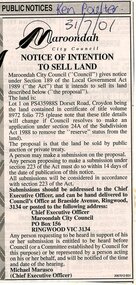
Newspaper, Public Notice of intention of Maroondah City Council to sell land in Dorset Road, (Lot 1 on P54359885), Croydon, 31 July 2001
... Public Notice of intention of Maroondah City Council to sell land in Dorset Road, (Lot 1 on P54359885), Croydon, 31 July 2001...Handwritten inscription in black ink below the above - 31/7/01 Newspaper extract with handwritten inscription on top Public Notice of intention of Maroondah City Council to sell land in Dorset Road, (Lot 1 on P54359885), Croydon, 31 July 2001 Newspaper ...Newspaper extract with handwritten inscription on top1. Handwritten inscription on top of article in blue ink "Ken Poulter" 2. Handwritten inscription in black ink below the above - 31/7/01 -
 Eltham District Historical Society Inc
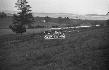
Photograph, George Burton Coop, The Royal Train enroute to Lilydale, near Croydon, 6 Mar. 1954
... Believed to have been taken bewteen Croydon Railway Station and the Dorset Road bridge. Taken late afternnon by George Coop's father. ...Believed to have been taken bewteen Croydon Railway Station and the Dorset Road bridge. Taken late afternnon by George Coop's father. ...Believed to have been taken bewteen Croydon Railway Station and the Dorset Road bridge. Taken late afternnon by George Coop's father. There is a Landrover parked on the grass with a person standing on it - believed to be Security. George recalls originally being located closer to the fence and being ushered up the hill where it was 'safer' to stand. In 1954 at age 27, Queen Elizabeth II was the first reigning British monarch to visit Australia.. She visited Victoria between March 1-10. Where to see the Queen (1954, January 21). Fern Tree Gully and District Times (Boronia, Vic. : 1953-1954), p. 5. Retrieved October 25, 2021, from http://nla.gov.au/nla.news-article264220429 “The Lilydale Shire President, Cr. Burgi, stated that the Royal train en route for Warburton on Saturday, March 6th, would slow down at Croydon and Lilydale. There was little possibility that it would stop at either of these towns. The train would pass through Lilydale at 5.52 p.m. Council had appointed a sub-committee to arrange matters, and had allocated £400 towards expenses. It was suggested that the train slow down between the railway station and Dorset Rd. bridge at Croydon, and between the Cave Hill Quarry and railway station at Lilydale.” An album of images of the Queen's visit to Victoria is available on the PROV Flickr account at https://www.flickr.com/photos/public-record-office-victoria/7252885616Digital TIFF file Scan of Kopdak 620 black and white negative transparencygeorge coop collection, croydon, royal train -
 Eltham District Historical Society Inc
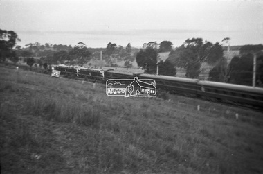
Photograph, George Burton Coop, The Royal Train enroute to Lilydale, near Croydon, 6 Mar. 1954
... Believed to have been taken bewteen Croydon Railway Station and the Dorset Road bridge. Taken late afternnon by George Coop's father. ...Believed to have been taken bewteen Croydon Railway Station and the Dorset Road bridge. Taken late afternnon by George Coop's father. ...Believed to have been taken bewteen Croydon Railway Station and the Dorset Road bridge. Taken late afternnon by George Coop's father. There is a Landrover parked on the grass with a person standing on it - believed to be Security. George recalls originally being located closer to the fence and being ushered up the hill where it was 'safer' to stand. In 1954 at age 27, Queen Elizabeth II was the first reigning British monarch to visit Australia.. She visited Victoria between March 1-10. Where to see the Queen (1954, January 21). Fern Tree Gully and District Times (Boronia, Vic. : 1953-1954), p. 5. Retrieved October 25, 2021, from http://nla.gov.au/nla.news-article264220429 “The Lilydale Shire President, Cr. Burgi, stated that the Royal train en route for Warburton on Saturday, March 6th, would slow down at Croydon and Lilydale. There was little possibility that it would stop at either of these towns. The train would pass through Lilydale at 5.52 p.m. Council had appointed a sub-committee to arrange matters, and had allocated £400 towards expenses. It was suggested that the train slow down between the railway station and Dorset Rd. bridge at Croydon, and between the Cave Hill Quarry and railway station at Lilydale.” An album of images of the Queen's visit to Victoria is available on the PROV Flickr account at https://www.flickr.com/photos/public-record-office-victoria/7252885616Digital TIFF file Scan of Kopdak 620 black and white negative transparencygeorge coop collection, croydon, royal train -
 Eltham District Historical Society Inc
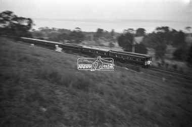
Photograph, George Burton Coop, The Royal Train enroute to Lilydale, near Croydon, 6 Mar. 1954
... Believed to have been taken bewteen Croydon Railway Station and the Dorset Road bridge. Taken late afternnon by George Coop's father. ...Believed to have been taken bewteen Croydon Railway Station and the Dorset Road bridge. Taken late afternnon by George Coop's father. ...Believed to have been taken bewteen Croydon Railway Station and the Dorset Road bridge. Taken late afternnon by George Coop's father. There is a Landrover parked on the grass with a person standing on it - believed to be Security. George recalls originally being located closer to the fence and being ushered up the hill where it was 'safer' to stand. In 1954 at age 27, Queen Elizabeth II was the first reigning British monarch to visit Australia.. She visited Victoria between March 1-10. Where to see the Queen (1954, January 21). Fern Tree Gully and District Times (Boronia, Vic. : 1953-1954), p. 5. Retrieved October 25, 2021, from http://nla.gov.au/nla.news-article264220429 “The Lilydale Shire President, Cr. Burgi, stated that the Royal train en route for Warburton on Saturday, March 6th, would slow down at Croydon and Lilydale. There was little possibility that it would stop at either of these towns. The train would pass through Lilydale at 5.52 p.m. Council had appointed a sub-committee to arrange matters, and had allocated £400 towards expenses. It was suggested that the train slow down between the railway station and Dorset Rd. bridge at Croydon, and between the Cave Hill Quarry and railway station at Lilydale.” An album of images of the Queen's visit to Victoria is available on the PROV Flickr account at https://www.flickr.com/photos/public-record-office-victoria/7252885616Digital TIFF file Scan of Kopdak 620 black and white negative transparencygeorge coop collection, croydon, royal train -
 Ringwood and District Historical Society
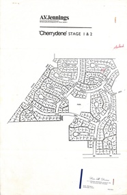
Flyer, Land Sale Advertisement - Cherrydene Estate, Stage 1 & 2, Ringwood, Vic. - 1969
... Dorset. Subdivison map of Cherrydene Estate and double-sided A4 size House & Land price list dated 27/10/1969. Developer - A.V. Jennings Industries (Aust) Ltd., Cnr. Springvale & Wellington Rds., Mulgrave, Vic. Phone 560 8411. Sales Dept. Rep., Leon B. Devine, Phone 560 8411 A/H.435 5311. Subdivision includes Wonga Road ...Subdivison map of Cherrydene Estate and double-sided A4 size House & Land price list dated 27/10/1969. Developer - A.V. Jennings Industries (Aust) Ltd., Cnr. Springvale & Wellington Rds., Mulgrave, Vic. Phone 560 8411. Sales Dept. Rep., Leon B. Devine, Phone 560 8411 A/H.435 5311. Subdivision includes Wonga Road, Holyrood Crescent, Clipper Court, Ripley Court, Harwick Close, Bader Court, Towerhill Drive, Nigel Court, Berkley Road, Avis Court, Carmen Close, Frederic Drive, Kenwood Crescent, Adele Court, Marilyn Street, Abbey Court, Baron Court, Kismet Close, Oban Road, Ringwood.Furnished and landscaped display homes are open for your inspection, (see map on reverse side) from 11 a.m. to 5 p.m. Sundays and Holidays, and 2 p.m. to 5 p.m. weekdays and Saturdays. Display homes list for 'Cherrydene' Ringwood - Arundel, Ashmoor, Avalon, Cleveland, Chiltern, Dorset. -
Eltham District Historical Society Inc
Document - Sharp family
... Road...Carrie Sharp...Sharps house Hurstbridge...Dorset...Gwen Sharp Sharp's Flat Hurstbridge Sharps Road Hurstbridge Arthurs Creek Hurstbridge Hurst Private Memorial Grave site Robert Hurst Frances Hurst Hurst's Bridge Ellen Hurst Keith Sharp Sheila Ferguson Henry Facey Hurst Charles Botterell Hawkins Fanny Hawkins nee Hurst Caroline Frances Maria Sharp nee Hawkins Robert Nehemiah Sharp "The Oaks" Kinglake William Sharp Edgar Sharp Harry Sharp Stan Sharp Daisy Sharp "Homeleigh" Hurstbridge Roy Sharp Jean Sharp Lilian Sharp Allwood House Hurstbridge Ferguson's Paddock Hurstbridge Arthur's Creek Road Carrie Sharp Sharps house Hurstbridge Dorset house Hurstbridge Ryans butcher Hurstbdirge Hortons bakery Hurstbridge Bootmaker Hurstbridge D G Graham blacksmith Hurstbridge Noella Macperson nee Sharp Richard Sharp Robert Sharp Muriel Sharp edna Sharp Lyn Sharp Muriel Sharp nee Limmer Muriel Willson Henry Willson Country Fire Authority Hurstbridge Newspaper clippings, A4 photocopies, etc Document Sharp family ...Keith Sharp was a descendant of the Hurst family, and lived in Hurstbridge, being active in the Hurstbridge Country Fire Authority. His family's farm gave its name to Sharps road, Hurstbridge. Contents Gwen Sharp, no date: Photocopy of collection of material on Sharp family of Hurstbridge and naming of Sharps Road containing: Photograph Fergusen's paddock, Hurstbridge, 1987. Notes on renaming of Sharp's Flat to Sharps Road. Notes on the Hurst family and how Keith Sharp is descended from Ellen Hurst, with details of each generation. Photographs of Sharp family and of Hurstbridge. Photograph of Allwood House, 1899, including W G Gray, Carrie Sharp and Robert Sharp. Newspaper clippings, A4 photocopies, etcgwen sharp, sharp's flat hurstbridge, sharps road hurstbridge, arthurs creek, hurstbridge, hurst private memorial grave site, robert hurst, frances hurst, hurst's bridge, ellen hurst, keith sharp, sheila ferguson, henry facey hurst, charles botterell hawkins, fanny hawkins nee hurst, caroline frances maria sharp nee hawkins, robert nehemiah sharp, "the oaks" kinglake, william sharp, edgar sharp, harry sharp, stan sharp, daisy sharp, "homeleigh" hurstbridge, roy sharp, jean sharp, lilian sharp, allwood house hurstbridge, ferguson's paddock hurstbridge, arthur's creek road, carrie sharp, sharps house hurstbridge, dorset house hurstbridge, ryans butcher hurstbdirge, hortons bakery hurstbridge, bootmaker hurstbridge, d g graham blacksmith hurstbridge, noella macperson nee sharp, richard sharp, robert sharp, muriel sharp, edna sharp, lyn sharp, muriel sharp nee limmer, muriel willson, henry willson, country fire authority hurstbridge -
 Eltham District Historical Society Inc
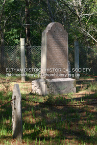
Photograph - Digital Photograph, Alan King, Henry Hurst grave, 1 February 2008
... His tragic end is recounted on his tombstone at the Hurst family cemetery, by Greysharps Road off Arthurs Creek Road erected ‘by a grateful public as a memorial to his heroic self-sacrifice.’ The memorial reads, ‘Sacred to the memory of Henry Facey Hurst (formerly of Hanford Dorset) who while defending his home fell near this spot by a ball fired by the bushranger Burke on October 4 1866 aged 34 years’. ...His tragic end is recounted on his tombstone at the Hurst family cemetery, by Greysharps Road off Arthurs Creek Road erected ‘by a grateful public as a memorial to his heroic self-sacrifice.’ The memorial reads, ‘Sacred to the memory of Henry Facey Hurst (formerly of Hanford Dorset) who while defending his home fell near this spot by a ball fired by the bushranger Burke on October 4 1866 aged 34 years’. ...Henry Hurst, after whom Hurstbridge was named, had a hard and adventurous life in the raw colony of the mid 1800s. His tragic end is recounted on his tombstone at the Hurst family cemetery, by Greysharps Road off Arthurs Creek Road erected ‘by a grateful public as a memorial to his heroic self-sacrifice.’ The memorial reads, ‘Sacred to the memory of Henry Facey Hurst (formerly of Hanford Dorset) who while defending his home fell near this spot by a ball fired by the bushranger Burke on October 4 1866 aged 34 years’. Published: Nillumbik Now and Then / Marguerite Marshall 2008; photographs Alan King with Marguerite Marshall.; p15This collection of almost 130 photos about places and people within the Shire of Nillumbik, an urban and rural municipality in Melbourne's north, contributes to an understanding of the history of the Shire. Published in 2008 immediately prior to the Black Saturday bushfires of February 7, 2009, it documents sites that were impacted, and in some cases destroyed by the fires. It includes photographs taken especially for the publication, creating a unique time capsule representing the Shire in the early 21st century. It remains the most recent comprehenesive publication devoted to the Shire's history connecting local residents to the past. nillumbik now and then (marshall-king) collection, hurst family cemetery, hurstbridge, gravestones, henry hurst, memorial -
 Eltham District Historical Society Inc
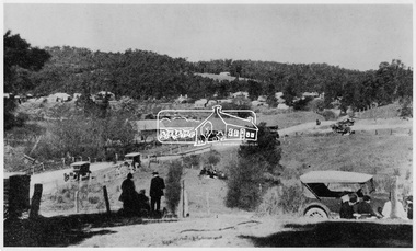
Negative - Photograph, Popular Picnicing at Hurstbridge, c.1925
... dorset house...fawkner crescent...haleys gully road...It is believed the picture is taken at the northwest corner of the intersection of Wattletree Road and Hurstbridge-Arthurs Creek Road looking southeast towards the township (most likely where the house is located on the property of what is today No. 2 Wattletree Road)- https://goo.gl/maps/VDorwCe1rJJUapjE6 According to a comment by Jean Verso (via @nillumbikcouncil FB page 3 Jan 2020) - "This view is from Wattle Tree Road with Haleys Gully Road to the right and across the creek to William Gray's nursery at Allwood. The building to the far left looks like Dorset House. ...It is believed the picture is taken at the northwest corner of the intersection of Wattletree Road and Hurstbridge-Arthurs Creek Road looking southeast towards the township (most likely where the house is located on the property of what is today No. 2 Wattletree Road)- https://goo.gl/maps/VDorwCe1rJJUapjE6 According to a comment by Jean Verso (via @nillumbikcouncil FB page 3 Jan 2020) - "This view is from Wattle Tree Road with Haleys Gully Road to the right and across the creek to William Gray's nursery at Allwood. The building to the far left looks like Dorset House. ...Picnickers enjoying a Sunday outing near the Wattle Valley Estate at Hurstbridge. Copied from brochure "Wattle Valley Estate". It is believed the picture is taken at the northwest corner of the intersection of Wattletree Road and Hurstbridge-Arthurs Creek Road looking southeast towards the township (most likely where the house is located on the property of what is today No. 2 Wattletree Road)- https://goo.gl/maps/VDorwCe1rJJUapjE6 According to a comment by Jean Verso (via @nillumbikcouncil FB page 3 Jan 2020) - "This view is from Wattle Tree Road with Haleys Gully Road to the right and across the creek to William Gray's nursery at Allwood. The building to the far left looks like Dorset House. The building on the left in the middle distance is still there today and has been used for storage and as a stable/tack room for a number of years." The Wattle Valley Estate was first advertised in August 1925 as weekend building allotments by the Greater Melbourne Land and Development Company. Advertised from £28.10.0 or £60 per block. In August 1926, 30 picked allotments of 60x150 feet were put up for auction Saturday August 14, 1926 with frontages to Valley View Road and Fawkner Crescent advertised in the “Heart of the Glorious Wattle Country” and “Within 15 Minutes of the Newly Electrified Railway Station”. The Advertiser on August 13, 1926 in an article promoting the auction stated “the estate is regarded as one of the best in the district, and will be sold practically without reserve.” It is noted that an advertisement running in The Argus February 22, 1951 offered the remaining 16 blocks for sale at £12.10.0 or £200 the lot. By March 7, the remaining blocks were advertised at £17.10.0 The Wattle Valley Estate took over 20 years to sell and then people could not build on them Cross Ref EDHS_02665 Rose Series Postcard P. 4341, "View at Hurstbridge, Vic." Also, other images from sales brochure SEPP_1055 / 1056This photo forms part of a collection of photographs gathered by the Shire of Eltham for their centenary project book,"Pioneers and Painters: 100 years of the Shire of Eltham" by Alan Marshall (1971). The collection of over 500 images is held in partnership between Eltham District Historical Society and Yarra Plenty Regional Library (Eltham Library) and is now formally known as the 'The Shire of Eltham Pioneers Photograph Collection.' It is significant in being the first community sourced collection representing the places and people of the Shire's first one hundred years.Digital image 4 x 5 inch B&W Neg1925, dorset house, fawkner crescent, haleys gully road, hurstbridge, hurstbridge-arthurs creek road, picnic, postcards, shire of eltham pioneers photograph collection, valley view road, wattle valley estate, wattletree road, exhibition yprl 2019-12 -
 Eltham District Historical Society Inc
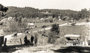
Photograph - Postcard, Rose Stereograph Company, View at Hurstbridge, Vic, c.1925
... Dorset House...Exhibition YPRL 2019-12...Fawkner Crescent...Haleys Gully Road...It is believed the picture is taken at the northwest corner of the intersection of Wattletree Road and Hurstbridge-Arthurs Creek Road looking southeast towards the township (most likely where the house is located on the property of what is today No. 2 Wattletree Road)- https://goo.gl/maps/VDorwCe1rJJUapjE6 According to a comment by Jean Verso (via @nillumbikcouncil FB page 3 Jan 2020) - "This view is from Wattle Tree Road with Haleys Gully Road to the right and across the creek to William Gray's nursery at Allwood. The building to the far left looks like Dorset House. ...It is believed the picture is taken at the northwest corner of the intersection of Wattletree Road and Hurstbridge-Arthurs Creek Road looking southeast towards the township (most likely where the house is located on the property of what is today No. 2 Wattletree Road)- https://goo.gl/maps/VDorwCe1rJJUapjE6 According to a comment by Jean Verso (via @nillumbikcouncil FB page 3 Jan 2020) - "This view is from Wattle Tree Road with Haleys Gully Road to the right and across the creek to William Gray's nursery at Allwood. The building to the far left looks like Dorset House. ...Rose Series Postcard P. 4341 “View at Hurstbridge, Vic.” Picnickers enjoying a Sunday outing near the Wattle Valley Estate at Hurstbridge. Copied from brochure "Wattle Valley Estate". It is believed the picture is taken at the northwest corner of the intersection of Wattletree Road and Hurstbridge-Arthurs Creek Road looking southeast towards the township (most likely where the house is located on the property of what is today No. 2 Wattletree Road)- https://goo.gl/maps/VDorwCe1rJJUapjE6 According to a comment by Jean Verso (via @nillumbikcouncil FB page 3 Jan 2020) - "This view is from Wattle Tree Road with Haleys Gully Road to the right and across the creek to William Gray's nursery at Allwood. The building to the far left looks like Dorset House. The building on the left in the middle distance is still there today and has been used for storage and as a stable/tack room for a number of years." The Wattle Valley Estate was first advertised in August 1925 as weekend building allotments by the Greater Melbourne Land and Development Company. Advertised from £28.10.0 or £60 per block. In August 1926, 30 picked allotments of 60x150 feet were put up for auction Saturday August 14, 1926 with frontages to Valley View Road and Fawkner Crescent advertised in the “Heart of the Glorious Wattle Country” and “Within 15 Minutes of the Newly Electrified Railway Station”. The Advertiser on August 13, 1926 in an article promoting the auction stated “the estate is regarded as one of the best in the district, and will be sold practically without reserve.” It is noted that an advertisement running in The Argus February 22, 1951 offered the remaining 16 blocks for sale at £12.10.0 or £200 the lot. By March 7, the remaining blocks were advertised at £17.10.0 The Wattle Valley Estate took over 20 years to sell and then people could not build on them Cross Ref SEPP_1057, “Popular Picnicing at Hurstbridge” rcopied from Wattle Valley estate sales brochure.Digital file only Postcards scanned from the collection of Michael Aitken on loan to EDHS, 13 Feb 20181925, dorset house, exhibition yprl 2019-12, fawkner crescent, haleys gully road, hurstbridge, hurstbridge-arthurs creek road, michael aitken collection, picnic, postcards, rose stereograph company, shire of eltham pioneers photograph collection, valley view road, wattle valley estate, wattletree road
