
Showing 11 items matching "drains mill"
-
 Marysville & District Historical Society
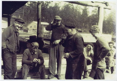
Photograph (item) - Black and white photograph, The original photograph was taken between 1950 and 1960
... ...drains mill...'Smoko at Goulds Sawmill (originally Drains Mill)/ Government road (Sunds road) Marysville/ c.1950-1960 Background - House on left Allan and Shirley Sund's/ home. ...A copy of a black and white photograph taken at 'smoko' at Goulds Sawmill in Marysville. marysville victoria australia j.l. gould sawmills pty. ltd. drains mill photograph 'Smoko at Goulds Sawmill (originally Drains Mill)/ Government road (Sunds road) Marysville/ c.1950-1960 Background - House on left Allan and Shirley Sund's/ home. ...A copy of a black and white photograph taken at 'smoko' at Goulds Sawmill in Marysville. The original photograph was taken in 1950-1960 and shows a group of men standing around enjoying their smoko break.A copy of a black and white photograph taken at 'smoko' at Goulds Sawmill in Marysville.'Smoko at Goulds Sawmill (originally Drains Mill)/ Government road (Sunds road) Marysville/ c.1950-1960 Background - House on left Allan and Shirley Sund's/ home. House on right Chook and/ Lea Hope's home L to RP: Len West, Claude Ratcliffe,/ Bruce 'Nugget' Webb, John Whiteley,/ ?, 'Obee' O'Brien, ?marysville, victoria, australia, j.l. gould sawmills pty. ltd., drains mill, photograph -
 Flagstaff Hill Maritime Museum and Village
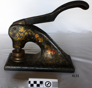
Functional object - Hand operated embossing document press, 1910
... Thereafter, government orders for cloth and military supplies assured the mill’s success right through the First World War and on until 1923. A plant upgrade in 1922 for machinery to make worsted fabric drained profits, which, with a fall in demand, led to a loss in 1925. ...Thereafter, government orders for cloth and military supplies assured the mill’s success right through the First World War and on until 1923. A plant upgrade in 1922 for machinery to make worsted fabric drained profits, which, with a fall in demand, led to a loss in 1925. ...The woollen mill was a vital part of Warrnambool for all but 22 years of the town’s history since it's the establishment in 1847 when the first land sales were held and white settlement began. In 1869 the Warrnambool Meat Preserving Company began operations on the mill site, in 1875, shareholders of the then defunct Warrnambool Meat Preserving Company happily sold the land and buildings on the Merri river to Warrnambool Woollen Mill Company Ltd for £5,000. The site was sold again in 1876 to grazer Robert Hood of Sherwood, who was chairman of directors of the failed company, which couldn’t raise sufficient capital to keep the works operating. The entrepreneurial Hood then used the existing plant to turn his own wool into tweed cloth. But just as the mill was starting to show a profit, a fire destroyed the building and plant on the night of 25 March 1882. So again, the mill was operational for six short years. Insurers only paid a fraction over 10% of the damage, Hood couldn't raise sufficient capital to rebuild on his own, and so the site lay unused until 1910. In 1908 Marcus Saltau and Peter John McGennan convinced the Warrnambool Chamber of Commerce to invest in a secondary industry with local capital. A public meeting in September 1908 agreed to raise £40,000, electing Saltau chairman of directors, a post he held for 34 years. A year later, using mostly local money, the Warrnambool Woollen Mill Company dispatched its first manager, John E. Bennett, to buy a plant and recruit 20 experienced staff from the Yorkshire woollen industry in December 1909. Another year more, the new mill was officially opened on 14 November 1910 by Marcus Saltau as company chairman and town mayor. Eighteen months on, in May 1912, the mill paid its first half-yearly dividend of 2 ½%. It was now working two shifts, with a year's orders to fill. In 1914 the mill ordered its own generator, providing the town with electricity and effectively doubling its plant size by October 1915, six months after Gallipoli. Thereafter, government orders for cloth and military supplies assured the mill’s success right through the First World War and on until 1923. A plant upgrade in 1922 for machinery to make worsted fabric drained profits, which, with a fall in demand, led to a loss in 1925. Profits were restored by the 1930s, despite the Depression, mostly due to tight management and robust marketing. Production boomed again during the Second World War, but soon foreign competition bit into profits, forcing the company to consolidate operations. The ‘50s and ‘60s were golden years for the mill. Security and growth gave the company confidence to trial Australia’s first electric blanket in 1958 and to install Swiss Sulzer looms in 1965. Over time, the building facades took on the modern look that the mill presented until it closed. The Dunlop company bought the mill in 1968, fending off a challenge from Onkaparinga in South Australia, and continued to expand by adding Wendouree Woollen Mill in the same year and Dream-spun Textiles a decade later, in 1979. Soon after that purchase, however, the mill began its slippery slide into decline. Dunlop sold to its former rival bidder Onkaparinga Woollen Co. Ltd in 1982, which in turn was taken over by Macquarie Worsted's only a year later, in 1983. Operations remained stable for a decade until 1994 when the Macquarie Group signaled that its newly rationalised operations left no room for the Warrnambool investment. The final operator of the mill was The Smith Family charity group, which ran the site by agreement with the Warrnambool City Council and a state government grant in that same year, 1994. The mill became more of a fabric recycler than a manufacturer. The site was sold to private operators in February 2003 and rezoned four months later to allow for the mixed housing development. The embossing press is significant for its association with the Warrnambool Woollen Mills 1910-1968, a major employer in the Warrnambool district. The press is also significant as an example of commercial office equipment used in the 19th and 20th century.Press, metal, for Company seal of Warrnambool Woollen Mill, stamping their brand as Western District Worsted Mills Pty Ltd. Metal is black with red and gold floral markings. Inscription of stamp reads "WESTERN DISTRICT WORSTED MILLS PROPRIETRY LIMITED" flagstaff hill, warrnambool, shipwrecked-coast, flagstaff-hill, flagstaff-hill-maritime-museum, maritime-museum, warrnambool woollen mills, western district worsted mills proprietry limited, worsted fabric, printing press, logo printing press, stamp printing press, shipwreck-coast, flagstaff-hill-maritime-village -
 Federation University Historical Collection
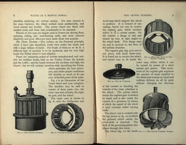
Book, Machinery for Metalliferous Mines, 1894, 1894
... Chapters include Water as a motive power, Wind engines and ventilating machinery, Steam boilers/engines and oil engines, hoisting machinery, draining of Mines, pumping engines, rock drilling machinery, boring machinery, concentration machinery, sizing and classifications trommels, joggers and jigging, fine concentration, milling of gold ores, milling of silver ores, amalgamation plates and machinery, dry and roasting machinery, chlorination and cyandide processes for the extraction of gold, electricity as a motive power for mining, electric lighting and blasting, aerial wire ropeways, transport by rail and road. ...It covers a wide range of equipment - pumps, steam engines, drills, winding engines, stamps & concentration mills, aerial ropeways, tramways and early uses of electricity etc. mining cornish pump linkenbach table water wheel ventilation oil engine california america water steam boilers steam engines oil engines pumpimg rock drilling boring jiggers milling silver gold drying and roasting chlorination cyaniding lead zinc copper electricity electric lighting wire ropes transport wind engine poppet head Brown hard cloth covered book. xvi 564 pages with additional advertisements, with over 300 illustrations and drawings, some fold out. Chapters include Water as a motive power, Wind engines and ventilating machinery, Steam boilers/engines and oil engines, hoisting machinery, draining ...The 1st edition of this famous work, giving an excellent account of the machinery used in late 19th century metal mining in the UK and overseas is very rare. It covers a wide range of equipment - pumps, steam engines, drills, winding engines, stamps & concentration mills, aerial ropeways, tramways and early uses of electricity etc. Brown hard cloth covered book. xvi 564 pages with additional advertisements, with over 300 illustrations and drawings, some fold out. Chapters include Water as a motive power, Wind engines and ventilating machinery, Steam boilers/engines and oil engines, hoisting machinery, draining of Mines, pumping engines, rock drilling machinery, boring machinery, concentration machinery, sizing and classifications trommels, joggers and jigging, fine concentration, milling of gold ores, milling of silver ores, amalgamation plates and machinery, dry and roasting machinery, chlorination and cyandide processes for the extraction of gold, electricity as a motive power for mining, electric lighting and blasting, aerial wire ropeways, transport by rail and road. There a a number of lovely line illustrations in the book including: Poncelot's undershot waterwheel; Fromont furnace;Victor turbine; Pelton waterwheel; Root's positive blower;Cross section and front elevation of Lancashire boiler; Robey's Compound Mill Engine; Portable Winding Plant; Iron Pit Head Gear ; Loading Arrangement in an Incline Shaft; kibble; Worthington Pump; California Pump; Scram's Air Compressor; Rock drill Bits; Special Sharpening tools; Boring tools;Rotating Picking table; Ore Feeder; roller crusher; stamp battery; round buddle; slime table; vanner; amalgamating plant; belt elevator;roasting furnace;splicing wire rope; capel; tipping waggon;mining, cornish pump, linkenbach table, water wheel, ventilation, oil engine, california, america, water, steam boilers, steam engines, oil engines, pumpimg, rock drilling, boring, jiggers, milling, silver, gold, drying and roasting, chlorination, cyaniding, lead, zinc, copper, electricity, electric lighting, wire ropes, transport, wind engine, poppet head -
 Marysville & District Historical Society
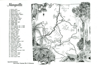
Map (item) - Sawmill locations, Ann Thomas, Unknown
... A map with a key showing the locations of the many timber mills in the district surrounding Marysville. marysville victoria australia sawmill sawmill locations map knot's marchbank diver's burt & timms nobel-anderson herman don lovett little wonder feiglin cambarville a.e. anderson ratcliffe w.m. cook j. sund drain's stebbins vic oak jack elliott howell's ron bassett tony miller cameron & barton flatman's victor yelland ernie peake robinson bros paget bromfield & gorman menz jack arnold lee archer A map with a key showing the locations of the many timber mills in the district surrounding Marysville. ...A map with a key showing the locations of the many timber mills in the district surrounding Marysville.A map with a key showing the locations of the many timber mills in the district surrounding Marysville.marysville, victoria, australia, sawmill, sawmill locations, map, knot's, marchbank, diver's, burt & timms, nobel-anderson, herman, don lovett, little wonder, feiglin, cambarville, a.e. anderson, ratcliffe, w.m. cook, j. sund, drain's, stebbins, vic oak, jack elliott, howell's, ron bassett, tony miller, cameron & barton, flatman's, victor yelland, ernie peake, robinson bros, paget, bromfield & gorman, menz, jack arnold, lee archer -
 City of Whittlesea
Document - Correspondence, Council letter to Mrs Moses Thomas 1868, 1878
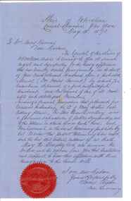
... drains. Road District Boards were one of the earliest forms of local government in Victoria. The Morang or Upper Plenty Road District was established in 1862. It covered part of what is today Mernda, Doreen, South Morang, Mill...drains. Road District Boards were one of the earliest forms of local government in Victoria. The Morang or Upper Plenty Road District was established in 1862. It covered part of what is today Mernda, Doreen, South Morang, Mill ...In 1851 Moses Thomas purchased 400 acres, including a half mile frontage to the Plenty River, at Mernda (then known as Morang) where he operated a farm, inn and other business. In 1865 Moses Thomas was appointed Engineer, Clerk and Collector for the Morang District Road Board. In this role he would have been responsible for overseeing the collection of local property rates and the maintenance and construction of local roads and drains. Road District Boards were one of the earliest forms of local government in Victoria. The Morang or Upper Plenty Road District was established in 1862. It covered part of what is today Mernda, Doreen, South Morang, Mill Park and Bundoora. In 1875, the area merged with the Whittlesea Road District to form the Shire of Whittlesea. Moses Thomas briefly served as a Councillor with the Shire of Whittlesea until his death in 1878. Correspondence. Letter, paper, handwritten text with seal. Letter from James Ryan, Shire Secretary, Shire of Whittlesea to Mrs Moses Thomas on the death of Moses 18 May 1878. -
 Stawell Historical Society Inc
Photograph - Aunde Album 29, Dye Lab - Creating the Dye Mix, 2002
... Aunde / Norwellan Textiles North Western Woollen Mills became Norwellan Textiles then AUNDE Industry Aunde AUnde Australia Ltd. logo Colour landscape photo: Dyer in lab coat using glassware to mix dye. Open cupboard with dyes Glassware racked above sink, glassware draining ...Aunde / Norwellan Textiles North Western Woollen Mills became Norwellan Textiles then AUNDEColour landscape photo: Dyer in lab coat using glassware to mix dye. Open cupboard with dyes Glassware racked above sink, glassware drainingAUnde Australia Ltd. logoindustry, aunde -
 National Wool Museum
Machine - Scouring Bowl, J Dyson & Sons Pty Ltd, c.1890
... drain into rivers and watercourses causing pollution. Many of Geelong's wool scours along the Barwon River were closed due to environmental damage. The race system on this bowl is not the original it has been modified with a variation of the harrow system. Used at E.P. Robinson South Geelong from c.1890-1970. Souring Bowl J Dyson & Sons Geelong Wool processing E. P. Robinson Textile Industry Factory Mill ...Scouring is the process that removes wool wax and other unwanted products from wool. Wool is washed in a hot detergent solution. It moves through a series of scouring bowls and is then rinsed and dried. Careful handling and washing preserves the strength and softness of wool. If the wool contains lots of seeds and other vegetable matter, it must be cabonized. This means it is treated with a solution of sulpheric acid and then baked at high temperature to remove impurities. The disused scouring water left-over from this process was often let drain into rivers and watercourses causing pollution. Many of Geelong's wool scours along the Barwon River were closed due to environmental damage. The race system on this bowl is not the original it has been modified with a variation of the harrow system. Used at E.P. Robinson South Geelong from c.1890-1970.Scouring bowl.J. Dyson & Sons Pty Ltd, Geelongsouring bowl, j dyson & sons, geelong, wool processing, e. p. robinson, textile industry, factory, mill -
 Kilmore Historical Society
Photograph, Colonial Bank of Australasia, 1883
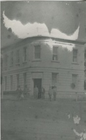
... drain covered with a grating, with the tunnel going across the road diagonally, Kids used to walk under it. The window panes on the corner were curved, as was the door." 2.10/86 Colonial bank of Australia Cnr Lancefield Rd. & Powlett St. C. 1883 (bank oved to opposite Mill...drain covered with a grating, with the tunnel going across the road diagonally, Kids used to walk under it. The window panes on the corner were curved, as was the door." 2.10/86 Colonial bank of Australia Cnr Lancefield Rd. & Powlett St. C. 1883 (bank oved to opposite Mill ...Donated by Dan Clancy. 1 Powlett Street, Kilmore, Mitchell Shire , Victoria, Australia10cm x 20cm black and white photograph of 1 Powlett street, former colonial bank of Australasia. Corner of Powlett Street and Lancefield Road, Kilmore. Reproduction on standard photographic paper, possibly because of damage seen in the reproduction. The image has a low contrast possibly from incorrect development or other damage. Two story light coloured rendered building with blue stone street curbing. Seven figures stand outside of the building, six men and one child. The photograph was take around 1883 and reproduced in 1986.Printed on the back: 104/2.6 200486/2 Colonial Bank of Australia - cnr Powlett & Lancefield Rd. Kilmore Historical Society "In front of this Hotel was a weigh-bridge there was big drain covered with a grating, with the tunnel going across the road diagonally, Kids used to walk under it. The window panes on the corner were curved, as was the door." 2.10/86 Colonial bank of Australia Cnr Lancefield Rd. & Powlett St. C. 1883 (bank oved to opposite Mill St. on that date.) Dan Clancy Collection.hotels, 19th century -
 Department of Energy, Environment and Climate Action
Pulpwood billet hook
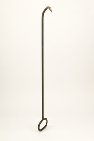
... Billets were first stacked endwise to drain the sap and lighten the load before they were loaded by hand onto flat bed trucks for transport to the mills. ...Billets were first stacked endwise to drain the sap and lighten the load before they were loaded by hand onto flat bed trucks for transport to the mills. ...Pulpwood was often split by hand or with black powder splitting guns into more manageable sizes and cut into 8 foot lengths (or billets). Billets were first stacked endwise to drain the sap and lighten the load before they were loaded by hand onto flat bed trucks for transport to the mills. This long length metal hook was used to pull and manoeuvre the pulpwood billets onto the truck. The advent of excavators in logging operations in the 1970s led to the loading and carting pulpwood in long tree lengths.Long steel tool with handle on one end and hook on the other. -
 Sunshine and District Historical Society Incorporated
Photograph - Albion Houses - Old and New, Albion Houses
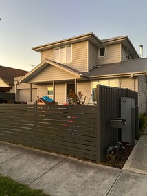
... As of 2013, the creek's environmental state west of Anderson Road is very poor as it has long been converted to nothing more than a concrete stormwater drain for this particular section of its course. A notable landmark of Albion is the red brick John Darling and Son Flour Mill built in 1922. ...Albion is a suburb in Melbourne, Victoria, Australia, 14 km (8.7 mi) west of Melbourne's Central Business District, located within the City of Brimbank local government area. Albion recorded a population of 4,334 at the 2021 census. Albion is bordered on the north by Ballarat Road, the south by Forrest Street, the west by Kororoit Creek and the east by Anderson Road. The suburb is completely surrounded by other parts of Sunshine except for Ardeer, which lies to Albion's due west across Kororoit Creek.History - The area was originally called Darlington, from at least 1860 to about 1890. The area originally known as Albion was directly west of Duke Street, as can be noted by the many streets there named after English counties and placenames – Albion being an ancient name for the island of Great Britain. Albion station opened on 5 January 1860 as Albion and Darlington but closed a year later. It was not until 1919 that a new station was opened on the same site with the name Albion station. In March 1885 the Albion Quarrying Company began its operations in the area. The disused Albion quarry, accessed from Hulett Street in Albion, was the location for AC/DC's Jailbreak music video. It was H. V. McKay of Sunshine Harvester Works fame who bought land to develop a residential community for his workers in first decades on the 20th century. His concept for Sunshine was the Sunshine Estate: a community designed with superficial similarities to garden cities of the early 20th century. This area was mainly in what is now called Albion. McKay's own residence, The Gables, was in Talmage Street (where the cul-de-sac The Gables now is) until it was consumed by fire and subsequently demolished. Today - Albion has many period homes such as California bungalows and 1940s weatherboard houses. In the eastern parts of Albion, many of the oldest homes were built by H. V. McKay as part of his Sunshine Estate, a housing community built according to the influential early 20th Century Garden city movement. Kororoit Creek provides the western border for Albion. Along it runs the Kororoit Creek Trail which runs all the way southwards to meet the Federation Trail in Brooklyn. Stony Creek lies on the eastern edge of Albion, close to Anderson Road. As of 2013, the creek's environmental state west of Anderson Road is very poor as it has long been converted to nothing more than a concrete stormwater drain for this particular section of its course. A notable landmark of Albion is the red brick John Darling and Son Flour Mill built in 1922. It is just to the south of Ballarat Road, next to Albion train station.7010.01 - 84 King Edward Avenue Albion Vic 3020 has a land size of 630m2. It is house with 2 bedrooms, 1 bathroom, and no parking space. It was sold in 2018 for $775,000 and leased for $330 per week by Jas Stephens Real Estate. In 2017 the house was leased for $320 per week. In 2011 it was sold for $353,000 by Redina Real Estate. In 2007 the house was sold for $327,000. Median Property prices in Albion over the last year range from $797,500 for houses. 7010.30 - 82 King Edward Avenue Albion Vic 3020 has a land size of 629m2. It is a house. Median property prices in Albion over the last year range from $797,500 for houses. 7010.40 - 34 King Edward Avenue Albion Vic 3020 has a land size of 259 m2 It is a house that was built in 1950 with 3 bedrooms, 1 bathroom, and no parking space. It was sold in 2012 for $285,000 by Douglas Kay Real Estate Sunshine. Median Property prices in Albion over the last year range from $797.500 for houses for $311,000 for units. Recent sale on 30th April 2012 for $285,000; Sold in on 4th April 2011 for $235,000; Sold 15th April 1996 $60,000; Sold 29th January 1994 $68,000; Sold on 27th August 1982 $20,700. Built in 1950. 7010.50 - 30 Perth Avenue, Albion has a land size of 698 m2. It is a house with 2 bedrooms, 1 bathroom and 1 parking space. It was sold in 2023 for $765,000 by Barry Plant – Sunshine. Median property prices in Albion over the last year range from $797,000 for houses. 7010.80 – 14B Perth Avenue Albion. The passion for excellence that is the signature attribute of any address built by NERO LIVING defines this freshly completed Hamptons influenced four bedroom, two bathroom home. Classically crisp external lines introduce faultlessly finished spaces including an airy, inviting lounge that can be flexibly formal or informal according to the occasion. To the rear, a refined yet relaxed living/dining area is kept beautifully bright by a series of superb Velux sky-lights while access to eco alfresco decking creates a seamlessly successful relationship between indoors and out. The kitchen is a showstopper: a perfect zone for exercising your culinary creativity complemented by the elegance efficiency of Hamptons inspired styling beneath beautiful racked ceilings, where a walk-in pantry and Smeg appliances including an induction cooktop, oven and integrated dishwasher make meeting modern day needs a breeze. Alluring accommodation is led by a luxurious main bedroom with a twin-vanity ensuite and shower with floor-to-ceiling tiles. Three additional robed bedrooms, a chic bathroom, and a powder room complete the ensemble. With double glazing, efficient laundry area, Daikin climate control heating/cooling, Bosch alarm, rainwater tank, and remote garage, with additional OSP this brilliant brand new residence is desirably positioned walking distance from Selwyn Park, the Perth Avenue café and shopping hub and Albion Primary School. A perfect property for enjoying Albion today's way. 27/7/2026 House price low range $680,000 and high range $810,000. The estimated rental income of 14 Perth Avenue is $425 based on our available property data. 14 Perth Avenue Albion Vic 3020 has a land size of 697 m2. It is a house with 2 bedrooms, 1 bathroom and 2 Parking spaces. I was sold in 2024 for $705,000 by One Agency Carlo Puglia Property. Median property prices in Albion over the last year range from $797,500 for houses to $300,000 for units. The house was sold before that on 5th September 1998 for $87,000. albion houses - old and new, albion houses - 82 king edward avenue, albion houses - 84 king edward avenue, 34 king edward avenue, 14 perth avenue, 30 perth avenue -
 Sunshine and District Historical Society Incorporated
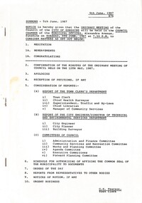
Administrative record - City of Sunshine Council Meetings 1986 - 1994 - Notice of Ordinary Meeting 9th June 1987, City of Sunshine, 5th June 1987
... Albans Children's Services Consultation Local Government and Community Development Conference 7th - 8th May 1987 Report Victorian Municipal Community Services Association 15th May 1987 Report Child Care Centre Peer Team Review Report Home and Community Care Program Ethnic Food Services Project Marie Mill Community Centre Advisory Committee Castley Hall Redevelopment Project Mini Budget 1987 Raising Funds for the Sunshine Community Nursing Home Report of the City Engineer Road Humps in the Right of Way Between Glendenning Street and McKechnie Street St. Albans Plans for the Construction of Road and Drains...Albans Children's Services Consultation Local Government and Community Development Conference 7th - 8th May 1987 Report Victorian Municipal Community Services Association 15th May 1987 Report Child Care Centre Peer Team Review Report Home and Community Care Program Ethnic Food Services Project Marie Mill Community Centre Advisory Committee Castley Hall Redevelopment Project Mini Budget 1987 Raising Funds for the Sunshine Community Nursing Home Report of the City Engineer Road Humps in the Right of Way Between Glendenning Street and McKechnie Street St. Albans Plans for the Construction of Road and Drains ...Notice of Ordinary Meeting 9th June 1987 Report of the Town Clerk's Department Report of the Town Clerk Accounts for Payment as at 15th May 1987 Sub Lease by Sunshine and District Helping Hands Darnley Street Sunshine to Minister for Education Proposed Compulsory Acquisition Part 66 Glengala Road for Proposed Roundabout Lease of Lots 1, 2 & 3 Forrest Street from State Transport Authority Cleaning Contract Unexpended Loan Funds Road Closure Part of the Road Reserve Van Ness Avenue Maribyrnong Proposed Discontinuance of the Right of Way Between Ballarat Road and Lawson Street Albion Proposed Closure of Roads Part of Navigator Street, Part of Right of Way Between Clyde Street, Navigator Street, The Esplanade and Chilfley Drive, The Right of Way Between Ensign Street and Chifley Drive Maribyrnong Ardeer South Primary School Finance Maintenance to House Located at the School Agreement Sunshine High School Use of School Playing Fields for Community Use Promotion of Council Events West Community Farm Project Returned Services League ANZAC Day Sunshine RSL St. Albans Community Health & Resource Centre Discontinued Right of Way Between Plantation Street, Newstead Street, The Esplanade & Chifley Drive Maribyrnong Sunshine Park Tennis Club Attempt to Break World Records for Non-Stop Tennis Request for Donation Arthritis Foundation of Victoria North Sunshine Cricket Club Requesting Use of Lloyd Reserve Sunshine / Keilor Liaison Committee May Economic Statement Local Government Bill Bon Thomas Reserve Development Report of the Chief Health Surveyor Registration of Premises Health Act & Food Act Transfer of Registration of Premises Prosecution Proceedings Sunshine Magistrates Court Albanvale Water Supply Report of the Superintendent Traffic & By-laws Dog Act Traffic and Parking Infringements Court Proceedings Parking Problems Tottenham Stores & Disposal Depot Beachley Street Braybrook Urgent Business Council Meeting 10th March 1987 Report of the Chief Librarian Workshop on Costing and Programme Budgeting for Public libraries Information for Local Government Decision Making Conference 3rd - 5th May 1987 Canberra Report Sale of Discarded Books Russian Cataloguing Public Library Funding Report of the Acting Manager Community Services St. Albans Multicultural Consultative Council Municipal Association of Victoria Housing Poster Additional Funds Under Supplementary Service Grant Protective Behaviors Training Rhodes Street Child Care Centre St. Albans Children's Services Consultation Local Government and Community Development Conference 7th - 8th May 1987 Report Victorian Municipal Community Services Association 15th May 1987 Report Child Care Centre Peer Team Review Report Home and Community Care Program Ethnic Food Services Project Marie Mill Community Centre Advisory Committee Castley Hall Redevelopment Project Mini Budget 1987 Raising Funds for the Sunshine Community Nursing Home Report of the City Engineer Road Humps in the Right of Way Between Glendenning Street and McKechnie Street St. Albans Plans for the Construction of Road and Drains for Stage 1 of the Subdivision of Industrial land at Sunshine Road Tottenham Western Highway (Ballarat Road) Right Turn Lane at Esmond Street Ardeer Western Highway (Ballarat Road) / Holt Street Ardeer Gas & Fuel Depot Site Exit Traffic Signal Installation Tenders Somers Street Sunshine North Private Street Scheme Tenders for the Purchase of New Plant Traffic Control Items Motion Garbage Disposal Metal Skips Intersection Sunshine Avenue / Main Road East St. Albans Report of the City Planner Planning Permit Application Flats 17 Gum Street Sunshine West Planning Permit Application Factory Lot 117 Davies Avenue Sunshine North Planning Permit Application Warehouse Lot 16 Central Avenue South East Corner First Avenue Sunshine Planning Permit Application Factory 146 McIntyre Road Sunshine North Planning Permit Application Four Flats 29 Bardsley Street Sunshine West Planning Permit Application Health Centre 115 Main Road West St. Albans Planning Permit Application Factory Lot 1 Reid Street Albion Planning Permit Application Dual occupancy 2 Langley Street Ardeer Planning Permit Application Car Sales Surrey Street Sunshine North Planning Permit Application Extended Trading Hours Highpoint City Shopping Centre Rosamond Road Maribyrnong Planning Permit Application Dual Occupancy 25 Lahy Street St. Albans Planning Permit Application Factory and Caretaker's Residence Lot 56 Rothray Avenue Sunshine North Planning Permit Cafe 5 St. Albans Road St. Albans Planning Permit Application Twenty-Two flats Lot 7 - 16 Trinacria Court Deer Park Planning Permit Application Peripheral Sales 194 McIntyre Road Sunshine North Planning Permit Application Extensions to Adhesives / Polyols Manufacturing Building (Buildings and Works over 7.0 Metres) ICI Ballarat Road Deer Park Planning Permit Application Waregouse 7 Western Avenue Sunshine Melbourne Metropolitan Planning Scheme Amendment No 430 Planning Permit Application Advertising Sign Westend Market 47 McIntyre Road Sunshine North Planning Permit Application Hotel Westend Market 47 McIntyre Road Sunshine North Delegated Matters Plan of Subdivision Lots 4 & 5 Burwood Avenue Sunshine North Plan of Transfer and Plan of Consolidation Fairbairn Road North West Corner Boundary Road Brooklyn Plan of Subdivision J.H. Ralph & Sons Pty Ltd Geelong Road Brooklyn Plan of Strata Subdivision Lot 6 Grant Street South East Corner Gladstone Street St. Albans Plan of Consolidation Lots 229 & 230 Cromer Avenue South East Corner Rothray Avenue Sunshine North Report of the Building Surveyor Dangerous Building 304 Hampshire Road Sunshine Location of Building 8 Arnold Street Sunshine West Location of Building 8 Denton Avenue St. Albans Location of Building 42 Denton Avenue St. Albans Delegation od Victoria Building Regulations Extension of Tome Lot 3 West City Caravan Park Ballarat Road Ardeer Dangerous Building Extension of Time 27 Sun Crescent Sunshine Dangerous Building 32 Gladstone Street St. Albans Dangerous Building 31 First Avenue Sunshine Dangerous Building Unit 1 10 Percy Street St. Albans Dangerous Building 1 White Street Maribyrnong Dangerous Building Unit 3 10 Percy Street St. Albans Schedule for Authorising of Affixing the Common Seal of the Municipality to Documents Orders of the Day Various Loans Proposed Closure of the Right of Way Between Ballarat Road and Lawson Street from the Eastern Boundary of Lot 12 Ballarat Road to Adelaide Street Albion Proposed Closure of Roads Part of the Right of Way Between Clyde Street, Navigator Street, The Esplanade and Chifley Drive and Right of Way between Ensign Street and Chifley Drive Maribyrnong Planning Permit Application Motor Repair Station Omar Street Maidstone Show Cause Notice 19 Second Avenue Sunshine Notice of Motions Funding Bicentennial Committee Sunshine George Cross Soccer Club Use of Carrington Reserve Albion Sunshine Baseball Club Proposed Extensions Barclay Reserve and Council's in Principal Agreement for the Sole Use of Barclay Reserve by the Baseball Club Proposed Purchase of Addtional Community Bus Loan Fund Allocations CEP Funding Allocation Food Irradiation Prohibition Street Lighting Ford Avenue and Godfrey Avenue Sunshine North Rubbish Receptacles Rosamond Road at Tramstops No 48A & 49 Adjacent to Robert Barrett Reserve Maribyrnong Request for One Way Street Victor Street Entry From Northumberland Road and Exit at Alford Street Sunshine North Financing of Sunshine Shopping Centre Complex The Age Report 28th May 1987 National awards for Innovations in Local Government Workshop Day Care Centre Co-Ordinators Neighbourhood Watch Displays Signs St. Bernadette's Church Celebrations 5th July 1987sunshine and district helping hands, darnley street, sunshine, glengala road, sunshine west, forrest street, albion, van ness avenue, maribyrnong, ballarat road, lawson street, navigator street, clyde street, the esplanade, chilfley drive, ensign street, ardeer south primary school, murray street, sunshine high school, sunshine north, sunshine rsl, st. albans community health & resource centre, plantation street, newstead street, sunshine park tennis club, parsons reserve, stanford street, north sunshine cricket club, lloyd reserve, bon thomas reserve, quinn street, deer park, beachley street, tottenham stores & disposal depot, rhodes street child care centre, rhodes street, marie mill community centre, randall street, sunshine community nursing home, glendenning street, mckechnie street, st. albans, sunshine road, tottenham, western highway, ardeer, holt street, gas & fuel depot, somers street, sunshine avenue, main road east, gum street, davies avenue, central avenue, first avenue, mcintyre road, bardsley street, main road west, reid street, langley street, surrey street, highpoint city shopping centre, rosamond road, lahy street, rothray avenue, st. albans road, trinacria court, ici, westend marke, burwood avenue, fairbairn road, boundary road, brooklyn, j.h. ralph & sons, grant street, gladstone street, cromer avenue, hampshire road, arnold street, denton avenue, west city caravan, sun crescent, percy street, white street, adelaide street, omar street, maidstone, sunshine george cross soccer club, carrington reserve, sunshine baseball club, barclay reserve, king edward avenue, talmage street, ford avenue, godfrey avenue, robert barrett reserve, victor street, northumberland road, alford street, st. bernadette's church, westmoreland road
