Showing 16 items matching "early australian mapping"
-
 Ballarat Heritage Services
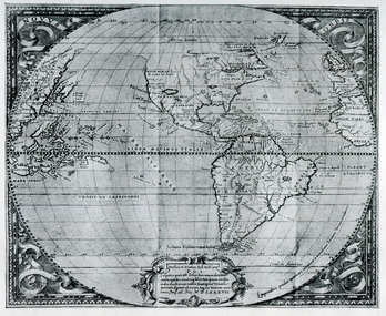
Map, Map Published at Paris, 1587, 1527
... ...early australian mapping...Ballarat Heritage Services PO Box 2209 Bakery Hill Post Office goldfields This map shows a portion of New Guinea, but the plae occupied by Austrlai was left as open ocean. map paris map new guinea early australian mapping Copy of a map from 'A Short HIstory of Australia' by Ernest Scott. ...This map shows a portion of New Guinea, but the plae occupied by Austrlai was left as open ocean.Copy of a map from 'A Short HIstory of Australia' by Ernest Scott.map, paris map, new guinea, early australian mapping -
 Bendigo Military Museum
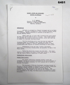
Administrative record - Geodetic Survey and Topographical Mapping in Australia - Report by BP Lambert 1968, 1968
... This paper reports on the progress from early colonial days through to the present time and finally hazards a prediction of future trends. Royal Australian Survey Corps RASvy Fortuna Army Survey Regiment Army Svy Regt ASR National Mapping Photocopy of 18-page typed report including diagrams, stapled top left-hand corner. ...Australia is governed by a Federal Government and by six State Governments. National coordination of their respective geodetic survey and topographic mapping activities is effected on the advice of a National Mapping Council. Twenty years ago, at least 95% of Australia was poorly mapped and what maps existed were in need of revision. only a small area of the continent was covered by horizontal geodetic control and there was no scheme for a national levelling survey. Over the intervening period there has been an urgent and increasing demand for topographic maps varying from large scale contoured maps in support of specific engineering projects to rapid reconnaissance maps required for mineral prospecting in remote areas. Superimposed on this has been a defence requirement, specifically for military training areas, and generally for maps of the whole country. During the period much progress has been made. This paper reports on the progress from early colonial days through to the present time and finally hazards a prediction of future trends.Photocopy of 18-page typed report including diagrams, stapled top left-hand corner. Geodetic Survey and Topographic Mapping a Report by BP Lambert Director of National Mapping, Department of National Development, Canberra, Australia, 1968.royal australian survey corps, rasvy, fortuna, army survey regiment, army svy regt, asr, national mapping -
 Bendigo Military Museum
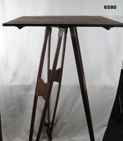
Instrument - Survey Plane Table with Tripod, Circa 1910
... mapping to provide a level surface on which to make drawings, charts or maps. An alidade, with or without a telescope located on the tabletop is used to sight features and draw angles to that feature. Using these lines to the same feature from different setup locations it is possible to locate that feature on the map. Plane Tabeling was widely used by the early members of the Australian...mapping to provide a level surface on which to make drawings, charts or maps. An alidade, with or without a telescope located on the tabletop is used to sight features and draw angles to that feature. Using these lines to the same feature from different setup locations it is possible to locate that feature on the map. Plane Tabeling was widely used by the early members of the Australian ...A Plane Table consists of a smooth wooden table surface (with metal strengthening supports) mounted on a sturdy base. The base, a three-legged Tripod, is designed to support the table over a specific point on land. The connection between the tabletop and the adjustable Tripod legs permits the user to level the table precisely, using bubble levels in a horizontal plane regardless of the roughness of the terrain. The Plane Table is a surveying device used in surveying and mapping to provide a level surface on which to make drawings, charts or maps. An alidade, with or without a telescope located on the tabletop is used to sight features and draw angles to that feature. Using these lines to the same feature from different setup locations it is possible to locate that feature on the map. Plane Tabeling was widely used by the early members of the Australian Survey Corps and in both World Wars. It remains a simple and effective tool to teach the fundamentals of mapping and surveying. It was simple to use and was reasonably robust and portable. See also item 6489.2 for the Plane Table Alidade.A wooden Plane Table with alloy fittings to strengthen and support the table top. The table is fixed to a three-legged wooden Tripod with cast alloy fittings and metal pointed tips.royal australian survey corps, rasvy, fortuna, army survey regiment, army svy regt, asr, 4 fd svy sqn, school of military survey -
 Bendigo Military Museum
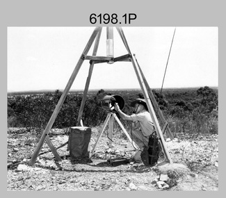
Photograph - Royal Australian Survey Corps Electronic Distance Measuring Equipment Demonstration, c1960s
... mapping and geodetic control operations. The photos were most likely taken in the late 1950s or early 1960s. The tellurometers of this era were man-portable systems that improved geodetic survey efficiencies for rapid network extension and densification replacing triangulation with EDM and theodolite traverse sometimes using Bilby Towers to extend line lengths. Jim Stedman later reached the rank of Colonel, was Director of Military Survey from 1975 to 1978 and was appointed as Colonel Commandant (honorary appointment, Retd) of the Royal Australian...mapping and geodetic control operations. The photos were most likely taken in the late 1950s or early 1960s. The tellurometers of this era were man-portable systems that improved geodetic survey efficiencies for rapid network extension and densification replacing triangulation with EDM and theodolite traverse sometimes using Bilby Towers to extend line lengths. Jim Stedman later reached the rank of Colonel, was Director of Military Survey from 1975 to 1978 and was appointed as Colonel Commandant (honorary appointment, Retd) of the Royal Australian ...This is a set of five photographs of CAPT James ‘Jim’ Leslie Stedman in the field demonstrating the setup of prisms used as electric distance measurement (EDM) receiver reflectors for tellurometer equipment and the sighting of a large surveyor’s light. This equipment was deployed in establishing mapping and geodetic control operations. The photos were most likely taken in the late 1950s or early 1960s. The tellurometers of this era were man-portable systems that improved geodetic survey efficiencies for rapid network extension and densification replacing triangulation with EDM and theodolite traverse sometimes using Bilby Towers to extend line lengths. Jim Stedman later reached the rank of Colonel, was Director of Military Survey from 1975 to 1978 and was appointed as Colonel Commandant (honorary appointment, Retd) of the Royal Australian Survey Corps from 1978 to 1983. Jim Stedman is demonstrating EDM equipment. See item 6180.16P, photos .14) to .16) for more information and photos of Jim Stedman’s EDM demonstration. This is a set of five photographs of a surveyor in the field demonstrating electric distance measurement (EDM) equipment. c1950s – 1960s. The photographs were printed on photographic paper and are part of the Army Survey Regiment’s Collection. The photographs were scanned at 300 dpi. .1) to .2) - Photo, black & white, c1960s, CAPT Jim Stedman demonstrating the sighting of a large surveyor’s light. .3) to .5) – Photo, black & white, c1960s, CAPT Jim Stedman demonstrating EDM prism equipment. .1P to .5P on back – CAPT Stedman EDM Eqpt.royal australian survey corps, rasvy, army survey regiment, army svy regt, fortuna, asr, surveying -
 Federation University Historical Collection
Map - Plan, Ballarat Deep Leads and Mines, 1992, 1992
... Geology Compilation: simplified from earlier Departmental mapping with minor field checking by E.N.M. Plier-Malone. Gold Mines of Australia Gold mines of Victoria Gold mines- Ballarat and District Gold Mines Pitfield Plains District Gold Mines Scarsdale District Gold Mines Berringa Gold Field Gold Mines Rokewood District Gold Mines Sago Hill District Map - Gold Mines Map - Gold Mines in Victoria Ballarat Pitfield Scarsdale Berringa Rokewood Sago Hill Deep Lead Gold Deposits in Victoria Geological Survey - Gold Deposits in Victoria mining gold deposits in Victoria Gold Mines in Victoria Rokewook Pitfield Plains Very large rectangular sheet of paper with seven coloured maps of various sizes and a small green rectangle on the bottom rhs with a map of Victoria superimposed over a poppet head. this rectangle includes information of the other maps shown. ...This is Bulletin No. 62: Deep Lead Gold Deposits in Victoria. Map No.6 Ballarat Sheet 1 of 2 The map shows geology, topography and information on mines in the following areas: one large map of the Ballarat area with five enlargements for: Sago Hill District; Scarsdale District; Pitfield Plains District; Berringa Gold Field and Rokewood District. Ballarat Mines and Deep Leads Report No.94 (Finlay and Douglas,1992) provides a summary of the Geological Survey of Victoria mines database, references and geology for most of the mines on this map. Geology Compilation: simplified from earlier Departmental mapping with minor field checking by E.N.M. Plier-Malone. Very large rectangular sheet of paper with seven coloured maps of various sizes and a small green rectangle on the bottom rhs with a map of Victoria superimposed over a poppet head. this rectangle includes information of the other maps shown. The background for these maps is white. Also includes tables of names of mine companies, name of shafts and gold production.gold mines of australia, gold mines of victoria, gold mines- ballarat and district, gold mines pitfield plains district, gold mines scarsdale district, gold mines berringa gold field, gold mines rokewood district, gold mines sago hill district, map - gold mines, map - gold mines in victoria, ballarat, pitfield, scarsdale, berringa, rokewood, sago hill, deep lead gold deposits in victoria, geological survey - gold deposits in victoria, mining, gold deposits in victoria, gold mines in victoria, rokewook, pitfield plains -
 The Beechworth Burke Museum
Geological specimen - Black Coal
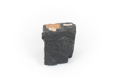
... early example of a coal sample, shows the important role that coal played/plays in Australia's energy generation and manufacturing processes. This specimen is part of a larger collection of geological and mineral specimens collected from around Australia (and some parts of the world) and donated to the Burke Museum between 1868-1880. A large percentage of these specimens were collected in Victoria as part of the Geological Survey of Victoria that begun in 1852 (in response to the Gold Rush) to study and map the geology of Victoria. Collecting geological specimens was an important part of mapping ...This specimen was recovered from Wonthaggi in Victoria. Coal is a sedimentary rock which is composed of peat after it has been exposed over millions of years. This is an example of Australian black coal which is used as either thermal or coking coal for electricity generation or manufacturing processes. It is predominantly composed of Carbon which is 'C' on the periodic table of elements. This early example of a coal sample, shows the important role that coal played/plays in Australia's energy generation and manufacturing processes. This specimen is part of a larger collection of geological and mineral specimens collected from around Australia (and some parts of the world) and donated to the Burke Museum between 1868-1880. A large percentage of these specimens were collected in Victoria as part of the Geological Survey of Victoria that begun in 1852 (in response to the Gold Rush) to study and map the geology of Victoria. Collecting geological specimens was an important part of mapping and understanding the scientific makeup of the earth. Many of these specimens were sent to research and collecting organisations across Australia, including the Burke Museum, to educate and encourage further study.Small piece of black coal with museum original labelGeological survey / R..... S...../ Locality Cape Patterson coal specimen, burke museum, geological survey of victoria, geological specimen, geology -
 The Beechworth Burke Museum
Geological specimen - Spotted Slate, Unknown
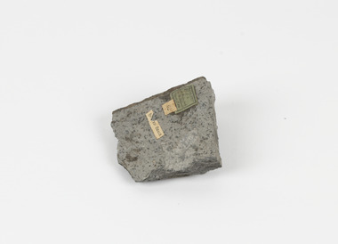
... mapping and understanding the scientific makeup of the earth. Many of these specimens were sent to research and collecting organisations across Australia, including the Burke Museum, to educate and encourage further study. slate spotted slate victoria beechworth burke museum geological specimen mineralogy sedgwick sedgwick victoria spotted slate specimen Spotted Slate / Locality: Sedgwick Victoria | This is an early specimen / from the Quarter sheet / map. ...This specimen was recovered from Sedgwick, VIC. Spotted slate is a fine-grained porphyroblastic metamorphic rock with a number of compounds including muscovite, quartz, graphite with cordierite poikiloblasts and more. The cordierite poikiloblasts are rounded crystals that size up to 2.5 mm. the growth of these crystals is in response to metamorphism of low to medium intensity. The town Sedgwick was named after British geologist Adam Sedgwick This specimen is part of a larger collection of geological and mineral specimens collected from around Australia (and some parts of the world) and donated to the Burke Museum between 1868-1880. A large percentage of these specimens were collected in Victoria as part of the Geological Survey of Victoria that begun in 1852 (in response to the Gold Rush) to study and map the geology of Victoria. Collecting geological specimens was an important part of mapping and understanding the scientific makeup of the earth. Many of these specimens were sent to research and collecting organisations across Australia, including the Burke Museum, to educate and encourage further study.A solid rectangular hand-sized spotted slate specimen in a shade of light grey with darker flecks throughout Spotted Slate / Locality: Sedgwick Victoria | This is an early specimen / from the Quarter sheet / map. See sample 62 / page 18. Described as 'Spotted Slate' but these / days we would call it spotted hornfels / C. William 15/4/21 slate, spotted slate, victoria, beechworth, burke museum, geological specimen, mineralogy, sedgwick, sedgwick victoria, spotted slate specimen -
 The Beechworth Burke Museum
Geological specimen - Opal Bearing Stone, Unknown
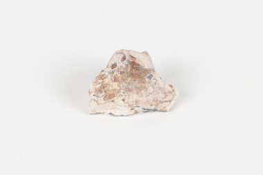
... early 1900s causing interest in the area. This specimen is part of a larger collection of geological and mineral specimens collected from around Australia (and some parts of the world) and donated to the Burke Museum between 1868-1880. A large percentage of these specimens were collected in Victoria as part of the Geological Survey of Victoria that begun in 1852 (in response to the Gold Rush) to study and map the geology of Victoria. Collecting geological specimens was an important part of mapping ...There are 17 opal fields in Australia. This opal bearing stone was found in Lightning Ridge, NSW over what is known as the Great Australian Basin. This basin was formed and covers an area of 1.7 million square kilometers in eastern Australia in the Cretaceous period. This basin used to contain an inland sea, which provided an environment where silcrete eventually formed when water levels changed. This eventually seeped into other structures, and eventually hardened and formed opal. Lightning Ridge has a population of around 2000 people, with about 80 000 visitors every year. It is a historic mining town, and is known for its deposits of a rare black opal. Mining started in the area in the late 1800s, early 1900s when the black opal was discovered. This opal-bearing stone is of social and historical significance. It is from Lightning Ridge, which is well-known for being a large producer of opal stones, most famously black opal. The history of the period dates back to 140 million years, with the discovery of black opal in the early 1900s causing interest in the area. This specimen is part of a larger collection of geological and mineral specimens collected from around Australia (and some parts of the world) and donated to the Burke Museum between 1868-1880. A large percentage of these specimens were collected in Victoria as part of the Geological Survey of Victoria that begun in 1852 (in response to the Gold Rush) to study and map the geology of Victoria. Collecting geological specimens was an important part of mapping and understanding the scientific makeup of the earth. Many of these specimens were sent to research and collecting organisations across Australia, including the Burke Museum, to educate and encourage further study.***A palm-sized solid mineral specimen in shades of beige and light orange*** silica based? burke museum, beechworth, geological, geological specimen, opal, opal fields, australia, lightning ridge, new south wales, great australian basin, cretaceous, silcrete, black opal, mining -
 The Beechworth Burke Museum
Geological specimen - Garnet crystals in galena, Unknown
... Australia during the early to late 19th Century. The fact that it is only found in one mining area of Australia, shows that this specimen is rare for examples of Australian Galena. This mineral specimen is one part to a larger collection, aquistion, and distribution of Garnet in Galena around Australia and parts of the world and donated to the Burke Museum between 1860-1880. While this specimen was not found by the Victorian Geological Survey, it shows the historical need for mapping ...Majority of Galena in Australia is found in hydrothermal deposits emplaced around 1680 million years ago which have been heavily metamorphosed. Galena is the natural mineral form of lead sulfaide. It occurs generally as fine to large crystals due to syntectonic remobilization at low temperatures and moves to a suitable location. The colour is a shining lead and silvery gray with high specific gravity between 7.2 and 7.6 gms/cm3 and contains 86.6 lead sulfaide in its purest form. Its cyrstal system is cubic with perfect cleavages, and contract penetration and lamellar twinning. This particular specimen is from the Broken Hill mine, it is one of the largest lead mines located in Western New South Wales and still has ore reserves amounting to 20.9 million tonnes of ore grading of 7.4% lead, 9.4% zinc, and 61.5 million oz of Silver. Throughout its history, it has produced over 200 million tonnes of ore throughout its 127 years of mining history dating back to 1885. Galena mineral ore found in Australia is considered rare, as it is only currently found in the Broken Hill Mine of Western New South Wales. It represents heritage value through the systematic collecting of the geological surveyers in Victoria and Australia during the early to late 19th Century. The fact that it is only found in one mining area of Australia, shows that this specimen is rare for examples of Australian Galena. This mineral specimen is one part to a larger collection, aquistion, and distribution of Garnet in Galena around Australia and parts of the world and donated to the Burke Museum between 1860-1880. While this specimen was not found by the Victorian Geological Survey, it shows the historical need for mapping geological areas around the Gold Rush region to further identify areas of precious metal and gem aquisition. Additionally, collecting these specimens was an important part of mapping the scientific make up of the earth's surface. Many were sent to institutions for further contribution to research and scientific knowledge of the specimens. A solid coin-sized lead and zinc sulphaide and zinc silicate ore mineral in shades of black and red with shiny black points. GARNET CRYSTALS in / GALENA (lead sulphide), / SPALERITE (zinc sulphide), / WILLEMITE (zinc silicate) ore. / Locality: Broken Hill, NSWburke museum, #beechworth, indigo shire, beechworth museum, geological, geological specimen, mineral, galena, galena quartz, broken hill mine, broken hill, nsw -
 The Beechworth Burke Museum
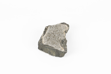
Geological specimen - Pyrite crystals in black slate, Unknown
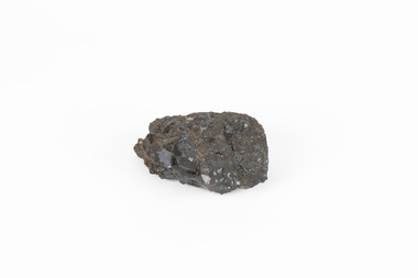
... Collecting these specimens was an important part of Australia's early Geoplogical scientific discovery for mapping the earth's surface. ...Pyrite also known as iron Pyrite or fools gold is an iron sulfide with a chemical formula of FeS2 and is the most abundant sulfide mineral. Its metallic luster and pale brass-yellow hue give it a superficial resemblance to gold for which its nickname of Fools Gold comes from. There are a number of iron pyrite mines in Victoria and many would have been mined during Victoria's Gold Rush revolution in the 19th century. As it's lustrius yellow metallic look closely resembles gold, it is likely that it was often mistaken for gold as real gold was also often found in similar metamorphic and sedimentary rock. This specimen is part of a larger collection of geological and mineral specimens collected from around Australia (and some parts of the world) and donated to the Burke Museum between 1868-1880. A large percentage of these collections were collected in Victoria as part of the Geological Survey of Victoria that begun in 1852 (in response to the Gold Rush). Collecting these specimens was an important part of Australia's early Geoplogical scientific discovery for mapping the earth's surface. It is unknown where in Victoria this specimen was mined from however; it shows strong provenance connections to Victoria's gold mining history and represents through larger economic and cultural structures the impact the Gold Rush had on Victoria during the 19th century. A solid coin-sized Pyrite crystal in black slate in shades of beige with tiny crystal structures. Pyrite / crystals / BB / in black slate / probably / victoria / (nice specimen)geology, geological specimen -
 Greensborough Historical Society
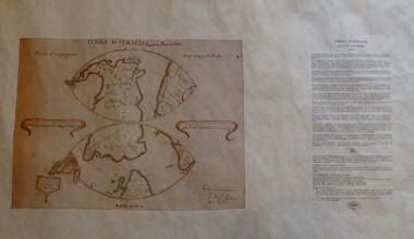
Map, Mapping Authority of NSW, Terra Australis: Quinta Pars Orbis, 1676_
... Australia. Reproduction of an early map of Australia, pre-dating the voyages of Captain Cook. terra australis Facsimile map in cardboard protective tube Terra Australis: Quinta Pars Orbis Map Mapping Authority of NSW ...The original of this map was drawn by an Italian priest Father Victorio Riccio in 1676 from knowledge brought to Manila on Dutch ships. Father Riccio was suggesting a Catholic mission to Terra Australia.Reproduction of an early map of Australia, pre-dating the voyages of Captain Cook.Facsimile map in cardboard protective tubeterra australis -
 Merri-bek City Council
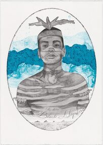
Lithograph, Megan Cope, Black Napoleon (Eulope), 2019
... mapping practices. Black Napoleon (Eulope) is part of a series of lithographs that highlights what Cope sees as ‘just one of the many stories of powerful and clever people defying Empire’ at the turn of the 19th century in Australia. The Black Napoleon series was produced as part of the Australian Print Workshop’s French Connections project. The project aimed to produce new work responding to the National Archive in Paris, with a focus on cultural materials relating to early...mapping practices. Black Napoleon (Eulope) is part of a series of lithographs that highlights what Cope sees as ‘just one of the many stories of powerful and clever people defying Empire’ at the turn of the 19th century in Australia. The Black Napoleon series was produced as part of the Australian Print Workshop’s French Connections project. The project aimed to produce new work responding to the National Archive in Paris, with a focus on cultural materials relating to early ...Working across installation, video and painting, Quandamooka artist Megan Cope investigates issues relating to colonial histories, the environment and mapping practices. Black Napoleon (Eulope) is part of a series of lithographs that highlights what Cope sees as ‘just one of the many stories of powerful and clever people defying Empire’ at the turn of the 19th century in Australia. The Black Napoleon series was produced as part of the Australian Print Workshop’s French Connections project. The project aimed to produce new work responding to the National Archive in Paris, with a focus on cultural materials relating to early exploration of Australia and the Pacific. It was important to Cope that she did not simply repeat the material of the archive, which was collected and conserved within a colonial framework. Instead, Cope’s work addresses Eulope’s sovereignty and role in resisting invasion. Eulope was a Quandamooka man named after Napoleon Buonaparte because of his leadership in battles against British forces, which invaded Stradbroke Island in the early 1800s. -
Victorian Aboriginal Corporation for Languages
Map, Geographic Data Victoria, Vicmap topographic map index as at June 2000, 2000
... Index to Vicmap topographic mapping, including 1:25 000 and 1:50 000 topographic maps, and Outdoor leisure series, compiled by the earlier bodies, Survey &? Mapping Victoria, etc. Also indexes Royal Australian...Victorian Aboriginal Corporation for Languages 33 Saxon Street Brunswick melbourne Victorian maps topographic maps maps Index to Vicmap topographic mapping, including 1:25 000 and 1:50 000 topographic maps, and Outdoor leisure series, compiled by the earlier bodies, Survey &? Mapping Victoria, etc. Also indexes Royal Australian ...Index to Vicmap topographic mapping, including 1:25 000 and 1:50 000 topographic maps, and Outdoor leisure series, compiled by the earlier bodies, Survey &? Mapping Victoria, etc. Also indexes Royal Australian Survey Corps' 1:50 000 topographic mapping.mapsvictorian maps, topographic maps -
 The Beechworth Burke Museum
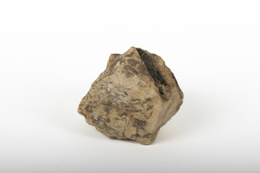
Geological specimen - Biotite in Graphic Granite
... Collecting these specimens was an important part of Australia's early Geological scientific discovery for mapping the earth's surface. ...Graphic Granite is an igneous rock formed through magma or lava and is characterised by its unique inter-growth of quartz, crystals and biotite (black mica minerals). Like other granites, graphic granite crystallizes deep within the earth's crust under pressure. When split, graphic granite can reveal interesting structures that may resemble symbols, hieroglyphs or crude attempts at writing.This specimen is part of a larger collection of geological and mineral specimens collected from around Australia (and some parts of the world) and donated to the Burke Museum between 1868-1880. A large percentage of these collections were collected in Victoria as part of the Geological Survey in Victoria that began in 1852 in response to the Gold Rush. Collecting these specimens was an important part of Australia's early Geological scientific discovery for mapping the earth's surface. A small textured caramel-coloured rock with brown marbling and indentations revealing pieces of Biotite (Black Mica). A marking with a star-like appearance is visible in the Biotite on the front of the rock. graphic granite, granite, biotite, black mica, burke museum, beechworth, geological specimen, mineralogy, minerals, geology collection -
 Bendigo Historical Society Inc.
Newspaper - Fortuna Article - "Villa fit for a Quartz King", Mar 08 1997
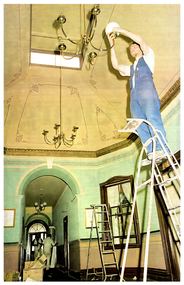
... The project, named Parare, is valued between $8 million and $10 million.Its goal is to position ATSE as a leading defence mapping organization in Australia and internationally.The initiative addresses outdated hardware, enabling the production and distribution of digital defence data across Australia.Project TimelineTenders for the project are set to close soon, indicating the project is in its early procurement phase. ...The project, named Parare, is valued between $8 million and $10 million.Its goal is to position ATSE as a leading defence mapping organization in Australia and internationally.The initiative addresses outdated hardware, enabling the production and distribution of digital defence data across Australia.Project TimelineTenders for the project are set to close soon, indicating the project is in its early procurement phase. ...The article outlines the launch of the Fortuna program's new computer mapping project at the Army Topographic Support Establishment (ATSE). Workforce ExpansionATSE will increase its staff from 135 to 150, adding 15 new jobs as a result of the project. The project, named Parare, is valued between $8 million and $10 million.Its goal is to position ATSE as a leading defence mapping organization in Australia and internationally.The initiative addresses outdated hardware, enabling the production and distribution of digital defence data across Australia.Project TimelineTenders for the project are set to close soon, indicating the project is in its early procurement phase. The historic Fortuna property is undergoing a $1.5 million refurbishment to restore the main building and outbuildings to their original 1870s grandeur. Over 40 workers spent at least two months on the project, which includes new carpets, painting, lighting, rewiring, and rehabilitation of a former stone crushing area. Fortuna Villa was built by George Lansell, a prominent figure in Bendigo's gold mining history, and designed by architects W. C. Vahland and William Beebe. The property has served as home to the Army Survey Regiment for 54 years and was recently taken over by the Army Topographic Support Establishment (ATSE). The fully restored three-level building will open to the public on March 16, with guided tours every Sunday for $8 per person, including devonshire teas in the hall. ATSE will move its production and administrative staff into the villa after renovations, with printing operations at the rehabilitated stone crushing site. State-of-the-art computer equipment will be installed in the building. 20 beer bottles from the 1940s were found in a ceiling.Fortuna Restoration Article - "Villa fit for a Quartz King" - Bendigo Advertiser Sat Mar 08 1997 - Author Ashok Verma This item contains the following: 11217.1a Couloured photo of Brad Murray fixing a light shade as part of the retoration work 11217.1b Part of page 2 - Fortuna Program Maps out new jobs 11217.1c Part of page 2 - Fortuna Program Maps out new jobsnon-fictionbendigo, fortuna, army tropographic support establishment -
 Bendigo Military Museum
Administrative record - Soldiers and Surveyors by SE Rilley - Roles of Crown's Armed Forces UK and Australia, The Institution of Surveyors, Australia, Mar 1983
... Australian Mapping Agencies. This document records in detail with Names, the contribution of Officers of the Crown in the early stages of the settlement of Australia. ...Australian Mapping Agencies. This document records in detail with Names, the contribution of Officers of the Crown in the early stages of the settlement of Australia. ...This is a photocopy of an original article written by SE Reilly titled "Soldier Surveyors" that was then republished in the Australian Surveyor March 1983 Vol 31 No. 5 pages 315 - 326. The Author was Capt SE Riley MBE Hon FIS Aust, FRICS, President of the Institution of Surveyors, Australia 1957-1959. Includes Histories of both UK and Australian Mapping Agencies. This document records in detail with Names, the contribution of Officers of the Crown in the early stages of the settlement of Australia. Starting in 1787 their contributions were significant with most occupying positions as State Surveyors General and eventually contributing to the formation of the Australian Intelligence Corps in 1907, a survey section within the Australian Engineers 1910 and eventually the Australian Survey Corps in 1915. This is a very detailed description of the personnel involved and the formation of the Australian Survey Corps, later the title "Royal" was granted in 1948 to become the Royal Australian Survey Corps.Eleven A4 photocopied pages of typed text extracted from the Australian Surveyor March 1983 Vol 31 No. 5 pages 315 - 326royal australian survey corps, rasvy, fortuna, army survey regiment, army svy regt, asr