Showing 336 items matching "eastern area"
-
 National Wool Museum
Book, Wool in the eastern Europe area, 1980
... Wool in the eastern Europe area, 1980..."Wool in the eastern Europe area, 1980." Simon Newland, International Wool Secretariat....National Wool Museum 26 Moorabool Street Geelong geelong-and-the-bellarine-peninsula "Wool in the eastern Europe area, 1980." Simon Newland, International Wool Secretariat. ..."Wool in the eastern Europe area, 1980." Simon Newland, International Wool Secretariat.wool growing sheep - european yarn production textile production trade - international, international wool secretariat, carpet, cloth - woollen, wool growing, sheep - european, yarn production, textile production, trade - international -
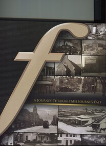 Surrey Hills Historical Society Collection
Book, A journey through Melbourne's east, 2008
... A collection of photographs of the local eastern area of Melbourne showing a lot of 'then' and 'now' photographs....A collection of photographs of the local eastern area of Melbourne showing a lot of 'then' and 'now' photographs....A collection of photographs of the local eastern area of Melbourne showing a lot of 'then' and 'now' photographs. fletcher and parker fletchers real estate agents melbourne hawthorn balwyn camberwell kew land use ashburton montagnana-wallace (mr) neil wallace (mr) neil montagnana A collection of photographs of the local eastern area of Melbourne showing a lot of 'then' and 'now' photographs. ...Pictorial representation of the development of Melbourne's eastern suburbs. A collection of photographs of the local eastern area of Melbourne showing a lot of 'then' and 'now' photographs.A collection of photographs of the local eastern area of Melbourne showing a lot of 'then' and 'now' photographs.fletcher and parker, fletchers, real estate agents, melbourne, hawthorn, balwyn, camberwell, kew, land use, ashburton, montagnana-wallace, (mr) neil wallace, (mr) neil montagnana -
Save the Dandenongs League Inc.
Archive (item), Save the Dandenongs League Incorporated, Draft for Public Comment - SEGA [South Eastern Growth Area] - Hinterland Impacts Study
... Draft for Public Comment - SEGA [South Eastern Growth Area] - Hinterland Impacts Study...Upper Yarra Valley and Dandenong Ranges Authority (UYVDRA) Draft for Public Comment - SEGA [South Eastern Growth Area] - Hinterland Impacts Study Archive Save the Dandenongs League Incorporated ...upper yarra valley and dandenong ranges authority (uyvdra) -
Whitehorse Historical Society Inc.
Article, Aspects of local shops, 2013
... Shopping from village to internet in eastern areas of Melbourne....Talk by Gerry Robinson to a General Meeting of Whitehorse Historical Society on 10 August 2013 on shopping from village to internet in eastern areas of Melbourne....Talk by Gerry Robinson to a General Meeting of Whitehorse Historical Society on 10 August 2013 on shopping from village to internet in eastern areas of Melbourne. Aspects of local shops Article Article ...Talk by Gerry Robinson to a General Meeting of Whitehorse Historical Society on 10 August 2013.Talk by Gerry Robinson to a General Meeting of Whitehorse Historical Society on 10 August 2013 on shopping from village to internet in eastern areas of Melbourne.Talk by Gerry Robinson to a General Meeting of Whitehorse Historical Society on 10 August 2013.shops, heathmont, ringwood, canterbury road, robinson, gerry, whitehorse historical society inc -
Ballarat Tramway Museum
Sign - Sign - Destination Blinds, Trains, Vuictorian Rail Suburban Train Destination Blind in miniature - North and East stations, Melbourne
... ...eastern area...eastern suburbs that the train travels to. Place names listed are Lalor, Epping, South Morang, Heidelberg, Macleod, Greensborough, Eltham, East Doncaster, Princes Bridge, City Circle, City Loop, Flinders Street, Spencer Street, Camberwell, Box Hill, Ringwood, Croydon, Lilydale, Coldstream, Upper Ferntree Gully, Belgrave, Alamein, Darling, Glen Waverley. train destination blind northern area eastern area lalor epping south morang macleod greensborough eltham hurstbridge east doncaster princes bridge city circle city loop flinders street spencer street camberwell box hill ringwood croydon lilydale coldstream upper ferntree gully belgrave alamein darling glen waverley Station names List of station names on black paper written in white Vuictorian Rail Suburban Train Destination Blind in miniature - North and East stations, Melbourne Sign Sign - Destination Blinds, Trains ...Ron Bridger was an avid collector of items related to transport, predominately Trams. These items include newspaper cuttings, pamphlets, reports, timetables, fares prices plus special items relating to events. Items from Melbourne and regional Victoria, interstate - Adelaide and Sydney, plus overseas, make up this collection. A suburban train destination blind in miniature. Place names indicate the northern and eastern suburbs that the train travels to. Place names listed are Lalor, Epping, South Morang, Heidelberg, Macleod, Greensborough, Eltham, East Doncaster, Princes Bridge, City Circle, City Loop, Flinders Street, Spencer Street, Camberwell, Box Hill, Ringwood, Croydon, Lilydale, Coldstream, Upper Ferntree Gully, Belgrave, Alamein, Darling, Glen Waverley. List of station names on black paper written in whiteStation namestrain destination blind, northern area, eastern area, lalor, epping, south morang, macleod, greensborough, eltham, hurstbridge, east doncaster, princes bridge, city circle, city loop, flinders street, spencer street, camberwell, box hill, ringwood, croydon, lilydale, coldstream, upper ferntree gully, belgrave, alamein, darling, glen waverley -
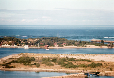 Lakes Entrance Historical Society
Photograph - Bullock Island 1962
... Colour photograph of Bullock Island showing cleared and grass planted south eastern area in preparation for relocation of Public Works and fishing industry facilities. ...Lakes Entrance Historical Society 4 Marine Parade Lakes Entrance gippsland Image printed from 35mm slide Bridges Waterways Topography Colour photograph of Bullock Island showing cleared and grass planted south eastern area in preparation for relocation of Public Works and fishing industry facilities. ...Image printed from 35mm slideColour photograph of Bullock Island showing cleared and grass planted south eastern area in preparation for relocation of Public Works and fishing industry facilities. Traffic access to island via humpy bridge. Lakes Entrance Victoriabridges, waterways, topography -
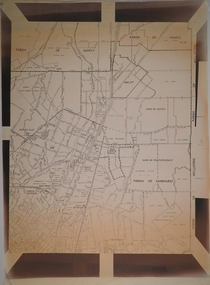 Bendigo Historical Society Inc.
Map - CAMPBELL COLLECTION: BENDIGO AND DISTRICT MAPS
... Map. Eastern area of Bendigo, Parish of Huntly, Ascot, Shire of Huntly, Jackass Flat, Old White Hills, White Hills, Emu Point, North Bendigo, East Bendigo, Strathdale, Parish of Strathfieldsaye, Parish of Sandhurst, Parish of Wellsford....MAP Bendigo parishes Map. Eastern area of Bendigo, Parish of Huntly, Ascot, Shire of Huntly, Jackass Flat, Old White Hills, White Hills, Emu Point, North Bendigo, East Bendigo, Strathdale, Parish of Strathfieldsaye, Parish of Sandhurst, Parish of Wellsford. ...Map. Eastern area of Bendigo, Parish of Huntly, Ascot, Shire of Huntly, Jackass Flat, Old White Hills, White Hills, Emu Point, North Bendigo, East Bendigo, Strathdale, Parish of Strathfieldsaye, Parish of Sandhurst, Parish of Wellsford.map, bendigo, parishes -
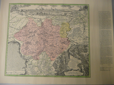 Bendigo Historical Society Inc.
Map - STRAUCH COLLECTION: MAP EPISCOPATUS PADERBORNENSIS
... Paderdorm is a city in the Eastern area of North Rhine-Westphalia at the source of the river Pader....History House 11 Mackenzie Street Bendigo goldfields Paderdorm is a city in the Eastern area of North Rhine-Westphalia at the source of the river Pader. ...Paderdorm is a city in the Eastern area of North Rhine-Westphalia at the source of the river Pader.Coloured map of Paderborn Germany, Presented to the German Heritage Society, Bendigo on 17.1.1995 by the most Reverend J.J.Degenhardt D.D.Archbishop of Paderborn on his visit to Bendigo with the Reverend Monsignor B.Kresing. Vicar-General, Paderborn and Rev. Father M.Reitemeier. (Chaplain)map, maps-germany-paderborn-german heritage society -
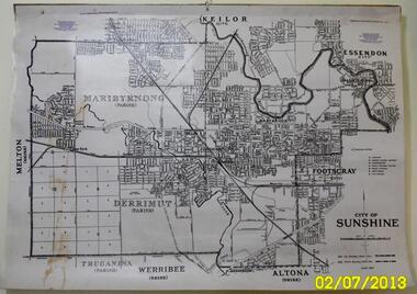 Sunshine and District Historical Society Incorporated
Map - CITY OF SUNSHINE MAP June 1967, 1967
... Part of the eastern area has been annexed by the City of Maribyrnong, and the rest of the old City of Sunshine has been amalgamated with the City of Keilor to form the larger City of Brimbank....The City of Sunshine no longer exists. Part of the eastern area has been annexed by the City of Maribyrnong, and the rest of the old City of Sunshine has been amalgamated with the City of Keilor to form the larger City of Brimbank. ...The City of Sunshine no longer exists. Part of the eastern area has been annexed by the City of Maribyrnong, and the rest of the old City of Sunshine has been amalgamated with the City of Keilor to form the larger City of Brimbank.This 1967 map is a historical record of the City of Sunshine as it existed 27 years before the amalgamation of Councils, and the creation of the City of Brimbank in 1994.Whitish paper map with black printing that is laminated in clear plastic film, and has a wood slat attached to the top edge. The June 1967 map is of the previous CITY OF SUNSHINE showing City and Parish boundaries, streets, railways, creeks, river etc.Purple ink stamps at top left hand and right hand areas showing address and contact details of 'Sunshine Industrial Promotion Centre.'city of sunshine, june 1967, map, city, parish, boundaries, brimbank -
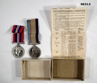 Bendigo Military Museum
Award - MEDALS, BOXED WW2, Post 1945
... Discharged 8/11/45 at rank of Sgt in HQ North Eastern Area. Born 1911. Died 1 Dec 1962, at Quarry Hill, Vic, aged 51. ...Discharged 8/11/45 at rank of Sgt in HQ North Eastern Area. Born 1911. Died 1 Dec 1962, at Quarry Hill, Vic, aged 51. ..."Charles Thomas Biggs" No. 51893 RAAF. Enlisted 16/3/42 aged 31. Discharged 8/11/45 at rank of Sgt in HQ North Eastern Area. Born 1911. Died 1 Dec 1962, at Quarry Hill, Vic, aged 51. Buried at Bendigo Cemetery.1. War Medal 1939-1945. 2. Australian Service Medal 1939 - 45. 3. Instructions on Guidance of how medals are to be worn on civilian clothes. 4. White box bottom. 5. White medal box top.1. Inscribed with George VI and Lion over a fallen Eagle. 2. Inscribed Aust. Service Medal 1939-45 with Commonwealth Emblem and George VI on other side. 3. Stamped 1966 & RAAF medal Section, Vic Barracks, Melbourne.charles thomas biggs, raaf, ww2, australia service medal, war medal 1939-45 -
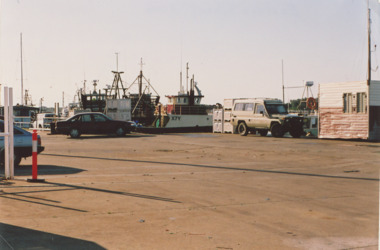 Lakes Entrance Historical Society
Photograph - Eastern Wharf Lakes Entrance c2006, M Holding
... Unloading area Eastern Wharf showing boats moored and vehicles parked on loading bay Lakes Entrance Victoria. ...Colour photograph of unloading area Eastern Wharf showing boats moored and vehicles parked on loading bay Lakes Entrance Victoria. ...Unloading area Eastern Wharf showing boats moored and vehicles parked on loading bay Lakes Entrance Victoria. ...Unloading area Eastern Wharf showing boats moored and vehicles parked on loading bay Lakes Entrance Victoria. Also a colour postcard of fishing boats moored at eastern extension of Eastern Wharf Cunninghame Arm footbridge in background Inscription Some of the Fishing fleet at the Fish Wharf Lakes Entrance Vic 04262.1 10 x 15 cmColour photograph of unloading area Eastern Wharf showing boats moored and vehicles parked on loading bay Lakes Entrance Victoria. Also a colour postcard of fishing boats moored at eastern extension of Eastern Wharf Cunninghame Arm footbridge in background Inscription Some of the Fishing fleet at the Fish Wharf Lakes Entrance Victoria,.boats and boating, boardwalk, township, waterways -
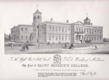
 St Patrick's Old Collegians Association (SPOCA)
Photograph - Buildings, Eastern Hill, Colleges 1
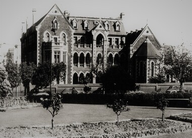
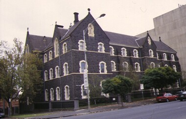
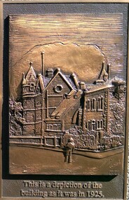
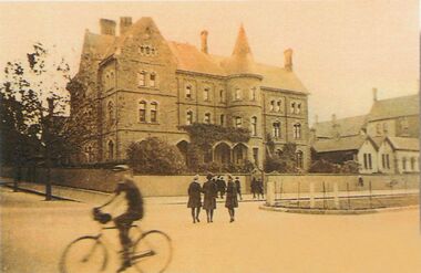
... (One of eight schools starting in the Eastern Hill area during 1849 -1902 : MGS, Scotch, SPJC, MHC, Academy, Parade, PLC and CLC.)...(One of eight schools starting in the Eastern Hill area during 1849 -1902 : MGS, Scotch, SPJC, MHC, Academy, Parade, PLC and CLC.) ... -
 St Patrick's Old Collegians Association (SPOCA)
Photograph - Buildings, Eastern Hill, Colleges, 2
... (One of eight schools starting in the Eastern Hill area during 1849 -1902 : MGS, Scotch, SPJC, MHC, Academy, Parade, PLC and CLC.) ...(One of eight schools starting in the Eastern Hill area during 1849 -1902 : MGS, Scotch, SPJC, MHC, Academy, Parade, PLC and CLC.) ... -
 St Patrick's Old Collegians Association (SPOCA)
Photograph - Buildings, Eastern Hill, Colleges, 3
... (One of eight schools starting in the Eastern Hill area during 1849 -1902 : MGS, Scotch, SPJC, MHC, Academy, Parade, PLC and CLC.) ...(One of eight schools starting in the Eastern Hill area during 1849 -1902 : MGS, Scotch, SPJC, MHC, Academy, Parade, PLC and CLC.) ... -
 St Patrick's Old Collegians Association (SPOCA)
Photograph - Buildings, Eastern Hill, Colleges, 5.1
... (One of eight schools starting in the Eastern Hill area during 1849 -1902 : MGS, Scotch, SPJC, MHC, Academy, Parade, PLC and CLC.)...(One of eight schools starting in the Eastern Hill area during 1849 -1902 : MGS, Scotch, SPJC, MHC, Academy, Parade, PLC and CLC.) ... -
 St Patrick's Old Collegians Association (SPOCA)
Photograph - Buildings, Eastern Hill, Colleges, 6
... (One of eight schools starting in the Eastern Hill area during 1849 -1902 : MGS, Scotch, SPJC, MHC, Academy, Parade, PLC and CLC.)...(One of eight schools starting in the Eastern Hill area during 1849 -1902 : MGS, Scotch, SPJC, MHC, Academy, Parade, PLC and CLC.) ... -
 St Patrick's Old Collegians Association (SPOCA)
Photograph - Buildings, SPJC, Artworks, Griffin (0)
... St Patrick's College was one of eight schools starting in the Eastern Hill area during 1849 -1902 : MGS, Scotch, SPJC, MHC, Academy, Parade, PLC and CLC. ...St Patrick's College was one of eight schools starting in the Eastern Hill area during 1849 -1902 : MGS, Scotch, SPJC, MHC, Academy, Parade, PLC and CLC. ... -
 Lakes Entrance Historical Society
Album - Oil Drilling Lakes Entrance, Charlie Carpenter, 1936 c
... Photograph album containing views of oil drilling operations in Lakes Entrance area particularly Eastern Bore Lakes Entrance Victoria...Lakes Entrance Historical Society 4 Marine Parade Lakes Entrance gippsland Oil drilling Local History Oil and Gas Industry Photograph album containing views of oil drilling operations in Lakes Entrance area particularly Eastern Bore Lakes Entrance Victoria Album Oil Drilling Lakes Entrance Charlie Carpenter ...Photograph album containing views of oil drilling operations in Lakes Entrance area particularly Eastern Bore Lakes Entrance Victoriaoil drilling, local history, oil and gas industry -
 Kiewa Valley Historical Society
Papers - The Tobacco Industry
... areas were suited. A Tobacco Research Station was established in Myrtleford, the geographical centre of the North Eastern tobacco growing area....areas were suited. A Tobacco Research Station was established in Myrtleford, the geographical centre of the North Eastern tobacco growing area. ...Tobacco in the Kiewa Valley. Tobacco was grown in Victoria for many years but the main areas (from the 1960s) included the Upper Kiewa River Valley where areas were suited. A Tobacco Research Station was established in Myrtleford, the geographical centre of the North Eastern tobacco growing area.Tobacco was grown successfully in the Kiewa Valley1. Leaflets x2 Green paper - 'The Tobacco Plant' Prepared by The Tobacco Growers of Victoira Limited in consultation with the Dept. of Agriculture Tobacco Research Station, Ovens. 1980s 2. papers yellowed and printed on both sides. - 'The Golden Leaf - The story of the tobacco leaf. Prepared by the Tobacco Growers of Victoria Ltd.' 1980stobacco, kiewa valley, agricultural farming -
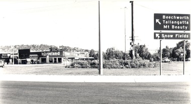
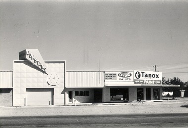
 Wodonga & District Historical Society Inc
Photograph - Codling Collection 01 - Dunstan’s Corner - Thomas Mitchell Drive, c1987
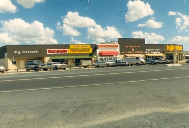
... A large proportion of the company's timber output was processed at the Wodonga yards into flooring, weatherboards, mouldings etc. and practically the whole output was distributed locally and throughout the Riverina and eastern areas of New South Wales, and Canberra. ...A large proportion of the company's timber output was processed at the Wodonga yards into flooring, weatherboards, mouldings etc. and practically the whole output was distributed locally and throughout the Riverina and eastern areas of New South Wales, and Canberra. ...These Wodonga photos are part of a collection donated by Miss Olive Codling. Arthur Dunstan Arthur Dunstan established mills at Red Bluff on the Mitta and a timber yard at Wodonga. He also built a sawmill at Glen Wills in 1931 which operated for about 16 years. A larger and more modern sawmill with drying kilns was erected at Eskdale in 1947. He was contracted to build Wodonga’s Municipal sale yards in 1935, followed by the Wangaratta sale yards. This created so many forward orders that he bought a large block of land on the corner of Beechworth and Tallangatta Roads and opened a timber mill and hardware store. The business stood on this corner for about 40 years. A large proportion of the company's timber output was processed at the Wodonga yards into flooring, weatherboards, mouldings etc. and practically the whole output was distributed locally and throughout the Riverina and eastern areas of New South Wales, and Canberra. At its peak Dunstan’s was one of the biggest sawmilling businesses in Victoria and in Wodonga employed 150 people and milled l6,000,000 super feet of timber annually. A super foot is a measurement for timber, equal to one foot square by one inch thick. Arthur Dunstan also built Tower Place in High Street. He died in Wodonga in 1963 and the business was continued on by his sons. Dunstan’s timber yards in Wodonga were sold to Ezerd Industries in 1987 with the retail section being bought by BBC Hardware.This photo collection is significant as it documents how the businesses and buildings in Wodonga have evolved and contributed to community throughout the 20th century.The first business at this location was a timber will and hardware store established by Arthur Dunstan in 1935. It operated there for about 40 years. Businesses from left to right: Dry Cleaner, Delicatessen, Twin Cities Fruit & Vege Market, Ollies Family Restaurant, Victoria Star Hot Bread Kitchen, Trophies and Gifts, and Horseland. This area is not referred to as Southside and the former Horseland premises are not occupied by an Italian restaurant.wodonga businesses, dunstan's corner wodonga, thomas mitchell drive -
 Wodonga & District Historical Society Inc
Photograph - Codling Collection 01 - Dunstan’s Corner and Beechworth Road Roundabout, Mid 1980s
... A large proportion of the company's timber output was processed at the Wodonga yards into flooring, weatherboards, mouldings etc. and practically the whole output was distributed locally and throughout the Riverina and eastern areas of New South Wales, and Canberra. ...A large proportion of the company's timber output was processed at the Wodonga yards into flooring, weatherboards, mouldings etc. and practically the whole output was distributed locally and throughout the Riverina and eastern areas of New South Wales, and Canberra. ...These Wodonga photos are part of a collection donated by Miss Olive Codling. Arthur Dunstan Arthur Dunstan established mills at Red Bluff on the Mitta and a timber yard at Wodonga. He also built a sawmill at Glen Wills in 1931 which operated for about 16 years. A larger and more modern sawmill with drying kilns was erected at Eskdale in 1947. He was contracted to build Wodonga’s Municipal sale yards in 1935, followed by the Wangaratta sale yards. This created so many forward orders that he bought a large block of land on the corner of Beechworth and Tallangatta Roads and opened a timber mill and hardware store. The business stood on this corner for about 40 years. A large proportion of the company's timber output was processed at the Wodonga yards into flooring, weatherboards, mouldings etc. and practically the whole output was distributed locally and throughout the Riverina and eastern areas of New South Wales, and Canberra. At its peak Dunstan’s was one of the biggest sawmilling businesses in Victoria and in Wodonga employed 150 people and milled l6,000,000 super feet of timber annually. A super foot is a measurement for timber, equal to one foot square by one inch thick. Arthur Dunstan also built Tower Place in High Street. He died in Wodonga in 1963 and the business was continued on by his sons. Dunstan’s timber yards in Wodonga were sold to Ezerd Industries in 1987 with the retail section being bought by BBC Hardware.This photo collection is significant as it documents how the businesses and buildings in Wodonga have evolved and contributed to community throughout the 20th century.The first business at this location was a timber will and hardware store established by Arthur Dunstan in 1935. It operated there for about 40 years. In this photo Horseland occupies the corner premises including a video outlet. On the left is the Victoria Star Hot Bread Kitchen. This area is now know as Southside.wodonga businesses, dunstan's corner wodonga, thomas mitchell drive -
 Bendigo Historical Society Inc.
Document - MCCOLL, RANKIN AND STANISTREET COLLECTION: THE SEDGWICK GOLD MINE, 1930's
... Manilla Folder containing documents relating to the Sedgwick Gold Mine, formerly the Great Eastern. Including plan of area applied for lease No. 10414 by E. ...History House 11 Mackenzie Street Bendigo goldfields GOLD MINING Miners' Safety Cage sedgwick Gold Mine Sedgwick Great Eastern Geology McColl Rankin & Stanistreet Manilla Folder containing documents relating to the Sedgwick Gold Mine, formerly the Great Eastern. Including plan of area applied for lease No. 10414 by E. ...Manilla Folder containing documents relating to the Sedgwick Gold Mine, formerly the Great Eastern. Including plan of area applied for lease No. 10414 by E. Peel. Comprehensive hand written description of mine from R. M. Williams. And record taken from the Bendigo office by J. Caldwell, Field GeologistMcColl Rankin & Stanistreetgold mining, miners' safety cage, sedgwick, gold mine, sedgwick, great eastern, geology -
 Whitehorse Historical Society Inc.
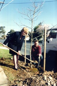
Photograph, Kaele Way
... She was also deputy chair man of the Victorian Regional Development for the Eastern Metropolitan area. In 2009 she was presented with an AM for her work for women in local government. ...She was also deputy chair man of the Victorian Regional Development for the Eastern Metropolitan area. In 2009 she was presented with an AM for her work for women in local government. ...Always immaculately groomed councillor Kaele Way was a keen advocate for woman in local government. in 2005 she was elected to the Springfield ward. In 2007 she was inducted into the Victorian Honour Roll for Women. She was one of only 20 at the time. In 2008 she co-authored a handbook for women for wishing to run for office. In2008 she became chair of the Australian Local Government Womens Association. In 2009 she became deputy chair of the Victorian Regional Development Association. She was also deputy chair man of the Victorian Regional Development for the Eastern Metropolitan area. In 2009 she was presented with an AM for her work for women in local government. Kaele Way died in July 2011Coloured photo of Whitehorse councillor Kaele Way planting a tree on a Whitehorse nature strip. A man is assistingway kaele, councillors -
 Wodonga & District Historical Society Inc
Photograph - Mann Collection Album - Dunstan's Corner, Wodonga, C. 1970s
... A large proportion of the company's timber output was processed at the Wodonga yards into flooring, weatherboards, mouldings etc. and practically the whole output was distributed locally and throughout the Riverina and eastern areas of New South Wales, and Canberra. ...A large proportion of the company's timber output was processed at the Wodonga yards into flooring, weatherboards, mouldings etc. and practically the whole output was distributed locally and throughout the Riverina and eastern areas of New South Wales, and Canberra. ...These town photos are part of a collection donated by Elaine Mann. Elaine was married to David Mann, a successful Wodonga businessman and community leader who passed away in Wodonga in June 2012. David was a member of the Mann family who began their business in Wodonga in 1920. Elaine was a teacher in Wodonga for many years and an active member of the community. Arthur Dunstan Hardware Arthur Dunstan established mills at Red Bluff on the Mitta and a timber yard at Wodonga. He also built a sawmill at Glen Wills in 1931 which operated for about 16 years. A larger and more modern sawmill with drying kilns was erected at Eskdale in 1947. He was contracted to build Wodonga’s Municipal sale yards in 1935, followed by the Wangaratta sale yards. This created so many forward orders that he bought a large block of land on the corner of Beechworth and Tallangatta Roads and opened a timber mill and hardware store. The business stood on this corner for about 40 years. A large proportion of the company's timber output was processed at the Wodonga yards into flooring, weatherboards, mouldings etc. and practically the whole output was distributed locally and throughout the Riverina and eastern areas of New South Wales, and Canberra. At its peak Dunstan’s was one of the biggest sawmilling businesses in Victoria and in Wodonga employed 150 people and milled l6,000,000 super feet of timber annually. A super foot is a measurement for timber, equal to one foot square by one inch thick. Arthur Dunstan also built Tower Place in High Street. He died in Wodonga in 1963 and the business was continued on by his sons. Dunstan’s timber yards in Wodonga were sold to Ezerd Industries in 1987 with the retail section being bought by BBC Hardware.This photo collection is of significance as it documents how the businesses and buildings in Wodonga have evolved and contributed to community throughout the late 20th century. A. Dunstan & Sons Hardware was located at the roundabout on the corner of High Street and Thomas Mitchell Drive (Formerly Tallangatta Road). "Southside Terrace" now occupies this site.wodonga businesses, high st wodonga, dunstan's hardware wodonga -
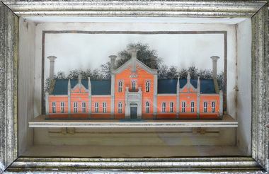 Creswick Museum
Model Building, circa 1869
... The 1857 survey map of the proposed township shows the area at Eastern Hills reserved for a hospital and Benevolent Society...The 1857 survey map of the proposed township shows the area at Eastern Hills reserved for a hospital and Benevolent Society The model's unique association with the Lindsay Artist of Creswick. ...Rev. Thomas Williams was grandfather of the Lindsay children. He is credited with encouraging his grandchildren in their artistic talents. Both Lionel and Normam learnt their model making skills from him. Creswick Hospital was foundation stone was laid in 1863. It operated as a hospital until 1911 when it was sold to the government as part of the School of Forestry (now University of Melbourne). The model shows it as a red brick building. In the 1870s it was painted as a white building. The Museum has b/w photos of the building taken prior to rendering. The people of Creswick collected fund for the project and obtained a government grant. The 1857 survey map of the proposed township shows the area at Eastern Hills reserved for a hospital and Benevolent SocietyThe model's unique association with the Lindsay Artist of Creswick. Model of Creswick Hospital before rendering. Made of paper with painted background and framed.model, creswick hospital, rev t. williams, lindsay family -
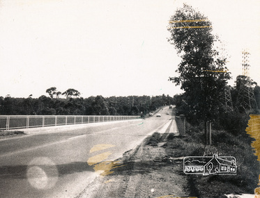
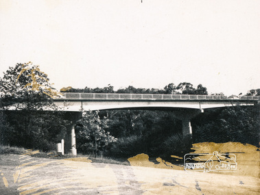
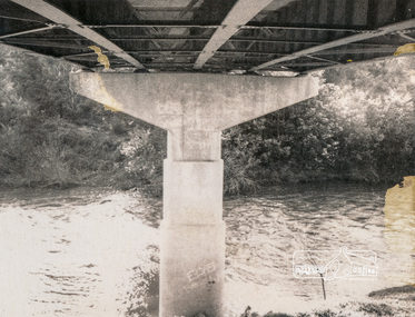
 Eltham District Historical Society Inc
Photograph, Fitzsimons Lane Bridge over Yarra River between Eltham and Templestowe, c.1966, 1966c
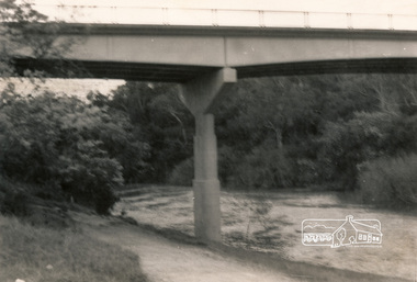
... It will be some time yet before most people work out the possibilities in shorter and quicker trips form the north-eastern areas to the eastern and south-eastern suburbs. ...It will be some time yet before most people work out the possibilities in shorter and quicker trips form the north-eastern areas to the eastern and south-eastern suburbs. ...The bridge over the Yarra River was initially opened September 22nd, 1961. Newspaper reports at the time of opening stated it linked Bolton Street, Eltham, with Fitzsimons Lane, Templestowe. In 1955 the Country Roads Board (CRB) produced survey plans that showed proposed land acquisition for the future bridge and road approaches. The 1955 plan shows that it was proposed to connect Fitzsimons Lane with Bolton Street in Eltham by a diagonal road across the river. The road connection would then continue along Bolton Street to Main Road. Prior to construction of the bridge the CRB modified the proposal significantly so that there was a new road parallel with Bolton Street and then curving to join Main Road at what was then its intersection with Old Eltham Road. This involved significantly more land acquisition and altered the pattern of land subdivision through this corridor. Initially the new road was just a single two-way carriageway as it would have required a significant widening of the cutting on the Shire of Eltham side of the river. The road was officially un-named but was known locally as the Eltham-Templestowe Road. The 1966 Melway street directory and other 1960s editions also listed the road as the Eltham-Templestowe Road. In December 1970, Eltham Shire Council, in pursuance of the provisions of the Local Government Act, named it Templestowe Road. The road was renamed Fitzsimons Lane around 1984 in conformity with the section south of the river. In 1991 a new bridge was built to the west of the original bridge. Fitzsimons Lane was widened to four traffic lanes although on the Eltham side this was done within the limits of the existing cutting. NEW BRIDGE STARTS THEM EXPLORING Without any fanfares, Country Roads Board workmen on Friday afternoon put the finishing touches to the approaches, removed the barricades, and let the traffic roll over the new Yarra bridge linking Bolton Street, Eltham, with Fitzsimons Lane, Templestowe. Over the week-end many “bridge watchers” who were making one of their periodic inspections of the progress on the new bridge found to their surprise that they could drive over it, so that people who had gone for a run out to Eltham suddenly found themselves wandering through Templestowe and Doncaster. By Monday the word of the bridge’s opening had got around sufficiently for many regular travellers to the city from Eltham and beyond to vary the monotony by going to town via Templestowe and Kew instead of through Heidelberg. They were surprised at the distances – about 3 ½ miles from Eltham to Templestowe, 6 miles from Eltham Shire hall to the Lower Heidelberg Road-Banksia Street intersection. NEW NEIGHBOURS For people on both sides of the river, the new bridge has turned distant friends into near neighbours. A Greensborough man on Sunday took 35 minutes to reach the home of a friend in East Doncaster, but the return trip over the new bridge took only 17 minutes. It will be some time yet before most people work out the possibilities in shorter and quicker trips form the north-eastern areas to the eastern and south-eastern suburbs. The coming of the warmer months will soon teach many, though the short cuts to Peninsular beaches and eastern suburban drive-ins. And before very long it is likely there will be a Tramways bus running from Templestowe to Eltham station. NEW BRIDGE STARTS THEM EXPLORING (1961, September 27). The Diamond Valley News (News clipping held in SEA_74-1_047) The previously un-named road between Main Road and Yarra River, Eltham South, east of Bolton Street was named Templestowe Road, December 15, 1970 NAMING OF STREETS AND ROADS. (1970, December 15). The Diamond Valley News (News clipping held in SEA_74-2_022)Black and white photographManufacturer's marks: Polaroid, Batch #J62K181 (Sep 1966).infrastructure, shire of eltham infrastructure, bridge, fitzsimons lane bridge, polaroid, yarra river -
 Eltham District Historical Society Inc
Photograph, Fitzsimons Lane Bridge over Yarra River between Eltham and Templestowe, c.1966, 1966c
... It will be some time yet before most people work out the possibilities in shorter and quicker trips form the north-eastern areas to the eastern and south-eastern suburbs. ...It will be some time yet before most people work out the possibilities in shorter and quicker trips form the north-eastern areas to the eastern and south-eastern suburbs. ...The bridge over the Yarra River was initially opened September 22nd, 1961. Newspaper reports at the time of opening stated it linked Bolton Street, Eltham, with Fitzsimons Lane, Templestowe. In 1955 the Country Roads Board (CRB) produced survey plans that showed proposed land acquisition for the future bridge and road approaches. The 1955 plan shows that it was proposed to connect Fitzsimons Lane with Bolton Street in Eltham by a diagonal road across the river. The road connection would then continue along Bolton Street to Main Road. Prior to construction of the bridge the CRB modified the proposal significantly so that there was a new road parallel with Bolton Street and then curving to join Main Road at what was then its intersection with Old Eltham Road. This involved significantly more land acquisition and altered the pattern of land subdivision through this corridor. Initially the new road was just a single two-way carriageway as it would have required a significant widening of the cutting on the Shire of Eltham side of the river. The road was officially un-named but was known locally as the Eltham-Templestowe Road. The 1966 Melway street directory and other 1960s editions also listed the road as the Eltham-Templestowe Road. In December 1970, Eltham Shire Council, in pursuance of the provisions of the Local Government Act, named it Templestowe Road. The road was renamed Fitzsimons Lane around 1984 in conformity with the section south of the river. In 1991 a new bridge was built to the west of the original bridge. Fitzsimons Lane was widened to four traffic lanes although on the Eltham side this was done within the limits of the existing cutting. NEW BRIDGE STARTS THEM EXPLORING Without any fanfares, Country Roads Board workmen on Friday afternoon put the finishing touches to the approaches, removed the barricades, and let the traffic roll over the new Yarra bridge linking Bolton Street, Eltham, with Fitzsimons Lane, Templestowe. Over the week-end many “bridge watchers” who were making one of their periodic inspections of the progress on the new bridge found to their surprise that they could drive over it, so that people who had gone for a run out to Eltham suddenly found themselves wandering through Templestowe and Doncaster. By Monday the word of the bridge’s opening had got around sufficiently for many regular travellers to the city from Eltham and beyond to vary the monotony by going to town via Templestowe and Kew instead of through Heidelberg. They were surprised at the distances – about 3 ½ miles from Eltham to Templestowe, 6 miles from Eltham Shire hall to the Lower Heidelberg Road-Banksia Street intersection. NEW NEIGHBOURS For people on both sides of the river, the new bridge has turned distant friends into near neighbours. A Greensborough man on Sunday took 35 minutes to reach the home of a friend in East Doncaster, but the return trip over the new bridge took only 17 minutes. It will be some time yet before most people work out the possibilities in shorter and quicker trips form the north-eastern areas to the eastern and south-eastern suburbs. The coming of the warmer months will soon teach many, though the short cuts to Peninsular beaches and eastern suburban drive-ins. And before very long it is likely there will be a Tramways bus running from Templestowe to Eltham station. NEW BRIDGE STARTS THEM EXPLORING (1961, September 27). The Diamond Valley News (News clipping held in SEA_74-1_047) The previously un-named road between Main Road and Yarra River, Eltham South, east of Bolton Street was named Templestowe Road, December 15, 1970 NAMING OF STREETS AND ROADS. (1970, December 15). The Diamond Valley News (News clipping held in SEA_74-2_022)Black and white photographManufacturer's marks: Polaroid, Batch #J62K181 (Sep 1966).infrastructure, shire of eltham infrastructure, bridge, fitzsimons lane bridge, polaroid, yarra river -
 Eltham District Historical Society Inc
Photograph, Fitzsimons Lane Bridge over Yarra River between Eltham and Templestowe
... It will be some time yet before most people work out the possibilities in shorter and quicker trips form the north-eastern areas to the eastern and south-eastern suburbs. ...It will be some time yet before most people work out the possibilities in shorter and quicker trips form the north-eastern areas to the eastern and south-eastern suburbs. ...The bridge over the Yarra River was initially opened September 22nd, 1961. Newspaper reports at the time of opening stated it linked Bolton Street, Eltham, with Fitzsimons Lane, Templestowe. In 1955 the Country Roads Board (CRB) produced survey plans that showed proposed land acquisition for the future bridge and road approaches. The 1955 plan shows that it was proposed to connect Fitzsimons Lane with Bolton Street in Eltham by a diagonal road across the river. The road connection would then continue along Bolton Street to Main Road. Prior to construction of the bridge the CRB modified the proposal significantly so that there was a new road parallel with Bolton Street and then curving to join Main Road at what was then its intersection with Old Eltham Road. This involved significantly more land acquisition and altered the pattern of land subdivision through this corridor. Initially the new road was just a single two-way carriageway as it would have required a significant widening of the cutting on the Shire of Eltham side of the river. The road was officially un-named but was known locally as the Eltham-Templestowe Road. The 1966 Melway street directory and other 1960s editions also listed the road as the Eltham-Templestowe Road. In December 1970, Eltham Shire Council, in pursuance of the provisions of the Local Government Act, named it Templestowe Road. The road was renamed Fitzsimons Lane around 1984 in conformity with the section south of the river. In 1991 a new bridge was built to the west of the original bridge. Fitzsimons Lane was widened to four traffic lanes although on the Eltham side this was done within the limits of the existing cutting. NEW BRIDGE STARTS THEM EXPLORING Without any fanfares, Country Roads Board workmen on Friday afternoon put the finishing touches to the approaches, removed the barricades, and let the traffic roll over the new Yarra bridge linking Bolton Street, Eltham, with Fitzsimons Lane, Templestowe. Over the week-end many “bridge watchers” who were making one of their periodic inspections of the progress on the new bridge found to their surprise that they could drive over it, so that people who had gone for a run out to Eltham suddenly found themselves wandering through Templestowe and Doncaster. By Monday the word of the bridge’s opening had got around sufficiently for many regular travellers to the city from Eltham and beyond to vary the monotony by going to town via Templestowe and Kew instead of through Heidelberg. They were surprised at the distances – about 3 ½ miles from Eltham to Templestowe, 6 miles from Eltham Shire hall to the Lower Heidelberg Road-Banksia Street intersection. NEW NEIGHBOURS For people on both sides of the river, the new bridge has turned distant friends into near neighbours. A Greensborough man on Sunday took 35 minutes to reach the home of a friend in East Doncaster, but the return trip over the new bridge took only 17 minutes. It will be some time yet before most people work out the possibilities in shorter and quicker trips form the north-eastern areas to the eastern and south-eastern suburbs. The coming of the warmer months will soon teach many, though the short cuts to Peninsular beaches and eastern suburban drive-ins. And before very long it is likely there will be a Tramways bus running from Templestowe to Eltham station. NEW BRIDGE STARTS THEM EXPLORING (1961, September 27). The Diamond Valley News (News clipping held in SEA_74-1_047) The previously un-named road between Main Road and Yarra River, Eltham South, east of Bolton Street was named Templestowe Road, December 15, 1970 NAMING OF STREETS AND ROADS. (1970, December 15). The Diamond Valley News (News clipping held in SEA_74-2_022)Black and white photographinfrastructure, shire of eltham infrastructure, bridge, fitzsimons lane bridge, yarra river