Showing 25 items matching "edithvale"
-
 Chelsea & District Historical Society Inc
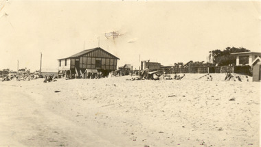
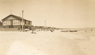
Photograph - Edithvale Life-Saving Club, 1940's-1950's
... ...Edithvale...Edithvale Life Saving Club was founded in 1919....Black and white postcard of Edithvale Life-Saving Club, a double story wooden building, built on the foreshore of Edithvale beach....Tainsh Series No 1 The Beach Edithvale Printed on back: A real photograph. ...Life saving club Edithvale Edithvale beach Tainsh Series No 1 The Beach Edithvale Printed on back: A real photograph. ...Edithvale Life Saving Club was founded in 1919.Black and white postcard of Edithvale Life-Saving Club, a double story wooden building, built on the foreshore of Edithvale beach.Tainsh Series No 1 The Beach Edithvale Printed on back: A real photograph. Produced in Australia Handwritten on back: 4th July 1942, Edithvalelife saving club, edithvale, edithvale beach -
 Chelsea & District Historical Society Inc
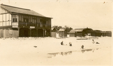
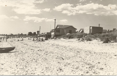
Photograph - Edithvale Life-Saving Club, Clubhouse, 1920's - 1930's
... ...Edithvale...Edithvale Life Saving Club was founded in 1919....Sepia postcard of Edithvale Life-Saving Club, a double story wooden building, built on the foreshore of Edithvale beach. ...Kiosk and beach, Edithvale Valentine series no 198...Life saving club Edithvale Edithvale beach bathing boxes Kiosk and beach, Edithvale Valentine series no 198 Sepia postcard of Edithvale Life-Saving Club, a double story wooden building, built on the foreshore of Edithvale beach. ...Edithvale Life Saving Club was founded in 1919.Sepia postcard of Edithvale Life-Saving Club, a double story wooden building, built on the foreshore of Edithvale beach. Bathing boxes are on the right hand side, with boats sitting on the sand and three children playing, while a man watches.Kiosk and beach, Edithvale Valentine series no 198life saving club, edithvale, edithvale beach, bathing boxes -
 Chelsea & District Historical Society Inc
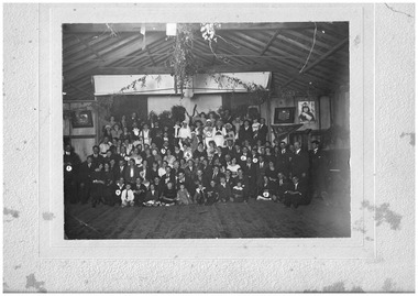
Photograph - Fancy Dress Ball, Edithvale Boat Club, c 1923
... Edithvale Boat Club...Fancy Dress Ball held at Edithvale Boat Club....A photograph of men, women and children attending a fancy dress bal at Edithvale Boat Club. On the rear of the photo ten people have been identified: 1 - Mr Case; 2 - Mr and Mrs Plain (owner of the Unity Theatre); 3 - Mr Rowe; 4 - Mrs Bert Smith; 5 - Alf Case; 6 - Sid Munro; 7 - Bert Richardson; 8 - Marg Upton; 9 - Nellie Cameron; 10 - Arthur Upton. ...Edithvale Boat Club Photograph Fancy Dress Ball ...Fancy Dress Ball held at Edithvale Boat Club.A photograph of men, women and children attending a fancy dress bal at Edithvale Boat Club. On the rear of the photo ten people have been identified: 1 - Mr Case; 2 - Mr and Mrs Plain (owner of the Unity Theatre); 3 - Mr Rowe; 4 - Mrs Bert Smith; 5 - Alf Case; 6 - Sid Munro; 7 - Bert Richardson; 8 - Marg Upton; 9 - Nellie Cameron; 10 - Arthur Upton. F. Cumming Studio. Frankston Road, Chelseacarrum, chelsea, carrum mechanics hall, fancy dress ball, social function, clothing -
 Chelsea & District Historical Society Inc
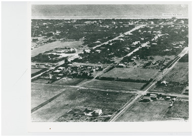
Photograph - Aerial Photo of Edithvale
... ...Edithvale...Edithvale Boat house was opened in 1918. ...The Edithvale Boat Shed can be seen on the foreshore. ...Chelsea & District Historical Society Inc The Chelsea Activity Hub 3-5 Showers Ave Chelsea 3196 melbourne Edithvale Boat house was opened in 1918. Chelsea Aerial photo Edithvale Boat House Edithvale Black and white aerial photo of Edithvale. ...Edithvale Boat house was opened in 1918. Black and white aerial photo of Edithvale. It shows open paddocks, houses, unmade roads. The Edithvale Boat Shed can be seen on the foreshore. chelsea, aerial photo, edithvale boat house, edithvale -
 Chelsea & District Historical Society Inc
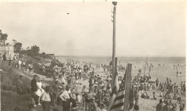
Photograph - Edithvale Life-Saving Club, Clubhouse, 1940's
... ...Edithvale...Edithvale Life Saving Club was founded in 1919....Sepia postcard of Edithvale Life-Saving Club, a double story wooden building, built on the foreshore of Edithvale beach. ...Life saving club Edithvale Edithvale beach Sepia postcard of Edithvale Life-Saving Club, a double story wooden building, built on the foreshore of Edithvale beach. ...Edithvale Life Saving Club was founded in 1919.Sepia postcard of Edithvale Life-Saving Club, a double story wooden building, built on the foreshore of Edithvale beach. People are sitting the beach, some under sun umbrellas.life saving club, edithvale, edithvale beach -
 Chelsea & District Historical Society Inc
Photograph - Edithvale Life-Saving Club, Clubhouse
... ...Edithvale...Edithvale Life Saving Club was founded in 1919....Sepia postcard of Edithvale Life-Saving Club, a double story wooden building, built on the foreshore of Edithvale beach. ...Life saving club Edithvale Edithvale beach Sepia postcard of Edithvale Life-Saving Club, a double story wooden building, built on the foreshore of Edithvale beach. ...Edithvale Life Saving Club was founded in 1919.Sepia postcard of Edithvale Life-Saving Club, a double story wooden building, built on the foreshore of Edithvale beach. People are sitting the beach, some under sun umbrellas.life saving club, edithvale, edithvale beach -
 Chelsea & District Historical Society Inc
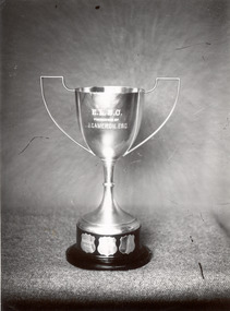
Photograph - Edithvale Life-Saving Club Trophy
... ...Edithvale...Edithvale Life Saving Club was founded in 1919....Two black and white photos of the Edithvale Life-Saving Club Cup and a photo of a young boy from Edithvale Life-Saving Club, holding the trophy....Life saving club Edithvale Edithvale beach Edithvale Life Saving Club Cup E.L.S.C. ...Edithvale Life Saving Club was founded in 1919.Two black and white photos of the Edithvale Life-Saving Club Cup and a photo of a young boy from Edithvale Life-Saving Club, holding the trophy.E.L.S.C. PRESENTED BY J. CAMERRON. ESQ.life saving club, edithvale, edithvale beach, edithvale life saving club cup -
 City of Kingston
Photograph - Colour, Circa 1993
... Edithvale...Edithvale is a suburb in the City of Kingston. ...Aerial colour photograph of Edithvale as viewed from Alexandra Avenue in the north to Ella Grove Chelsea/Edithvale in the south. ...City of Kingston Parkdale Library 96 Parkers Road, Parkdale Parkdale Edithvale is a suburb in the City of Kingston. ...Edithvale is a suburb in the City of Kingston. It is located between Aspendale and Chelsea on the Port Phillip Bay and built within remnant areas of the Carrum Carrum swamp. The foreshore precinct comprises a wide sandy beach, with low sand dunes and numerous historic boat sheds. The suburb consists of older style dwellings and former holiday houses, combined with mid-century housing and newer homes. The large blocks are increasingly subdivided and the existing dwellings demolished to accommodate units and townhouses, thus changing the landscape of the area and reducing the tree canopy.The beachside suburb of Edithvale was previously part of the extensive Carrum Carrum Swamp. The area was once a source of fish and eels for the Mayone-Bulluk clan of the Bunurong people. Over time the area was drained and predominantly devoted to dairy farming and holiday houses. The farms were gradually sold and subdivided with a large number of homes built after World War II and in the 1960s. Edithvale is mainly residential with a shopping strip along Nepean Highway but little significant industry was ever established in the area apart from a plaster works and confectionary factory, both now closed.Aerial colour photograph of Edithvale as viewed from Alexandra Avenue in the north to Ella Grove Chelsea/Edithvale in the south. The area is built-up with residential housing and facilities including Edithvale Primary School, numerous churches and the Edithvale Railway station. Large sections depict the remnant Carrum Carrum swamp. Edithvale Common and the former "Duck Inn" (Melbourne Water/Friends of Edithvale Seaford Wetlands) can be seen. Edithvale Recreational reserve, the velodrome and Edithvale Public Golf Course are prominent. The image shows vacant land in the area now known as Aspendale Gardens and the newer residential section of Chelsea Heights is not developed. A bike path has been established to cover the secondary drain. The Golf Links Court residential development located off Hughes Avenue is a large vacant block.Yellow circular adhesive sticker on plastic Black ink (marker): * (asterisk) Black type on white adhesive sticker: P000108edithvale, aspendale, chelsea, carrum carrum swamp -
 Chelsea & District Historical Society Inc
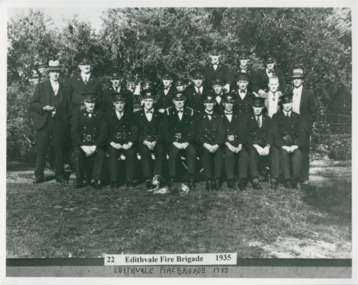
Photograph - Edithvale Fire Brigade Members, 1935
... ...Edithvale...A group photo of the members of the Edithvale Fire Station. Back Row (L-R) Doug McLeith, Johnnie Graham, Freddie Wagg. ...Black and white photo of the members of the Edithvale Fire Station...Fire Brigade Firefighters Edithvale Fire Brigade Edithvale Black and white photo of the members of the Edithvale Fire Station Photograph Edithvale Fire Brigade Members ...A group photo of the members of the Edithvale Fire Station. Back Row (L-R) Doug McLeith, Johnnie Graham, Freddie Wagg. Middle Row (L- R) Fred Beeson, Jack Rodgers, Freddie Jackson, George Graham, Col Howitt, Ron Flanagan, Les Payne, Peter Turner, Snowy White, Fred Beaumont. Front Row (L-R) Bill Grant, Jimmie Mudge, Bill Brothwell, Arthur Cooper (Captain), Ern Mapperson, Gil Joy, Ed Brothwell, Harry Beeson. Black and white photo of the members of the Edithvale Fire Stationfire brigade, firefighters, edithvale fire brigade, edithvale -
 Chelsea & District Historical Society Inc
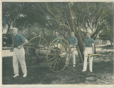
Photograph - Edithvale Fire Brigade, "C" Class Fours, March 1935
... ...Edithvale...This photo was taken at the Fireman's Contest in Ballarat , March 1935. Edithvale won the C Class hose fours. Bill Broothwell (pole), Ron Flanagan (hydrant) Perc Steele (coupling) and Gill Joy (branch)...Black and White Photo that has been hand coloured of four members of the Edithvale Fire Station with their fire equipment...Chelsea & District Historical Society Inc The Chelsea Activity Hub 3-5 Showers Ave Chelsea 3196 melbourne This photo was taken at the Fireman's Contest in Ballarat , March 1935. Edithvale won the C Class hose fours. Bill Broothwell (pole), Ron Flanagan (hydrant) Perc Steele (coupling) and Gill Joy (branch) Fire Brigade Contest Fireman Edithvale Chelsea fire equipment firefighting Emergency Services Black and White Photo that has been hand coloured of four members of the Edithvale Fire Station with their fire equipment "C" Class Fours Photograph Edithvale Fire Brigade ...This photo was taken at the Fireman's Contest in Ballarat , March 1935. Edithvale won the C Class hose fours. Bill Broothwell (pole), Ron Flanagan (hydrant) Perc Steele (coupling) and Gill Joy (branch)Black and White Photo that has been hand coloured of four members of the Edithvale Fire Station with their fire equipmentfire brigade, contest, fireman, edithvale, chelsea, fire equipment, firefighting, emergency services -
 Chelsea & District Historical Society Inc
Photograph - Edithvale Life-Saving Club, 1940's-1950's
... ...Edithvale...Edithvale Life Saving Club was founded in 1919....Life saving club Edithvale Black and white photo of presentation of awards. ...Edithvale Life Saving Club was founded in 1919.Black and white photo of presentation of awards. The photo was taken looking towards Chelsea. A toilet block sits on the hill on the left.life saving club, edithvale -
City of Kingston
Photograph - Colour, 6 March 1993
... Edithvale is a suburb in the City of Kingston. ...Laminated aerial colour photograph of Edithvale as viewed from Alexandra Avenue in the north to Ella Grove Chelsea/Edithvale in the south. regents Park Aspendale can be seen in the top left. ...City of Kingston Parkdale Library 96 Parkers Road, Parkdale Parkdale Edithvale is a suburb in the City of Kingston. ...Edithvale is a suburb in the City of Kingston. It is located between Aspendale and Chelsea on the Port Phillip Bay and built within remnant areas of the Carrum Carrum swamp. The foreshore precinct comprises a wide sandy beach, with low sand dunes and numerous historic boat sheds. The suburb consists of older style dwellings and former holiday houses, combined with mid-century housing and newer homes. The large blocks are increasingly subdivided and the existing dwellings demolished to accommodate units and townhouses, thus changing the landscape of the area and reducing the tree canopy.The beachside suburb of Edithvale was previously part of the extensive Carrum Carrum Swamp. The area was once a source of fish and eels for the Mayone-Bulluk clan of the Bunurong people. Over time the area was drained and predominantly devoted to dairy farming and holiday houses. The farms were gradually sold and subdivided with a large number of homes built after World War II and in the 1960s. Edithvale is mainly residential with a shopping strip along Nepean Highway but little significant industry was ever established in the area apart from a plaster works and confectionary factory, both now closed.Laminated aerial colour photograph of Edithvale as viewed from Alexandra Avenue in the north to Ella Grove Chelsea/Edithvale in the south. regents Park Aspendale can be seen in the top left. The area is built-up with residential housing and facilities including Edithvale Primary School, numerous churches and the Edithvale Railway station. Large sections depict the remnant Carrum Carrum swamp. Edithvale Common and the former "Duck Inn" (Melbourne Water/Friends of Edithvale Seaford Wetlands) can be seen. Edithvale Recreational reserve, the valodrome and Edithvale Public Golf Course are prominent. The image shows vacant land in the area now known as Aspendale Gardens and the newer residential section of Chelsea Heights is not developed. A bike path has been established to cover the secondary drain. The Golf Links Court residential development located off Hughes Avenue is a large vacant block.Black type on white adhesive label: 6-3-93 Black type on white adhesive label: 25/9211, 6/3/93, 11.20 am Black type on white adhesive label: 9211 Yellow circular adhesive sticker Black pencil: 9211 6-3-93 arrow pointing Nedthvale, carrum carrum swamp, aspendale, chelsea -
 Chelsea & District Historical Society Inc
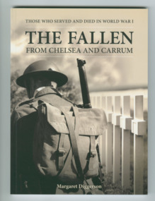
Book - The Fallen: From Chelsea and Carrum - printed 2014, Margaret Diggerson, The Fallen: From Chelsea and Carrum
... Chelsea, Aspendale, Edithvale, Bonbeach and Carrum, Victoria ...Accounts of the lives of WW1 soldiers from Chelsea and districtSmall soft cover booknon-fictionAccounts of the lives of WW1 soldiers from Chelsea and districtlocal men of chelsea who served in ww1 -
 Dandenong/Cranbourne RSL Sub Branch
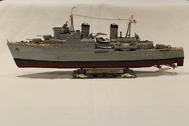
Model - Plastic model of ship, 1996 by Ken Moore
... Field Avenue, Edithvale. 3196, Victoria, Australia ...Plastic model of HMS Ceylon. British Light - Cruiser. Battle honours Dardanelles - Sabang and Burma. Motto "To Fight the Proud".H.M.S CEYLON. Korea 1950. -
 Chelsea & District Historical Society Inc
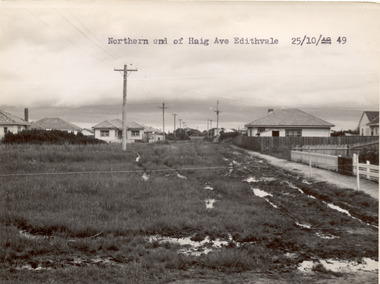
Photograph - Haig Avenue, Edithvale, 1949
... ...Edithvale...Two black and white photo of the northern and southern ends of Haig Avenue, Edithvale. The road is unmade with grass growing on the road, is rutted with large puddles, houses line both sides and electricity poles are both side of the road. ...Photograph Haig Avenue, Edithvale ...This photo is one of a collection of photos taken during Alan Niemann's - Drainage-Road Making Scheme.Two black and white photo of the northern and southern ends of Haig Avenue, Edithvale. The road is unmade with grass growing on the road, is rutted with large puddles, houses line both sides and electricity poles are both side of the road. unmade street, aspendale, alan niemann, drainage-road making scheme, haig avenue, edithvale -
 City of Kingston
Photograph - Colour, 30 July 2000
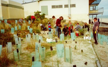
... Handwritten in black ink: National Tree Day / 30 July 2000 / Bon Beach? / Edithvale?...Ocean Trees Environment Volunteers Handwritten in black ink: National Tree Day / 30 July 2000 / Bon Beach? / Edithvale? Colour photograph of a gropu of people on a beach foreshore with a building (presumably surf life saving club) in the background. ...This photograph depicts workers/volunteers participating in tree planting on the foreshore as part of National Tree Day. It is uncertain which beach is it.Colour photograph of a gropu of people on a beach foreshore with a building (presumably surf life saving club) in the background. In front of the group are a many freshly planted trees surrounded by ground steaks and green plastic sheeting.Handwritten in black ink: National Tree Day / 30 July 2000 / Bon Beach? / Edithvale?ocean, trees, environment, volunteers -
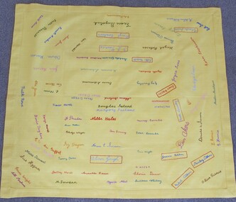
 Uniting Church Archives - Synod of Victoria
Banner - Two piece banner
... Panel 1: "EDITHVALE SUNDAY SCHOOL" Panel 2: "LADIES GUILD 1926-1988" "DELTA GUILD 1958-1988" "UCF 1989"...Uniting Church Archives - Synod of Victoria 54 Serrell Street Malvern East melbourne Edithvale Sunday School Edithvale Uniting Church Fellowship Edithvale Uniting Church Fellowship Ladies Guild Edithvale Uniting Church Fellowship Delta Guild Panel 1: "EDITHVALE SUNDAY SCHOOL" Panel 2: "LADIES GUILD 1926-1988" "DELTA GUILD 1958-1988" "UCF 1989" Two rectangular panels made of cream calico joined to form one banner with pale blue satin ribbon. ...Two rectangular panels made of cream calico joined to form one banner with pale blue satin ribbon. Each panel is decorated with fabric paint.Panel 1: "EDITHVALE SUNDAY SCHOOL" Panel 2: "LADIES GUILD 1926-1988" "DELTA GUILD 1958-1988" "UCF 1989"edithvale sunday school, edithvale uniting church fellowship, edithvale uniting church fellowship ladies guild, edithvale uniting church fellowship delta guild -
City of Kingston
Photograph - Colour, 29 January 1993
... The suburb borders the Edithvale-Seaford Wetlands which is the remnant site of the Carrum Carrum swamp, once the home of the Bunurong people....Landmarks include St Joseph's Church and Primary School, Chelsea Primary School, Bonbeach Station, Bonbeach Fotball Club sports playing fields and Bonbeach Life Saving Club. The Edithvale Wetlands is featured prominently to the right-hand side of the image. ...The suburb borders the Edithvale-Seaford Wetlands which is the remnant site of the Carrum Carrum swamp, once the home of the Bunurong people. ...Bonbeach is a small beachside suburb located between Chelsea and Carrum. The station was opened in 1926 and was the last to be established in the group from Aspendale to Carrum. Urban growth began after World War II. State primary and high schools were opened in 1958 on land in Breeze Street that was once occupied by The Australian Glass Manufacturers. Immediately east of the school sites is the Patterson River Golf Club. The Bonbeach sports reserve has five ovals and is home to the Bonbeach football and baseball clubs. The suburb borders the Edithvale-Seaford Wetlands which is the remnant site of the Carrum Carrum swamp, once the home of the Bunurong people.Bonbeach was originally a seaside destination for holidaymakers and the housing comprised of holiday homes and gradually more permanent residents. It was not until 1926 that Bonbeach had its own railway station. From 1906 until the late 1940s sand was quarried on the east side of the railway line and used in the manufacture of glass. The Australian Glass Manufacturers sold this land in residential blocks and Bonbeach's permanent population spread from the coastal strip across to the other side of the railway line. Laminated colour aerial photograph of the suburb of Bonbeach and also the southern section of neighbouring Chelsea within the City of Kingston. The extent of this 1993 aerial image includes: Top left - Maury Road at the south end of the Chelsea shopping Centre; Top right - Scotch Parade Chelsea Bottom left - Monica Avenue in Bonbeach; Bottom right - Patterson River Golf Club. Landmarks include St Joseph's Church and Primary School, Chelsea Primary School, Bonbeach Station, Bonbeach Fotball Club sports playing fields and Bonbeach Life Saving Club. The Edithvale Wetlands is featured prominently to the right-hand side of the image. Black typed writing on white adhesive label: No. 6662 Black typed writing on white adhesive label: 26E/6662, 29/1/93, 4.25 pm Black typed writing on white adhesive label: 29-1-93 Black typed writing on white adhesive label: P000109 Circular yellow adhesive sticker bonbeach, chelsea -
 Chelsea & District Historical Society Inc
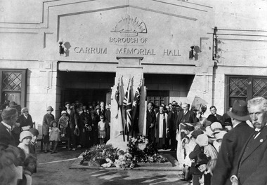
Photograph - Borough of Carrum Memorial Hall, Unveiling of the Memorial Cenotaph, 3 April 1927
... Mappin, Church of England, Edithvale assisted by Rev. Pastor McOrmish Congregational, Mr Collins Presbyterian Edithvale and Commandant Lucas Salvation Army....Mappin, Church of England, Edithvale assisted by Rev. Pastor McOrmish Congregational, Mr Collins Presbyterian Edithvale and Commandant Lucas Salvation Army. ...The Carrum Memorial Hall was opened on 5 December 1925. In 1929 the name was changed to Chelsea Memorial Hall when Chelsea was proclaimed a city. The building was in use until 1963. The unveiling of the cenotaph Chelsea by Gen. H. E. "Pompey" Elliot. Photo taken by Comrade R. Monett whilst the crowd was still in attendance. Attended by Rev. J.R. Mappin, Church of England, Edithvale assisted by Rev. Pastor McOrmish Congregational, Mr Collins Presbyterian Edithvale and Commandant Lucas Salvation Army.A black and white photo of people standing in front of the Carrum Memorial Hall, situated in Station Street, Chelsea.The cenotaph has three flags with floral arrangements at the base.borough of carrum memorial hall, chelsea memorial hall, chelsea -
 Chelsea & District Historical Society Inc
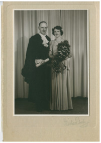
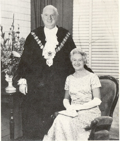
Photograph - City of Chelsea, Mayor Les and Phyllis Payne, 1947
... Les owned the General Store in Point Nepean Rd (Nepean Hwy) near Kelvin Grove, Chelsea and was a volunteer with the Edithvale Fire Brigade and a prominent member of the Edithvale Methodist Church. ...Les owned the General Store in Point Nepean Rd (Nepean Hwy) near Kelvin Grove, Chelsea and was a volunteer with the Edithvale Fire Brigade and a prominent member of the Edithvale Methodist Church. ...Les Payne (1908-1987) arrived in the area in 1924 and was a well known local identity who served on Chelsea Council from 1943 until his retirement in 1979. He was elected Mayor six times (in 1946/47, 53/54, 64/65, 67/68, 69/70, 75/76). Les owned the General Store in Point Nepean Rd (Nepean Hwy) near Kelvin Grove, Chelsea and was a volunteer with the Edithvale Fire Brigade and a prominent member of the Edithvale Methodist Church. In 1935 he married Phyllis (nee Baker).Black and white photo of Mayor Les Payne, dressed in Mayoral robes, standing beside his wife, Phyllis Payne who is in full evening dress.chelsea council, mayor, les payne, phyllis payne, chelsea -
 Chelsea & District Historical Society Inc
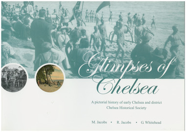
Book, G.Whitehead, Glimpses of Chelsea, 2007
... ...Edithvale...Aspendale Carrum Bonbeach Edithvale Chelsea A pictorial history of early Chelsea & District first printed 2007 Large soft cover book Glimpses of Chelsea Book Book G.Whitehead M Jacobs R Jacobs ...Photos and descriptions of historical buildings Chelsea District Historical Society is fortunate to have many photos that have been donated and collated over the last fifty years. In the early years our beachside suburb was popular with groups and families. Camping & holidaying in guest houses or privately rented houses. This book includes photographs of local people, beaches, churches, clubs, sports, hotels, railways, industry, hospitals and halls, and many other pictures of local scenes. A unique history of the District of Chelsea. Photographs show the beginnings and how the Chelsea district was developed. Various Sporting clubs and groups, businesses, buildings, streets and early European settlers and others. Large soft cover book A pictorial history of early Chelsea & District first printed 2007aspendale, carrum, bonbeach, edithvale, chelsea -
 Chelsea & District Historical Society Inc
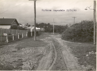
Photograph - Fifth Avenue, Aspendale, 1949
... ...Edithvale...Chelsea & District Historical Society Inc The Chelsea Activity Hub 3-5 Showers Ave Chelsea 3196 melbourne This photo is one of a collection of photos taken during Alan Niemann's - Drainage-Road Making Scheme. unmade street Aspendale Alan Niemann Drainage-Road Making Scheme Edithvale Fifth Avenue Black and white photo of Fifth Avenue, Aspendale. ...This photo is one of a collection of photos taken during Alan Niemann's - Drainage-Road Making Scheme.Black and white photo of Fifth Avenue, Aspendale. The road is unmade with grass growing on the road, is rutted, houses can be seen on the left and electricity poles are both side of the road. unmade street, aspendale, alan niemann, drainage-road making scheme, edithvale, fifth avenue -
 Chelsea & District Historical Society Inc
Photograph - City of Chelsea, Mayor Les and Phyllis Payne
... Les owned the General Store in Point Nepean Rd (Nepean Hwy) near Kelvin Grove, Chelsea and was a volunteer with the Edithvale Fire Brigade and a prominent member of the Edithvale Methodist Church. ...Les owned the General Store in Point Nepean Rd (Nepean Hwy) near Kelvin Grove, Chelsea and was a volunteer with the Edithvale Fire Brigade and a prominent member of the Edithvale Methodist Church. ...Les Payne (1908-1987) arrived in the area in 1924 and was a well known local identity who served on Chelsea Council from 1943 until his retirement in 1979. He was elected Mayor six times (in 1946/47, 53/54, 64/65, 67/68, 69/70, 75/76). Les owned the General Store in Point Nepean Rd (Nepean Hwy) near Kelvin Grove, Chelsea and was a volunteer with the Edithvale Fire Brigade and a prominent member of the Edithvale Methodist Church. In 1935 he married Phyllis (nee Baker). Chelsea was originally part of the Shire of Dandenong, and was severed and incorporated as the Borough of Carrum in May 1920. It was proclaimed the City of Chelsea on 8 May 1929. On 15 December 1994, the City of Chelsea was abolished, and along with the City of Mordialloc and parts of the Cities of Moorabbin, Oakleigh and Springvale, was merged into the newly created City of Kingston. Council meetings were held at Chelsea Town Hall at 316 Station Street, Chelsea. It presently serves as a council service centre and library for the City of Kingston.Black and white photo of Mayor Les Payne, dressed in Mayoral robes, standing beside his wife, Phyllis Payne who is seated on a velvet chair in full evening dress.chelsea council, mayor, les payne, phyllis payne, chelsea -
 Kew Historical Society Inc
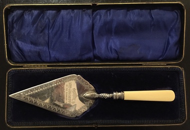
Ceremonial object - Presentation Trowel, Kew Baptist Church School Hall, Phillip Ashberry & Sons, 1905
... [The trowel in its case was presented to the Kew Historical Society on 24 April 2018 by the Manager of Bupa Aged Care, Edithvale.]...[The trowel in its case was presented to the Kew Historical Society on 24 April 2018 by the Manager of Bupa Aged Care, Edithvale.] Ceremonial object Presentation Trowel, Kew Baptist Church School Hall Phillip Ashberry & Sons ..."Infant Department The interest in this branch of the school work (under the able guidance of Misses F. Chapman and A.E. Ratten) is well maintained. It is largely through the generosity of Nr. and Mrs. Griffiths that the officers were enabled to have a new brick school hall built. The foundation stone was laid on 21st October, 1905, by Mrs. John M. Griffiths, the new building being erected on the site of the old church. It is both attractive and comfortable and is well lighted. It is also used for the week-night services. The old building which for so long had served as a schoolroom for the little ones was not considered suitable and was in 1905 disposed of for removal. When removed it was renovated, and is now used as a mission church in a neighbouring district." Source: Kew Baptist Church History 1856-1906The trowel is historically significant for its association with the Kew Baptist Church and its ownership by and association with the Griffiths family of Kew who were important tea merchants in Australia.Silver-plated commemorative trowel with bone handle, in black leather case lined with blue velvet. The trowel is engraved with information about the occasion.It was presented to Mrs J.M. Griffiths, who lived at Goldthorns, Normanby Road, Kew. [The trowel in its case was presented to the Kew Historical Society on 24 April 2018 by the Manager of Bupa Aged Care, Edithvale.]Engraved front: "Presented to Mrs. J.M. Griffiths on the occasion of her laying the foundation stone of the Baptist School Hall, Kew, Oct 21st 1905". Maker mark on reverse: "PA & S E P"griffiths family - kew (vic), mrs. j.m. griffiths, commemorative objects, baptist church (kew), presentation trowels -
 Uniting Church Archives - Synod of Victoria
Textile - Tablecloth
... Uniting Church Archives - Synod of Victoria 54 Serrell Street Malvern East melbourne Edithvale Uniting Church Fellowship Square coarse cotton mustard coloured tablecloth with names embroidered at random in coloured thread. ...Square coarse cotton mustard coloured tablecloth with names embroidered at random in coloured thread.edithvale uniting church fellowship