Showing 13 items matching "elevated tracks"
-
 Melbourne Tram Museum
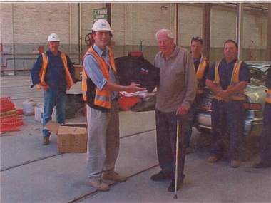
Photograph - Malvern Depot shed refurbishment 2002, 2002
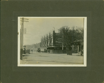
... ...elevated tracks...Six photographs show the removal of the pits under the elevated tracks and the reconstruction of the roads to street level. ...Six photographs show the removal of the pits under the elevated tracks and the reconstruction of the roads to street level. ...Photographs show refurbishment works to one of the car sheds at Malvern Depot between June and November 2002. Two of the nine photographs show some of the workers along with retired union delegate Norm Maddock. One photograph shows wall frames for an office. Six photographs show the removal of the pits under the elevated tracks and the reconstruction of the roads to street level. The works occurred three years into the franchise of Swanston Trams (later M Tram) in preparation for the introduction of low floor D class Siemens Combino trams.Yields information about depot reconstruction at malvern Depot before arrival of D class trams Coloured prints with no notes on rear. malvern depot, norm maddock, pits, elevated tracks, franchise, swanston trams, m tram, d class, siemens combino -
 Melbourne Tram Museum
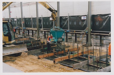
Photograph - Set of 2 prints of track construction inside Southbank Depot shed, c1996
... ...elevated track...Photographs show the construction of the concrete flooring and pillars that will hold the elevated stabling track inside the new Southbank Depot shed. ...Yields information about the construction of Southbank Depot trams stabling track elevated track Southbank Depot Colour prints with no notes. ...Photographs show the construction of the concrete flooring and pillars that will hold the elevated stabling track inside the new Southbank Depot shed. Yields information about the construction of Southbank Depot Colour prints with no notes.trams, stabling track, elevated track, southbank, depot -
 Halls Gap & Grampians Historical Society
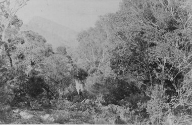
Photograph - Sepia
... Photo shows a person standing on elevated and rocky track beside a waterfall. There is an escarpment in the background...SCENERY Grampians Ranges Photo shows a person standing on elevated and rocky track beside a waterfall. There is an escarpment in the background Photograph Sepia ...Location of photo unknown.Photo shows a person standing on elevated and rocky track beside a waterfall. There is an escarpment in the backgroundscenery, grampians ranges -
 Warrnambool and District Historical Society Inc.
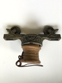
Equipment - Artefact, Lamson's Rapid Wire Cash Carrier, Youngers, C Early 20th century
... The first attempt to improve this was the ball system where a ball containing the cash was rolled to the cashier on an elevated track. The rapid wire system superseded this in the early 1900's and for the next 50 years it became a popular part of money handling in stores around Australia. ...The first attempt to improve this was the ball system where a ball containing the cash was rolled to the cashier on an elevated track. The rapid wire system superseded this in the early 1900's and for the next 50 years it became a popular part of money handling in stores around Australia. ...Lamson was established in Australia in 1898 with the idea for a store security money handling system being patented in the latter part of the 19th century.The practise of taking money from the counter and customer to the cashier was time consuming and cumbersome.Some bright ideas were employed including tying the money and dockets in a hankerchief and throwing it to the cashier. The first attempt to improve this was the ball system where a ball containing the cash was rolled to the cashier on an elevated track. The rapid wire system superseded this in the early 1900's and for the next 50 years it became a popular part of money handling in stores around Australia. This particular Lamson's cash carrier was installed in Youngers department store which was situated in Liebig Street. The success of Youngers store was partly responsible for the shift to Liebig St as the main commercial district. The Warrnambool Standard reported in 1901 that Younger and Co would operate on a wholly cash basis replacing incidental trades of goods such as potatoes and other farm produce.This item has strong social and historical significance. Apart from having strong links to one of Warrnambool's largest and longest running businesses, the object itself is of considerable interest with thousands of the original ball systems and Rapid Wire cash carriers being in use around the world. Cylindrical brass top with central circular part with section either side which have two small pulleys. A wooden cylindrical section slots in below with a wire clip attached at the bottom.Lamson is cast into the brass on either side of therim of the top circular section. . AUS is on the side of this same section. warrnambool,, youngers, youngers warrnambool, lamson, lamson rapid wire cash carrier, wire cash carrier -
 Alexandra Timber Tramway & Museum
Mr Sapsford, rubicon channel and tram tracks
... rubicon photo of channel and tram tracks, put in to feed hydro system .note tree harvest and elevated channel to the right taken by mr sapsford of alexandra...Alexandra Timber Tramway & Museum 17 Station Street Alexandra high-country Photograph of local event .Building of Rubicon power house ( station ) Detail of construction evedent in photo Un replaceable .record of local events rubicon channel and tram tracks rubicon photo of channel and tram tracks, put in to feed hydro system .note tree harvest and elevated channel to the right taken by mr sapsford of alexandra rubicon channel and tram tracks Mr Sapsford ...Photograph of local event .Building of Rubicon power house ( station ) Detail of construction evedent in photoUn replaceable .record of local eventsrubicon photo of channel and tram tracks, put in to feed hydro system .note tree harvest and elevated channel to the right taken by mr sapsford of alexandrarubicon channel and tram tracks -
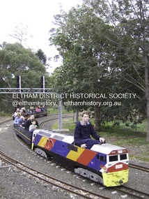 Eltham District Historical Society Inc
Photograph - Digital Photograph, Marguerite Marshall, Diamond Valley Railway, Eltham Lower Park, 7 September 2008
... The train clatters along the track and crosses a bridge over a drain elevated by name to The Blow Fly Creek. ...The train clatters along the track and crosses a bridge over a drain elevated by name to The Blow Fly Creek. ...Kids of all ages enjoy the Miniature Railway. Published: Nillumbik Now and Then / Marguerite Marshall 2008; photographs Alan King with Marguerite Marshall.; p163 On Sundays in Eltham thousands of children, mums, dads and grandparents can be seen travelling around Lower Eltham Park in tiny trains. They are among the two and half million passengers who have travelled on the Diamond Valley Railway since it officially began in 1961. The miniature railway originally operated from the 1940s at Chelsworth Park, Ivanhoe, until flooding caused it to be moved to the Eltham Lower Park in 1959. The railway is modelled on the 1920s era – the heyday of passenger rail travel – and the trains are built on a scale of two inches to the foot (1/6). Although not exact replicas, trains include models of the Spirit of Progress, Puffing Billy, The Overland, Dog Boxes, Vic Rail S class, G class and a NSW 81 Class. The three and a half kilometres of track is set amongst native plants and picnic areas. A friendly hoot or the clang of a bell occasionally punctuates the tranquillity as a train emerges from a treed bend with passengers excitedly waving to onlookers. For $3 the train takes you on a 13-minute two-kilometre ride. Passengers sit in single file in the narrow train, which clatters along tracks built to the scale of the Australian narrow gauge of three feet six inches (1.1m). These are used in Queensland, South Australia, Tasmania and Western Australia. Safety standards are stringently kept. Even before you buy a ticket notices tell you that you must wear closed shoes. You can even borrow these, and you are given a pair of socks for the ride! Blue-overalled volunteers check tickets, see you aboard, and drive the train. They are mainly retired men who can at last devote their time to what little boys dream of – playing with trains. Passengers are instructed in safe behaviour, then the station master waves a white flag and off we go. The guard sits at the back with his whistle and green flag at the ready. The winding track, fringed by native trees and bushes planted by volunteers, stands on crown land managed by Nillumbik Council. The train clatters along the track and crosses a bridge over a drain elevated by name to The Blow Fly Creek. We pass by Meadmore Junction at a speed of three kilometres an hour. Then on through a tunnel, accompanied by squeals of delight, and after a few moments of blackness, light glimmers at the end. On we go, past the original platform, along another route past busy Main Road through Pine Creek Station, over a bridge and through another tunnel with more screams of delight.Then a signal stops us before the ‘all clear’ to return to our original point of departure. The railway services its passengers – the largest number of any miniature railway in Australia – with a fleet including: six diesel locomotives, three steam locomotives, eight sets of passenger cars and one battery electric Dog Box set. Members also privately own 20 locomotives and powered carriage sets as well as four carriage sets.1 All the trains are stored on-site in workshops, sheds and a tunnel. The railway is entirely run by volunteers, so that all ticket money is used for maintenance and extensions, and some goes to local charities. Since 1991, the entire railway has been rebuilt, including an upgraded signalling system. About half of the 120 volunteer members are active with about 35 working each Sunday, and a dozen or so working every Wednesday. Members are trained to positions of station assistant, booking officer, train guard, train driver or signalman. Members construct new carriages and locomotives as well as maintaining track, signalling and rolling stock.This collection of almost 130 photos about places and people within the Shire of Nillumbik, an urban and rural municipality in Melbourne's north, contributes to an understanding of the history of the Shire. Published in 2008 immediately prior to the Black Saturday bushfires of February 7, 2009, it documents sites that were impacted, and in some cases destroyed by the fires. It includes photographs taken especially for the publication, creating a unique time capsule representing the Shire in the early 21st century. It remains the most recent comprehenesive publication devoted to the Shire's history connecting local residents to the past. nillumbik now and then (marshall-king) collection, diamond valley railway, eltham lower park -
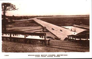 Bendigo Historical Society Inc.
Postcard - BASIL WATSON COLLECTION: BROOKLANDS MOTOR COURSE, WEYBRIDGE, VIEW FROM GRANDSTAND
... Photo taken from rear of elevated seating, situated to view the track....Photo taken from rear of elevated seating, situated to view the track. Postcard BASIL WATSON COLLECTION: BROOKLANDS MOTOR COURSE, WEYBRIDGE, VIEW FROM GRANDSTAND ...black and white postcard. On bottom of card: 'Brooklands Motor Course, Weybridge, view from grandstand' 13855. Photo taken from rear of elevated seating, situated to view the track.Kingsway Real Photo Seriesevent, sports, brooklands motor course, weybridge, uk -
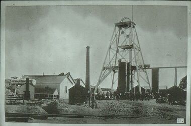 Bendigo Historical Society Inc.
Slide - ALBERT RICHARDSON COLLECTION: NEW ARGUS GOLD MINE, EAGLEHAWK
... Poppet head with elevated tramway, with ore cart on tracks. Engine room and boiler on LH side, brick chimney at rear. ...Poppet head with elevated tramway, with ore cart on tracks. Engine room and boiler on LH side, brick chimney at rear. ...Slide. New Argus Gold Mine, Eaglehawk, west of Sailor's Gully Road. Image taken about 1906. Poppet head with elevated tramway, with ore cart on tracks. Engine room and boiler on LH side, brick chimney at rear. Large group of men standing at base of poppet head.No. 23 on bottom of slide.mine, gold, new argus., bendigo mines-jack hattam collection -
Glenelg Shire Council Cultural Collection
Print - Lithograph, Early View of Town of Portland, 1890-1905
... elevated position. Cliffs on foreground right curve towards a series of piers. To right is a church and a series of houses on blocks, with a wide street in front. Couta boats, row boats and steam ships are in the harbour, one steamship is berthed at the end of a long pier with a railway track leading from it. ...elevated position. Cliffs on foreground right curve towards a series of piers. To right is a church and a series of houses on blocks, with a wide street in front. Couta boats, row boats and steam ships are in the harbour, one steamship is berthed at the end of a long pier with a railway track leading from it. ...Displayed in History House. Removed from frame and rehoused, January 2007. Previously owned by Murray Wilson, 1923-1989.Donated by Mrs Betty Wilson in memory of her husband, Murray Wilson (1923 - 1989)Lithograph of a drawing of Portland, viewed from an elevated position. Cliffs on foreground right curve towards a series of piers. To right is a church and a series of houses on blocks, with a wide street in front. Couta boats, row boats and steam ships are in the harbour, one steamship is berthed at the end of a long pier with a railway track leading from it. In background the coastline curves around the harbour, with a lighthouse evident on a bluff at upper left of image.Front: (no inscriptions) Back: Murray F. Wilson/from E. Wilson (on backing board, now removed) -
 Kew Historical Society Inc
Photograph - Railway level crossing in Glenferrie Road, Glenferrie, E.J. Dower, c.1912
... elevated on a bridge over Glenferrie Road. "The Don Store" at right is immediately behind the old railway level crossing. The tree and shops at left before the crossing were to be removed / demolished as part of the realignment of the train tracks....elevated on a bridge over Glenferrie Road. "The Don Store" at right is immediately behind the old railway level crossing. The tree and shops at left before the crossing were to be removed / demolished as part of the realignment of the train tracks. ...One of a series of photographs, taken by Edgar James Dower in the second decade of the twentieth century. Born and raised in Olinda, his family later moved to Surrey Hills. He worked as an adult as a clerk in the city office of the Metropolitan Gas Company, and in his role as a 'collector', he was able to photograph scenes including the construction of tramlines and associated buildings in Kew, Hawthorn, Camberwell and Surrey Hills. Later he established a real estate agency with his brother - the E.J. Dower Real Estate Agency, Dandenong Office.The image is an historically significant record of the development of transport infrastructure which was used to connect Victorians in the first two decades of the twentieth century. This development resulted from increases in population and the consequent extension of Melbourne's suburbs. The photographs, both individually and collectively, richly detail the labour of workers and the tools and machinery used to create and extend Melbourne's public transport network in the years preceding and during World War 1.Digital copy of an original mounted photograph showing Glenferrie Road Hawthorn, looking north towards the old railway level crossing that existed before the line was elevated on a bridge over Glenferrie Road. "The Don Store" at right is immediately behind the old railway level crossing. The tree and shops at left before the crossing were to be removed / demolished as part of the realignment of the train tracks.Annotated verso: "1914 [deleted]/1913 / Glenferrie Road showing railway gates / Taken just before the commencement of the regrading of railway line to Camberwell".theme --- travelling by tram, theme -- connecting victorians by transport and communications, glenferrie road -- hawthorn (vic.), railways -- hawthorn, the don store -- hawthorn (vic.) -
 Kew Historical Society Inc
Photograph - Railway level crossing in Glenferrie Road, Glenferrie, E.J. Dower, 1912
... elevated on a bridge over Glenferrie Road. "The Don Store" at right is immediately behind the old railway level crossing. The tree and shops at left before the crossing were to be removed / demolished as part of the realignment of the train tracks....elevated on a bridge over Glenferrie Road. "The Don Store" at right is immediately behind the old railway level crossing. The tree and shops at left before the crossing were to be removed / demolished as part of the realignment of the train tracks. ...One of a series of photographs, taken by Edgar James Dower in the second decade of the twentieth century. Born and raised in Olinda, his family later moved to Surrey Hills. He worked as an adult as a clerk in the city office of the Metropolitan Gas Company, and in his role as a 'collector', he was able to photograph scenes including the construction of tramlines and associated buildings in Kew, Hawthorn, Camberwell and Surrey Hills. Later he established a real estate agency with his brother - the E.J. Dower Real Estate Agency, Dandenong Office.The image is an historically significant record of the development of transport infrastructure which was used to connect Victorians in the first two decades of the twentieth century. This development resulted from increases in population and the consequent extension of Melbourne's suburbs. The photographs, both individually and collectively, richly detail the labour of workers and the tools and machinery used to create and extend Melbourne's public transport network in the years preceding and during World War 1.Digital copy of an original mounted photograph showing Glenferrie Road Hawthorn, looking north towards the old railway level crossing that existed before the line was elevated on a bridge over Glenferrie Road. "The Don Store" at right is immediately behind the old railway level crossing. The tree and shops at left before the crossing were to be removed / demolished as part of the realignment of the train tracks.Annotated verso: "Glenferrie Road, Glenferrie, showing railway gates and Walker's Store / Taken prior to the construction of electric tramline and the regrading of Camberwell Railway Line / Taken by E.J. Dower about 1912".theme --- travelling by tram, theme -- connecting victorians by transport and communications, glenferrie road -- hawthorn (vic.), railways -- hawthorn, the don store -- hawthorn (vic.) -
 Emerald Museum & Nobelius Heritage Park
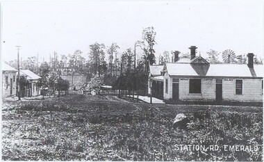
Photograph, Station Rd, Emerald, c. 1907
... tracks are not visible. While the annotation lists that the photograph was taken in 1889, the visibility of a gate (contra the annotation) and existence of this second town centre - which grew around the station - suggests that other sources lisitng 1907 are closer to accuracy. Note the posts in front of the Palace - used to tie horses in this time before cars became dominant. There are elevated...tracks are not visible. While the annotation lists that the photograph was taken in 1889, the visibility of a gate (contra the annotation) and existence of this second town centre - which grew around the station - suggests that other sources lisitng 1907 are closer to accuracy. Note the posts in front of the Palace - used to tie horses in this time before cars became dominant. There are elevated ...There are seven other copies of this photograph in our collection, mostly differing in the placement of the label and the cropping of the photograph. This is itself a copy of the original. One of these copies is also accessioned as VEMUP0456.2. This c. 1907 photograph was taken from the intersection of Beaconsfield Road (now Kilvington Drive) and Station Road (now Puffing Billy Place), looking towards Emerald Railway Station. It looks past the Emerald Coffee Palace, a significant establishment serving coffee, wine, and more - a room in the back was even used as a visiting doctor's surgery. The Coffee Palace was, at the time, owned by the O'Connor family and run by Mrs Greatorex. At this time it was relatively new - the second centre of Emerald, around Kilvington Drive, mostly materialised thanks to the location of the railway station. The location of the railway is visible, but from this angle the station and tracks are not visible. While the annotation lists that the photograph was taken in 1889, the visibility of a gate (contra the annotation) and existence of this second town centre - which grew around the station - suggests that other sources lisitng 1907 are closer to accuracy. Note the posts in front of the Palace - used to tie horses in this time before cars became dominant. There are elevated wires visible running along the left side of the street, which resemble power lines but at this time are more likely to have instead been telegraph cables.This photograph recounts the growth of Emerald's second town centre around the railway station.This item is a black and white copy of an older photograph. It depicts an unpaved street leading down a hill to a gate and fence, with several shops to either side. There is a lamp post on the street corner on the right, and a telegraph line running along the left side. In the background, the slope rises back up to a hill with fields and scattered trees.Bottom-right: "STATION RD. EMERALD" Building in the photograph: "EMERALD COFFEE PALACE" Reverse: "Coffee Palace was guest house / Note no gates this was before the railway Puffing Billy came through. / Note posts to tie horses to outside the palace. / O'Connors owned Coffee Palace. / Windmill in back of Palace - bore for water. 1889."emerald coffee palace, emerald, commerce, 1900s -
 Emerald Museum & Nobelius Heritage Park
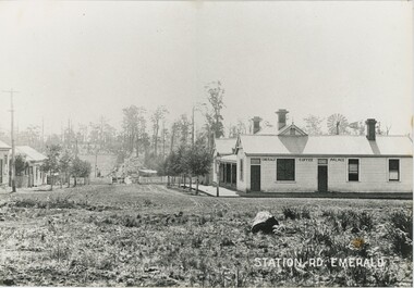
Photograph, Station Rd, Emerald, c. 1907
... tracks are not visible. Note the posts in front of the Palace - used to tie horses in this time before cars became dominant. There are elevated...tracks are not visible. Note the posts in front of the Palace - used to tie horses in this time before cars became dominant. There are elevated ...There are seven other copies of this photograph in our collection, mostly differing in the placement of the label and the cropping of the photograph. This is itself a copy of the original. One of these copies is also accessioned as VEMUP0456.2. This c. 1907 photograph was taken from the intersection of Beaconsfield Road (now Kilvington Drive) and Station Road (now Puffing Billy Place), looking towards Emerald Railway Station. It looks past the Emerald Coffee Palace, a significant establishment serving coffee, wine, and more - a room in the back was even used as a visiting doctor's surgery. The Coffee Palace was, at the time, owned by the O'Connor family and run by Mrs Greatorex. At this time it was relatively new - the second centre of Emerald, around Kilvington Drive, mostly materialised thanks to the location of the railway station. The location of the railway is visible, but from this angle the station and tracks are not visible. Note the posts in front of the Palace - used to tie horses in this time before cars became dominant. There are elevated wires visible running along the left side of the street, which resemble power lines but at this time are more likely to have instead been telegraph cables. This copy was framed in the donor's home after being gifted to him by its previous owner, who bought it from an op-shop in Melbourne.This photograph recounts the growth of Emerald's second town centre around the railway station.This item is a large, slightly yellowed, black and white copy of an older photograph. It depicts an unpaved street leading down a hill to a gate and fence, with several shops to either side. There is a lamp post on the street corner on the right, and a telegraph line running along the left side. In the background, the slope rises back up to a hill with fields and scattered trees.Bottom-right: "STATION RD. EMERALD" Building in the photograph: "EMERALD COFFEE PALACE"emerald coffee palace, emerald, 1900s, commerce