Showing 70 items matching "elgar's surrey"
-
 Surrey Hills Historical Society Collection
Book, Early Canterbury, 1994
... ...elgar's surrey...Surrey Hills Historical Society Collection 190A Canterbury Road Canterbury melbourne This booklet gives a brief description of the local settlement in Canterbury giving the landholders names and name of the house (before street numbering was introduced) and street it was located in. canterbury (ms) jane f portingale postmistress (mr) arundel wrighte wood brothers koonung creek (mr) thomas power (mr) oliver russell (mr) frederick griffin (mr) thomas payne shrublands w creek (mr) john gardiner (mr) james shanley (mr)robert hoddle (mr) michael logan (mr) patrick moloney (mr) hugh glass r. larkins t. hassett e. sturt d.s. campbell (mr) joseph camm riversdale road w. logan rochester road 1843 trees mont albert road a. sikes (mr) william smith 1853 (mr) ernest carter dentist elgar's surrey hindson family (mr) george granville mercy (mr) alfred golding (mr)alexander patterson (mr) thomas boanas (mr) thomas hyde builders (mr) richard terrill architects (mr) thomas miles drapers This booklet gives a brief description of the local settlement in Canterbury giving the landholders names and name of the house (before street numbering was introduced) and street it was located in. ...This booklet gives a brief description of the local settlement in Canterbury giving the landholders names and name of the house (before street numbering was introduced) and street it was located in.This booklet gives a brief description of the local settlement in Canterbury giving the landholders names and name of the house (before street numbering was introduced) and street it was located in.canterbury, (ms) jane f portingale, postmistress, (mr) arundel wrighte, wood brothers, koonung creek, (mr) thomas power, (mr) oliver russell, (mr) frederick griffin, (mr) thomas payne, shrublands, w creek, (mr) john gardiner, (mr) james shanley, (mr)robert hoddle, (mr) michael logan, (mr) patrick moloney, (mr) hugh glass, r. larkins, t. hassett, e. sturt, d.s. campbell, (mr) joseph camm, riversdale road, w. logan, rochester road, 1843, trees, mont albert road, a. sikes, (mr) william smith, 1853, (mr) ernest carter, dentist, elgar's surrey, hindson family, (mr) george granville mercy, (mr) alfred golding, (mr)alexander patterson, (mr) thomas boanas, (mr) thomas hyde, builders, (mr) richard terrill, architects, (mr) thomas miles, drapers -
 Surrey Hills Historical Society Collection
Work on paper - Vertical file on Back Creek, Surrey Hills
... It rises as a spring on the slopes of the hill at the corner of Canterbury Road and Elgar Road in Surrey Hills, the location of a Melbourne Water tower and reservoir. ...Surrey Hills Historical Society Collection 190A Canterbury Road Canterbury melbourne Back Creek is one of the tributaries of Gardiners Creek. It rises as a spring on the slopes of the hill at the corner of Canterbury Road and Elgar Road in Surrey Hills, the location of a Melbourne Water tower and reservoir. ...Back Creek is one of the tributaries of Gardiners Creek. It rises as a spring on the slopes of the hill at the corner of Canterbury Road and Elgar Road in Surrey Hills, the location of a Melbourne Water tower and reservoir. It has been channelled underground from this point in pipes as far as Union Road. South Surrey Park runs along both sides of Back Creek from where the creek crosses Union Rd near Rose Avenue to where it crosses Riversdale Road just west of Through Road. A vertical file containing information about Back Creek in Surrey Hills: 1. 4 colour photos taken in 1983 (1 page). 2. ‘Pipe dreams run their course’, (Boroondara Review ?) 17.4.2013 (1 page). 3. ‘Plan rainchecked for creek impact’, Boroondara Review, 13.3.2013 (2 pages). back creek -
 Surrey Hills Historical Society Collection
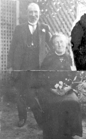
Photograph, Mr and Mrs William Tacey
... The first directory entries are in 1888 & 1889 for the Surrey Hills shop & Elgar Road. In Surrey Hills a substantial property was developed on land which "was purchased by Edward Tacey on 16 September 1889. ...The first directory entries are in 1888 & 1889 for the Surrey Hills shop & Elgar Road. In Surrey Hills a substantial property was developed on land which "was purchased by Edward Tacey on 16 September 1889. ...William (1857 - 1920) was a butcher. William was born 7 Nov 1857 on the Buckland (River) near Bright, son of John Joseph Tacey and wife Elizabeth Cooper. This was just a few months after the Buckland River anti-Chinese riots. He had siblings Thomas (1856-1929), Mary Ann (1860-1920), Edward (1863-1952) and Arthur Edward (1870-1896). William died 30 March 1920, Camberwell. He married Florence Margaret Edwards in 1884. Both are buried in Box Hill Cemetery (CE-0162). They had 7 surviving children; 2 died in infancy. William was a butcher in Thornbury but moved to Camberwell with his brothers seeing the opportunity in the new suburbs. They set up shops in Canterbury Road, opposite Highfield Road, Surrey Hills; Burwood; corner of Elgar & Whitehorse Roads, opposite the Whitehorse Hotel and Canterbury Road, Surrey Hills just east of Surrey Hotel. The first directory entries are in 1888 & 1889 for the Surrey Hills shop & Elgar Road. In Surrey Hills a substantial property was developed on land which "was purchased by Edward Tacey on 16 September 1889. Edward Tacey was a butcher and the Sands & MacDougall street directory indicates that a butcher’s shop had been constructed on the site and was operating by 1890. It seems that the family lived for some time at a house located next door to the shop at 627 Canterbury Road (visible on the 1909 MMBW plan, but since demolished). On 15 June 1920 Edward Tacey transferred all three blocks of land to Joseph Tacey, most likely his son * and also a butcher, who carried on business from the same premises. Joseph Tacey died on 20 February 1933, after which administration of his estate (which included the three blocks of land) passed to his widow, Mary Dorothy Tacey." (Context P/L Heritage Assessment) Correction: *Edward Tacey (1863 - 1952) was the brother of William Tacey (1857 - 1920). The property passed to Joseph Charles Tacey (1887 - 1933), his nephew and son of William, not his son. His wife was Mary Dorothy Coates. Albert Arthur Tacey was a brother of Joseph Charles Tacey. Edward later moved from the area and continued in the business in a number of regional Victorian centres. In Surrey Hills the business was continued by other members of the family including Albert Arthur Tacey (1902-1959) who lived at 7 Sunbury Crescent, and daughter Stella Florence Tacey and her husband Roy Morris and their son Harry Tacey Morris. The donor of the Tacey collection of photos was Elaine Merle Tacey (1925-2003), daughter of Albert Arthur Tacey. She married Donald McKenzie. A black and white photograph of a couple in the garden. The man is standing and wearing a 3 piece suit whilst the lady is seated and holding a posy of flowers in her lap.(mr) william tacey, butchers, (mr) edward tacey, (mr) thomas tacey, (mr) joseph tacey, (mrs) stella morris, (mr) roy morris, (miss) florence margaret edwards, (mrs) florence margaret tacey, (mr) albert arthur tacey, (miss) stella tacey, (mr) harry tacey morris -
Box Hill Historical Society
Photograph - Aerial Photograph of Box Hill
... Aerial view of Box Hill looking east from Surrey Park at the corner of Canterbury Road and Elgar Road. Also shows construction of the new swimming pool complex....Box Hill Historical Society Box Hill Heritage Centre Suite 7 Town Hall Hub Box Hill melbourne Aerial view of Box Hill looking east from Surrey Park at the corner of Canterbury Road and Elgar Road. Also shows construction of the new swimming pool complex. ...Aerial view of Box Hill looking east from Surrey Park at the corner of Canterbury Road and Elgar Road. Also shows construction of the new swimming pool complex.B&w photoaerial photographs, canterbury road, surrey park, alexander street, swimming pools -
 Box Hill Historical Society
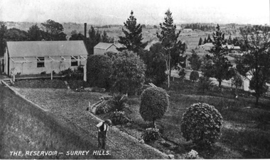
Photograph - Reservoirs
... Surrey Hills. It shows someone working in the garden in the foreground and a shed on the lefthand side of the picture. This could be either the reservoir in Canterbury Road or the one in Elgar Road....Surrey Hills. It shows someone working in the garden in the foreground and a shed on the lefthand side of the picture. This could be either the reservoir in Canterbury Road or the one in Elgar Road. ...The Reservoir in Surrey Hills. It shows someone working in the garden in the foreground and a shed on the lefthand side of the picture. This could be either the reservoir in Canterbury Road or the one in Elgar Road.B&w photosurrey hills, dams and reservoirs -
 Surrey Hills Historical Society Collection
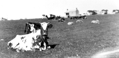
Photograph, Norman Carter, Part of Black's dairy farm in Mont Albert in the 1920s, 1920s
... Surrey Hills Historical Society Collection 190A Canterbury Road Canterbury melbourne Photo is likely to have been taken pre-1924 when the land was subdivided. Donor information is that this was taken from a home in Churchill Street, Mont Albert; it would be looking south towards Mont Albert Road. Black's dairy farm occupied the area just east of Hamilton Street to near Elgar ...Photo is likely to have been taken pre-1924 when the land was subdivided. Donor information is that this was taken from a home in Churchill Street, Mont Albert; it would be looking south towards Mont Albert Road. Black's dairy farm occupied the area just east of Hamilton Street to near Elgar Road. It was subdivided into 88 house allotments along Churchill Street, Bruce Street, Black Street, Proudfoot Street and View Street. The solicitors were Proudfoot & Horton, 360 Collins Street; estate agents were Duncan & Weller, 29 Queen Street. The real estate subdivision notice on the SLV website states that Neil Black had been the owner for 50 years. To date no trace of a Neil Black has been found. Box Hill rate books simply give BLACK as the owner in 1877 (no first name); the entry for 1878-1884 states Robert Black. The 1909 electoral roll has entries for Mont Albert Road for Robert Black (farmer), Thomas Black (carter) & Elizabeth Black (HD). The 1912 electoral roll has entries for Mont Albert Road for Robert Black (farmer), Thomas Black (labourer), John Arthur Black (carter) & Elizabeth Black (HD). Robert Black died in 1920 (b. 1836) and is buried in Box Hill Cemetery (CE-*-0057). His parents were John and Margaret Black. He married Lizzie Foley in 1878. She was the daughter of Margaret & John Foley, born in 1859. She died in 1902 aged 43 years and is probably buried in the same grave, although the cemetery records record her age as 0 years. Children: 1. James Hughbert (1880-1954) 2. John Arthur (1881-1959) 3. Alice (1882-1883) - died aged 6 months 4. Laura Elizabeth (1883-1951) 5. Thomas (1885-1965) 6. Isabella (1887-1963) 7. Eleanor (1889-1963) 8. Ada Maud (1890-1968) 9. Robert (1892-1930). BDM Victoria states places of birth as Box Hill, Surrey Hills or Mont Albert. Many of the family are buried in Box Hill Cemetery. None of the girls appear to have married. Communication from a descendant of John Arthur Black gives the following: "John Arthur Black, son of Robert & Lizzie Foley, married Gladys Anne Layton had 4 children, Robert, Elenore, Marion (Follett) & Annie; they had farm on Stud Road, Dandenong where they milked 30 cows that he retired to after being a earth-moving contractor with draft horses and dug irrigation ditches around Shepparton." This is important as documentation of the area's early farming land use.Black and white photo of a paddock with cows and sheep grazing. On the horizon is a simple cottage with a small veranda and 2 chimneys and scattered trees.black's dairy farm, dairying, farms, churchill street, black street, proudfoot street, bruce street, view street, neil black, proudfoot & horton, duncan & weller, robert black, lizzie black, lizzie foley, james hubert black, john arthur black, alice black, laura elizabeth black, thomas black, isabella black, eleanor black, ada maud black, robert black jnr, box hill cemetery -
 Surrey Hills Historical Society Collection
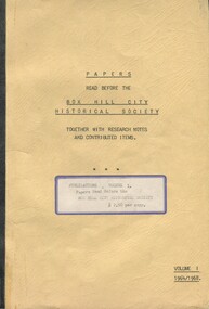
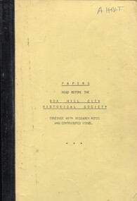
Book, Papers read before the Box Hill Historical Society: together with research notes and contributed items, Vol. I 1964-68, 1968
... Surrey Hills Historical Society Collection 190A Canterbury Road Canterbury melbourne A collection of papers presented at meetings of the Box Hill Historical Society detailing hsitory of local families, churches, schools and other significant histories. box hill elgar's special survey ballyshanassy aspinall family sutton family box hill cemetery 1964 1968 schools ormiston girls' school talbett family britnell family bedford family "F. ...A collection of papers presented at meetings of the Box Hill Historical Society detailing hsitory of local families, churches, schools and other significant histories.A collection of papers presented at meetings of the Box Hill Historical Society detailing history of local families, churches, schools and other significant histories."F. N. Bamford" on title pagebox hill, elgar's special survey, ballyshanassy, aspinall family, sutton family, box hill cemetery, 1964, 1968, schools, ormiston girls' school, talbett family, britnell family, bedford family -
 Surrey Hills Historical Society Collection
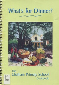
Book, What's for dinner? The Chatham Primary School Cook book, Nov 1999
... Surrey Hills. Silky Swallow was a Chinese restaurant at 369/371 Mont Albert Road, Mont Albert. Wild Flower was located at 1 Theatre Place, Canterbury. It was established in c1993 and until 2004 was BYO. Chef's Tandoor is located at It was established in 1991 by Mr Virender Bist (Owner/Chef) who had been head chef with the Taj Group of Hotels. Bollywood on the park is located at 156 Elgar...Surrey Hills. Silky Swallow was a Chinese restaurant at 369/371 Mont Albert Road, Mont Albert. Wild Flower was located at 1 Theatre Place, Canterbury. It was established in c1993 and until 2004 was BYO. Chef's Tandoor is located at It was established in 1991 by Mr Virender Bist (Owner/Chef) who had been head chef with the Taj Group of Hotels. Bollywood on the park is located at 156 Elgar ...The book was edited by Clare Nicholls (Coney) and the photo on the front cover shows a view of her then home 'Monserrat' at 26A Wandsworth Road, Surrey Hills. Silky Swallow was a Chinese restaurant at 369/371 Mont Albert Road, Mont Albert. Wild Flower was located at 1 Theatre Place, Canterbury. It was established in c1993 and until 2004 was BYO. Chef's Tandoor is located at It was established in 1991 by Mr Virender Bist (Owner/Chef) who had been head chef with the Taj Group of Hotels. Bollywood on the park is located at 156 Elgar Rd, Box Hill South, opposite Wattle Park. A community cook book with recipes for every occasion. It includes recipes contributed by staff and families plus special recipes from local restaurants and celebrities.chatham primary school, cook book, chef's tandoor, bollywood on the park, wildflower restaurant, silky swallow restaurant, monserrat -
 Surrey Hills Historical Society Collection
Book, Box Hill Historical Society, Papers read before the Box Hill Historical Society: together with research notes and contributed items, Vol. I 1964-68, 1968
... Surrey Hills Historical Society Collection 190A Canterbury Road Canterbury melbourne box hill elgar's special survey ballyshanassy aspinall family sutton family box hill cemetery 1964 1968 schools ormiston girls' school talbett family britnell family bedford family "F. ...A collection of papers presented at meetings of the Box Hill Historical Society detailing hsitory of local families, churches, schools and other significant histories."F. N. Bamford" on title pagebox hill, elgar's special survey, ballyshanassy, aspinall family, sutton family, box hill cemetery, 1964, 1968, schools, ormiston girls' school, talbett family, britnell family, bedford family -
 Surrey Hills Historical Society Collection
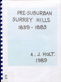
Book, Alan Judge Holt (deceased), Pre-Suburban Surrey Hills 1839-1883, 1989
... elgar road...view hill...new street...surry mont...delany's hill...reservoir hill...riversdale road...middlesex road...surrey...(mr) henry jamieson (mr) ken hall (ms) edna holt (mr) frank bamford (mr) harrison buchanan scouts grange hill wattle park round hill bona vista mount albert barton street (mr) john raeburn (mr) edmund holt (mr) james dunn butter merchant mont albert road elgar road view hill new street surry mont delany's hill reservoir hill riversdale road middlesex road surrey hills (mr) aldo massora aborigines damper creek back creek west creek kooyongkoot creek (mr) john gardiner (mr) chas mullins (mr) henry elgar (mr) robert campbell (mr) alexander dyce (mr) robert brooks t budds payne (mr) hugh glass (mr) patrick trainer w virtue (mr) t fulton (mr) john crimp (mr) w dempsey (mr) w e stanbridge (mr) james atkinson j porter j collings w edde (mr) orlando fenwick (dr)(mr) l l smith (mr) j h knipe (mr) george cockcroft (sr) (mr) john martin kleinert w morton d delaney a moeller (mr) william smith (mr) e.p.s.sturt (mr) thomas blood (mr) patrick mornane (mr) henry de carle w craig j hill w oliver j keogh a laing vineyards toll gates (mr) david staig (mr) phillip kleeper (mr) goyder usher (mr) james lawler (mr) w.e. stanbridge (mr) gideon rutherford c a f mater j gadsby w h wrixon e h lamont i ainger (mr) james henty (mr) henry henty w freemantle w palmer beckett park, maranoa gardens Unpublished manuscript / notes written by Alan Holt about settlers in and around Surrey Hills bound in-house. ...Author: Alan Judge Holt amassed a significant collection of historical material related to the Surrey Hills area. Born in Moonee Ponds in 1912 to Edmund Holt and Ellen Ruby Sutton, he married Edna Jean Pallot in 1937. They lived at 62 Broughton Road, Surrey hills, had 3 sons and were strongly associated with the Surrey Hills Methodist Church. Alan was Secretary of the Victorian Lands Department and in his spare time recorded the occupancy of every property in Surrey Hills and Mont Albert at the beginning of each decade from 1890 to 1980. His collection of files and individual cards covers people, places, churches, clubs, businesses and other organisations in the area. Alan used this information to give talks and tours of the area and gifted his material to the local history collection through Jocelyn Hall.Unpublished manuscript / notes written by Alan Holt about settlers in and around Surrey Hills bound in-house. It is supported by maps showing landowners over various years from about 1840-1885(mr) henry jamieson, (mr) ken hall, (ms) edna holt, (mr) frank bamford, (mr) harrison buchanan, scouts, grange hill, wattle park, round hill, bona vista, mount albert, barton street, (mr) john raeburn, (mr) edmund holt, (mr) james dunn, butter merchant, mont albert road, elgar road, view hill, new street, surry mont, delany's hill, reservoir hill, riversdale road, middlesex road, surrey hills, (mr) aldo massora, aborigines, damper creek, back creek, west creek, kooyongkoot creek, (mr) john gardiner, (mr) chas mullins, (mr) henry elgar, (mr) robert campbell, (mr) alexander dyce, (mr) robert brooks, t budds payne, (mr) hugh glass, (mr) patrick trainer, w virtue, (mr) t fulton, (mr) john crimp, (mr) w dempsey, (mr) w e stanbridge, (mr) james atkinson, j porter, j collings, w edde, (mr) orlando fenwick, (dr)(mr) l l smith, (mr) j h knipe, (mr) george cockcroft, (sr) (mr) john martin kleinert, w morton, d delaney, a moeller, (mr) william smith, (mr) e.p.s.sturt, (mr) thomas blood, (mr) patrick mornane, (mr) henry de carle, w craig, j hill, w oliver, j keogh, a laing, vineyards, toll gates, (mr) david staig, (mr) phillip kleeper, (mr) goyder usher, (mr) james lawler, (mr) w.e. stanbridge, (mr) gideon rutherford, c a f mater, j gadsby, w h wrixon, e h lamont, i ainger, (mr) james henty, (mr) henry henty, w freemantle, w palmer, beckett park, maranoa gardens -
 Surrey Hills Historical Society Collection
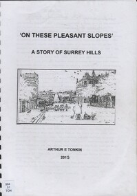
Book, On these pleasant slope's: a story of Surrey Hills, 2015
... Surrey Hills History. Including Alan Holt, Jack McLean, Frank Bamford, Jocelyn Hall. Includes: Topographical maps, first Elgar Survey. ...Surrey Hills History. Including Alan Holt, Jack McLean, Frank Bamford, Jocelyn Hall. Includes: Topographical maps, first Elgar Survey. ...Sourced via conversations with those interested in Surrey Hills History. Including Alan Holt, Jack McLean, Frank Bamford, Jocelyn Hall. Includes: Topographical maps, first Elgar Survey. First Wesleyan Church in Surrey Hills. Bibliography on P.50 (last numbered page) Provides a chronological history of Surrey Hills. Includes: First settlers, location, early land sales, commerce and trade.Provides a chronological history of Surrey Hills. Includes: First settlers, location, early land sales, commerce and trade.Back of Title page: To the Surrey Hills Historical / Arthur E. Tonkinfreehold investment and banking company, windsor park estate, (mr) dennis delany, mont albert village, surrey hills - history, royal hotel, surrey hills, humberstone's hotel, chatham state school, holy trinity church, lydswood, lugano, (mr) john butler maling, (mr) john hanlon knipe, mont albert primary school, (mr) james sneddon, (mr) arthur tonkin -
 Surrey Hills Historical Society Collection
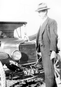
Photograph, Mr James de Graaf, 1929
... Surrey Hills Historical Society Collection 190A Canterbury Road Canterbury melbourne Mr James de Graaf in 1929 with his 1925 T FORD. James’ father Jacobus de Graaf arrived in Melbourne from Holland in 1853 and married Eliza Twite, aged 16 years. James married Caroline Kink in 1885 and came to live at 13 Charles Street, near Elgar ...Mr James de Graaf in 1929 with his 1925 T FORD. James’ father Jacobus de Graaf arrived in Melbourne from Holland in 1853 and married Eliza Twite, aged 16 years. James married Caroline Kink in 1885 and came to live at 13 Charles Street, near Elgar Road soon after. James rode to and from work in Richmond until the train timetables were suitable for his work schedule. He then would put his bicycle in the guards van and from Richmond would still have to ride a distance. Eventually he worked in the timber trade in Box Hill. One of his recreations was the training of gun-dogs and he also boarded gun-dogs for some local owners. A black and white photograph of a man standing in front of a Ford motor car. He is wearing a 3 piece suit and and a hat. The registration no. of the car is 9743.(mr) james de graaf, motor vehicles, (mr) jacobus de graaf, (miss) eliza twite, (miss) caroline kink, model t ford, charles street, mont albert, surrey hills, dogs -
 Surrey Hills Historical Society Collection
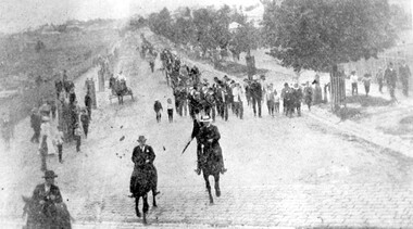
Photograph, Parade in celebration of King Edward VII's birthday, 1902, 1902
... Surrey Family Hotel. Band master is Harry Pollard, painter and paper-hanger, and next to him is Constable Hill. The small boy in the sailor suit is Perc Venman of Essex Road and in the buggy near the footpath is Mr and Mrs William Maling. Information came from David Staig senior. Further research: William Saunders Maling, a son of John Butler Maling, was a builder who lived at 17 Balwyn Road, Canterbury. Rowland Coe, a butcher and son of James and Elizabeth Coe of Sunbury Crescent enlisted in AIF in WW1. He later lived at 233 Elgar...Surrey Family Hotel. Band master is Harry Pollard, painter and paper-hanger, and next to him is Constable Hill. The small boy in the sailor suit is Perc Venman of Essex Road and in the buggy near the footpath is Mr and Mrs William Maling. Information came from David Staig senior. Further research: William Saunders Maling, a son of John Butler Maling, was a builder who lived at 17 Balwyn Road, Canterbury. Rowland Coe, a butcher and son of James and Elizabeth Coe of Sunbury Crescent enlisted in AIF in WW1. He later lived at 233 Elgar ...The parade was held in celebration of King Edward VII's birthday on 4 July 1902. This was the first public appearance of the German Band formed on 30 May 1902. The leading horseman is Mr Rowland Coe. He is followed by Mr George Robinson, a butcher of Canterbury Road. The man in the white hat is Mr Sam Kellett, businessman of Erasmus Street. Behind him on foot and partly obscured is Mr Alexander McNeill of the Surrey Family Hotel. Band master is Harry Pollard, painter and paper-hanger, and next to him is Constable Hill. The small boy in the sailor suit is Perc Venman of Essex Road and in the buggy near the footpath is Mr and Mrs William Maling. Information came from David Staig senior. Further research: William Saunders Maling, a son of John Butler Maling, was a builder who lived at 17 Balwyn Road, Canterbury. Rowland Coe, a butcher and son of James and Elizabeth Coe of Sunbury Crescent enlisted in AIF in WW1. He later lived at 233 Elgar Road, Box Hill. William Percival Reginald (Perc) Venman was born in Surrey Hills in 1894; he died in Surrey Hills in 1951 and lived at 27 Essex Street for much of his life. He and his wife are buried in Box Hill Cemetery. The identity of Sam Kellett of Erasmus Street is questioned. Edward Kellett built 'Yielma' in Erasmus Street but was deceased by 1902. He had 3 sons: Edward Allan (1854-1932); George Henry (1858-1921) and William John (1865-1945).Black and white photo of a number of men on horses leading a parade down Station Street (Windsor Crescent) to Union Road. Street trees on the RHS are mature whilst the ones on the LHS look to be newly planted. They have wooden guards around them. The area to the left is blurry but would be the railway line and station surrounds. Roads are well formed with bluestone channels.parades and processions, bands, german band, windsor crescent, william saunders maling, mrs hannah maling, miss hannah miller, constable hill, perc venman, george robinson, sam kellett, alexander mcneill, rowland coe, harry pollard, william percival reginald venman -
 Surrey Hills Historical Society Collection
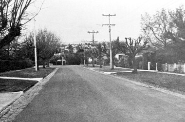
Photograph, Streetscape near the corner of Victoria Crescent and Hotham Street, Surrey Hills
... Surrey Hills Golf Club operated from 1892-1908 then moved and became Riversdale Golf Club. The game was played across paddocks from Trafalgar Street, Mont Albert to Whitehorse Road and down Victoria Crescent to where Box Hill TAFE is now located in Elgar Road. ...Surrey Hills Golf Club operated from 1892-1908 then moved and became Riversdale Golf Club. The game was played across paddocks from Trafalgar Street, Mont Albert to Whitehorse Road and down Victoria Crescent to where Box Hill TAFE is now located in Elgar Road. ...Prior to subdivision for housing this area was paddocks used for grazing of cattle and used as part of the course in the early days of the Surrey Hills Golf Club. Reproduced by permission of Mr John Arnold from his book: "The Riversdale Golf Club - a history, 1892-1977." Copyright to book: Riversdale Golf Club. Surrey Hills Golf Club operated from 1892-1908 then moved and became Riversdale Golf Club. The game was played across paddocks from Trafalgar Street, Mont Albert to Whitehorse Road and down Victoria Crescent to where Box Hill TAFE is now located in Elgar Road. There were problems with cows eating the tee flags! The clubhouse still exists as 30 Trafalgar Street.Black and white photo taken from the centre of a bitumen road which is flanked by bluestone guttering. Nature strips, drive cross-overs and house fences are shown. Trees on the RHS nature strip are pollarded to avoid overhead power and telephone lines. There houses in the background."Bottom: The same view today taken from the intersection of Victoria Crescent and Hotham Street, Surrey Hills."surrey hills golf club, hotham street, victoria crescent, riversdale golf club, surrey hills, john arnold -
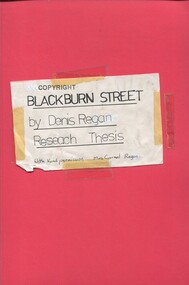 Surrey Hills Historical Society Collection
Book, Blackburn Street, ?1980s
... Includes some photos and house prices. surrey hills blackburn street (mr) denis regan blackburn estate elgar's special survey (mr) fred hemingway oldis houses californian bungalow (mr) william holland house names clevedon (mrs) christina holland (mrs) carmel regan (mr) len lewis (mrs) doreen lewis A thesis prepared by Mr Denis Regan for a Home and Environment Study, on Surrey Hills, Blackburn Street, and in particular no. 3 Blackburn Street, built in 1920. ...A thesis prepared by Mr Denis Regan for a Home and Environment Study, on Surrey Hills, Blackburn Street, and in particular no. 3 Blackburn Street, built in 1920. Includes some photos and house prices.A thesis prepared by Mr Denis Regan for a Home and Environment Study, on Surrey Hills, Blackburn Street, and in particular no. 3 Blackburn Street, built in 1920. Includes some photos and house prices.surrey hills, blackburn street, (mr) denis regan, blackburn estate, elgar's special survey, (mr) fred hemingway oldis, houses, californian bungalow, (mr) william holland, house names, clevedon, (mrs) christina holland, (mrs) carmel regan, (mr) len lewis, (mrs) doreen lewis -
Surrey Hills Historical Society Collection
Folder of real estate advertisements, Folders of real estate advertisements (Streets beginning with E), Various
... Surrey Hills Historical Society Collection 190A Canterbury Road Canterbury melbourne earle close edyvean street elgar road elm street empress road erasmus street essex road everton grove A4 folders with individual pockets for each property in streets beginning with E located in Surrey Hills and Mont Albert. ...A4 folders with individual pockets for each property in streets beginning with E located in Surrey Hills and Mont Albert. Folders are ordered by street name and then chronologically by property number. Each property has its own pocket. This may include multiple real estate advertisements collected from sales over time. It may also include copies of any research undertaken by Alan Holt and / or members of the SHNCHC team. These are augmented by cards in the Alan Holt index file and by his property registers of Surrey Hills and Mont Albert.earle close, edyvean street, elgar road, elm street, empress road, erasmus street, essex road, everton grove -
 Surrey Hills Historical Society Collection
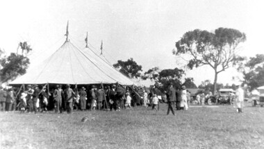
Photograph, Subdivision sale of Black's Mont Albert farm in 1924, 1924
... Surrey Hills Historical Society Collection 190A Canterbury Road Canterbury melbourne Photo was taken in 1924 when the land was subdivided. Black's dairy farm occupied the area just east of Hamilton Street to near Elgar Road. ...Photo was taken in 1924 when the land was subdivided. Black's dairy farm occupied the area just east of Hamilton Street to near Elgar Road. It was subdivided into 88 house allotments along Churchill Street, Bruce Street, Black Street, Proudfoot Street and View Street. The solicitors were Proudfoot & Horton, 360 Collins Street; estate agents were Duncan & Weller, 29 Queen Street. The real estate subdivision notice on the SLV website states that Neil Black had been the owner for 50 years. To date no trace of a Neil Black has been found. Box Hill rate books simply give BLACK as the owner in 1877 (no first name); the entry for 1878-1884 states Robert Black. The 1909 electoral roll has entries for Mont Albert Road for Robert Black (farmer), Thomas Black (carter) & Elizabeth Black (HD). The 1912 electoral roll has entries for Mont Albert Road for Robert Black (farmer), Thomas Black (labourer), John Arthur Black (carter) & Elizabeth Black (HD). Robert Black died in 1920 (b. 1836) and is buried in Box Hill Cemetery (CE-*-0057). His parents were John and Margaret Black. He married Lizzie Foley in 1878. She was the daughter of Margaret & John Foley, born in 1859. She died in 1902 aged 43 years and is buried in the same grave, although the cemetery records record her age as 0 years (presumably as no age or date of birth were given at the time of burial). Children: 1. James Hughbert (1880-1954) 2. John Arthur (1881-1959) 3. Alice (1882-1883) - died aged 6 months 4. Laura Elizabeth (1883-1951) 5. Thomas (1885-1965) 6. Isabella (1887-1963) 7. Eleanor (1889-1963) 8. Ada Maud (1890-1968) 9. Robert (1892-1930). BDM Victoria states places of birth as Box Hill, Surrey Hills or Mont Albert. Many of the family are buried in Box Hill Cemetery. None of the girls appear to have married. Communication from a descendant of John Arthur Black gives the following: "John Arthur Black, son of Robert & Lizzie Foley, married Gladys Anne Layton had 4 children, Robert, Elenore, Marion (Follett) & Annie; they had farm on Stud Road, Dandenong where they milked 30 cows that he retired to after being a earth-moving contractor with draft horses and dug irrigation ditches around Shepparton." This is important as documentation of the area's transformation from farming land to residential land use.Black and white photo of a large 3-poled tent in an area of flat land with eucalypts in the background. There is a large crowd of people, mainly men but also women and children. There are also 3 cars to the RHS.black's dairy farm, dairying, farms, churchill street, black street, proudfoot street, bruce street, view street, neil black, proudfoot & horton, duncan & weller, robert black, lizzie black, lizzie foley, james hubert black, john arthur black, alice black, laura elizabeth black, thomas black, isabella black, eleanor black, ada maud black, robert black jnr, box hill cemetery, land sales -
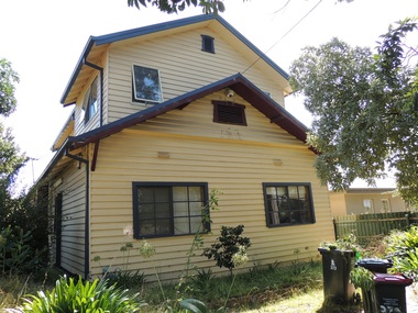
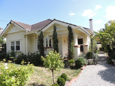
 Surrey Hills Historical Society Collection
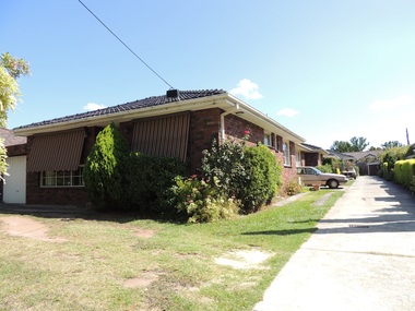
Photograph - 393 Elgar Road, Mont Albert, The Street Where You Live Project
... These photos provide a snapshot of real estate in the suburbs of Mont Albert and Surrey Hills during a period of rapid change with many properties on large blocks demolished to create higher density residential development or renewal of single dwellings. At particular risk were properties not covered by heritage overlays, in particular interwar housing and post 1950's housing. The Street Where You Live Project Photograph 393 Elgar ...Photos documenting this address as part of a photographic series undertaken by volunteer photographers during 2013 and 2014 for The Street Where You Live Project. This was organised through the Surrey Hills Neighbourhood Centre and covered the postcode 3127 in the cities of Boroondara and Whitehorse.These photos provide a snapshot of real estate in the suburbs of Mont Albert and Surrey Hills during a period of rapid change with many properties on large blocks demolished to create higher density residential development or renewal of single dwellings. At particular risk were properties not covered by heritage overlays, in particular interwar housing and post 1950's housing. -
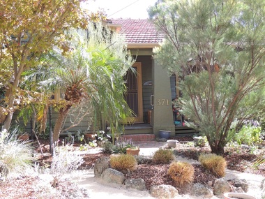
 Surrey Hills Historical Society Collection
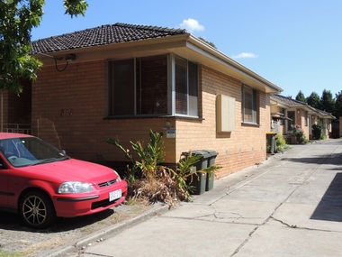
Photograph - 391 Elgar Road, Mont Albert, The Street Where You Live Project
... These photos provide a snapshot of real estate in the suburbs of Mont Albert and Surrey Hills during a period of rapid change with many properties on large blocks demolished to create higher density residential development or renewal of single dwellings. At particular risk were properties not covered by heritage overlays, in particular interwar housing and post 1950's housing. The Street Where You Live Project Photograph 391 Elgar ...Photos documenting this address as part of a photographic series undertaken by volunteer photographers during 2013 and 2014 for The Street Where You Live Project. This was organised through the Surrey Hills Neighbourhood Centre and covered the postcode 3127 in the cities of Boroondara and Whitehorse.These photos provide a snapshot of real estate in the suburbs of Mont Albert and Surrey Hills during a period of rapid change with many properties on large blocks demolished to create higher density residential development or renewal of single dwellings. At particular risk were properties not covered by heritage overlays, in particular interwar housing and post 1950's housing. -
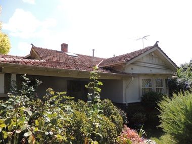
 Surrey Hills Historical Society Collection
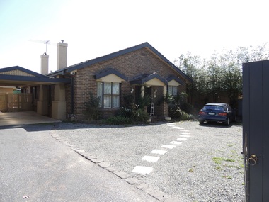
Photograph - 389 Elgar Road, Mont Albert, The Street Where You Live Project
... These photos provide a snapshot of real estate in the suburbs of Mont Albert and Surrey Hills during a period of rapid change with many properties on large blocks demolished to create higher density residential development or renewal of single dwellings. At particular risk were properties not covered by heritage overlays, in particular interwar housing and post 1950's housing. The Street Where You Live Project Photograph 389 Elgar ...Photos documenting this address as part of a photographic series undertaken by volunteer photographers during 2013 and 2014 for The Street Where You Live Project. This was organised through the Surrey Hills Neighbourhood Centre and covered the postcode 3127 in the cities of Boroondara and Whitehorse.These photos provide a snapshot of real estate in the suburbs of Mont Albert and Surrey Hills during a period of rapid change with many properties on large blocks demolished to create higher density residential development or renewal of single dwellings. At particular risk were properties not covered by heritage overlays, in particular interwar housing and post 1950's housing. -
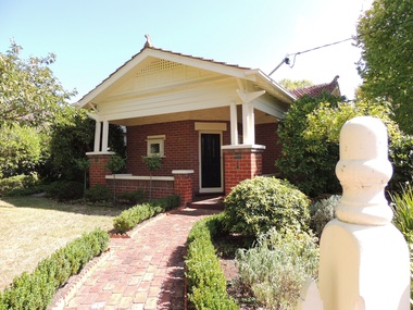
 Surrey Hills Historical Society Collection
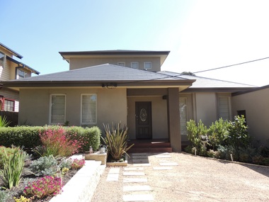
Photograph - 387 Elgar Road, Mont Albert, The Street Where You Live Project
... These photos provide a snapshot of real estate in the suburbs of Mont Albert and Surrey Hills during a period of rapid change with many properties on large blocks demolished to create higher density residential development or renewal of single dwellings. At particular risk were properties not covered by heritage overlays, in particular interwar housing and post 1950's housing. The Street Where You Live Project Photograph 387 Elgar ...Photos documenting this address as part of a photographic series undertaken by volunteer photographers during 2013 and 2014 for The Street Where You Live Project. This was organised through the Surrey Hills Neighbourhood Centre and covered the postcode 3127 in the cities of Boroondara and Whitehorse.These photos provide a snapshot of real estate in the suburbs of Mont Albert and Surrey Hills during a period of rapid change with many properties on large blocks demolished to create higher density residential development or renewal of single dwellings. At particular risk were properties not covered by heritage overlays, in particular interwar housing and post 1950's housing. -
 Surrey Hills Historical Society Collection
Photograph - 385 Elgar Road, Mont Albert, The Street Where You Live Project
... These photos provide a snapshot of real estate in the suburbs of Mont Albert and Surrey Hills during a period of rapid change with many properties on large blocks demolished to create higher density residential development or renewal of single dwellings. At particular risk were properties not covered by heritage overlays, in particular interwar housing and post 1950's housing. The Street Where You Live Project Photograph 385 Elgar ...Photos documenting this address as part of a photographic series undertaken by volunteer photographers during 2013 and 2014 for The Street Where You Live Project. This was organised through the Surrey Hills Neighbourhood Centre and covered the postcode 3127 in the cities of Boroondara and Whitehorse.These photos provide a snapshot of real estate in the suburbs of Mont Albert and Surrey Hills during a period of rapid change with many properties on large blocks demolished to create higher density residential development or renewal of single dwellings. At particular risk were properties not covered by heritage overlays, in particular interwar housing and post 1950's housing. -
 Surrey Hills Historical Society Collection
Photograph - 383 Elgar Road, Mont Albert, The Street Where You Live Project
... These photos provide a snapshot of real estate in the suburbs of Mont Albert and Surrey Hills during a period of rapid change with many properties on large blocks demolished to create higher density residential development or renewal of single dwellings. At particular risk were properties not covered by heritage overlays, in particular interwar housing and post 1950's housing. The Street Where You Live Project Photograph 383 Elgar ...Photos documenting this address as part of a photographic series undertaken by volunteer photographers during 2013 and 2014 for The Street Where You Live Project. This was organised through the Surrey Hills Neighbourhood Centre and covered the postcode 3127 in the cities of Boroondara and Whitehorse.These photos provide a snapshot of real estate in the suburbs of Mont Albert and Surrey Hills during a period of rapid change with many properties on large blocks demolished to create higher density residential development or renewal of single dwellings. At particular risk were properties not covered by heritage overlays, in particular interwar housing and post 1950's housing. -
 Surrey Hills Historical Society Collection
Photograph - 381 Elgar Road, Mont Albert, The Street Where You Live Project
... These photos provide a snapshot of real estate in the suburbs of Mont Albert and Surrey Hills during a period of rapid change with many properties on large blocks demolished to create higher density residential development or renewal of single dwellings. At particular risk were properties not covered by heritage overlays, in particular interwar housing and post 1950's housing. The Street Where You Live Project Photograph 381 Elgar ...Photos documenting this address as part of a photographic series undertaken by volunteer photographers during 2013 and 2014 for The Street Where You Live Project. This was organised through the Surrey Hills Neighbourhood Centre and covered the postcode 3127 in the cities of Boroondara and Whitehorse.These photos provide a snapshot of real estate in the suburbs of Mont Albert and Surrey Hills during a period of rapid change with many properties on large blocks demolished to create higher density residential development or renewal of single dwellings. At particular risk were properties not covered by heritage overlays, in particular interwar housing and post 1950's housing. -
 Surrey Hills Historical Society Collection
Photograph - 375-379 Elgar Road, Mont Albert, The Street Where You Live Project
... These photos provide a snapshot of real estate in the suburbs of Mont Albert and Surrey Hills during a period of rapid change with many properties on large blocks demolished to create higher density residential development or renewal of single dwellings. At particular risk were properties not covered by heritage overlays, in particular interwar housing and post 1950's housing. The Street Where You Live Project Photograph 375-379 Elgar ...Photos documenting this address as part of a photographic series undertaken by volunteer photographers during 2013 and 2014 for The Street Where You Live Project. This was organised through the Surrey Hills Neighbourhood Centre and covered the postcode 3127 in the cities of Boroondara and Whitehorse.These photos provide a snapshot of real estate in the suburbs of Mont Albert and Surrey Hills during a period of rapid change with many properties on large blocks demolished to create higher density residential development or renewal of single dwellings. At particular risk were properties not covered by heritage overlays, in particular interwar housing and post 1950's housing. -
 Surrey Hills Historical Society Collection
Photograph - 373 Elgar Road, Mont Albert, The Street Where You Live Project
... These photos provide a snapshot of real estate in the suburbs of Mont Albert and Surrey Hills during a period of rapid change with many properties on large blocks demolished to create higher density residential development or renewal of single dwellings. At particular risk were properties not covered by heritage overlays, in particular interwar housing and post 1950's housing. The Street Where You Live Project Photograph 373 Elgar ...Photos documenting this address as part of a photographic series undertaken by volunteer photographers during 2013 and 2014 for The Street Where You Live Project. This was organised through the Surrey Hills Neighbourhood Centre and covered the postcode 3127 in the cities of Boroondara and Whitehorse.These photos provide a snapshot of real estate in the suburbs of Mont Albert and Surrey Hills during a period of rapid change with many properties on large blocks demolished to create higher density residential development or renewal of single dwellings. At particular risk were properties not covered by heritage overlays, in particular interwar housing and post 1950's housing. -
 Surrey Hills Historical Society Collection
Photograph - 371 Elgar Road, Mont Albert, The Street Where You Live Project
... These photos provide a snapshot of real estate in the suburbs of Mont Albert and Surrey Hills during a period of rapid change with many properties on large blocks demolished to create higher density residential development or renewal of single dwellings. At particular risk were properties not covered by heritage overlays, in particular interwar housing and post 1950's housing. The Street Where You Live Project Photograph 371 Elgar ...Photos documenting this address as part of a photographic series undertaken by volunteer photographers during 2013 and 2014 for The Street Where You Live Project. This was organised through the Surrey Hills Neighbourhood Centre and covered the postcode 3127 in the cities of Boroondara and Whitehorse.These photos provide a snapshot of real estate in the suburbs of Mont Albert and Surrey Hills during a period of rapid change with many properties on large blocks demolished to create higher density residential development or renewal of single dwellings. At particular risk were properties not covered by heritage overlays, in particular interwar housing and post 1950's housing. -
 Surrey Hills Historical Society Collection
Photograph - 369 Elgar Road, Mont Albert, The Street Where You Live Project
... These photos provide a snapshot of real estate in the suburbs of Mont Albert and Surrey Hills during a period of rapid change with many properties on large blocks demolished to create higher density residential development or renewal of single dwellings. At particular risk were properties not covered by heritage overlays, in particular interwar housing and post 1950's housing. The Street Where You Live Project Photograph 369 Elgar ...Photos documenting this address as part of a photographic series undertaken by volunteer photographers during 2013 and 2014 for The Street Where You Live Project. This was organised through the Surrey Hills Neighbourhood Centre and covered the postcode 3127 in the cities of Boroondara and Whitehorse.These photos provide a snapshot of real estate in the suburbs of Mont Albert and Surrey Hills during a period of rapid change with many properties on large blocks demolished to create higher density residential development or renewal of single dwellings. At particular risk were properties not covered by heritage overlays, in particular interwar housing and post 1950's housing. -
 Surrey Hills Historical Society Collection
Photograph - 367 Elgar Road, Mont Albert, The Street Where You Live Project
... These photos provide a snapshot of real estate in the suburbs of Mont Albert and Surrey Hills during a period of rapid change with many properties on large blocks demolished to create higher density residential development or renewal of single dwellings. At particular risk were properties not covered by heritage overlays, in particular interwar housing and post 1950's housing. The Street Where You Live Project Photograph 367 Elgar ...Photos documenting this address as part of a photographic series undertaken by volunteer photographers during 2013 and 2014 for The Street Where You Live Project. This was organised through the Surrey Hills Neighbourhood Centre and covered the postcode 3127 in the cities of Boroondara and Whitehorse.These photos provide a snapshot of real estate in the suburbs of Mont Albert and Surrey Hills during a period of rapid change with many properties on large blocks demolished to create higher density residential development or renewal of single dwellings. At particular risk were properties not covered by heritage overlays, in particular interwar housing and post 1950's housing. -
 Surrey Hills Historical Society Collection
Photograph - 365 Elgar Road, Mont Albert, The Street Where You Live Project
... These photos provide a snapshot of real estate in the suburbs of Mont Albert and Surrey Hills during a period of rapid change with many properties on large blocks demolished to create higher density residential development or renewal of single dwellings. At particular risk were properties not covered by heritage overlays, in particular interwar housing and post 1950's housing. The Street Where You Live Project Photograph 365 Elgar ...Photos documenting this address as part of a photographic series undertaken by volunteer photographers during 2013 and 2014 for The Street Where You Live Project. This was organised through the Surrey Hills Neighbourhood Centre and covered the postcode 3127 in the cities of Boroondara and Whitehorse.These photos provide a snapshot of real estate in the suburbs of Mont Albert and Surrey Hills during a period of rapid change with many properties on large blocks demolished to create higher density residential development or renewal of single dwellings. At particular risk were properties not covered by heritage overlays, in particular interwar housing and post 1950's housing.