Showing 14 items matching "eltham, floods, susan street"
-
 Eltham District Historical Society Inc
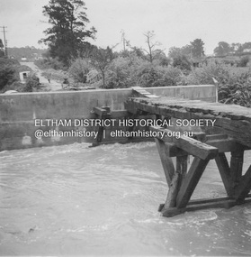
Slide, Floodwater, Main drain in Susan Street, Eltham, November 1971, 1971
... Eltham, floods, Susan Street...Eltham District Historical Society Inc 728 Main Rd Eltham melbourne Eltham, floods, Susan Street 35 mm colour positive transparency Mount - Agfacolor Service (Blue) Floodwater, Main drain in Susan Street, Eltham, November 1971 Slide Slide ...35 mm colour positive transparency Mount - Agfacolor Service (Blue)eltham, floods, susan street -
 Eltham District Historical Society Inc
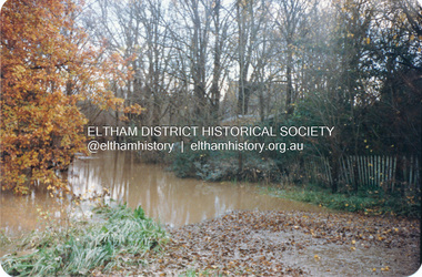
Photograph, Graeme Hardiman, Diamond Creek in flood, Susan Street, Eltham, 6 June 1989
... Diamond Creek in flood, Susan Street, Eltham...Pty Ltd Diamond Creek (Creek) Eltham floods Floodwater P.J. Timber & Trading Co Pty Ltd Susan Street Colour print 10 x 15 cm Diamond Creek in flood, Susan Street, Eltham Photograph Photograph Graeme Hardiman ...Opposite P.J. Timber and Trading Co. Pty Ltddiamond creek (creek), eltham, floods, floodwater, p.j. timber & trading co pty ltd, susan street -
 Eltham District Historical Society Inc
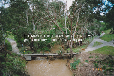
Photograph, Fay Bridge, Flood damage to footbridges over the Diamond Creek, Eltham, 14 November 2004
... Eltham melbourne Significant flood events occurred Nov-Dec 2004 and Jan-Feb 2005. Fay Bridge Collection 2004-11-14 Bridge Street Bridge Diamond Creek (Creek) Diamond Street Bridge Flood damage floods Floodwater Footbridge main road bridge Susan Street Oval Withers Way 5 images - scanned from colour prints on loan Flood damage to footbridges over the Diamond Creek, Eltham Photograph Photograph Fay Bridge ...Significant flood events occurred Nov-Dec 2004 and Jan-Feb 2005.fay bridge collection, 2004-11-14, bridge street bridge, diamond creek (creek), diamond street bridge, flood damage, floods, floodwater, footbridge, main road bridge, susan street oval, withers way -
 Eltham District Historical Society Inc
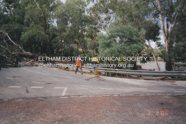
Photograph, Fay Bridge, Diamond Creek in flood, Eltham, 3 February 2005
... Eltham District Historical Society Inc 728 Main Rd Eltham melbourne Significant flood events occurred Nov-Dec 2004 and Jan-Feb 2005. Fay Bridge Collection Bridge Street Bridge Diamond Creek (Creek) floods Floodwater Footbridge main road bridge Susan Street Oval Diamond Street Eltham 14 images - scanned from colour prints on loan Diamond Creek in flood, Eltham Photograph Photograph Fay Bridge ...Significant flood events occurred Nov-Dec 2004 and Jan-Feb 2005.fay bridge collection, bridge street bridge, diamond creek (creek), floods, floodwater, footbridge, main road bridge, susan street oval, diamond street, eltham -
 Eltham District Historical Society Inc
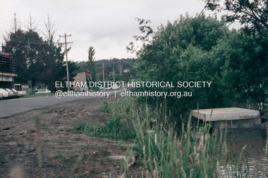
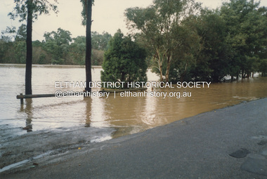
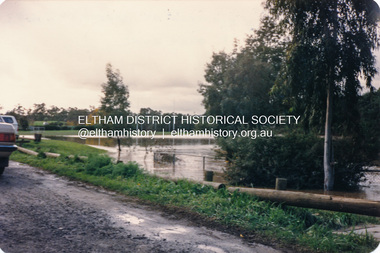
Photograph, Diamond Creek floodwater, Eltham
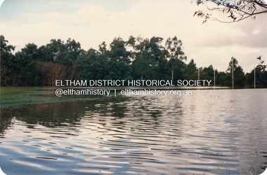
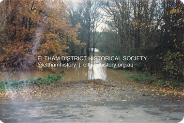
... Eltham District Historical Society Inc 728 Main Rd Eltham melbourne diamond creek floods etham dalton street susan street Four colour photographs of Diamond Creek floods in Susan Street and Dalton Street area. 1. ...Four colour photographs of Diamond Creek floods in Susan Street and Dalton Street area. 1. Floodwater of Diamond Creek spreading towards Susan Street over the oval 2. Floodwater of Diamond Creek spreading towards Susan Street over the oval 3. Diamond Creek Trail from Dalton Street 4. Diamond Creek Trail from Dalton Streetdiamond creek, floods, etham, dalton street, susan street -
 Eltham District Historical Society Inc
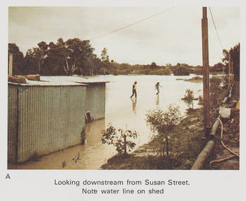
Work on paper (Sub-Item) - Photograph, Flooding, looking downstream from Susan Street, Eltham 8 April 1977
... Eltham melbourne Colour photograph. Looking downstream from Susan Street, Eltham , 8 April 1977. Note water line on shed flood diamond creek flooding Susan Street Image printed on A4 page from 04997 Diamond Creek Basin Study, 1980 Flooding, looking downstream from Susan Street, Eltham 8 April 1977 Work on paper Photograph ...Colour photograph. Looking downstream from Susan Street, Eltham , 8 April 1977. Note water line on shed flood, diamond creek, flooding, susan street -
 Eltham District Historical Society Inc
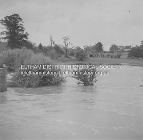
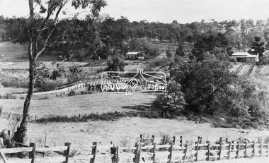
Album - Photograph, J.A. McDonald, Eltham-Greensborough Road, 18 Oct. 1956
... Bridge Street Bridge Flooding on Hill’s property 18th October 1956 This view is looking west north west from the Bridge Street Bridge across the present day Eltham Skatepark. The shed visibile in the distance is directly opposite Brisbane Street where it used to run into Susan Street but now turns the corner. ...Eltham District Historical Society Inc 728 Main Rd Eltham melbourne Bridge Street Bridge Flooding on Hill’s property 18th October 1956 This view is looking west north west from the Bridge Street Bridge across the present day Eltham Skatepark. The shed visibile in the distance is directly opposite Brisbane Street where it used to run into Susan ...Bridge Street Bridge Flooding on Hill’s property 18th October 1956 This view is looking west north west from the Bridge Street Bridge across the present day Eltham Skatepark. The shed visibile in the distance is directly opposite Brisbane Street where it used to run into Susan Street but now turns the corner. To the right of the shes is the site for present-dayHarris Plumbing which was formerly occupied by Sibbel Builders; to the left the site now occupied by Bunnings. At the skyline to the right of centreeline is a gap in the trees where the railway line runs. The Silver Street bridge over the railway is visible. Beware!.. our rivers are rising (1956, October 19). The Argus (Melbourne, Vic. : 1848 - 1957), p. 1. Retrieved August 24, 2022, from http://nla.gov.au/nla.news-article84392304Record of various Shire of Eltham infrastructure works undertaken during the period of 1952-1962 involving bridge and road reconstruction projects, sometimes with Eltham Shire Council Project Reference numbers quoted. It was during this period that a number of significant improvements were made to roads and new bridges constructed within the shire that remain in place as of present day (2022). In many situations, the photos provide a tangible visible record of infrastructure that existed throughout the early days of the Shire. The album was put together by or under the direction of the Shire Engineer, J.A. McDonald.infrastructure, road construction, shire of eltham, bridge construction, bridge street bridge, eltham, eltham-greensborough road, 1956-10-18, diamond creek (creek), floods, floodwater, hill property, silver street bridge -
 Eltham District Historical Society Inc
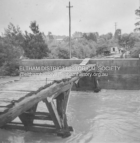
Album - Photograph, J.A. McDonald, Eltham-Greensborough Road, 18 Oct. 1956
... Eltham District Historical Society Inc 728 Main Rd Eltham melbourne Bridge Street Bridge Flood level on Greensborough pier 18th October 1956 View looking west across the Diamond Creek and tempoary walking access bridge towards intersection of Susan Street. ...Bridge Street Bridge Flood level on Greensborough pier 18th October 1956 View looking west across the Diamond Creek and tempoary walking access bridge towards intersection of Susan Street. The building visible on centreeline is the present-day SES facility. Beware!.. our rivers are rising (1956, October 19). The Argus (Melbourne, Vic. : 1848 - 1957), p. 1. Retrieved August 24, 2022, from http://nla.gov.au/nla.news-article84392304Record of various Shire of Eltham infrastructure works undertaken during the period of 1952-1962 involving bridge and road reconstruction projects, sometimes with Eltham Shire Council Project Reference numbers quoted. It was during this period that a number of significant improvements were made to roads and new bridges constructed within the shire that remain in place as of present day (2022). In many situations, the photos provide a tangible visible record of infrastructure that existed throughout the early days of the Shire. The album was put together by or under the direction of the Shire Engineer, J.A. McDonald.infrastructure, road construction, shire of eltham, bridge construction, bridge street bridge, eltham, eltham-greensborough road, 1956-10-18, diamond creek (creek), floods, floodwater, silver street bridge -
 Eltham District Historical Society Inc
Album - Photograph, J.A. McDonald, Eltham-Greensborough Road, 18 Oct. 1956
... Bridge Street Bridge Flood level on Eltham pier 18th October 1956 Looking west across the Diamond Creek to Susan Street intersection Beware!.. ...Eltham District Historical Society Inc 728 Main Rd Eltham melbourne Bridge Street Bridge Flood level on Eltham pier 18th October 1956 Looking west across the Diamond Creek to Susan Street intersection Beware!.. ...Bridge Street Bridge Flood level on Eltham pier 18th October 1956 Looking west across the Diamond Creek to Susan Street intersection Beware!.. our rivers are rising (1956, October 19). The Argus (Melbourne, Vic. : 1848 - 1957), p. 1. Retrieved August 24, 2022, from http://nla.gov.au/nla.news-article84392304Record of various Shire of Eltham infrastructure works undertaken during the period of 1952-1962 involving bridge and road reconstruction projects, sometimes with Eltham Shire Council Project Reference numbers quoted. It was during this period that a number of significant improvements were made to roads and new bridges constructed within the shire that remain in place as of present day (2022). In many situations, the photos provide a tangible visible record of infrastructure that existed throughout the early days of the Shire. The album was put together by or under the direction of the Shire Engineer, J.A. McDonald.infrastructure, road construction, shire of eltham, bridge construction, bridge street bridge, eltham, eltham-greensborough road, 1956-10-18, diamond creek (creek), floods, floodwater, silver street bridge -
 Eltham District Historical Society Inc
Photograph, View at Eltham, Vic, c.1924
... Eltham Town park in the early 1960s. The area was used as a garbage tip and filled above the flood plain of the creek. Development of the land for a park began in the early 1970s. The house on the right was owned for many years by the Hill family until Council bought it in the early 1960s. The house was built in the 1850s or 60s. The house on the left stood on what is now the southwest corner of Susan and Bridge Streets...Eltham Town park in the early 1960s. The area was used as a garbage tip and filled above the flood plain of the creek. Development of the land for a park began in the early 1970s. The house on the right was owned for many years by the Hill family until Council bought it in the early 1960s. The house was built in the 1850s or 60s. The house on the left stood on what is now the southwest corner of Susan and Bridge Streets ...Copy of possible Rose Stereograph Co. postcard “View at Eltham, Vic.”, c.1924 looking southwest from Main Road near York Street to Bridge Street and the original 1875 bridge across what is now the Alistair Knox Park The land in the foreground was first bought from the Crown by J.M. Holloway in 1851. The land was sub-divided and called "Little Eltham". Bridge Street was created as part of the sub-division. Most of the sub-division was residential lots but the creek valley was divided into lots for small farms. Council started to buy the land for the Eltham Town park in the early 1960s. The area was used as a garbage tip and filled above the flood plain of the creek. Development of the land for a park began in the early 1970s. The house on the right was owned for many years by the Hill family until Council bought it in the early 1960s. The house was built in the 1850s or 60s. The house on the left stood on what is now the southwest corner of Susan and Bridge Streets. The Braithwaite family was associated with this house. The double line of fencing in the foreground was a continuation of York Street to the creek. The Bridge Street bridge was built in 1875 and replaced in 1958. (Ref: Early view of Little Eltham; Byways of History by Colleen Ison, Publication unk, 24 August 1982) Reproduced on p61 of 'Pioneers & Painters' Date estimated on same as View at Hurstbridge featuring Wattle Valley EstateThis photo forms part of a collection of photographs gathered by the Shire of Eltham for their centenary project book,"Pioneers and Painters: 100 years of the Shire of Eltham" by Alan Marshall (1971). The collection of over 500 images is held in partnership between Eltham District Historical Society and Yarra Plenty Regional Library (Eltham Library) and is now formally known as the 'The Shire of Eltham Pioneers Photograph Collection.' It is significant in being the first community sourced collection representing the places and people of the Shire's first one hundred years.Digital image 120 format B&W negative Prints 17 x 25 cm and 10 x 15 cmsepp, shire of eltham pioneers photograph collection, eltham, bridge street, bridge, alistair knox park, braithwaite, bridge street bridge, eltham town park, hill family home, main road, pioneers and painters, york street -
 Eltham District Historical Society Inc
Book, Diamond Creek Basin Study. Part 1, A Compendium of Factors Relevant to Stormwater Flows, 1980
... street bridge...drainage works...eltham lower park...eltham town park...eltham trestle bridge...eltham west drains...eltham...erosion...flood management...floods...footbridge...glen katherine estate...gold mining...gum glade...hurstbridge...kangaroo ground...kinglake escarpment...kinglake national park...latiners hat factory...main road bridge...main road...masons falls...melbourne metropolitan board of works, monash bridge...mount sugarloaf...nillumbik park...orchards...railway culvert...railway line...ramptons road...real estate advertisement...research creek...st helena east drain...st helena road...st helena...storm sewers...stormwater...sugarloaf-preston transfer main crossing...susan...Eltham District Historical Society Inc 728 Main Rd Eltham melbourne Basin Studies are studies to evaluate water supply and demand and help ensure reliable water supplies by identifying strategies to address imbalances in water supply and demand. aerial photographs allendale road arthurs creek mine arthurs creek road bridge arthurs creek bald spur look-out bank protection bolton steet bridge street bridge bridge street bridges challenger street chute street construction coolaroo drive culvert deep creek diamond creek basin diamond creek region diamond creek diamond street bridge drainage works eltham lower park eltham town park eltham trestle bridge eltham west drains eltham erosion flood management floods footbridge glen katherine estate gold mining gum glade hurstbridge kangaroo ground kinglake escarpment kinglake national park latiners hat factory main road bridge main road masons falls melbourne metropolitan board of works, monash bridge mount sugarloaf nillumbik park orchards railway culvert railway line ramptons road real estate advertisement research creek st helena east drain st helena road st helena storm sewers stormwater sugarloaf-preston transfer main crossing susan street union mine village pond water flow watkins street wattletree road weidlich road wingrove park yarra river zig zag road water supply basin study Spiral Bound. 157 leaves in various foliations (some folded) : illustrated. ...Basin Studies are studies to evaluate water supply and demand and help ensure reliable water supplies by identifying strategies to address imbalances in water supply and demand.Spiral Bound. 157 leaves in various foliations (some folded) : illustrated. (some colour.), maps (some colour.)aerial photographs, allendale road, arthurs creek mine, arthurs creek road bridge, arthurs creek, bald spur look-out, bank protection, bolton steet, bridge street bridge, bridge street, bridges, challenger street, chute street, construction, coolaroo drive, culvert, deep creek, diamond creek basin, diamond creek region, diamond creek, diamond street bridge, drainage works, eltham lower park, eltham town park, eltham trestle bridge, eltham west drains, eltham, erosion, flood management, floods, footbridge, glen katherine estate, gold mining, gum glade, hurstbridge, kangaroo ground, kinglake escarpment, kinglake national park, latiners hat factory, main road bridge, main road, masons falls, melbourne metropolitan board of works, monash bridge, mount sugarloaf, nillumbik park, orchards, railway culvert, railway line, ramptons road, real estate advertisement, research creek, st helena east drain, st helena road, st helena, storm sewers, stormwater, sugarloaf-preston transfer main crossing, susan street, union mine, village pond, water flow, watkins street, wattletree road, weidlich road, wingrove park, yarra river, zig zag road, water supply, basin study -
 Eltham District Historical Society Inc
Photograph, Diamond Creek floodwater, Eltham
... Eltham District Historical Society Inc 728 Main Rd Eltham melbourne diamond creek floods etham dalton street susan street Four colour photographs of Diamond Creek floods in Susan Street and Dalton Street area. 1. ...Four colour photographs of Diamond Creek floods in Susan Street and Dalton Street area. 1. Floodwater of Diamond Creek spreading towards Susan Street over the oval 2. Floodwater of Diamond Creek spreading towards Susan Street over the oval 3. Diamond Creek Trail from Dalton Street 4. Diamond Creek Trail from Dalton Streetdiamond creek, floods, etham, dalton street, susan street -
 Eltham District Historical Society Inc
Photograph, Diamond Creek floodwater, Eltham
... Eltham District Historical Society Inc 728 Main Rd Eltham melbourne diamond creek floods etham dalton street susan street Four colour photographs of Diamond Creek floods in Susan Street and Dalton Street area. 1. ...Four colour photographs of Diamond Creek floods in Susan Street and Dalton Street area. 1. Floodwater of Diamond Creek spreading towards Susan Street over the oval 2. Floodwater of Diamond Creek spreading towards Susan Street over the oval 3. Diamond Creek Trail from Dalton Street 4. Diamond Creek Trail from Dalton Streetdiamond creek, floods, etham, dalton street, susan street