Showing 10 items matching "eltham west drains"
-
 Eltham District Historical Society Inc
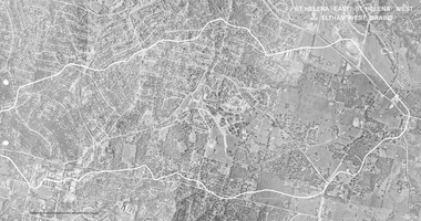
Work on paper (Sub-Item) - Photograph, St Helena East, St Helena West and Eltham West drains, ca 1980
... St Helena East, St Helena West and Eltham West drains...Eltham District Historical Society Inc 728 Main Rd Eltham melbourne black and white aerial photograph with boundary and drains marked over three page fold out eltham St Helena drains aerial view Image printed on fold out A4 page from 04997 Diamond Creek Basin Study, 1980 St Helena East, St Helena West and Eltham West drains Work on paper Photograph ...black and white aerial photograph with boundary and drains marked over three page fold out eltham, st helena, drains, aerial view -
 Eltham District Historical Society Inc
Book, Diamond Creek Basin Study. Part 1, A Compendium of Factors Relevant to Stormwater Flows, 1980
... ...eltham west drains...Eltham District Historical Society Inc 728 Main Rd Eltham melbourne Basin Studies are studies to evaluate water supply and demand and help ensure reliable water supplies by identifying strategies to address imbalances in water supply and demand. aerial photographs allendale road arthurs creek mine arthurs creek road bridge arthurs creek bald spur look-out bank protection bolton steet bridge street bridge bridge street bridges challenger street chute street construction coolaroo drive culvert deep creek diamond creek basin diamond creek region diamond creek diamond street bridge drainage works eltham lower park eltham town park eltham trestle bridge eltham west drains eltham erosion flood management floods footbridge glen katherine estate gold mining gum glade hurstbridge kangaroo ground kinglake escarpment kinglake national park latiners hat factory main road bridge main road masons falls melbourne metropolitan board of works, monash bridge mount sugarloaf nillumbik park orchards railway culvert railway line ramptons road real estate advertisement research creek st helena east drain st helena road st helena storm sewers stormwater sugarloaf-preston transfer main crossing susan street union mine village pond water flow watkins street wattletree road weidlich road wingrove park yarra river zig zag road water supply basin study Spiral Bound. 157 leaves in various foliations (some folded) : illustrated. ...Basin Studies are studies to evaluate water supply and demand and help ensure reliable water supplies by identifying strategies to address imbalances in water supply and demand.Spiral Bound. 157 leaves in various foliations (some folded) : illustrated. (some colour.), maps (some colour.)aerial photographs, allendale road, arthurs creek mine, arthurs creek road bridge, arthurs creek, bald spur look-out, bank protection, bolton steet, bridge street bridge, bridge street, bridges, challenger street, chute street, construction, coolaroo drive, culvert, deep creek, diamond creek basin, diamond creek region, diamond creek, diamond street bridge, drainage works, eltham lower park, eltham town park, eltham trestle bridge, eltham west drains, eltham, erosion, flood management, floods, footbridge, glen katherine estate, gold mining, gum glade, hurstbridge, kangaroo ground, kinglake escarpment, kinglake national park, latiners hat factory, main road bridge, main road, masons falls, melbourne metropolitan board of works, monash bridge, mount sugarloaf, nillumbik park, orchards, railway culvert, railway line, ramptons road, real estate advertisement, research creek, st helena east drain, st helena road, st helena, storm sewers, stormwater, sugarloaf-preston transfer main crossing, susan street, union mine, village pond, water flow, watkins street, wattletree road, weidlich road, wingrove park, yarra river, zig zag road, water supply, basin study -
 Eltham District Historical Society Inc
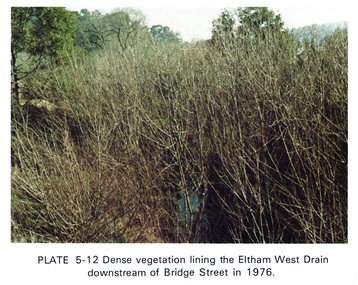
Work on paper (Sub-Item) - Photograph, Dense vegetaton lining the Eltham West Drain downstream of Bridge Street in 1976, 1976
... Dense vegetaton lining the Eltham West Drain downstream of Bridge Street in 1976......eltham west drain...Colour photograph of dense vegetation lining the Eltham West drain downstream of Bridge Street, Eltham...Eltham District Historical Society Inc 728 Main Rd Eltham melbourne Colour photograph of dense vegetation lining the Eltham West drain downstream of Bridge Street, Eltham eltham vegetation weeds eltham west drain Image printed on A4 page from 04997 Diamond Creek Basin Study, 1980 Dense vegetaton lining the Eltham West Drain downstream of Bridge Street in 1976 Work on paper Photograph ...Colour photograph of dense vegetation lining the Eltham West drain downstream of Bridge Street, Elthameltham, vegetation, weeds, eltham west drain -
 Eltham District Historical Society Inc
Photograph - Digital Photograph, Marguerite Marshall, Smith Dam, Karingal Drive, Eltham, 19 September 2006
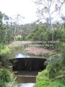
... The concrete arched dam across the Eltham West Drain was built in 1940 by B.A. Smith's son and engineer, D. ...The concrete arched dam across the Eltham West Drain was built in 1940 by B.A. Smith's son and engineer, D. ...The dam at the entrance to the Nerreman Gateway in Eltham was built according to an internationally acclaimed theory developed by the builder's father. In 1920, Victorian engineer B.A. Smith was awarded the American Society of Civil Engineers J. James R. Cross Gold Medal for his Technical Paper titled 'Arched Dams'. It was the first time this medal had been awarded outside the United States. The concrete arched dam across the Eltham West Drain was built in 1940 by B.A. Smith's son and engineer, D. B. (Bernie) Smith to water the 24 acre (9.75 ha) hobby farm owned by himself and new wife, Isa Smith. Upon completion of the dam a pump-house was constructed beside the creek but before the water could be pumped up the hill they had to dig a trench and lay 500m of 100mm water main to an elevated holding tank. The Smiths made the pump-house their home for several years until they constructed their home at the top of the hill overlooking Eltham and views extending to Kinglake. Following Bernie's death in 1983, Nerreman Park was subdivided between 1993 and 1995. Gordon Ford designed the landscaping and the pump-house was demolished. Covered under Heritage Overlay, Nillumbik Planning Scheme. Published: Nillumbik Now and Then / Marguerite Marshall 2008; photographs Alan King with Marguerite Marshall.; p137 The dam at the entrance to the Nerreman Gateway in Eltham, was built according to an internationally acclaimed theory developed by the builder’s father. In 1920, Victorian engineer B A Smith was awarded the American Society of Civil Engineers J. James R. Croes Gold Medal, for his Technical Paper titled Arched Dams. It was the first time this medal had been awarded outside America. An international example of the application of Smith’s work can be found in the design of the Hoover Dam on the Colorado River, Nevada, USA. Built between 1930 and 1936, it is recognised by the ASCE as one of ‘America’s Seven Modern Civil Engineering Wonders’.1 The concrete arched dam across the Eltham West Drain was built by B A Smith’s son and engineer, D B (Bernie) Smith. Bernie’s dam followed his father’s theory, having a curvature that takes maximum advantage of concrete’s great strength in compression. The water load is carried into the abutments because of this curvature, which permits a wall thickness of only 225 millimetres thick at its crest, despite the dam’s capacity of more than 4.5 megalitres. The Eltham dam was designed to water the 24 acre (9.75 ha) hobby farm belonging to newly married couple Bernie and Isa Smith. Bernie, from Armadale, and Isa, from a farm at Tyntynder near Swan Hill, were attracted to the hilly topography and the creek running through the property. It extended from Ryans Road, Eltham, to Karingal Drive, Montmorency and was adjacent to Meruka Park. The Smiths named it Nerreman Park using the Aboriginal word Nerreman meaning ‘River Bend’ as their creek had a pronounced bend.2 In 1940 the first thing Bernie did was to build a dam, and with Isa’s help, a pump-house, to secure a water supply for their cattle, pigs, chickens, orchard and vegetable gardens. It was also available for the fire-plugs, which they placed all over the property in case of bushfire. The couple built the pump-house beside the creek and installed a Tange three-plunger pump, which had originally supplied the City of Wodonga with water. But before the Smiths could pump water up the hill from the dam they had to dig a trench and lay about 550 yards (500m) of a four-inch (100mm) water main up to an elevated holding tank. The trench was dug with a single furrow plough drawn by an old draught horse. Living in rough conditions did not deter the Smiths, who made the pump-house their home, where they still lived when their first child was born in 1944. They later built their home at the top of their property overlooking Eltham, with magnificent views to Kinglake, the Dandenong Ranges and Melbourne. From 1946 it took them almost 20 years to complete the 36-square house with its 12-foot (3.6m) high ceilings. Material for the concrete roof and walls faced with sandstone, was ripped out of the ground on their property by plough pulled by tandem Clydesdale horses. Isa was a strong woman – two days before their second child was born – she set three huge sandstone boulders in place in the bottom wall of the garage. She also mixed all the cement for the house. A collapsed kitchen wall did not discourage her from rebuilding it in a week, while her husband was away working in the country. She later recalled: ‘We stood back to admire this beautiful wall we’d built and while we were looking at it, it came tumbling down’.3 Following Bernie’s death in 1983, Nerreman Park was subdivided, between 1993 and 1995. Local Gordon Ford designed the landscaping and the pump-house was pulled down. But the dam remains as a reminder of exceptional engineering4 – and of a remarkable couple.This collection of almost 130 photos about places and people within the Shire of Nillumbik, an urban and rural municipality in Melbourne's north, contributes to an understanding of the history of the Shire. Published in 2008 immediately prior to the Black Saturday bushfires of February 7, 2009, it documents sites that were impacted, and in some cases destroyed by the fires. It includes photographs taken especially for the publication, creating a unique time capsule representing the Shire in the early 21st century. It remains the most recent comprehenesive publication devoted to the Shire's history connecting local residents to the past. nillumbik now and then (marshall-king) collection, eltham, karingal drive, smiths dam, bernie smith, gordon ford, isa smith, nerreman gateway, nerreman park estate, dams -
 Eltham District Historical Society Inc
Document - Folder, Smith, Isa Bernhard
... Eltham...Nerreman Creek...West Main Drain...Isa Bernhard Smith Ryans Road Eltham Karringal Drive Eltham Nerreman Creek West Main Drain Eltham War Memorial Trust Eltham St Margaret's Church Eltham Eltham Pony Club Whelan the Wrecker Prahran Technical College Melbourne Grammar School Newspaper clippings, A4 photocopies, etc Smith, Isa Bernhard Document Folder ...Isa grew up near Tyntynder, Swan Hill. After she married the couple lived at Nerreman Park, eventually building their own house. Contents Newspaper article: "Isa's hard work pays off", Diamond Valley News, 17 December 1985. Biography of Isa Bernhard Smith. Newspaper clippings, A4 photocopies, etcisa bernhard smith, ryans road eltham, karringal drive eltham, nerreman creek, west main drain eltham, war memorial trust eltham, st margaret's church eltham, eltham pony club, whelan the wrecker, prahran technical college, melbourne grammar school -
 Eltham District Historical Society Inc
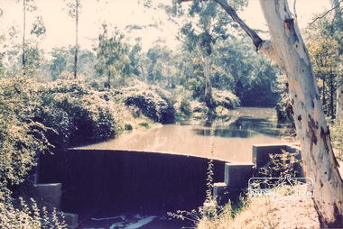
Photograph, Smiths Dam, Karingal Drive, Eltham
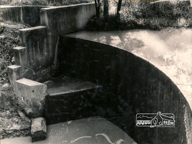
... ...eltham west drain...Eltham District Historical Society Inc 728 Main Rd Eltham melbourne dams karingal drive eltham d.b smith eltham west drain karingal creek Colour photograph Smiths Dam, Karingal Drive, Eltham Photograph ...Colour photographdams, karingal drive, eltham, d.b smith, eltham west drain, karingal creek -
 Eltham District Historical Society Inc
Photograph, George W. Bell, Smiths Dam, Eltham, 1961, 1961
... ...eltham west drain...Eltham District Historical Society Inc 728 Main Rd Eltham melbourne karingal drive st helena road d.b smith eltham west drain karingal creek st helena creek dams george w bell collection Black and white photograph of concrete dam on Smith property Karingal Drive Eltham 1961 Smiths Dam, Eltham, 1961 Photograph George W. ...Black and white photograph of concrete dam on Smith property Karingal Drive Eltham 1961karingal drive, st helena road, d.b smith, eltham west drain, karingal creek, st helena creek, dams, george w bell collection -
 Eltham District Historical Society Inc
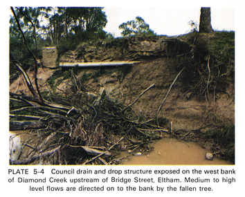
Work on paper (Sub-Item) - Photograph, Council drain and drop structure exposed on the west bank of Diamond Creek upstream of Bridge Street, Eltham
... Council drain and drop structure exposed on the west bank of Diamond Creek upstream of Bridge Street, Eltham...Colour photograph of a muddy creek (probably after a downpour) showing council drain and drop structure exposed on the west bank of Diamond Creek upstream of Bridge Street, Eltham. ...Eltham District Historical Society Inc 728 Main Rd Eltham melbourne Colour photograph of a muddy creek (probably after a downpour) showing council drain and drop structure exposed on the west bank of Diamond Creek upstream of Bridge Street, Eltham. ...Colour photograph of a muddy creek (probably after a downpour) showing council drain and drop structure exposed on the west bank of Diamond Creek upstream of Bridge Street, Eltham. Mediun to high level water flows are directed on to the bank by the fallen tree.eltham, creek, diamond creek, bridge street, drainage, waterflow, vegetation -
 Eltham District Historical Society Inc
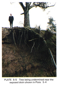
Work on paper (Sub-Item) - Photograph, Tree being undermined near an exposed drain on the west bank of Diamond Creek upstream of Bridge Street, Eltham
... Tree being undermined near an exposed drain on the west bank of Diamond Creek upstream of Bridge Street, Eltham...Eltham. The tree has been undermined with roots exposed near a council drain. eltham diamond creek bridge street drainage roots tree Image printed on A4 page from 04997 Diamond Creek Basin Study, 1980 Tree being undermined near an exposed drain on the west bank of Diamond Creek upstream of Bridge Street, Eltham Work on paper Photograph ...Colour photograph of tree on the side of the Diamond Creek upstream at Bridge Street, Eltham. The tree has been undermined with roots exposed near a council drain.eltham, diamond creek, bridge street, drainage, roots, tree -
 Eltham District Historical Society Inc
Photograph, Looking west near 942 Main Road, Hurstbridge, c. Oct 1987, 1987
... Shire of Eltham Engineering Department Providing the resources to undertake • Survey, design, consultation • Road construction and maintenance • Bridge construction and maintenance • Street sweeping • Drain and pit cleaning • Traffic engineering installation and maintenance • Garbage collection • Tip management, land reclamation and beautification • Maintenance of community buildings • Provision of community and recreation facilities Display panel, Eltham Festival, Heidelberg-Kinglake Road, Hurstbridge, Hurstbridge Milk Bar, Infrastructure, Main Road, MM, shire of eltham, Yvonne's Dressmaking and Alteration Service Photo print mounted on card Looking west near 942 Main Road, Hurstbridge, c. ...Yvonne's Dressmaking and Alteration Service at 942 Main Road. Formerly a bakery, the building was demolished in 1990 and is now the site of Hurstbridge Saddlery. The milkbar is down the road, brick wall with a blue sign on it. There's still an older house next to the milkbar, but that's hidden from view in this shot as it's further back from the road. Date based on other similar display panels visible in images of the Shire of Eltham display at the Eltham Community Festival, 7 November 1987. Shire of Eltham Engineering Department Providing the resources to undertake • Survey, design, consultation • Road construction and maintenance • Bridge construction and maintenance • Street sweeping • Drain and pit cleaning • Traffic engineering installation and maintenance • Garbage collection • Tip management, land reclamation and beautification • Maintenance of community buildings • Provision of community and recreation facilitiesPhoto print mounted on carddisplay panel, eltham festival, heidelberg-kinglake road, hurstbridge, hurstbridge milk bar, infrastructure, main road, mm, shire of eltham, yvonne's dressmaking and alteration service