Showing 152 items matching "eltham-hurstbridge railway line"
-
 Eltham District Historical Society Inc
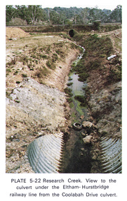
Work on paper (Sub-Item) - Photograph, Research Creek. View to the culvert under the Eltham-Hurstbridge railway line from the Coolabah Drive culvert
... View to the culvert under the Eltham-Hurstbridge railway line from the Coolabah Drive culvert...View to the culvert under the Eltham-Hurstbridge railway line from the Coolabah Drive culvert, Eltham...View to the culvert under the Eltham-Hurstbridge railway line from the Coolabah Drive culvert Work on paper Photograph ...Colour photograph of Research Creek. View to the culvert under the Eltham-Hurstbridge railway line from the Coolabah Drive culvert, Elthameltham, research creek, coolabah drive, culvert, eltham hurstbridge railway, drain -
 Eltham District Historical Society Inc
Audio - Audio Recording, Mark Cauchi; Eltham to Hurstbridge Railway – The line through the valley of the Diamond, 22 Apr 2022
... Mark Cauchi; Eltham to Hurstbridge Railway – The line through the valley of the Diamond...Eltham District Historical Society...Meeting...Society Meeting...AGM...Hurstbridge Line...Mark Cauchi...Railway... Mark Cauchi Railway Line 1:18:42 duration Digital MP3 file; 27.0 MB Mark Cauchi; Eltham to Hurstbridge Railway – The line through the valley of the Diamond Audio Audio Recording Eltham District Historical Society ...At this meeting we are pleased to have as our guest speaker Mark Cauchi, who is an active railway historian and a long-term member of the former Australian Railway Historical Society. Mark will provide a glimpse into the extension of the railway from Eltham to Hurstbridge, using various historic and current-day railway images.1:18:42 duration Digital MP3 file; 27.0 MBaudio recording, eltham, eltham district historical society, meeting, society meeting, agm, hurstbridge line, mark cauchi, railway line -
 Eltham District Historical Society Inc
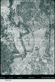
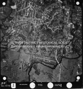
Photograph - Aerial Photograph, Landata, Eltham, Main Rd; Railway Rd to Zig Zag Rd, Dec. 1945
... ...Eltham-Hurstbridge Railway line...Eltham District Historical Society Inc 728 Main Rd Eltham melbourne Centred on present day Edendale Farm from Glen Park rd to Zig Zag Rd Historic Aerial Imagery Source: Landata.vic.gov.au Aerial Photo Details: Project No :5 Project : MELBOURNE AND METROPOLITAN AREA PROJECT Run : 37 Frame : 60549 Date : 12/1945 Film Type : B/W Camera : EAG4 Flying Height : 10200 Scale : 6000 Film Number : 196 GDA2020 : 37°42'12"S, 145°09'09"E MGA2020 : 337141, 5825486 (55) Melways : 21 K2 (ed. 42) Aerial Photo Eltham Edendale Farm eltham - yarra glen road Eltham-Hurstbridge Railway line Gastons Homestead Gastons Road Glen Park Road Main Road Park Road railway road Wattletree Road Zig Zag Road Neil Webster Collection A3 photo print and electronic PDF file Eltham, Main Rd; Railway Rd to Zig Zag Rd Photograph Aerial Photograph Landata ...Centred on present day Edendale Farm from Glen Park rd to Zig Zag Rd Historic Aerial Imagery Source: Landata.vic.gov.au Aerial Photo Details: Project No :5 Project : MELBOURNE AND METROPOLITAN AREA PROJECT Run : 37 Frame : 60549 Date : 12/1945 Film Type : B/W Camera : EAG4 Flying Height : 10200 Scale : 6000 Film Number : 196 GDA2020 : 37°42'12"S, 145°09'09"E MGA2020 : 337141, 5825486 (55) Melways : 21 K2 (ed. 42)aerial photo, eltham, edendale farm, eltham - yarra glen road, eltham-hurstbridge railway line, gastons homestead, gastons road, glen park road, main road, park road, railway road, wattletree road, zig zag road, neil webster collection -
 Eltham District Historical Society Inc
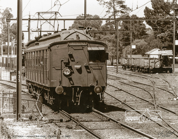
Photograph, G.L. Coop, Eltham - Hurstbridge single carriage Tait train near Eltham Station, c.1980, 1980c
... eltham...train...Eltham Railway Station...Eltham-Hurstbridge Railway line...Warren Fuel Merchant eltham train Eltham Railway Station Eltham-Hurstbridge Railway line Red Rattler Single Carriage Train a.r warren Sepia photograph Eltham - Hurstbridge single carriage Tait train near Eltham Station, c.1980 Photograph G.L. ...Inscribed on reverse 'Leaping Leena' for weekend use. Note sign for A.R. Warren Fuel MerchantSepia photographeltham, train, eltham railway station, eltham-hurstbridge railway line, red rattler, single carriage train, a.r warren -
 Eltham District Historical Society Inc
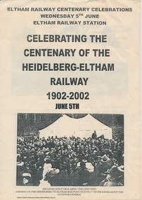
Folder, Centenary of the Heidelberg to Eltham Railway 1902-2002, 2001-2002
... heidelberg-eltham railway extension...hurstbridge railway line...Eltham Historical Society sub commttee for an event to acknowledge the centenary of the Heidelberg Eltham railway line in 2002. Includes copies of letters to various potential stakeholders and partners. A3 folded information leaftlet with historical information and photographs harry gilham collection heidelberg-eltham railway extension hurstbridge railway line centenary celebrations eltham district historical society HG Folders 110 8 Pages Centenary of the Heidelberg to Eltham Railway 1902-2002 Folder ...Meeting agenda to form Eltham Historical Society sub commttee for an event to acknowledge the centenary of the Heidelberg Eltham railway line in 2002. Includes copies of letters to various potential stakeholders and partners. A3 folded information leaftlet with historical information and photographs8 PagesHG Folders 110harry gilham collection, heidelberg-eltham railway extension, hurstbridge railway line, centenary celebrations, eltham district historical society -
 Eltham District Historical Society Inc
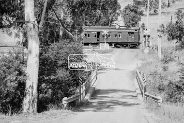
Photograph, George Coop, Single Motor Carriage 471M Tait (Red Rattler) train crossing Allendale Road, heading to Eltham station, 6 December 1980, 1980
... 471M, Allendale Road, Eltham, Hurstbridge Line, Railway Level Crossing, Red Rattler, Single Motor Carriage, Tait Train...Eltham and Hurstbridge stations. Looking east along Allendale Road, Eltham to the railway level crossing. The tree on the left remains today (2019) https://goo.gl/maps/zngEcUA29tEWFzuj7 471M, Allendale Road, Eltham, Hurstbridge Line, Railway Level Crossing, Red Rattler, Single Motor Carriage, Tait Train Digital TIFF file Scan of 35mm Ilford FP4 black and white transparency Single Motor Carriage 471M Tait (Red Rattler) train crossing Allendale Road, heading to Eltham station, 6 December 1980 Photograph George Coop ...The single carriage Tait regularly ran between Eltham and Hurstbridge stations. Looking east along Allendale Road, Eltham to the railway level crossing. The tree on the left remains today (2019) https://goo.gl/maps/zngEcUA29tEWFzuj7Digital TIFF file Scan of 35mm Ilford FP4 black and white transparency471m, allendale road, eltham, hurstbridge line, railway level crossing, red rattler, single motor carriage, tait train -
 Eltham District Historical Society Inc
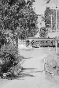
Photograph, George Coop, Single Motor Carriage 471M Tait (Red Rattler) train crossing Allendale Road, heading to Eltham station, 6 December 1980, 1980
... 471m, allendale road, eltham, hurstbridge line, railway level crossing, red rattler, single motor carriage, tait train...Eltham and Hurstbridge stations. Looking east along Allendale Road, Eltham to the railway level crossing. The tree on the left remains today (2019) https://goo.gl/maps/zngEcUA29tEWFzuj7 471m, allendale road, eltham, hurstbridge line, railway level crossing, red rattler, single motor carriage, tait train Digital TIFF file Scan of 35mm Ilford FP4 black and white transparency Single Motor Carriage 471M Tait (Red Rattler) train crossing Allendale Road, heading to Eltham station, 6 December 1980 Photograph George Coop ...The single carriage Tait regularly ran between Eltham and Hurstbridge stations. Looking east along Allendale Road, Eltham to the railway level crossing. The tree on the left remains today (2019) https://goo.gl/maps/zngEcUA29tEWFzuj7Digital TIFF file Scan of 35mm Ilford FP4 black and white transparency471m, allendale road, eltham, hurstbridge line, railway level crossing, red rattler, single motor carriage, tait train -
 Eltham District Historical Society Inc
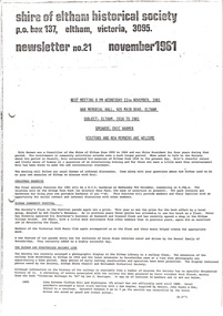
Newsletter, Newsletter, No. 21 November 1981
... Contents: • Next meeting – Guest speaker Eric Harmer: Eltham, 1918-1981 • Christmas Barbecue • Eltham Community Festival • The Eltham and Hurstbridge railway line ...Eltham District Historical Society Inc 728 Main Rd Eltham melbourne Contents: • Next meeting – Guest speaker Eric Harmer: Eltham, 1918-1981 • Christmas Barbecue • Eltham Community Festival • The Eltham and Hurstbridge railway line The Shire of Eltham Historical Society was formed in October 1967. ...Contents: • Next meeting – Guest speaker Eric Harmer: Eltham, 1918-1981 • Christmas Barbecue • Eltham Community Festival • The Eltham and Hurstbridge railway line The Shire of Eltham Historical Society was formed in October 1967. The first newsletter of the Society was issued May 1978 and has been published continuously ever since on a bi-monthly basis. With the cessation of the Shire of Eltham in late 1994, the Society's name was revised to Eltham District Historical Society and this name first appeared with issue No. 103, July 1995. The collection of the Society's newsletters provides a valuable resource on the history of the Society's activities, office bearers and committee members, guest speakers and subjects of historical interest pertinent to the former Shire of Eltham and the Eltham District.A4 photocopied newsletter distributed to membersnewsletter, eltham district historical society, shire of eltham historical society -
 Eltham District Historical Society Inc
Book, Nillumbik Historical Society, Things You Didn't Know about the Eltham Diamond Creek Hurstbridge Railway, by Jock Ryan, 2003
... Brief history of Eltham Diamond Creek Hurstbridge railway line...Eltham District Historical Society Inc 728 Main Rd Eltham melbourne Brief history of Eltham Diamond Creek Hurstbridge railway line 10p, 30 cm Things You Didn't Know about the Eltham Diamond Creek Hurstbridge Railway, by Jock Ryan Book Nillumbik Historical Society ...Brief history of Eltham Diamond Creek Hurstbridge railway line10p, 30 cm -
 Greensborough Historical Society
Article, Keith Patterson et al, The Eltham/Hurstbridge Railway, 1912-2012
... Account of the extension and electrification of the Eltham to Hurstbridge railway line. Article is in two parts: Part 1: Steam days 1912-1925, published in Diamond Creek News, Autumn 2012; Part 2: Electrification 1926-2012, published in Nillumbik Custodian, v. 8, Issue 2, June 2012...Greensborough Historical Society 34A Glenauburn Road Lower Plenty Lower Plenty melbourne Account of the extension and electrification of the Eltham to Hurstbridge railway line. Article is in two parts: Part 1: Steam days 1912-1925, published in Diamond Creek News, Autumn 2012; Part 2: Electrification 1926-2012, published in Nillumbik Custodian, v. 8, Issue 2, June 2012 eltham hurstbridge railways hurstbridge rail line 3 pages, printed both sides. ...Account of the extension and electrification of the Eltham to Hurstbridge railway line. Article is in two parts: Part 1: Steam days 1912-1925, published in Diamond Creek News, Autumn 2012; Part 2: Electrification 1926-2012, published in Nillumbik Custodian, v. 8, Issue 2, June 20123 pages, printed both sides. Text and illus. (some col.).eltham, hurstbridge, railways, hurstbridge rail line -
 Eltham District Historical Society Inc
Film - Video (VHS), Nillumbik Shire Council, The Nillumbik Story, 1996
... railway...Doncaster...dunmoochin...Education program...EEPS...Eltham...Eltham East Primary School...Eltham East Primary School Band...Eltham Library Community Gallery...Eltham Lower Park...Environment...fishing...flour mill...fruit growing...fruiterer...Garden Hill...Gold mining...Green Wedge...Greensborough...Heritage Trail...Hurstbridge Railway Line...CREDITS Music by John Greenfield from the CD Sweet Rain “The Snow Tree”, Uncle Music UNC 2001 Cameras - David Mirabella and Peter Farragher Editor – Olwyn Jones Written and Produced by Jason Cameron A Jason Cameron Proction for Nillumbik Shire Provides a record of the relatively newly created Shire of Nillumbik at the time and the features and attactions of the shire in its people arts, culture and environment video recording Arthurs Creek Arthurs Creek Landcare group Artists artists in residence Arts Arts Festival Authors BlackBerry Brock family Bulldozer Bulleen bushland sanctuary Caledonian gold rush Charles Reddington Clifton Pugh cottlesbridge Cypress rows developer Diamond Creek Diamond Creek Mine Diamond Reef Diamond Valley miniature railway Doncaster dunmoochin Education program EEPS Eltham Eltham East Primary School Eltham East Primary School Band Eltham Library Community Gallery Eltham Lower Park Environment fishing flour mill fruit growing fruiterer Garden Hill Gold mining Green Wedge Greensborough Heritage Trail Hurstbridge Railway Line jazz festival Jock Ryan Kangaroo Ground kangaroo ground tower Kinglake Maroondah Aqueduct Matcham Skipper Memorial Park Ming Mackay (1918-2009) Montsalvat Mudbrick houses Music musicians nesting area Nillumbik Historical Society Nillumbik Shire North Warrandyte Old timer Orchards Peter Brock Plenty River poets Population Recreation recreational activities revegetation Robert Hoddle Sandy Brock Shillinglaw Cottage Shire of Eltham War Memorial Sigmund Jorgensen St Andrews Hotel St Andrews Market Sugarloaf Reservoir Templestowe The Hill tourism Viewing platform Warrandyte water catchment area Watsons Creek Wedgetail eagle Whittlesea Wiregrass Gallery Wurundjeri Yarra River Jack Powell VHS Cassette (five copies) DVD (one copy) Converted to MP4 file format 0:22:00, 1.60GB The Nillumbik Story Film Video (VHS) Nillumbik Shire Council Jason Cameron David Mirabella Peter Farragher Olwyn Jones ...PART 1 – NILLUMBIK (00:00-07:17) Opening features various scenes around Nillumbik Shire. For 40,000 years Nillumbik was the home of the Wurundjeri people. Robert Hoddle gave the district its name. Jock Ryan, then president of Nillumbik Historical Society discusses the names Nillumbik and Diamond Creek. In the late 1830s white occupation began with gold found in Warrandyte in 1851 and 12 years later at Diamond Creek -the Diamond Reef which led to the Caledonian gold rush. Jock Ryan discusses the Diamond Creek mine, which was thriving until it burnt out in 1915. Large numbers of workmen moved into area in late 1870s to construct the Maroondah Aqueduct. With growing population of Melbourne, the nearby Yan Yean system had severely disrupted the flow of the Plenty River, forcing the closure of three flour mills there. The aqueduct came to the rescue carrying water 66km from Healesville to Preston. When the Diamond Creek gold mine burnt down the local economy suffered but fruit growing industry had already been established and Diamond Creek became a thriving fruit growing centre. Interview with Jack Powell, a long-time fruiterer at St Andrews market, his family had lived in the area for a hundred years, 3 to 4 generations, “a lot of hard work”. By the time the railway arrived fruit growing was no longer competitive. The railway brought the city closer and day trippers. The Green Wedge separates the shire from the more densely developed neighbours such as Whittlesea, Doncaster, Templestowe, Bulleen and Greensborough. Population at the time (1996) was 19,000 but links to the past remain strong. Mudbrick houses along the Heritage Trail The saving of Shillinglaw Cottage from demolition in 1963 and relocation brick by brick. PART 2 – ENVIRONMENT (07:18-14:44) Peter Brock (with Bev Brock in background) at St Andrews market discusses his childhood growing up in the district and the environment and the values it instilled upon him and his own family. The Brocks have been in the district since the 1860s. Nillumbik Shire responsible for managing three catchment areas; Diamond Creek, Arthurs Creek and Watsons Creek. Follows the course of the Diamond Creek commencing in Kinglake through the district to its confluence with the Yarra River at Eltham at Eltham Lower Park. Highlights Eltham Lower Park community revegetation program and the newly constructed (1996) viewing platform built of new and recycled timbers at the confluence of the Diamond Creek and Yarra River. Also featured are outdoor recreation on the river and at Eltham Lower Park including the Diamond Valley miniature railway. Sugarloaf reservoir and recreational activities and fishing. Aerial view of Memorial Park and Shire of Eltham War Memorial tower at Garden Hill, Kangaroo Ground. Significant tourism opportunities for the shire with 3 million potential day-trippers in metropolitan Melbourne. Council and community working together to find a way to promote the shires natural and artistic assets. At Arthurs Creek, the Brock family and neighbours working together to take care of their waterway. Peter Brock’s uncle, Sandy Brock talks about environmental management and the Arthurs Creek Landcare group and actions to eradicate blackberry problem. Having previously planted Cypress rows they are replacing them with indigenous species to improve the water supply, keeping cattle out of the creek bed to improve the quality downstream flowing into the Yarra. Eltham East Primary School Band playing “All things bright and beautiful” merges into scenes of the bushland sanctuary set aside by the school in 1980 with unidentified teacher discusses the sanctuary and their education program and school children’s comments. Plight of a family of Wedgetail eagles nesting in the path of a developer’s bulldozer at North Warrandyte and actions to save their nesting areas. PART 3 – ARTS (14:45-22:00) Arts and Jazz festival at Montsalvat featuring interviews with Sigmund Jorgensen discussing Montsalvat and its principles. Also Matcham Skipper. Clifton Pugh’s funeral at Montsalvat and his legacy at Dunmoochin near Cottlesbridge with artists in residence, at the time, Chicago artist Charles Reddington who discusses the benefits of the experience. An unidentified female artist also talks about the program and why people are drawn to the area. Unidentified man on street talking about the amount of talent in the area, artists, poets, musicians, authors. Artist Ming Mackay (1918-2009) interviewed talking about the people she mixes with on “the Hill”. Works of local artists are displayed Eltham Library Community Gallery and Wiregrass gallery with a new coffee shop at the Wiregrass making it an even more popular destination. Music at St Andrews Hotel (may be a little bit country) and the Saturday market where likely to hear anything. Sellers and patrons at the market asked about what attracts them to the market and where they came from. Scenes of poets/authors giving readings. CREDITS Music by John Greenfield from the CD Sweet Rain “The Snow Tree”, Uncle Music UNC 2001 Cameras - David Mirabella and Peter Farragher Editor – Olwyn Jones Written and Produced by Jason Cameron A Jason Cameron Proction for Nillumbik ShireProvides a record of the relatively newly created Shire of Nillumbik at the time and the features and attactions of the shire in its people arts, culture and environmentVHS Cassette (five copies) DVD (one copy) Converted to MP4 file format 0:22:00, 1.60GBvideo recording, arthurs creek, arthurs creek landcare group, artists, artists in residence, arts, arts festival, authors, blackberry, brock family, bulldozer, bulleen, bushland sanctuary, caledonian gold rush, charles reddington, clifton pugh, cottlesbridge, cypress rows, developer, diamond creek, diamond creek mine, diamond reef, diamond valley miniature railway, doncaster, dunmoochin, education program, eeps, eltham, eltham east primary school, eltham east primary school band, eltham library community gallery, eltham lower park, environment, fishing, flour mill, fruit growing, fruiterer, garden hill, gold mining, green wedge, greensborough, heritage trail, hurstbridge railway line, jazz festival, jock ryan, kangaroo ground, kangaroo ground tower, kinglake, maroondah aqueduct, matcham skipper, memorial park, ming mackay (1918-2009), montsalvat, mudbrick houses, music, musicians, nesting area, nillumbik historical society, nillumbik shire, north warrandyte, old timer, orchards, peter brock, plenty river, poets, population, recreation, recreational activities, revegetation, robert hoddle, sandy brock, shillinglaw cottage, shire of eltham war memorial, sigmund jorgensen, st andrews hotel, st andrews market, sugarloaf reservoir, templestowe, the hill, tourism, viewing platform, warrandyte, water catchment area, watsons creek, wedgetail eagle, whittlesea, wiregrass gallery, wurundjeri, yarra river, jack powell -
 Eltham District Historical Society Inc
Photograph (Item) - Negative, Fred Mitchell, Level Crossing, Diamond Street, Eltham, 1988
... Eltham Community Photographic Survey...Series 35...Film - Kodak GA 100 5095...Fred Mitchell...Scan - 35mm negative...Diamond Street...Hurstbridge Line...Level Crossing...railway...It is a time capsule of life in the 1980s of this urban and rural municipality in Melbourne's north. shire of eltham archives Bicentennial Project Eltham Eltham Community Photographic Survey Series 35 Film - Kodak GA 100 5095 Fred Mitchell Scan - 35mm negative Diamond Street Hurstbridge Line Level Crossing railway crossing Colour 35mm film strip - Kodak GA 100 5095 Level Crossing, Diamond Street, Eltham Photograph Negative Fred Mitchell ...Fred Mitchell 1988 Entrant No. 5 Ref: Series 34, Items 3, 4, 46-49 The images in this record were not selected for inclusion. SHIRE OF ELTHAM COMMUNITY PHOTOGRAPHIC SURVEY Photography is an artform which many of us practice, sometimes purely for artistic pursuit, sometimes to record the people and events in our lives. In 1988, as part of a local Bicentennial project, the Shire of Eltham conducted the Eltham Community Photographic Survey. Up to 100 entries were to be selected by a panel of photographers for entry into the Eltham Photographic Survey Exhibition. Entries had to be submitted by May 13, 1988. Entrants whose images were selected for the exhibition were contacted and requested to further submit an entry form providing entrant’s name, area of residence, age, and proposed captions. These details were then used to produce labels for the exhibition mounts. Where negatives had not been supplied, these were requested to support the display of printed enlargements mounted on 10” x 8” cardboard. The mounted prints were made available post exhibition for sale at $8.50 each for colour prints and $7.00 for B&W prints. Residents in the Shire were invited to collect a free roll of film and take a photograph of what they either liked or did not like about the area. A total of 160 entrants submitted multiple entries for the exhibition. Of those selected for exhibition, entrants ranged in age from 9 to 70 years. All custom colour and black and white printing for the exhibition was completed by Wattle Studios of Eltham. The Eltham Photographic Survey was jointly auspiced by the Shire of Eltham and Wattle Studios, of 953 Main Road, Eltham. The project was greatly assisted by: • David McRitchie, Media Studies Lecturer Victoria College, Rusden Campus. • Ian and Annette Toohill of Wattle Studios • Tracy Naughton, Eltham Community Arts Officer • Neville Emerson Pty. Ltd. • Superior Press, Eltham • Kodak Australasia Pty. Ltd. • Agfa Gevaert Ltd. • Townsend Colourtech Pty. Ltd. • The Australian Bicentennial Authority • Eleanor Bowers, Secretary, Eltham Arts Council The exhibition was placed on display in the Woolworths Arcade, Eltham between Monday June 6th and Saturday June 11, 1988. It was also intended to hold the exhibition at a venue in the Shire’s North Riding from Monday, June 20 to Friday June 24. It was then displayed at the Were Street Theatre, Montmorency from Friday, June 24 to Thursday, July 7. Series 34: Eltham Community Photographic Survey 1988 - Prints & Documentation Series consists of 117 photographs of Shire scenes taken by members of the community. Items I - 41 are larger photographs mounted on card, which were exhibited. Items 42 - 117 are unmounted copies, alternative takes and other entries. Corresponding negatives contained in Series 35: Eltham Community Photographic Survey 1988 – Negatives which consists of 267 colour and B&W negatives and one colour slide of Shire scenes taken by members of the community. The negatives are arranged by the entrant number of the photographer. The Eltham Community Photographic Survey collection is significant to the local community as it was curated by the local community - ordinary people of all ages - representing what they liked and did not like in the area where they lived. It represents an unfiltered representation of the Shire of Eltham as it was in 1988. It also represents one of many projects as part of the national programme of events and celebrations to commemorate the bicentenary. It is a time capsule of life in the 1980s of this urban and rural municipality in Melbourne's north. shire of eltham archives, bicentennial project, eltham, eltham community photographic survey, series 35, film - kodak ga 100 5095, fred mitchell, scan - 35mm negative, diamond street, hurstbridge line, level crossing, railway crossing -
 Eltham District Historical Society Inc
Photograph - Aerial Photograph, Landata, Montmorency / Lower Plenty, Jan. 1962
... Eltham Lower Park...Heidelberg Golf Club...Hurstbridge Railway Line...Centred on 147 Old Eltham Road, Lower Plenty bounded by Hurstbridge Railway Line to north, Yarra River to south, Main Road, Eltham to east and Heidelberg Golf Club to west. ...Eltham District Historical Society Inc 728 Main Rd Eltham melbourne Centred on 147 Old Eltham Road, Lower Plenty bounded by Hurstbridge Railway Line to north, Yarra River to south, Main Road, Eltham to east and Heidelberg Golf Club to west. ...Centred on 147 Old Eltham Road, Lower Plenty bounded by Hurstbridge Railway Line to north, Yarra River to south, Main Road, Eltham to east and Heidelberg Golf Club to west. Historic Aerial Imagery Source: Landata.vic.gov.au Aerial Photo Details: Project No : 539 Project : MELBOURNE-GEELONG PROJECT Run : 6 Frame : 81 Date : 01/1962 Film Type : B/W Camera : RC5 Flying Height : 6000 Scale : 15840 Film Number : 1524 GDA2020 : 37°43'52"S, 145°07'26"E MGA2020 : 334685, 5822354 (55) Melways : 21 D9 (ed. 42)aerial photo, lower plenty, main road, montmorency, phoebe mason collection, eltham, eltham lower park, heidelberg golf club, hurstbridge railway line, main road eltham, yarra river -
 Eltham District Historical Society Inc
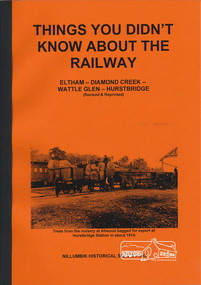
Book, Things You Didn't Know about the Railway: Eltham, Diamond Creek, Wattle Glen, Hurstbridge, 2017
... Update of 1st editon by Jock Ryan published in March 2003. 2nd edition (Revised) Nillumbik Historical Society December 2017 Brief history of the agitation and eventual extension and opening of the Hurstbridge Railway line from Eltham to Diamond Creek, Wattle Glen to Hurstbridge, which was opened in June 1912. ...Eltham District Historical Society Inc 728 Main Rd Eltham melbourne Update of 1st editon by Jock Ryan published in March 2003. 2nd edition (Revised) Nillumbik Historical Society December 2017 Brief history of the agitation and eventual extension and opening of the Hurstbridge Railway line from Eltham to Diamond Creek, Wattle Glen to Hurstbridge, which was opened in June 1912. ...Update of 1st editon by Jock Ryan published in March 2003. 2nd edition (Revised) Nillumbik Historical Society December 2017 Brief history of the agitation and eventual extension and opening of the Hurstbridge Railway line from Eltham to Diamond Creek, Wattle Glen to Hurstbridge, which was opened in June 1912. Includes details of events thereafter including Wattle Day and Railway accidents. Profusely illustrated with black and white photographs from the collection of the Nillumbik Historical Society (Diamond Creek). Agitation for a railway extension began in 1888 when a meeting was held at Arthurs Creek to press for the construction of a railway line from Heidelberg to Kinglake. The Chairman Mr Charles Draper said this was necessary because this was the best fruit growing district in Victoria. Mr Cameron M.P. pointed out that whatever route the line took it would have to follow the Diamond Valley from Eltham. At the same time another meeting was pressing for the line to be extended to Queenstown (St Andrews). However when detailed surveys were made it was discovered that the only possible route was to Hurstbridge because of the hills. In 1912 the railway was opened terminating at Hurstbridge. Bound with orange covers. Text with black and white illustrations. 30 pages.hurstbridge railway line,diamond creek,wattle glen,hurstbridge, nillumbik historical society -
 Eltham District Historical Society Inc
Photograph, Tess Justine (Nillumbik Shire Council), Murray's Bridge over the Diamond Creek, Eltham North, 19 Feb 2022
... The known facts are: • The railway line came to Eltham in 1902. • The extension of the railway from Eltham to Hurstbridge was constructed in 1912 so no railway line even existed through Murray's property until 1912 and the Victorian Railways maps at the time show no such siding on Murray’s property. • In 1923 a new company was formed in anticipation of the old Diamond Creek Gold Mine being re-opened. ...The known facts are: • The railway line came to Eltham in 1902. • The extension of the railway from Eltham to Hurstbridge was constructed in 1912 so no railway line even existed through Murray's property until 1912 and the Victorian Railways maps at the time show no such siding on Murray’s property. • In 1923 a new company was formed in anticipation of the old Diamond Creek Gold Mine being re-opened. ...Murray's Bridge over the Diamond Creek on the Diamond Creek Trail just prior to demolition and replacement with a new steel bridge. Heritage advice obtained by Nillumbik Shire Council, following a suggestion by the Eltham District Historical Society (EDHS), is that the original bridge appears to have been a simplified version of the Country Roads Board’s (CRB) standard timber bridge design of the early-to-mid 1920s. In c1990 Murray’s bridge was renovated with three recycled steel girders as part of a bike/pedestrian path in the reserve. During these alterations many parts of the bridge were removed, and some were replaced. Heritage advice indicates the condition of Murray’s bridge is poor. The remaining original parts are all in poor condition, with severe weathering, splitting and rot, especially to the stringers retained on the bridge. Heritage advice is that Murray’s Bridge does not have sufficient significance in the cultural history of the Nillumbik area to warrant inclusion in the Nillumbik Shire Heritage Overlay and also does not have sufficient significance as a rare survivor to warrant inclusion in the Nillumbik Shire Heritage Overlay. There are no indications in the historical record that this site was individually important to the cultural history of this area. EDHS is comfortable with the heritage advice provided to Council and has worked closely on this project with Council. EDHS has suggested some of the removed timbers be used in the vicinity of the bridge for landscaping and possibly seating, so as to retain these remnants close to the site of the original bridge, which is the last old timber bridge along the lower reaches of the Diamond Creek. Mary (Sweeney) Murray and John Wright Murray selected 80 acres, Lot C Section 16 and Lot 5 Section 17 Parish of Nillumbik, under an occupation license in 1866. John died in 1867 and freehold was granted to his son John in 1873. The farm was known as ‘Laurel Hill’. John Junior was an Eltham Shire councillor and sometime president from 1887 up until 1897. He added Lot A Section 16 to the farm in ca1888. John and his younger brother James arranged to rent/purchase Lot B Section 17, across Diamond Creek to the west, in ca1900. It appears that John and James farmed separately for a few years, with a new homestead built for James ad family on the high point of Lot B Section 17 in ca1910. John sold off Lot 5 Section 17 in 1912. When John died in 1912 James took over the land on both sides of the Diamond Creek. The old homestead on the west side of the Creek disappeared. A farm bridge over Diamond Creek from this period may have been located close to the northern boundary of the farm. John Langlands, owner of the farm known as ‘Ihurst’ on the west side of Diamond Creek to the south of the Murray’s land, died in 1907. In 1909 his land was then subdivided into 100 lots to become the ‘Glen Park Estate’. Other similar subdivisions of nineteenth century farms around Eltham in this period included the ‘Franktonia (or Beard’s) Estate’ to the northeast and ‘Bonsack’s Estate’ between Eltham and Greensborough. Soon after the opening of the railway extension line from Eltham to Hurstbridge in 1912, Glen Park and nearby residents including James Murray agitated for a railway station or siding to be located half-way between Eltham and Hurstbridge, so that the Glen Park residents who used the railway daily did not have to walk into the Eltham or Hurstbridge stations. Some believed Coleman’s Corner (opposite Edendale Farm) was an appropriate spot for the platform. James Murray was among those who thought the railway should be located on his land, closer to half-way between Eltham and Hurstbridge stations. The Railways Commissioners warned that the locals would have to fund these works themselves. The Glen Park Estate residents initially had difficulty accessing Eltham by road, with only an old low-level bridge over Diamond Creek at the south end of their estate. A new timber trestle bridge across the creek, now on Wattletree Road, was opened in 1915. Road access to the north was gained in 1927 when the new Murray’s Road, which crossed the Murray’s land, was built. Residents continued to agitate for a Glen Park station. By 1926 the Railways Commissioners’ preferred site was on the Murray’s land. They arranged an estimate of cost of a full-length platform. The estimate was too much for the locals, who in 1928 argued unsuccessfully for a shorter and hence cheaper platform. By 1929 Murray had agreed to donate the land, but the locals would still have to fund the works. Murray decided, unilaterally it would appear, to commence work on a timber trestle road bridge over Diamond Creek to link the new Murray Road to the proposed station. Late in 1929 he stopped work on the bridge, for reasons unknown, but started work again and completed the bridge in 1931. There is no further newspaper evidence of the campaign for the Glen Park station until 1939, when Murray and another local, Mr Maxwell, met the Railways Commissioner. The Glen Park locale now included 45 homes on the west side of the creek and 20 on the Eltham side. Most of the residents used the train every day. The Commissioner remained adamant that only a full-length platform could be built for safety reasons. It appears the campaign dissolved at this point. The increasing move to cars may have had an impact. There is no evidence of Murray’s bridge ever being connected to Murray’s Road, or of it having wide use for any purpose by locals. James Murray died in 1947 and the farm was taken over by his son James (Jim). Jim started to sell off parts of the farm in the 1980s, retaining a few acres around the ca1910 homestead and building a new house there. Recreation reserves were established along the creek. In ca1990 Murray’s bridge was renovated with steel girders as part of a bike/pedestrian path in the reserve. The old farmhouse was demolished in ca2014. * * * A theory posted on local community Facebook groups was that the bridge was built in the 1860s and was built to be more robust than was necessary for the movement of cows from one side of the creek to the other. It was suggested the robustness was necessary to support the weight of gold ore being transferred from a mine on Murray’s land to a railway siding near Murrays Bridge (presumably for transfer and processing at Diamond Creek). Perhaps this may have been one of the motivators for Murray, who really knows? Knowing when mining operations ceased on his land and how that fits the overall timeline would be useful but at the time the bridge was built, local gold production was minimal at best. The known facts are: • The railway line came to Eltham in 1902. • The extension of the railway from Eltham to Hurstbridge was constructed in 1912 so no railway line even existed through Murray's property until 1912 and the Victorian Railways maps at the time show no such siding on Murray’s property. • In 1923 a new company was formed in anticipation of the old Diamond Creek Gold Mine being re-opened. The mine had been previously closed and flooded. It was noted in the press at the time that the mine was within a mile of the railway. Nothing really came of this. • Construction of Murrays Bridge was commenced by James Murray in early 1929 in anticipation of a proposed flag station being nominated on his land, but work ceased shortly afterwards. The proposed flag station was commonly referred to as Glen Park as the residents of the Glen Park Estate wanted Option 1, located near them with the platform adjacent to Colemans corner. This was probably never going to fly as it was virtually in eyesight of Eltham station. Allandale Road was the third option, but the Commissioners' preferred option was No. 2 - on Murray's property. • The Railway Commissioners were not going to finance any such station and the works had to be funded by private landowners and residents, hence Murray investing in this himself. • Murray recommenced work two years later and finished his bridge in 1931 but unfortunately for him, the proposed flag station never eventuated. The bluestone siding you reference may well have been built by Murray as part of the proposed station platform. • Up until then, apart from the Main Road bridge, which was washed away in 1924, virtually all local crossings over the Diamond Creek were low lying bridges – Kaylocks Bridge at Brougham Street, Diamond Street bridge, Glen Park Road bridge. It is expected that Murray also had a low-lying bridge to connect his land either side of the creek. These were all washed away or severely damaged multiple times in the 1920s. Lessons were learnt, and Murrays Bridge appears to have been built in accordance with Country Road Board standards of the time. Flood damage was ongoing, and even more recently constructed raised bridges kept getting washed away, e.g., the new Wattle Tree Road bridge in 1958 just months after completion. Murray’s bridge was reinforced with steel some 30 years ago presumably to provide additional floodwater resistance, given the history of bridges disappearing in floodwaters. • In March 1932 it was reported in the Advertiser that there were still some prospectors operating around Eltham North who apart from further scarring the face of the earth over the previous two years had gained significant experience but little gold - hardly a driving factor for constructing a dedicated railway siding and bridge to transfer gold ore. It is far more probable that James Murray was hoping to have the railway station located on his property and invested his money by building the bridge to lead to it as well as a station platform. Had the station eventuated, it may well have driven up the value of his land for subdivision and new housing estates like the Glen Park Estate. That did not eventuate. Whilst the bridge was indeed old (90 years), the core structure being completed in 1931, it had been modified substantially from original and hence had no significant historic value – i.e., it was not a representative example of its type, construction, and age. Given that the bridge was not worthy of saving, the Eltham District Historical Society with Council’s support, and the Eltham Woodworkers group endeavoured to see what suitable sized timbers were salvageable to fabricate a commemorative seat. Unfortunately, the experts at the Woodworkers group were unable to salvage any suitable length/width timbers to fabricate the seat due to the presence of rot. Last remaining wooden trestle bridge on the Diamond Creek Trail just prior to demolition and replacementBorn digital image (27)diamond creek (creek), diamond creek trail, murrays bridge, ‘laurel hill’, john wright murray, mary (sweeney) murra, john murray jnr, james murray, john langlands, ‘ihurst’, ‘glen park estate’, beard's estate, franktonia, bonsack's estate, glen park estate, glen park railway station -
 Eltham District Historical Society Inc
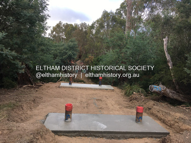
Photograph, Tess Justine (Nillumbik Shire Council), Construction work on replacement of Murray's Bridge over the Diamond Creek, Eltham North, 31 Mar 2022
... Eltham and Greensborough. Soon after the opening of the railway extension line from Eltham to Hurstbridge in 1912, Glen Park and nearby residents including James Murray agitated for a railway station or siding to be located half-way between Eltham and Hurstbridge, so that the Glen Park residents who used the railway daily did not have to walk into the Eltham or Hurstbridge stations. ...Eltham and Greensborough. Soon after the opening of the railway extension line from Eltham to Hurstbridge in 1912, Glen Park and nearby residents including James Murray agitated for a railway station or siding to be located half-way between Eltham and Hurstbridge, so that the Glen Park residents who used the railway daily did not have to walk into the Eltham or Hurstbridge stations. ...Construction work on replacement of Murray's Bridge over the Diamond Creek on the Diamond Creek Trail Mary (Sweeney) Murray and John Wright Murray selected 80 acres, Lot C Section 16 and Lot 5 Section 17 Parish of Nillumbik, under an occupation license in 1866. John died in 1867 and freehold was granted to his son John in 1873. The farm was known as ‘Laurel Hill’. John Junior was an Eltham Shire councillor and sometime president from 1887 up until 1897. He added Lot A Section 16 to the farm in ca1888. John and his younger brother James arranged to rent/purchase Lot B Section 17, across Diamond Creek to the west, in ca1900. It appears that John and James farmed separately for a few years, with a new homestead built for James ad family on the high point of Lot B Section 17 in ca1910. John sold off Lot 5 Section 17 in 1912. When John died in 1912 James took over the land on both sides of the Diamond Creek. The old homestead on the west side of the Creek disappeared. A farm bridge over Diamond Creek from this period may have been located close to the northern boundary of the farm. John Langlands, owner of the farm known as ‘Ihurst’ on the west side of Diamond Creek to the south of the Murray’s land, died in 1907. In 1909 his land was then subdivided into 100 lots to become the ‘Glen Park Estate’. Other similar subdivisions of nineteenth century farms around Eltham in this period included the ‘Franktonia (or Beard’s) Estate’ to the northeast and ‘Bonsack’s Estate’ between Eltham and Greensborough. Soon after the opening of the railway extension line from Eltham to Hurstbridge in 1912, Glen Park and nearby residents including James Murray agitated for a railway station or siding to be located half-way between Eltham and Hurstbridge, so that the Glen Park residents who used the railway daily did not have to walk into the Eltham or Hurstbridge stations. Some believed Coleman’s Corner (opposite Edendale Farm) was an appropriate spot for the platform. James Murray was among those who thought the railway should be located on his land, closer to half-way between Eltham and Hurstbridge stations. The Railways Commissioners warned that the locals would have to fund these works themselves. The Glen Park Estate residents initially had difficulty accessing Eltham by road, with only an old low-level bridge over Diamond Creek at the south end of their estate. A new timber trestle bridge across the creek, now on Wattletree Road, was opened in 1915. Road access to the north was gained in 1927 when the new Murray’s Road, which crossed the Murray’s land, was built. Residents continued to agitate for a Glen Park station. By 1926 the Railways Commissioners’ preferred site was on the Murray’s land. They arranged an estimate of cost of a full-length platform. The estimate was too much for the locals, who in 1928 argued unsuccessfully for a shorter and hence cheaper platform. By 1929 Murray had agreed to donate the land, but the locals would still have to fund the works. Murray decided, unilaterally it would appear, to commence work on a timber trestle road bridge over Diamond Creek to link the new Murray Road to the proposed station. Late in 1929 he stopped work on the bridge, for reasons unknown, but started work again and completed the bridge in 1931. There is no further newspaper evidence of the campaign for the Glen Park station until 1939, when Murray and another local, Mr Maxwell, met the Railways Commissioner. The Glen Park locale now included 45 homes on the west side of the creek and 20 on the Eltham side. Most of the residents used the train every day. The Commissioner remained adamant that only a full-length platform could be built for safety reasons. It appears the campaign dissolved at this point. The increasing move to cars may have had an impact. There is no evidence of Murray’s bridge ever being connected to Murray’s Road, or of it having wide use for any purpose by locals. James Murray died in 1947 and the farm was taken over by his son James (Jim). Jim started to sell off parts of the farm in the 1980s, retaining a few acres around the ca1910 homestead and building a new house there. Recreation reserves were established along the creek. In ca1990 Murray’s bridge was renovated with steel girders as part of a bike/pedestrian path in the reserve. The old farmhouse was demolished in ca2014. Born digital image (5)diamond creek (creek), diamond creek trail, murrays bridge, ‘laurel hill’, john wright murray, mary (sweeney) murra, john murray jnr, james murray, john langlands, ‘ihurst’, ‘glen park estate’, beard's estate, franktonia, bonsack's estate, glen park estate, glen park railway station -
 Eltham District Historical Society Inc
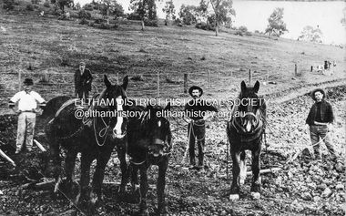
Photograph, Railway construction gang, possibly at Eltham North, c.1910
... Railway construction gang with horses possibly working on the Eltham to Hurstbridge line extension near Eltham North, c.1910...Eltham District Historical Society Inc 728 Main Rd Eltham melbourne Railway construction gang with horses possibly working on the Eltham to Hurstbridge line extension near Eltham North, c.1910 railways workers horses eltham north Butty Gang Construction gang Plough Railway construction Black and white print Railway construction gang, possibly at Eltham North Photograph Photograph ...Railway construction gang with horses possibly working on the Eltham to Hurstbridge line extension near Eltham North, c.1910Black and white printrailways, workers, horses, eltham north, butty gang, construction gang, plough, railway construction -
 Eltham District Historical Society Inc
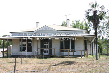
Photograph - Digital Photograph, Alan King, Edendale Farm Homestead, 29 January 2008
... Eltham bought it in 1970. Oddly Edendale was known as Mummery’s for almost 20 years, although Mummery owned it only for a short time.4 The shire used Edendale as a dog pound until amalgamation with other municipalities in 1996. The pound then moved to the Yan Yean Road, Plenty site, which had been used by the former Diamond Valley Shire Council. To the west and north the centre is bounded by Diamond Creek and on the east by the Melbourne-Hurstbridge railway line...Eltham bought it in 1970. Oddly Edendale was known as Mummery’s for almost 20 years, although Mummery owned it only for a short time.4 The shire used Edendale as a dog pound until amalgamation with other municipalities in 1996. The pound then moved to the Yan Yean Road, Plenty site, which had been used by the former Diamond Valley Shire Council. To the west and north the centre is bounded by Diamond Creek and on the east by the Melbourne-Hurstbridge railway line ...Edendale Farm is Nillumbik Shire Council's environment centre situated in Gastons Road, Eltham between the railway and the Diamond Creek. The homestead on the property was built in 1896 and is of historical significance, being the subject of a Heritage Overlay under the Nillumbik Planning Scheme. The Edendale property was originally part of an extensive land purchase in 1852 from the Crown by pioneer Eltham farmer Henry Stooke. He initially purchased 51 acres and later expanded his holdings by purchasing another three adjacent Crown allotments extending northerly from Josiah Holloway's Little Eltham subdivision. Despite clearing the land, Stooke did not build on this property, choosing to live on his property "Rosehill" at Lower Plenty. In 1896 Thomas Cool, Club Manager of the Victoria Coffee Palace in Melbourne purchased 7 acres of the original Stooke land and built the house now known as Edendale. Cool did not farm the land, instead using it as a gentleman’s residence, retiring to Eltham at weekends. In 1918 he purchased an additional 7 acres but in 1919 he sold the property. Later owners included J.W. Cox, the Gaston family and D. Mummery. In the 1980s the Eltham Shire Council purchased the site for use as a Council depot, but this use did not proceed. Subsequently, it was used as the Council pound. The Edendale Farm Pet Education and Retention Centre was established in the summer of 1988/1989 and was set up to replace the existing dog kennels with a high standard pet retention centre. The design style of the building was established to compliment the features of the existing house. It was equipped with 10 retention pens, a veterinary room and a pet education area where school children and other interested parties learnt about pet care procedures. It was later developed into a community farm and was run by an advisory committee and in 2000 it became an Environment Centre. In early 2006 an advisory committee was established for the development of a master plan for future development at Edendale Farm. The committee included Russell Yeoman, a former long-time shire planner and founding member of the Eltham District Historical Society. At the time of filming the Master Plan and future for Edendale was about continuing to develop Edendale as a centre of environment learning and looking at expanding displays and school program, running a lot more of life-long learning and workshops around sustainable living. Covered under Heritage Overlay, Nillumbik Planning Scheme. Published: Nillumbik Now and Then / Marguerite Marshall 2008; photographs Alan King with Marguerite Marshall.; p101 A sharp turn from busy Wattletree Road by the railway line, brings a surprise. Only 1.4 km from Eltham’s centre, sheep feed, blissfully unaware of the hectic suburban activity so close by. At the entrance to the 5.6ha Edendale Farm is another surprise. A work of art that looks like huge tree trunks transformed into bowler and top-hatted men. The Fences Act 1968 by Tony Trembath with Mark Cain and John Doyle, 1996, is classified by the National Trust of Australia as having Regional Significance. The title refers to a government act on disputes between neighbors over the placement of fences and boundaries. This takes a ‘wry swipe’ at a community divided by trivial squabbles. It also celebrates making do with limited resources.1 Further along on the left, the office wall is decorated with a massive Eltham Copper Butterfly, designed by Robert Tickner and made by school children with used plastic bottles and other waste material. Nillumbik Council runs Edendale as an Environmental Education Centre, to help preserve and enhance the local environment. As early as 1988 the former Eltham Shire Council realised Edendale’s importance in meeting people’s needs, particularly of children, to enjoy farmland. The centre, with the Eltham North Reserve to the north - including remnant bushland and open parkland - makes up the major part of the public open space for this area. The council considers this area will become increasingly important to the local community for recreational use.2 Educational programs aim to encourage community involvement to ensure the long-term rehabilitation and protection of natural bushland areas. Edendale is used by people of all ages - from school children to adults - for environmental programs and workshops, as well as for recreation, to enjoy the domestic animals and to picnic. Edendale is also home to the Environmental Works staff who manage reserves and roadsides and support Nillumbik Friends environmental groups. The Friends propagate plants at the nursery, which grows indigenous plants and sells these to the public.3 The centre demonstrates the sustainable living the farm teaches, with features like solar hot water and drive lighting and for the fireplace, logs of recycled cardboard. Edendale has had a varied history as a dog pound and even as a retreat for Thomas Cool, Club Manager of the Victoria Coffee Palace in Melbourne. His single-storey weatherboard house built in 1896, which still stands, was grander than most homes in Eltham. Although such buildings were common in many other parts of Melbourne, Eltham’s poverty and remoteness did not encourage such construction. The Victorian rectangular-shaped house, with a corrugated iron roof and veranda, has elegant large rooms, leadlight windows, ceiling roses, two bay windows and ornately carved wooden fireplace surrounds. Cool bought seven acres (2.8ha) from pioneer Eltham farmer Henry Stooke’s 200 acre (81ha) farm, which he had bought from the Crown in 1852. In 1918 Cool bought an extra seven acres (2.8ha) but in 1919 sold the estate to farmer John Cox. In 1933 Cox sold Edendale to Mrs Elizabeth Gaston, after whom the road leading to the centre was named. The property was owned by several Gaston family members, who called it Edendale, then by a police constable, Douglas Mummery, until the Shire of Eltham bought it in 1970. Oddly Edendale was known as Mummery’s for almost 20 years, although Mummery owned it only for a short time.4 The shire used Edendale as a dog pound until amalgamation with other municipalities in 1996. The pound then moved to the Yan Yean Road, Plenty site, which had been used by the former Diamond Valley Shire Council. To the west and north the centre is bounded by Diamond Creek and on the east by the Melbourne-Hurstbridge railway line. Part of the Research creek forms the centre’s southern boundary.This collection of almost 130 photos about places and people within the Shire of Nillumbik, an urban and rural municipality in Melbourne's north, contributes to an understanding of the history of the Shire. Published in 2008 immediately prior to the Black Saturday bushfires of February 7, 2009, it documents sites that were impacted, and in some cases destroyed by the fires. It includes photographs taken especially for the publication, creating a unique time capsule representing the Shire in the early 21st century. It remains the most recent comprehenesive publication devoted to the Shire's history connecting local residents to the past. nillumbik now and then (marshall-king) collection, edendale farm -
 Eltham District Historical Society Inc
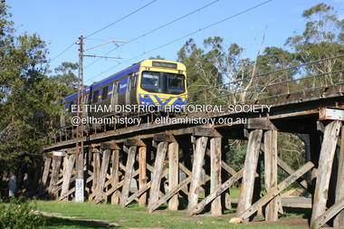
Photograph - Digital Photograph, Alan King, Eltham Railway Trestle Bridge, 28 December 2007
... Eltham railway trestle bridge is the only one of its kind still regularly used in Melbourne’s metropolitan railway network. Opened in 1902, it is also one of Victoria’s very few timber rail bridges that still carries trains.1 The bridge is part of the railway line extension from Heidelberg - extended to Hurstbridge in 1912. ...Eltham melbourne Covered under National Trust of Australia (Victoria) State Significance and Heritage Overlay, Nillumbik Planning Scheme. Published: Nillumbik Now and Then / Marguerite Marshall 2008; photographs Alan King with Marguerite Marshall.; p103 The Eltham railway trestle bridge is the only one of its kind still regularly used in Melbourne’s metropolitan railway network. Opened in 1902, it is also one of Victoria’s very few timber rail bridges that still carries trains.1 The bridge is part of the railway line extension from Heidelberg - extended to Hurstbridge ...Covered under National Trust of Australia (Victoria) State Significance and Heritage Overlay, Nillumbik Planning Scheme. Published: Nillumbik Now and Then / Marguerite Marshall 2008; photographs Alan King with Marguerite Marshall.; p103 The Eltham railway trestle bridge is the only one of its kind still regularly used in Melbourne’s metropolitan railway network. Opened in 1902, it is also one of Victoria’s very few timber rail bridges that still carries trains.1 The bridge is part of the railway line extension from Heidelberg - extended to Hurstbridge in 1912. This extension resulted in one of the greatest social changes experienced in Eltham Shire, as it considerably lessened its isolation attracting tourists, artists and suburban commuters particularly after World War Two.2 The bridge has been classified by the National Trust as historically, scientifically, aesthetically and socially significant at state level. But this has not always been recognised, and in 1977, locals fought to save it from destruction. The Victorian Railways proposed to replace the bridge with an earth embankment and large culverts to avoid maintenance problems and fire. This was rejected by the Eltham Council who protested that the bridge helped maintain the area’s rural character, historic link and beauty, as well as avoiding possible serious flooding on the flood plain if a culvert was blocked. The bridge stands as part of a National Trust classified landscape which includes the Alistair Knox Park, named after the local conservationist and architect who helped to make Eltham famous for its mud-brick houses. The landscape includes tall and spreading manna gums and candlebarks, and the historic Shillinglaw Cottage. Artist Walter Withers, one of the Heidelberg School of painters, painted the bridge early in the 20th century. The 38 span single-track railway bridge over creek and road has 34 timber-beam spans and four steel-joist spans, supported by four-pile timber piers and timber abutments. It has almost 200m of timber deck. All of the timbers have been replaced over the years, but the only change to the bridge’s character was the addition of pylons and wiring for electric trains in 1923. A petition for a railway to the shire was first made in 1883. A large deputation of local citizens to the Commissioner of Railways proposed a route passing through Alphington to midway between Greensborough and Eltham up the Diamond Creek valley towards Queenstown and Kinglake. As a result the Princes Bridge-Heidelberg Railway was opened in 1888. From 1888 locals demanded a railway extension. Kangaroo Ground farmers in particular, led by Shire Councillor and Member for Evelyn, Ewen Cameron, said it would assist local farmers and orchardists send their produce to the Melbourne market. In 1890, before the severe economic Depression, an extension of the line to Hurst’s Bridge (now Hurstbridge) was included in a new Railways Bill. The parliamentary delegations were regaled with a banquet at Hurst’s barn and entertained by the Diamond Creek Brass Band, but the extension was abandoned when the Depression struck in 1892-1893. The extension of the railway to Eltham, completed in 1902, was one of the few built in those hard times. That is why the Eltham timber-trestle railway bridge is a rare example of a broad-gauge rail bridge constructed between 1893 and 1910. At the opening, despite persistent drizzle, 300 children waving flags and banners were among the large crowd welcoming the first train, carrying official dignitaries, to Eltham. It had taken 24 years to bring the railway to Eltham. From then Eltham became a popular destination for outings. Mr Orford of Eltham recalled that after the railway came to Eltham ‘the craze for picnics on weekends and holidays began…. During the wattle season, wattle trains came to Eltham frequently. The visitors roamed the creek pulling great armfuls of wattle blossom to take back with them to Melbourne’.3 In 1926 the railway line was electrified as part of the metropolitan rail network. But the Victorian Railways decided not to complete the formerly planned Diamond Valley Railway to Queenstown (now St Andrews) and Kinglake.This collection of almost 130 photos about places and people within the Shire of Nillumbik, an urban and rural municipality in Melbourne's north, contributes to an understanding of the history of the Shire. Published in 2008 immediately prior to the Black Saturday bushfires of February 7, 2009, it documents sites that were impacted, and in some cases destroyed by the fires. It includes photographs taken especially for the publication, creating a unique time capsule representing the Shire in the early 21st century. It remains the most recent comprehenesive publication devoted to the Shire's history connecting local residents to the past. nillumbik now and then (marshall-king) collection, eltham railway trestle bridge, eltham trestle bridge -
 Greensborough Historical Society
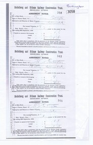
Receipt (copy), Heidelberg and Eltham Railway Construction Trust, Heidelberg and Eltham Railway Construction Trust: Assessment Notice, 1916
... heidelberg and eltham railway construction trust...hurstbridge rail line...Eltham Railway Construction Trust, 1916. Owners are Benjamin Partington and William Partington. william james partington benjamin partington heidelberg and eltham railway construction trust hurstbridge rail line Copy of receipts Heidelberg and Eltham Railway Construction Trust: Assessment Notice Receipt (copy) Heidelberg and Eltham Railway Construction Trust ...Receipts for rates payable to the Heidelberg and Eltham Railway Construction Trust, 1916. Owners are Benjamin Partington and William Partington.Copy of receiptswilliam james partington, benjamin partington, heidelberg and eltham railway construction trust, hurstbridge rail line -
 Greensborough Historical Society
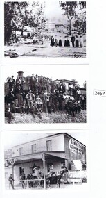
Postcards, Yarra Plenty Regional Library, Eltham District Historical Society postcards, 1900s
... Eltham c. 1902. 2. Main Road Hurstbridge. 3. Railway workers celebrate the first steam train to Hurstbridge 1912 watson's hotel, eltham hurstbridge hurstbridge train line eltham district historical society Three black & white postcards Eltham District Historical Society postcards Postcards Yarra Plenty Regional Library Eltham District Historical Society ...1. Watson's Hotel, cnr. Pitt Street and Main Road Eltham c. 1902. 2. Main Road Hurstbridge. 3. Railway workers celebrate the first steam train to Hurstbridge 1912Three black & white postcardswatson's hotel, eltham, hurstbridge, hurstbridge train line, eltham district historical society -
 Greensborough Historical Society
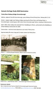
Document - Submission, Norm Colvin et al, Banyule Heritage Study 2020 Nominations - Plenty River railway bridge Greensborough, 2020
... Greensborough Historical Society 34A Glenauburn Road Lower Plenty Lower Plenty melbourne Part of the single track railway extension of 1902 from Heidelberg to Eltham, the Plenty River railway bridge Greensborough, was nominated for the Banyule Heritage Study 2020. This nomination was prepared by Norm Colvin & Anne Paul on behalf of the Greensborough Historical Society hurstbridge rail line plenty river banyule heritage study 2020 1 p. ...Part of the single track railway extension of 1902 from Heidelberg to Eltham, the Plenty River railway bridge Greensborough, was nominated for the Banyule Heritage Study 2020. This nomination was prepared by Norm Colvin & Anne Paul on behalf of the Greensborough Historical Society1 p. Text and photographshurstbridge rail line, plenty river, banyule heritage study 2020 -
 Greensborough Historical Society
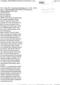
Newspaper Clipping (copy), Greensborough's red letter days; railway opening, by D. Medhurst, 13/04/1933
... Greensborough Historical Society 34A Glenauburn Road Lower Plenty Lower Plenty melbourne Account of the background to the construction of the extension of the railway line between Heidelberg and Eltham, and the effects of the railway service on the Greensborough, Briar Hill and Montmorency areas. railways hurstbridge rail line 3 p. ...Account of the background to the construction of the extension of the railway line between Heidelberg and Eltham, and the effects of the railway service on the Greensborough, Briar Hill and Montmorency areas.3 p. OCR transcript of original article (copied from Trove)railways, hurstbridge rail line -
 Greensborough Historical Society
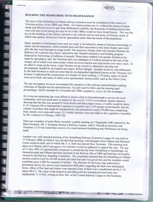
Folder, Peter Simmenauer, Building the Heidelberg to Eltham railway, by Peter Simmenauer, 2018
... Greensborough Historical Society 34A Glenauburn Road Lower Plenty Lower Plenty melbourne Background to the construction of the Heidelberg to Eltham railway extension, completed May 1902, written and collated by Peter Simmenauer railways hurstbridge rail line heidelberg station eltham station Folder containing 4 p. article, copies of newspaper articles and contemporary documents and photographs Building the Heidelberg to Eltham railway, by Peter Simmenauer Folder Peter Simmenauer ...Background to the construction of the Heidelberg to Eltham railway extension, completed May 1902, written and collated by Peter SimmenauerFolder containing 4 p. article, copies of newspaper articles and contemporary documents and photographsrailways, hurstbridge rail line, heidelberg station, eltham station -
 Greensborough Historical Society
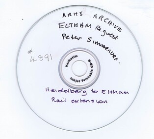
CD-ROM, Australian Railways Historical Society, Heidelberg to Eltham Railway: ARHS Archive, 30/01/2018
... Greensborough Historical Society 34A Glenauburn Road Lower Plenty Lower Plenty melbourne Report by Australian Railways Historical Society in response to a request for information on the Heidelberg to Eltham railway extension by Peter Simmenauer railways hurstbridge rail line ARHS Archive: Eltham Request CD-Rom in plastic case Heidelberg to Eltham Railway: ARHS Archive CD-ROM Australian Railways Historical Society ...Report by Australian Railways Historical Society in response to a request for information on the Heidelberg to Eltham railway extension by Peter SimmenauerCD-Rom in plastic caseARHS Archive: Eltham Requestrailways, hurstbridge rail line -
 Greensborough Historical Society
Newspaper Clipping, Eltham Railway: loan, deviation and compensation, 21/05/1900
... Greensborough Historical Society 34A Glenauburn Road Lower Plenty Lower Plenty melbourne Relates to the disagreement between advocates of the original surveyed route and the proposed "deviation" for the Heidelberg to Eltham railway extension, 1900. railways hurstbridge rail line 6 p. transcripts of newspaper reports from the Age 21/05/1900 and Mercury and Weekly Courier 13/07/1900 regarding discussions on the route to be taken by the Heidelberg to Eltham railway extension Eltham Railway: loan, deviation and compensation Newspaper Clipping The Age Mercury and Weekly Courier ...Relates to the disagreement between advocates of the original surveyed route and the proposed "deviation" for the Heidelberg to Eltham railway extension, 1900.6 p. transcripts of newspaper reports from the Age 21/05/1900 and Mercury and Weekly Courier 13/07/1900 regarding discussions on the route to be taken by the Heidelberg to Eltham railway extensionrailways, hurstbridge rail line -
 Eltham District Historical Society Inc
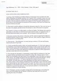
Folder, Hurstbridge Line Upgrade, 2010
... railway line construction...hurstbridge line...hurstbridge railway line...eltham... line construction hurstbridge line hurstbridge railway line eltham railway station eltham station carpark train stabling yard HG Folders 108 and 115 23 documents, 62 pages of news clippings, photocopies and colour political fliers Hurstbridge Line Upgrade Folder ...Correspondence and information from the State Government about the Hurstbridge Line upgrade 2010. Also includes newspaper articles, Nillumbik Shire Council minutes report, map and contextual information regarding the Eltham Major Activity Centre structure Plan 2009. The main area of concern was the plan to reconfigue the Eltham stabling yard.23 documents, 62 pages of news clippings, photocopies and colour political fliersHG Folders 108 and 115harry gilham collection, railway line construction, hurstbridge line, hurstbridge railway line, eltham railway station, eltham station carpark, train stabling yard -
 Eltham District Historical Society Inc
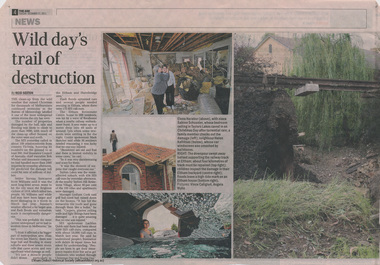
Booklet - Newspaper articles, Christmas Day Storm, 2011
... Eltham and Hurstbridge areas. The storm caused destablisation of parts of the Hurstbridge railway line. ...Eltham and Hurstbridge areas. The storm caused destablisation of parts of the Hurstbridge railway line. ...A severe storm with damaging hail, rain and flooding impacted Melbourne on 25 December 2011 with particular damage to Eltham and Hurstbridge areas. The storm caused destablisation of parts of the Hurstbridge railway line. Wild day's trail of destruction, by Reid sexton, The Age, Tuesday, December 21, 2011, p4 Storm toll sparks rail safety fear, Reid Saxton, The Age, Tuesday, December 21, 2011, p52 newspaper articlesstorm, floods, flooding, christmas day, hurstbridge railway line -
 Eltham District Historical Society Inc
Folder, The Age et al, Centenary of the Eltham to Hurstbridge Railway extension, 2012
... hurstbridge railway line...centenary celebrations...eltham...In 2012 local community groups acknowledged the centenary of the extension of the Railway line from Eltham to Hurstbridge which took place in 1912. ...Eltham District Historical Society Inc 728 Main Rd Eltham melbourne In 2012 local community groups acknowledged the centenary of the extension of the Railway line from Eltham to Hurstbridge which took place in 1912. ...In 2012 local community groups acknowledged the centenary of the extension of the Railway line from Eltham to Hurstbridge which took place in 1912. Newspaper article: Automatic system signals the end of the station's tradition, The Age 20 June 2012. Material produced by Nillumbik Historical Society advertising centenary celebrations and providing history with photographs of the Eltham to Hurstbridge extension. The Heidelberg Historian newsletter of the Heidelberg Historical Society No 279, December 2013 (14 pages) including an article by David Watson "Prince's Bridge to Hurst's Bridge".29 pages, newspaper articleharry gilham collection, hurstbridge railway line, centenary celebrations, eltham railway station -
 Eltham District Historical Society Inc
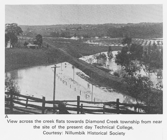
Work on paper (Sub-Item) - Photograph, View across the creek flats towards Diamond Creek township
... Eltham District Historical Society Inc 728 Main Rd Eltham melbourne Undated black and white photograph of view across the creek flats towards Diamond Creek township showing the railway line, with the Diamond Creek under flood. Situated behind the vicinity of Diamond Valley College, Main Hurstbridge ...Undated black and white photograph of view across the creek flats towards Diamond Creek township showing the railway line, with the Diamond Creek under flood. Situated behind the vicinity of Diamond Valley College, Main Hurstbridge Road, Diamond Creek. Diamond Valley College was formed in 1989 from the almagamation of Diamond Creek Technical School and Hurstbridge High School. Nillumbik Historical Society collectionflood, diamond creek, nillumbik historical society