Showing 2 items matching "elwood pier"
-
 Bayside Gallery - Bayside City Council Art & Heritage Collection
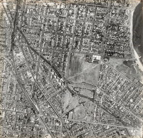
Photograph, Department of Crown Lands and Survey, Victoria, Brighton, Elwood and Elsternwick, c. 1965-71
... ...Elwood Pier...A small section of the Bay around Elwood Pier is on the upper right edge of the photograph. ...A small section of the Bay around Elwood Pier is on the upper right edge of the photograph. ...The Department of Crown Lands and Survey (1857-1983) was responsible for the administration of survey and mapping and the sale, occupation and management of crown land throughout its existence. This aerial photograph shows parts of Brighton, Elwood and Elsternwick and was taken circa 1965-71.brighton, department of crown lands and survey, aerial photograph, bayside, port phillip bay, map, cartographic material, elwood, elsternwick, elsternwick park, elwood tram depot, elwood pier, new street, glen huntly road, st kilda street, nepean highway -
 St Kilda Historical Society
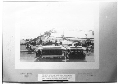
Photograph, Wall Bros, Foreshore Reclamation work, c. 1905
... The first foreshore reclamation work between the pier and the royal St Kilda Yacht Club, taken from the Esplanade Hotel about 1905. Wall Bros., 15 Chapel St, St Kilda. D.J. Taggart 58 Glenhuntly Road, Elwood...St Kilda Historical Society St Kilda Branch Library 150 Carlisle Street St Kilda melbourne Between pier and St Kilda Yacht Club, taken from Esplanade Hotel, c1905 The first foreshore reclamation work between the pier and the royal St Kilda Yacht Club, taken from the Esplanade Hotel about 1905. Wall Bros., 15 Chapel St, St Kilda. D.J. Taggart 58 Glenhuntly Road, Elwood ...Between pier and St Kilda Yacht Club, taken from Esplanade Hotel, c1905black and white photograph, unmounted copy, fair conditionThe first foreshore reclamation work between the pier and the royal St Kilda Yacht Club, taken from the Esplanade Hotel about 1905. Wall Bros., 15 Chapel St, St Kilda. D.J. Taggart 58 Glenhuntly Road, Elwood 3184.