Showing 4 items matching "emergency management north east victoria"
-
 Wodonga & District Historical Society Inc
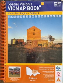
Book - Spatial Vision's VICMAP BOOK 2014 - North East Region
... Emergency Management North East Victoria...Emergency Management North East Victoria CFA Wodonga This edition of Spatial Vision's VicMap Book North East Region was published in May 2014 and provides detailed topographic maps for the region. ...This edition of Spatial Vision's VicMap Book North East Region was published in May 2014 and provides detailed topographic maps for the region. It was used by emergency services and various agencies, including the Country Fire Authority (CFA). It covers areas including Wodonga, Albury, Wangaratta, and beyond, including national parks and recreation areas. Text on the cover states that the volume is "Trusted by and produced in partnership with: Department of Environment, Land, Water & Planning, Country Fire Authority, State Emergency Service, Parks Victoria, Victoria Police".A spiral bound volume of 409 pages including colour topographic maps and illustrations of North East Victoria. The cover features a colour photo of the old flour mill at Milawa, Victoria. It also features an index map inside the front cover, a legend, road index, and locality index.non-fictionThis edition of Spatial Vision's VicMap Book North East Region was published in May 2014 and provides detailed topographic maps for the region. It was used by emergency services and various agencies, including the Country Fire Authority (CFA). It covers areas including Wodonga, Albury, Wangaratta, and beyond, including national parks and recreation areas. Text on the cover states that the volume is "Trusted by and produced in partnership with: Department of Environment, Land, Water & Planning, Country Fire Authority, State Emergency Service, Parks Victoria, Victoria Police".emergency management north east victoria, cfa wodonga -
 Wodonga & District Historical Society Inc
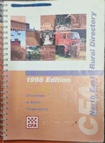
Book - North East Rural Directory 1998
... Emergency Management North East Victoria...Emergency Management North East Victoria CFA Region 24 CFA Wodonga CFA Region 23 The CFA North East Rural Directory for Regions 23 and 24 was designed to assist fire brigades and other emergency services in responding to calls in the North East region of Victoria. ...The CFA North East Rural Directory for Regions 23 and 24 was designed to assist fire brigades and other emergency services in responding to calls in the North East region of Victoria. Its purpose was to minimize response times to emergency situations by providing accurate and detailed information about all of the localities in the regions. District 23 is based at Wangaratta and Extends as far south as Woods Point. District 24 is centred in Wodonga and extends past Corryong to the New South Wales border following the Murray River. It also includes Falls Creek and Mount Hotham.A spiral bound volume including colour topographic maps and illustrations of North East Victoria. The cover features a collage of colour photo of North East Victoria including a CFA firefighter in a truck with members of his family beside it. The book also features a key map, explanation of map references and symbols, localities index. Alphabetical road indexes for Wodonga, Albury, Wangaratta and Benalla as well as township maps and alphabetical road indexes for smaller communities are included.The CFA North East Rural Directory for Regions 23 and 24 was designed to assist fire brigades and other emergency services in responding to calls in the North East region of Victoria. Its purpose was to minimize response times to emergency situations by providing accurate and detailed information about all of the localities in the regions. District 23 is based at Wangaratta and Extends as far south as Woods Point. District 24 is centred in Wodonga and extends past Corryong to the New South Wales border following the Murray River. It also includes Falls Creek and Mount Hotham.emergency management north east victoria, cfa region 24, cfa wodonga, cfa region 23 -
 Wodonga & District Historical Society Inc
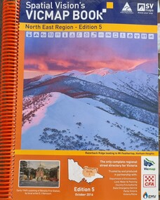
Book - Spatial Vision's VICMAP BOOK 2016 - Northeast Region, Spatial Vision Innovations Pty Ltd, 2016
... Emergency Management North East Victoria...Emergency Management North East Victoria State Emergency Service CFA Wodonga This edition of Spatial Vision's VicMap Book North East Region was published in October 2016 and provides detailed topographic maps for the region. ...This edition of Spatial Vision's VicMap Book North East Region was published in October 2016 and provides detailed topographic maps for the region. It was used by emergency services and various agencies, including the Country Fire Authority (CFA). It covers areas including Wodonga, Albury, Wangaratta, and beyond, including national parks and recreation areas. Text on the cover states that the volume is "Trusted by and produced in partnership with: Department of Environment, Land, Water & Planning, Country Fire Authority, State Emergency Service, Parks Victoria, Victoria Police".A spiral bound volume of 409 pages including colour topographic maps and illustrations of North East Victoria. The cover features a colour photo of Razorback Ridge leading to Mount Feathertop, Hotham Heights, Victoria. It also features an index map inside the front cover, a legend, road index, and locality index.This edition of Spatial Vision's VicMap Book North East Region was published in October 2016 and provides detailed topographic maps for the region. It was used by emergency services and various agencies, including the Country Fire Authority (CFA). It covers areas including Wodonga, Albury, Wangaratta, and beyond, including national parks and recreation areas. Text on the cover states that the volume is "Trusted by and produced in partnership with: Department of Environment, Land, Water & Planning, Country Fire Authority, State Emergency Service, Parks Victoria, Victoria Police".emergency management north east victoria, state emergency service, cfa wodonga -
 Ringwood and District Historical Society
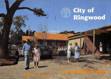
Booklet, City of Ringwood 1985 Information Guide, 1985
... East Ringwood Shopping Centre 22 Emergency Telephone Nos. 63 Garbage Collection 20 Golf Course 15 Health 26 Historical Research Croup 47 Home Help 30 Hospitals 48 Immunisations 27 Incinerators 21 Infant Welfare Centres49 J.P.'s and Commissioners 37 Library 28 & 29 Lionsbrae 17 Management Executive 11 Mayoral Message – Cr. R. Gardini, J.P. 3 Meals on Wheels 34 North Ringwood Senior Citizens 16 Opportunity Shops 53 Parks and Reserves 53 Parliamentary Representatives 9 Playgroups 55 Pre-schools 56 Public Toilets 56 Rates 25 Ringwood Croydon Advisory Service 37 Schools 58 Senior Citizens Centres 60 Swimming Pool 14 Unemployment 62 Victoria's 150th Anniversary 36 Works Programme 18 & 19 Youth Outreach Worker 62 ...East Ringwood Shopping Centre 22 Emergency Telephone Nos. 63 Garbage Collection 20 Golf Course 15 Health 26 Historical Research Croup 47 Home Help 30 Hospitals 48 Immunisations 27 Incinerators 21 Infant Welfare Centres49 J.P.'s and Commissioners 37 Library 28 & 29 Lionsbrae 17 Management Executive 11 Mayoral Message – Cr. R. Gardini, J.P. 3 Meals on Wheels 34 North Ringwood Senior Citizens 16 Opportunity Shops 53 Parks and Reserves 53 Parliamentary Representatives 9 Playgroups 55 Pre-schools 56 Public Toilets 56 Rates 25 Ringwood Croydon Advisory Service 37 Schools 58 Senior Citizens Centres 60 Swimming Pool 14 Unemployment 62 Victoria's 150th Anniversary 36 Works Programme 18 & 19 Youth Outreach Worker 62 Community information booklet issued by City of Ringwood for 1985 - covering the facilities and activities of the Ringwood Council and other local organisations and associations. ...Community information booklet issued by City of Ringwood for 1985 - covering the facilities and activities of the Ringwood Council and other local organisations and associations. Cover photograph: Lionsbrae - Frail Aged Hostel.CONTENTS: (page no.) By-Laws/Traffic Regs. 35 Chief Executive 10 Children's Service 12, 13 & 40 Churches 41 City Map 32 & 33 Committees of Council 7 Community Services 38 Community Services Officer 43 Council Finances 24 Councillors 4 & 5 Council Meeting Dates 6 Council Representatives 8 Cultural Centre 23 Disabled Persons Facilities 44 Eastern Corridor 18 East Ringwood Shopping Centre 22 Emergency Telephone Nos. 63 Garbage Collection 20 Golf Course 15 Health 26 Historical Research Croup 47 Home Help 30 Hospitals 48 Immunisations 27 Incinerators 21 Infant Welfare Centres49 J.P.'s and Commissioners 37 Library 28 & 29 Lionsbrae 17 Management Executive 11 Mayoral Message – Cr. R. Gardini, J.P. 3 Meals on Wheels 34 North Ringwood Senior Citizens 16 Opportunity Shops 53 Parks and Reserves 53 Parliamentary Representatives 9 Playgroups 55 Pre-schools 56 Public Toilets 56 Rates 25 Ringwood Croydon Advisory Service 37 Schools 58 Senior Citizens Centres 60 Swimming Pool 14 Unemployment 62 Victoria's 150th Anniversary 36 Works Programme 18 & 19 Youth Outreach Worker 62 rinx