Showing 6 items matching "emergency navigation"
-
 Flagstaff Hill Maritime Museum and Village
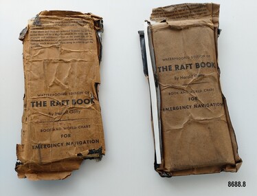
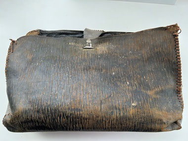
Booklet - Book and World Chart for Emergency Navigation, George Grady Press, The Raft Book, 1943
... Book and World Chart for Emergency Navigation...Book and World Chart for Emergency Navigation...The original book was 152 pages long however a condensed version was made which consisted of a 64 page booklet, combined map and star chart and calendar strip enclosed in a waterproof slipcase, to be placed in life rafts for emergency use. The booklet included navigational advice and ideas such as ocean currents, estimation of distance, using a compass, measurement of angles, recognising and steering by the stars, land indications from sea birds, migration of sea birds and insects, sounds from the land, the scent of the land and ocean currents and the colour of the sea etc. ...Front of package - "WATERPROOFED EDITION OF/ THE RAFT BOOK / By Harold Gatty / BOOK AND WORLD CHART / FOR / EMERGENCY NAVIGATION / To open envelope tear along above line. ...The Raft Book Booklet Book and World Chart for Emergency Navigation George Grady Press Harold and Fenna Gatty ...Harold Gatty was born on January 5th, 1903 in Campbell Town, Tasmania. He was a navigator and aviation pioneer. He began his career learning navigation at the age of 14 as a midshipman at the Royal Australian Naval College but withdrew after three years and became an apprenticed ship's officer with the Patrick Steamship Company of Sydney. After W. W. 1 he joined the Australian Merchant Navy where he learned the constellations while standing night watch and became an expert in celestial navigation while serving on many ships sailing between Australia and California. In 1927 he moved to California and opened a navigation school and also a laboratory repairing navigational equipment. At this time he became very interested in air navigation and was aware of the limitations of existing methods and instruments for aerial navigation. He began researching ways of improving aerial navigation. Two early inventions of his were his air sextant and a ground speed and drift indicator which formed the basis of the automatic pilot which later came to be standard equipment on most aircraft. He worked with several record breaking pilots including Ann Morrow Lindbergh (who went on to serve as a navigator for her husband Charles Lindbergh), helped Wiley Post break the world record circumnavigating the Earth, invented a new method of "dead reckoning" that revolutionised the ability to fly safely through cloudy conditions without drifting off course and famously navigated a small plane (whilst trying to cross the Pacific) over 1900 km through fog (with no radio) and using only his dead reckoning techniques, back to their starting point in Japan after they developed fuel problems. In 1932 Gatty received the Distinguished Flying Cross from President Hoover. In 1934 Gatty formed the South Seas Commercial Company with Donald Douglas with the aim to deliver air services to the islands of the South Pacific. The Company was sold to Pan Am but he continued to work for them. In 1935 he went on a sailing expedition investigating several small islands in the South Pacific and was briefly marooned on Baker Island. He was able to use his extensive knowledge of seabird habits to save the crew. He was also very interested in the ability of the Polynesians to navigate using the stars. During the Second World War Gatty was given the honorary rank of Group Captain in the Royal Australian Air Force (RAAF) and worked for the U. S. Army Air Forces (USAAF) in the South Pacific. In 1943 he moved to Washington where he developed a survival book (The Raft Book) specifically for boat crews or air crews flying over the Pacific to help them survive and navigate their life rafts in remote areas of the ocean. The original book was 152 pages long however a condensed version was made which consisted of a 64 page booklet, combined map and star chart and calendar strip enclosed in a waterproof slipcase, to be placed in life rafts for emergency use. The booklet included navigational advice and ideas such as ocean currents, estimation of distance, using a compass, measurement of angles, recognising and steering by the stars, land indications from sea birds, migration of sea birds and insects, sounds from the land, the scent of the land and ocean currents and the colour of the sea etc. After W.W.2 Gatty moved to Fiji and formed Fiji Airways (which later became Air Pacific). Harold Gatty died in August 1957.The two copies of "The Raft Book" are significant as they are a written summary of the many methods of sea navigation (both modern and historical) that existed in the 1940's. They are also a record of Harold Gatty, who played a significant role in the development of modern day aerial navigation using his understanding of different sea navigational techniques.Two rectangular brown packets with waterproof coverings (oiled paper) titled "The Raft Book" by Harold Gatty. Each packet contains a folded 64 page paper booklet with detailed instructions for navigating a small craft in open seas, a folded chart (with a map of the world and oceans, well known constellations, latitude and longitude charts, Greenwich time and a scale for string lengths and Harp scale) and a long folded paper calendar strip.Front of package - "WATERPROOFED EDITION OF/ THE RAFT BOOK / By Harold Gatty / BOOK AND WORLD CHART / FOR / EMERGENCY NAVIGATION / To open envelope tear along above line. If the envelope is used again fold the flap to keep contents dry. 1. This envelope contains a book, chart and tape for emergency navigation. The contents are folded to take up the least possible space and therefore should not be removed until needed. 2. if the chart and tape are immersed in water for a long period, there will be a slight variation in the scale but the strength and resistence to tear of the paper will not be changed. In the event of long immersion, dry the chart and tape as much as possible before using in order to in order to get the greatest accuracy in scale. Front of booklet - THE RAFT BOOK / LORE OF THE SEA AND SKY /By Harold Gatty IMPORTANT FOR YOUR SECURITY/Upon abandoning ship you may have to be your own navigator. Take the following pre/cautions for your own safety:/ Carry a good type of pocket watch / keep it wound and have it running on Greenwich (England) / Time, which you can get from the navigating officer. / Keep track of the date at Greenwich; and on a 24-hour basis, / know whether the time is, say, 6 hours (6 A.M.) showing on / your watch, or 18 hours (6P.M.) Greenwich. / PROECT YOUR WATCH. GET A RUBBER SACK FOR IT (OBTAIN FROM PHARMACIST) AND KEEP IT DRY / KEEP A PENCIL IN YOUR POCKET/ POSITION OF SHIP WHEN ABANDONED PRINTED IN UNITED STATES OF AMERICA GEORGE GRADY PRESS, NEW YORK/COPYRIGHT, 1943, BY HAROLD AND FENNA GATTYflagstaff hill maritime museum and village, shipwreck coast, warrnambool, the raft book, harold gatty, book and world chart for emergency navigation, ww 2, ww ii, navigation, air navigation, aerial navigation, lindbergh, wiley post, dead reckoning, south seas commercial company, u.s. army airforce, usaaf, survival book, life rafts, sea navigation, emergency navigation, fiji airways, harp scale -
 Orbost & District Historical Society
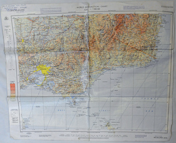
map, 1985
... Using these charts and other tools, pilots are able to determine their position, safe altitude, best route to a destination, navigation aids along the way, alternative landing areas in case of an in-flight emergency, and other useful information such as radio frequencies and airspace boundaries. ...Using these charts and other tools, pilots are able to determine their position, safe altitude, best route to a destination, navigation aids along the way, alternative landing areas in case of an in-flight emergency, and other useful information such as radio frequencies and airspace boundaries. ...An aeronautical chart is a map designed to assist in navigation of aircraft. Using these charts and other tools, pilots are able to determine their position, safe altitude, best route to a destination, navigation aids along the way, alternative landing areas in case of an in-flight emergency, and other useful information such as radio frequencies and airspace boundaries. World aeronautical charts have a scale of 1:1,000,000 and cover relatively large areas. Orbost Aero Club began in 1969 with Basil Dowie as Chair, David Nixon as Secretary/Treasurer. The group went into recess from 1977-1991 closing in 1997. The mid 1960s were boom years in flying training in Australia and the number of Aero Clubs grew rapidly. The Club played a significant role in the establishment of the small airport at Marlo and in the ongoing operation and development of the airport over the years particularly for patient transfer by aerial ambulance. The Orbost Aero Club Club played a significant role in the establishment of the small airport at Marlo and in the ongoing operation and development of the airport over the years.A laminated map of eastern Victoria. A World Aeronautical Chart. It shows elevations, longitude etc and is designed for pre-flight planning as well as pilotage. Top left hand corner - D.F.N.Nixon VH-FWD 12 Kristine Ct Cheletenham 27/7/87orbost-aero-club aeronautical-map -
 Federation University Historical Collection
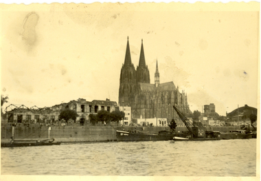
Photograph - black and white, Cologne Cathedral from the Rhine, c1950
... The twin spires were an easily recognizable navigational landmark for Allied aircraft bombing deeper into Germany, which may explain why the cathedral was spared. Repairs were completed in 1956. An emergency...The twin spires were an easily recognizable navigational landmark for Allied aircraft bombing deeper into Germany, which may explain why the cathedral was spared. Repairs were completed in 1956. An emergency ...Cologne Cathedral is a renowned monument of German Catholicism and Gothic architecture and is a World Heritage Site. It is Germany's most visited landmark, attracting an average of 20,000 people a day. (Wikipedia) Though not targeted itself, the cathedral was very near to the central railway station and suffered fourteen hits by aerial bombs during World War II. Badly damaged, it nevertheless remained standing in an otherwise completely flattened city. The twin spires were an easily recognizable navigational landmark for Allied aircraft bombing deeper into Germany, which may explain why the cathedral was spared. Repairs were completed in 1956. An emergency repair on the northwest tower's base carried out in 1944 using poor-quality brick taken from a nearby ruined building remained visible until 2005 as a reminder of the war, when it was decided to restore the section its original appearance. (Wikipedia) Black and white photograph showing a grand cathedral from a waterway. It is Cologne (Koln) Cathedral from the Rhine. To the left of the photo bombed buildings are evident. The photograph is believed to have been taken by Frank Wright.cologne cathedral, koln, germany, rhine, bombing, world war two, frank wright -
 Sunshine and District Historical Society Incorporated
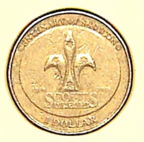
Coin - Australian One Dollar Coin - Centenary of Australia Scouting 2008
... navigation. - Survival Skills: Shelter building, fire lighting, and water purification. - Nature Conservation: Tree planting, wildlife monitoring, and clean-up projects. - First Aid: Emergency response and safety training. - Cooking: Campfire meals, bush cooking, and nutrition. - Crafts & DIY: Knot tying, woodwork, leatherwork, and badge-making. - STEM Projects: Robotics, coding, and environmental science. - Drama & Performance: Skits, storytelling, and talent shows. - Music & Dance: Campfire songs, cultural dances, and instrument practice. - Art & Design: Poster-making, painting, and costume creation. - Service Projects: Volunteering, fundraising, and helping local causes. - Leadership Training: Patrol leader roles, mentoring, and public speaking. - Cultural Exchange: International pen pals, travel, and global awareness. - Badge Work: Earning merit badges in areas like fitness, communication, and innovation. - Team Challenges: Problem-solving games and cooperative tasks. - Reflection & Journaling: Personal growth and goal setting. - Environmental Advocacy: Sustainability campaigns and eco-challenges....navigation. - Survival Skills: Shelter building, fire lighting, and water purification. - Nature Conservation: Tree planting, wildlife monitoring, and clean-up projects. - First Aid: Emergency response and safety training. - Cooking: Campfire meals, bush cooking, and nutrition. - Crafts & DIY: Knot tying, woodwork, leatherwork, and badge-making. - STEM Projects: Robotics, coding, and environmental science. - Drama & Performance: Skits, storytelling, and talent shows. - Music & Dance: Campfire songs, cultural dances, and instrument practice. - Art & Design: Poster-making, painting, and costume creation. - Service Projects: Volunteering, fundraising, and helping local causes. - Leadership Training: Patrol leader roles, mentoring, and public speaking. - Cultural Exchange: International pen pals, travel, and global awareness. - Badge Work: Earning merit badges in areas like fitness, communication, and innovation. - Team Challenges: Problem-solving games and cooperative tasks. - Reflection & Journaling: Personal growth and goal setting. - Environmental Advocacy: Sustainability campaigns and eco-challenges. ...Over the years, Australia has issued numerous commemorative $2 coins, often featuring vibrant colors and themes honoring national events, heroes, and cultural milestones. This coin was issued in 2008 to celebrate the centenary of Scouting in Australia. Sunshine Scouts & Cubs are part of the global youth movement that empowers young people to become responsible, active citizens through adventure, education, and service. It fosters character development, leadership, and community engagement across cultures and continents. Activities include: - Camping: From weekend bush camps to international jamborees. - Hiking & Orienteering: Map reading, compass skills, and trail navigation. - Survival Skills: Shelter building, fire lighting, and water purification. - Nature Conservation: Tree planting, wildlife monitoring, and clean-up projects. - First Aid: Emergency response and safety training. - Cooking: Campfire meals, bush cooking, and nutrition. - Crafts & DIY: Knot tying, woodwork, leatherwork, and badge-making. - STEM Projects: Robotics, coding, and environmental science. - Drama & Performance: Skits, storytelling, and talent shows. - Music & Dance: Campfire songs, cultural dances, and instrument practice. - Art & Design: Poster-making, painting, and costume creation. - Service Projects: Volunteering, fundraising, and helping local causes. - Leadership Training: Patrol leader roles, mentoring, and public speaking. - Cultural Exchange: International pen pals, travel, and global awareness. - Badge Work: Earning merit badges in areas like fitness, communication, and innovation. - Team Challenges: Problem-solving games and cooperative tasks. - Reflection & Journaling: Personal growth and goal setting. - Environmental Advocacy: Sustainability campaigns and eco-challenges.Australian One Dollar Coin. The obverse side features the portrait of Queen Elizabeth II. The reverse side features the international symbol for scouting, the fleur-de-lis representing the compass which symbolizes the three promises made by all scouts and cubs throughout the world.Obverse Side - Elizabeth II Australia 2008 Reverse Side - Centenary of Scoting 1908 - 2008 Scouts Australia One Dollarscouting, scouts -
 Moorabbin Air Museum
Accessory (Item) - Leather Satchel Marked With Associated Airlines - Melbourne
... Containing the following items, 1 Pr Sunglasses Ray-Ban Anti-Glare USA Style in case. 1 x Flight Plan for Associated Airlines dated 12.04.1960. 1 x Flight Plan TAA for VH-ASC, dated 11.05.57 1 x Flight Plan Associated Airlines dated 14.04.1960. 1 x Letter to airline and senior commercial pilots relating to routine ECG at medical examination from DCA dated 08.09.1959. 1 x Copy of Air Navigation Orders parts 20-95 as at 22.06.1959. 1 x copy of flight plan information for VH-ABH 1 x copy of notes on the radio beacon. 1 x copy of DCA Air Navigation Orders Part 20 Amendment List No.27 dated 07.07.1959. 1 x copy of DCA Emergency Procedure And Failure Of Radio Apparatus dated 29.09.59. 1 x copy of DCA New Route Structure - Sydney Area (Pilots Copy) Dated 16.12.1957. 1 x Measuring tape marked 26 o Lat to 38 o Lat....Containing the following items, 1 Pr Sunglasses Ray-Ban Anti-Glare USA Style in case. 1 x Flight Plan for Associated Airlines dated 12.04.1960. 1 x Flight Plan TAA for VH-ASC, dated 11.05.57 1 x Flight Plan Associated Airlines dated 14.04.1960. 1 x Letter to airline and senior commercial pilots relating to routine ECG at medical examination from DCA dated 08.09.1959. 1 x Copy of Air Navigation Orders parts 20-95 as at 22.06.1959. 1 x copy of flight plan information for VH-ABH 1 x copy of notes on the radio beacon. 1 x copy of DCA Air Navigation Orders Part 20 Amendment List No.27 dated 07.07.1959. 1 x copy of DCA Emergency Procedure And Failure Of Radio Apparatus dated 29.09.59. 1 x copy of DCA New Route Structure - Sydney Area (Pilots Copy) Dated 16.12.1957. 1 x Measuring tape marked 26 o Lat to 38 o Lat. ... -
 Moorabbin Air Museum
Book - Airbus A300 manuals, Airbus A300 Operating Manual
... Emergency equipment...Fire protection...Flight controls...Flight instruments...Fuel system...Hydrauilics...Ice & rain...Landing gear...Navigation...Moorabbin Air Museum Moorabbin Airport 12 First Street Moorabbin melbourne Airbus A300 manuals Air conditioning & pressurization Automatic flight Auxiliary power unit Communications Electrical Emergency equipment Fire protection Flight controls Flight instruments Fuel system Hydrauilics Ice & rain Landing gear Navigation systems Pneumatics Power plant Water & waste systems Warning systems Technical overview of all systems on Airbus A300, circa 1979 - 1982ic Airbus A300 Operating Manual Book Airbus A300 manuals ...Technical overview of all systems on Airbus A300, circa 1979 - 1982icnon-fictionTechnical overview of all systems on Airbus A300, circa 1979 - 1982icair conditioning & pressurization, automatic flight, auxiliary power unit, communications, electrical, emergency equipment, fire protection, flight controls, flight instruments, fuel system, hydrauilics, ice & rain, landing gear, navigation systems, pneumatics, power plant, water & waste systems, warning systems