Showing 269 items matching "eppalock"
-
 City of Greater Bendigo - Civic Collection
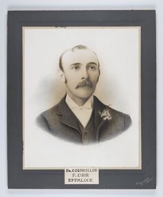
Photograph - Portrait of Councillor Orr, The Yeoman Studios, Ex. Councillor / F. Orr / Eppalock
... Councillor / F. Orr / Eppalock...The shire's administration centre was in Strathfieldsaye until 1972 when new offices were opened in Kennington. Eppalock Ward is one of three wards in the Greater Bendigo municipality which includes the former Strathfieldsaye Shire. ...Councillor / F. Orr / Eppalock / The / Yeoman / Studios...Councillor / F. Orr / Eppalock Photograph Portrait of Councillor Orr The Yeoman Studios ...The district of Strathfieldsaye was proclaimed in 1861 and named a Shire on the 17th September in 1866. It remained a shire until amalgamation in 1994 when it became part of the City of Greater Bendigo. The shire was located 8 km to the south- east of Bendigo and covered an area of 601 square kilometres and extended from the Calder Highway to the Coliban and Campaspe Rivers. The shire's administration centre was in Strathfieldsaye until 1972 when new offices were opened in Kennington. Eppalock Ward is one of three wards in the Greater Bendigo municipality which includes the former Strathfieldsaye Shire. Framed black and white head and shoulder portrait with hand coloured detail. Man with profile slightly to right, walrus moustache, image encircled. Photograph is attached to mount card. Hand written title lower centre.Ex. Councillor / F. Orr / Eppalock / The / Yeoman / Studiosshire of strathfieldsaye, councillor orr -
 Bendigo Historical Society Inc.
Map - EPPALOCK, 15/11/1928
... EPPALOCK......Eppalock...Map: Eppalock, County of Bendigo. Parish plan ( number 170 in Map Cupboard 1)...History House 11 Mackenzie Street Bendigo goldfields MAP Bendigo parish plan Eppalock Map: Eppalock, County of Bendigo. Parish plan ( number 170 in Map Cupboard 1) Map EPPALOCK ...Map: Eppalock, County of Bendigo. Parish plan ( number 170 in Map Cupboard 1)map, bendigo, parish plan, eppalock -
Bendigo Historical Society Inc.
Map - EPPALOCK, 3/07/1890
... EPPALOCK......Eppalock...Map: Parish of Eppalock. County of Bendigo. Parish plan (number 338 in map cupboard 1)...History House 11 Mackenzie Street Bendigo goldfields MAP Bendigo parish plan Eppalock Map: Parish of Eppalock. County of Bendigo. ...Map: Parish of Eppalock. County of Bendigo. Parish plan (number 338 in map cupboard 1)map, bendigo, parish plan, eppalock -
Bendigo Historical Society Inc.
Map - EPPALOCK, 3/11/1882
... EPPALOCK......Eppalock...Map: Parish of Eppalock, County of Bendigo. Parish plan (number 327 in map cupboard 1)...History House 11 Mackenzie Street Bendigo goldfields MAP Bendigo parish plan Eppalock Map: Parish of Eppalock, County of Bendigo. ...Map: Parish of Eppalock, County of Bendigo. Parish plan (number 327 in map cupboard 1)map, bendigo, parish plan, eppalock -
 Melbourne Legacy
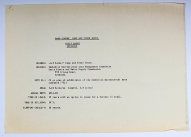
Plan - Document, plans, Lord Somers' Camp and Power House. Gully Lodge, Eppalock
... Lord Somers' Camp and Power House. Gully Lodge, Eppalock......eppalock...Lord Somers' Camp and Power House. Gully Lodge, Eppalock Plan Document, plans ...Plans for the permanent camp site used by Melbourne Legacy in the second half of the 20th century.Most of the Junior Legatees would have stayed at Lord Somers' camp, which is still in use.6 photocopied plans and 1 cover sheet - A4 size - black on white, single sided.camp, lord somers camp, power house, eppalock -
 Bendigo Military Museum
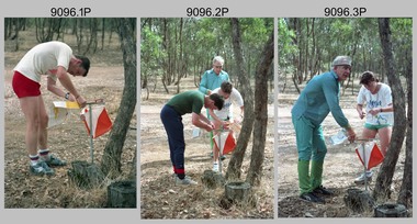
Photograph - Army Inter-area Orienteering Competition, Kimbolton State Forest, VIC, 1990
... This set of 29 photographs was taken during Army’s Inter-area Orienteering competition held in the Kimbolton State Forest, near Lake Eppalock, Victoria in 1990. Teams from Albury-Wodonga Bendigo, Broadmeadows, Melbourne Metropolitan, Puckapunyal and Watsonia participated in the annual competition. ...This set of 29 photographs was taken during Army’s Inter-area Orienteering competition held in Kimbolton State Forest, near Lake Eppalock, Victoria in 1990. The colour photographs are on 35mm negative film and were scanned at 2400 dpi. ......Lake Eppalock, VIC...Bendigo Military Museum 37 - 39 Pall Mall Bendigo goldfields This set of 29 photographs was taken during Army’s Inter-area Orienteering competition held in the Kimbolton State Forest, near Lake Eppalock, Victoria in 1990. Teams from Albury-Wodonga Bendigo, Broadmeadows, Melbourne Metropolitan, Puckapunyal and Watsonia participated in the annual competition. ...This set of 29 photographs was taken during Army’s Inter-area Orienteering competition held in the Kimbolton State Forest, near Lake Eppalock, Victoria in 1990. Teams from Albury-Wodonga Bendigo, Broadmeadows, Melbourne Metropolitan, Puckapunyal and Watsonia participated in the annual competition. Bendigo’s Army Survey Regiment led by SGT Mick Minchin hosted the Orienteering events. This set of 29 photographs was taken during Army’s Inter-area Orienteering competition held in Kimbolton State Forest, near Lake Eppalock, Victoria in 1990. The colour photographs are on 35mm negative film and were scanned at 2400 dpi. They are part of the Army Survey Regiment’s Collection. .1) to .4) - Photo, colour, 1990, unidentified competitors. .5) - Photo, colour, 1990, L to R: unidentified competitor, Bendigo’s Janet Murray. .6) - Photo, colour, 1990, L to R: unidentified official, Le-Anne (Smallshaw) Shirley, Bendigo’s Janet Murray, unidentified competitors (x2). .7) to .8) - Photo, colour, 1990, unidentified competitors. .9) - Photo, colour, 1990, L to R: unidentified official, Mick Minchin. .10) to .11) - Photo, colour, 1990, Mick Minchin. .12) to .13) - Photo, colour, 1990, Bendigo’s Team L to R: Rene van den Tol, Wolfgang Hofbauer, Mick Minchin, Harris Lee, unidentified competitor, Allan Blake, Janet Murray. .14) & .15) - Photo, colour, 1990, presentations L to R: Rene van den Tol, unidentified competitor. .16) to .19) - Photo, colour, 1990, unidentified competitors. .20) - Photo, colour, 1990, presentations L to R: Rene van den Tol, unidentified competitor. .21) - Photo, colour, 1990, presentations L to R: Rene van den Tol, unidentified competitor, Mick Minchin. .22) - Photo, colour, 1990, BBQ L to R: unidentified (x2), Jeff Rudd, Rene van den Tol, Mick Minchin, Neville Stone, Steve Cooper. .23) - Photo, colour, 1990, BBQ, Wolfgang Hofbauer. .24) - Photo, colour, 1990, BBQ, Janet Murray - in black jacket. .25) - Photo, colour, 1990, BBQ, all unidentified. .26) - Photo, colour, 1990, BBQ, Neville Stone - in green t-shirt, Rene van den Tol in red track suit, remainder unidentified. .27) - Photo, colour, 1990, BBQ L to R: unidentified (x4), Janet Murray, Le-Anne (Smallshaw) Shirley, remainder unidentified. .28) & .29) - Photo, colour, 1990, views of Lake Eppalock.There are no personnel identified. ‘Inter-Area Orienteering 1990’ annotated on negative sleevesroyal australian survey corps, rasvy, army survey regiment, army svy regt, fortuna -
 Bendigo Historical Society Inc.
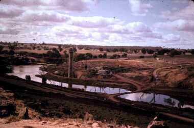
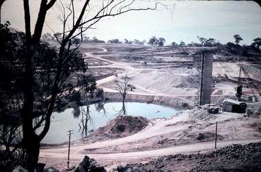
Slide - DAVID MCDONALD COLLECTION: EPPALOCK. CONSTRUCTION, 1960-1964
... ...Eppalock...Eppalock. Construction of Eppalock....History House 11 Mackenzie Street Bendigo goldfields CIVIL ENGINEERING Water supply Eppalock Kodak Ektachrome Eppalock. Construction of Eppalock. ...Eppalock. Construction of Eppalock.Kodak Ektachromecivil engineering, water supply, eppalock -
 Bendigo Historical Society Inc.
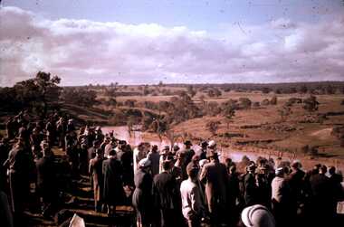
Slide - DAVID MCDONALD COLLECTION: EPPALOCK. CONSTRUCTION, c1960
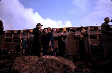
... ...Eppalock...Eppalock. Construction. People at the opening of Eppalock Scheme. ...History House 11 Mackenzie Street Bendigo goldfields CIVIL ENGINEERING Water supply Eppalock kodak Eppalock. Construction. People at the opening of Eppalock Scheme. ...Eppalock. Construction. People at the opening of Eppalock Scheme. Markings: Opening of Eppalock Scheme, 1960.kodakcivil engineering, water supply, eppalock -
 Bendigo Historical Society Inc.
Slide - DAVID MCDONALD COLLECTION: EPPALOCK. CONSTRUCTION, c1961
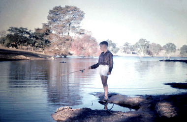
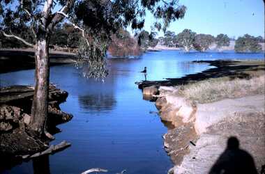
... ...Eppalock...Eppalock. Construction. Young boy fishing in Lake Eppalock. ...History House 11 Mackenzie Street Bendigo goldfields CIVIL ENGINEERING Water supply Eppalock Kodak Eppalock. Construction. Young boy fishing in Lake Eppalock. ...Eppalock. Construction. Young boy fishing in Lake Eppalock. Markings: Eppalock Dam 1961.Kodakcivil engineering, water supply, eppalock -
 Bendigo Historical Society Inc.
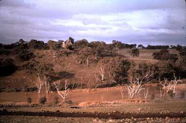
Slide - DAVID MCDONALD COLLECTION: EPPALOCK. CONSTRUCTION, c1960
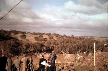
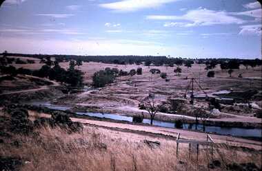
... ...Eppalock...Eppalock. Construction. Adults looking over the site of Lake Eppalock. ...History House 11 Mackenzie Street Bendigo goldfields CIVIL ENGINEERING Water supply Eppalock kodak Eppalock. Construction. Adults looking over the site of Lake Eppalock. ...Eppalock. Construction. Adults looking over the site of Lake Eppalock. Markings: Eppalock Dam Site 1960kodakcivil engineering, water supply, eppalock -
 Bendigo Historical Society Inc.
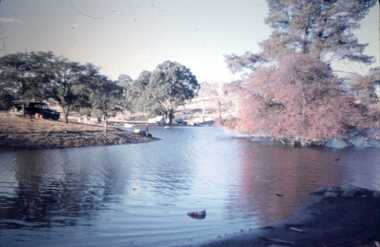
Slide - DAVID MCDONALD COLLECTION: EPPALOCK. CONSTRUCTION, c1963
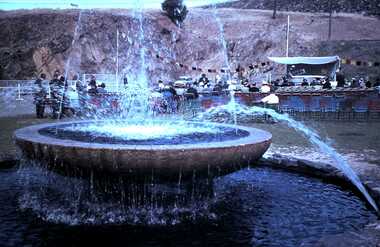
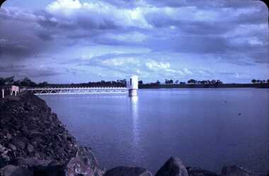
... ...Eppalock...Eppalock. Construction. The fountain at Eppalock Reservoir/Lake. 1963...History House 11 Mackenzie Street Bendigo goldfields CIVIL ENGINEERING Water supply Eppalock Agfacolor Eppalock. Construction. The fountain at Eppalock Reservoir/Lake. 1963 Slide DAVID MCDONALD COLLECTION: EPPALOCK. ...Eppalock. Construction. The fountain at Eppalock Reservoir/Lake. 1963Agfacolorcivil engineering, water supply, eppalock -
 Bendigo Historical Society Inc.
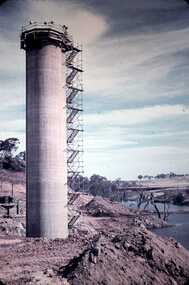
Slide - DAVID MCDONALD COLLECTION: EPPALOCK. CONSTRUCTION, c1960
... ...Eppalock...Eppalock. Construction. Water Tower built in Lake Eppalock....History House 11 Mackenzie Street Bendigo goldfields CIVIL ENGINEERING Water supply Eppalock Agfacolor Eppalock. Construction. Water Tower built in Lake Eppalock. ...Eppalock. Construction. Water Tower built in Lake Eppalock.Agfacolorcivil engineering, water supply, eppalock -
 Bendigo Historical Society Inc.
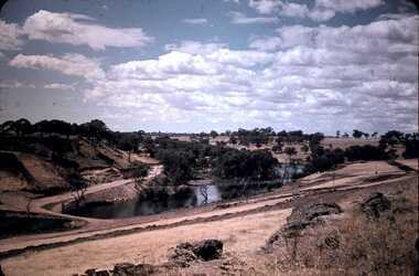
Slide - DAVID MCDONALD COLLECTION: EPPALOCK. CONSTRUCTION, c1960
... ...Eppalock...Eppalock. Construction. Markings: Eppalock Dam site 1960. ...History House 11 Mackenzie Street Bendigo goldfields CIVIL ENGINEERING Water supply Eppalock Eppalock. Construction. Markings: Eppalock Dam site 1960. ...Eppalock. Construction. Markings: Eppalock Dam site 1960. Shows water laying in the bottom of what will be Lake Eppalock.civil engineering, water supply, eppalock -
 Bendigo Historical Society Inc.
Slide - DAVID MCDONALD COLLECTION: EPPALOCK. CONSTRUCTION, c1961
... ...Eppalock...Eppalock. Construction. Shows the base of Eppalock with a small amount of water in it. ...History House 11 Mackenzie Street Bendigo goldfields CIVIL ENGINEERING Water supply Eppalock Agfacolor Eppalock. Construction. Shows the base of Eppalock with a small amount of water in it. ...Eppalock. Construction. Shows the base of Eppalock with a small amount of water in it. No equipment in sight. Markings: Eppalock Dam 1961.Agfacolorcivil engineering, water supply, eppalock -
 Bendigo Historical Society Inc.
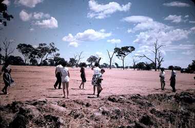
Slide - DAVID MCDONALD COLLECTION: EPPALOCK CONSTRUCTION, c1961
... ...Eppalock...Eppalock. Construction. Family group out looking at the construction of Lake Eppalock. ...History House 11 Mackenzie Street Bendigo goldfields CIVIL ENGINEERING Water supply Eppalock Agfacolor Eppalock. Construction. Family group out looking at the construction of Lake Eppalock. ...Eppalock. Construction. Family group out looking at the construction of Lake Eppalock. Markings: Near Eppalock Dam 1961.Agfacolorcivil engineering, water supply, eppalock -
 Bendigo Historical Society Inc.
Slide - DAVID MCDONALD COLLECTION: EPPALOCK. CONSTRUCTION, c1961
... ...Eppalock...Eppalock. Construction. Early stages of the construction of Lake Eppalock. ...History House 11 Mackenzie Street Bendigo goldfields CIVIL ENGINEERING Water supply Eppalock Agfacolor Eppalock. Construction. Early stages of the construction of Lake Eppalock. ...Eppalock. Construction. Early stages of the construction of Lake Eppalock. Markings: Campaspe Riv. & Eppalock Dam. Project. 1961Agfacolorcivil engineering, water supply, eppalock -
 Bendigo Historical Society Inc.
Slide - DAVID MCDONALD COLLECTION: EPPALOCK. CONSTRUCTION, c1963
... ...Eppalock...Eppalock. Construction. View of Lake Eppalock Tower full or near full of water. ...History House 11 Mackenzie Street Bendigo goldfields CIVIL ENGINEERING Water supply Eppalock Kodak Eppalock. Construction. View of Lake Eppalock Tower full or near full of water. ...Eppalock. Construction. View of Lake Eppalock Tower full or near full of water. Markings: Eppalock Tower Sept 1963.Kodakcivil engineering, water supply, eppalock -
 Bendigo Historical Society Inc.
Slide - DAVID MCDONALD COLLECTION: EPPALOCK. CONSTRUCTION, c1963
... ...Eppalock...Eppalock. Construction. David fishing of the bank at Lake Eppalock. ...History House 11 Mackenzie Street Bendigo goldfields CIVIL ENGINEERING Water supply Eppalock Kodak Eppalock. Construction. David fishing of the bank at Lake Eppalock. ...Eppalock. Construction. David fishing of the bank at Lake Eppalock. Markings: Eppalock Dam near Lyal March 1963 DavidKodakcivil engineering, water supply, eppalock -
 Bendigo Historical Society Inc.
Slide - DAVID MCDONALD COLLECTION: EPPALOCK. CONSTRUCTION, c1960
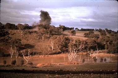
... ...Eppalock...Eppalock. Construction. The first charge going off on the rise in Lake Eppalock. ...History House 11 Mackenzie Street Bendigo goldfields CIVIL ENGINEERING Water supply Eppalock Kodak Eppalock. Construction. The first charge going off on the rise in Lake Eppalock. ...Eppalock. Construction. The first charge going off on the rise in Lake Eppalock. Markings; Exploding first charge, Eppalock 1960.Kodakcivil engineering, water supply, eppalock -
 Bendigo Historical Society Inc.
Slide - DAVID MCDONALD COLLECTION: EPPALOCK. CONSTRUCTION, c1960
... ...Eppalock...Eppalock. Construction. Viewing the opening . ...Markings: Eppalock Dam Site Slide DAVID MCDONALD COLLECTION: EPPALOCK. ...Eppalock. Construction. Viewing the opening . Markings: Eppalock Dam SiteKodakcivil engineering, water supply, eppalock -
 Bendigo Historical Society Inc.
Slide - DAVID MCDONALD COLLECTION: EPPALOCK. CONSTRUCTION, c1960
... ...Eppalock...Eppalock. Construction. Equipment being used to for the base of Lake Eppalock....History House 11 Mackenzie Street Bendigo goldfields CIVIL ENGINEERING Water supply Eppalock Agfacolor Eppalock. Construction. Equipment being used to for the base of Lake Eppalock. ...Eppalock. Construction. Equipment being used to for the base of Lake Eppalock.Agfacolorcivil engineering, water supply, eppalock -
 Bendigo Historical Society Inc.
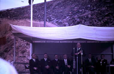
Slide - DAVID MCDONALD COLLECTION: EPPALOCK. CONSTRUCTION, c1963
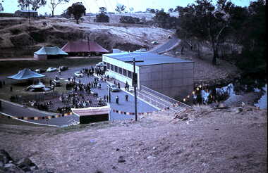
... ...Eppalock...Eppalock. Construction. Victorian Premier Sir Henry Bolte addresses the crowd at the opening of Lake Eppalock. 1963 opening of Eppalock Reservoir....History House 11 Mackenzie Street Bendigo goldfields CIVIL ENGINEERING Water supply Eppalock Agfacolor Eppalock. Construction. Victorian Premier Sir Henry Bolte addresses the crowd at the opening of Lake Eppalock. 1963 opening of Eppalock Reservoir. ...Eppalock. Construction. Victorian Premier Sir Henry Bolte addresses the crowd at the opening of Lake Eppalock. 1963 opening of Eppalock Reservoir.Agfacolorcivil engineering, water supply, eppalock -
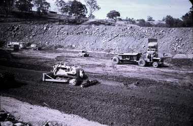
 Bendigo Historical Society Inc.
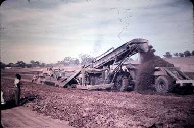
Slide - DAVID MCDONALD COLLECTION: EPPALOCK. CONSTRUCTION, c1960
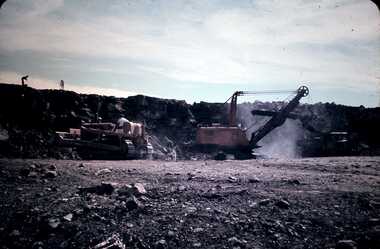
... ...Eppalock...Eppalock. Construction. Excavation equipment and trucks used in the formation of Lake Eppalock...History House 11 Mackenzie Street Bendigo goldfields CIVIL ENGINEERING Water supply Eppalock Agfacolor Eppalock. Construction. Excavation equipment and trucks used in the formation of Lake Eppalock Slide DAVID MCDONALD COLLECTION: EPPALOCK. ...Eppalock. Construction. Excavation equipment and trucks used in the formation of Lake EppalockAgfacolorcivil engineering, water supply, eppalock -
 Bendigo Historical Society Inc.
Slide - EPPALOCK. CONSTRUCTION, c1963
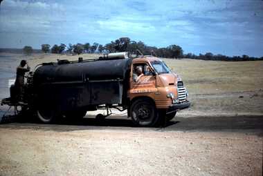
... ...Eppalock...Working at Lake Eppalock continues. Markings: Bitumen Heater - Spreader Eppalock, March 1963....Working at Lake Eppalock continues. Markings: Bitumen Heater - Spreader Eppalock, March 1963. ...Eppalock. Construction. There is already some water in the Lake. Working at Lake Eppalock continues. Markings: Bitumen Heater - Spreader Eppalock, March 1963.Kodakcivil engineering, water supply, eppalock -
 Bendigo Historical Society Inc.
Slide - DAVID MCDONALD COLLECTION: EPPALOCK. CONSTRUCTION, c1964
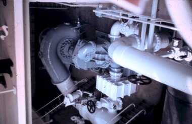
... ...Eppalock...Eppalock. Construction. Some of the pipes in the pump room at Eppalock....History House 11 Mackenzie Street Bendigo goldfields CIVIL ENGINEERING Water supply Eppalock Eppalock. Construction. Some of the pipes in the pump room at Eppalock. agfacolor Eppalock. ...Eppalock. Construction. Some of the pipes in the pump room at Eppalock.agfacolorcivil engineering, water supply, eppalock, eppalock. construction. some of the pipes in the pump room at eppalock. -
 Bendigo Historical Society Inc.
Slide - DAVID MCDONALD COLLECTION: EPPALOCK. CONSTRUCTION, c1960
... ...Eppalock...Eppalock. Construction. Earth moving equipment in use during the construction of Lake Eppalock....History House 11 Mackenzie Street Bendigo goldfields CIVIL ENGINEERING Water supply Eppalock Agfacolor Eppalock. Construction. Earth moving equipment in use during the construction of Lake Eppalock. ...Eppalock. Construction. Earth moving equipment in use during the construction of Lake Eppalock.Agfacolorcivil engineering, water supply, eppalock -
 Bendigo Historical Society Inc.
Slide - DAVID MCDONALD COLLECTION: EPPALOCK. CONSTRUCTION, c1963
... ...Eppalock...Eppalock. Construction. 1963 opening of Eppalock Reservoir. ...History House 11 Mackenzie Street Bendigo goldfields CIVIL ENGINEERING Water supply Eppalock Agfacolor Eppalock. Construction. 1963 opening of Eppalock Reservoir. ...Eppalock. Construction. 1963 opening of Eppalock Reservoir. Pump house to right of picture.Agfacolorcivil engineering, water supply, eppalock -
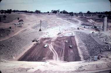
 Bendigo Historical Society Inc.
Slide - DAVID MCDONALD COLLECTION: EPPALOCK. CONSTRUCTION, c1960
... ...Eppalock...Eppalock. Construction. Slide shows the construction of Lake Eppalock in its early stages....History House 11 Mackenzie Street Bendigo goldfields CIVIL ENGINEERING Water supply Eppalock Agfacolor Eppalock. Construction. Slide shows the construction of Lake Eppalock in its early stages. ...Eppalock. Construction. Slide shows the construction of Lake Eppalock in its early stages.Agfacolorcivil engineering, water supply, eppalock -
 Bendigo Historical Society Inc.
Slide - DAVID MCDONALD COLLECTION: EPPALOCK. CONSTRUCTION, c1963
... ...Eppalock...Eppalock. Construction. Lake Eppalock appears to already have become a popular spot for camping and fishing. ...History House 11 Mackenzie Street Bendigo goldfields CIVIL ENGINEERING Water supply Eppalock Kodak Eppalock. Construction. Lake Eppalock appears to already have become a popular spot for camping and fishing. ...Eppalock. Construction. Lake Eppalock appears to already have become a popular spot for camping and fishing. Markings: Eppalock Dam near Lyal, March 1963.Kodakcivil engineering, water supply, eppalock -
 Bendigo Historical Society Inc.
Slide - DAVID MCDONALD COLLECTION: EPPALOCK. CONSTRUCTION, c1960
... ...Eppalock...Eppalock. Construction. Machinery excavating what was farming area to make way for Lake Eppalock....History House 11 Mackenzie Street Bendigo goldfields CIVIL ENGINEERING Water supply Eppalock Agfacolor Eppalock. Construction. Machinery excavating what was farming area to make way for Lake Eppalock. ...Eppalock. Construction. Machinery excavating what was farming area to make way for Lake Eppalock.Agfacolorcivil engineering, water supply, eppalock