Showing 53 items matching eucalyptus gum tree
-
 Eltham District Historical Society Inc
Photograph, Liz Pidgeon, Heritage Excursion; East of Eltham, 6 Sep 2014, 20 May 2017
Newsletter No. 218, September 2014 September Excursion - East of Eltham Walk In Newsletter No. 197, March 2011, there was a brief history of Crown Allotment 15 Section 5 Parish of Nillumbik (CA 15) a parcel of land of a quarter of a square mile extending from Eucalyptus Road to Reynolds Road at the eastern extremity of Eltham. From the 1940s it was known as Stokes orchard. In later years it has been subdivided for residential purposes but leaving significant areas as power line and water supply reserves and bushland reserves that are habitat for the threatened For our excursion on 6th September we intend to walk through CA 15 to a bushland reserve east of Reynolds Road. The walk will traverse the boundary between suburban Eltham and the non-urban areas to the south and east. This is a pleasant walk through residential areas and bushland. Along the way we will discuss the early and more recent history of CA 15 as well as local natural history and geology. This walk is about 3.5 km in length and will take 2 to 2.5 hours. It will start at 2pm at the corner of Eucalyptus Road, Pitt Street and Nyora Road.Born Digitaleltham east, eltham district historical society, heritage excursion, activities, nyora road, reynolds road, gum tree road reserve, diosma road, stokes orchard, eucalyptus road -
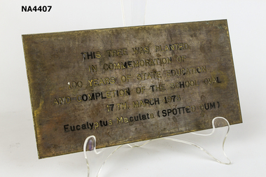 Whitehorse Historical Society Inc.
Plaque - Commemorative Plaque, 1970s
Brass commemorative plaque. This Tree was planted in commemoration of 100 years of State Education and completion of the school oval 17th March 1973. Eucalyptus Maculata (Spotted Gum)As aboveschool, equipment -
 Eltham District Historical Society Inc
Photograph, Fay Bridge, Ancient Eel trap on the Yarra River at Laughing Waters, Eltham - pre-dating European settlement, 6 September 2023
Laughing Waters is the name for a stretch of the Yarra Valley Parklands consisting of river flats and hilly riparian bushland. With Birrarung (Yarra River) flowing through, Laughing Waters has been an important gathering place for thousands of years. For the Wurundjeri, ‘Garambi Baan’ (the name for Laughing Waters in Woi wurrung) is an important site for growing and harvesting food. Significantly, Wurundjeri iuk (eel) traps remain at Garambi Baan to this day. The Wurundjeri Woi Wurrung People take their name from the Woi wurrung language word ‘wurun’ meaning the Manna Gum (Eucalyptus viminalis) which is common along ‘Birrarung’ (Yarra River), and ‘djeri’, the grub which is found in or near the tree. Wurundjeri are the ‘Manna Gum People’ and their Ancestors have lived on this land for millennia. The site on the Yarra River near the former Morrison property Killeavey was given a language name in 2015 at the instigation of Wurundjeri Elder, Dave Wandin. Garambi Baan means “laughing waters” in the traditional language, Woi wurrung. The site at Warrandyte was rediscovered by Campbell Beardsell OAM in 2007 and is one of only a few known remaining iuk (eel) traps on Country once found the length of the Birrarung (Yarra) and the Maribyrnong. Original Indigenous aquacultural infrastructure was dismantled, taken away from sites and used to build houses, fords and roads by Europeans. The difficult and restricted access to this site is thought to be one of the reasons for its survival. The iuk trap is located within lands managed by Parks Victoria. The Narrap team in partnership with Parks Victoria and Acacia Land Management have been improving the native vegetation with a program of woody weed removal, exclusion fencing and revegetation. Importantly, the team have restored the trap’s infrastructure and have demonstrated its effectiveness.” References: Wurundjeri Woi Wurrung Cultural Heritage Aboriginal Corporation - Laughing Waters. (2023, September 3). Retrieved from https://inplace.org.au/laughing-waters/ GARAMBI BAAN LAUGHING WATERS RESIDENCY CENTRE 2020 2024 Strategic Plan, Nillumbik Shire Council (2023, September 3). Retrieved from https://www.nillumbik.vic.gov.au/files/assets/public/minutes-and-agendas/2020/09-sep/15-sep-cm/ocm.177-20-attachment-1-laughing-waters-arts-program_1.pdffay bridge collection, eel trap, laughing waters, yarra river, wurundjeri woi wurrung, garambi baan, 2023-09-06 -
 Eltham District Historical Society Inc
Photograph, Fay Bridge, Ancient Eel trap on the Yarra River at Laughing Waters, Eltham - pre-dating European settlement, 16 May 2015
Laughing Waters is the name for a stretch of the Yarra Valley Parklands consisting of river flats and hilly riparian bushland. With Birrarung (Yarra River) flowing through, Laughing Waters has been an important gathering place for thousands of years. For the Wurundjeri, ‘Garambi Baan’ (the name for Laughing Waters in Woi wurrung) is an important site for growing and harvesting food. Significantly, Wurundjeri iuk (eel) traps remain at Garambi Baan to this day. The Wurundjeri Woi Wurrung People take their name from the Woi wurrung language word ‘wurun’ meaning the Manna Gum (Eucalyptus viminalis) which is common along ‘Birrarung’ (Yarra River), and ‘djeri’, the grub which is found in or near the tree. Wurundjeri are the ‘Manna Gum People’ and their Ancestors have lived on this land for millennia. The site on the Yarra River near the former Morrison property Killeavey was given a language name in 2015 at the instigation of Wurundjeri Elder, Dave Wandin. Garambi Baan means “laughing waters” in the traditional language, Woi wurrung. The site at Warrandyte was rediscovered by Campbell Beardsell OAM in 2007 and is one of only a few known remaining iuk (eel) traps on Country once found the length of the Birrarung (Yarra) and the Maribyrnong. Original Indigenous aquacultural infrastructure was dismantled, taken away from sites and used to build houses, fords and roads by Europeans. The difficult and restricted access to this site is thought to be one of the reasons for its survival. The iuk trap is located within lands managed by Parks Victoria. The Narrap team in partnership with Parks Victoria and Acacia Land Management have been improving the native vegetation with a program of woody weed removal, exclusion fencing and revegetation. Importantly, the team have restored the trap’s infrastructure and have demonstrated its effectiveness.” References: Wurundjeri Woi Wurrung Cultural Heritage Aboriginal Corporation - Laughing Waters. (2023, September 3). Retrieved from https://inplace.org.au/laughing-waters/ GARAMBI BAAN LAUGHING WATERS RESIDENCY CENTRE 2020 2024 Strategic Plan, Nillumbik Shire Council (2023, September 3). Retrieved from https://www.nillumbik.vic.gov.au/files/assets/public/minutes-and-agendas/2020/09-sep/15-sep-cm/ocm.177-20-attachment-1-laughing-waters-arts-program_1.pdffay bridge collection, 2015-05-16, eel trap, laughing waters, yarra river, wurundjeri woi wurrung, garambi baan -
 Eltham District Historical Society Inc
Photograph, Fay Bridge, Yellow Box Gum tree near junction of Main Yarra Trail and Mullum-Mullum Trail, Templestowe, 7 July 2019
... Box Gum (Eucalyptus Melliodora) 1 image - born digital Yellow ...Situated in the wetlands on the trail opposite the Pontville Homestead, former home of Major Charles Newman and across the Yarra River from Sweeneys Flats, Eltham. Newman also purchased Allotment 5, Section 2 (in Ely Street, Eltham) at public autction on 17 September 1851. It was the only Section 2 allotment purchased at the firts Elthan Town Allotments public auction.fay bridge collection, sweeneys flats, 2019-07-07, major charles newman, mullum mullum creek, pontville homestead, significant tree, yellow box gum (eucalyptus melliodora) -
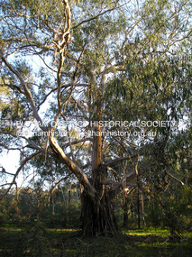
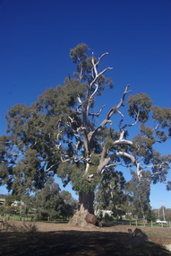 Ballarat Heritage Services
Photograph - Photograph - Colour, Clare Gervasoni, Big Tree, Guildford, Victoria, 2017, 16/07/2017
... - a River Red Gum (Eucalyptus camaldulensis). The tres is believed... of Guildford's Big Tree - a River Red Gum (Eucalyptus camaldulensis ...The Big Tree is listed a a tree of State significance on the National Trust's Register of Significant Trees of Victoria for its outstanding size, curious fusion of branches, as an outstanding example of the species and as an important landmark.A number of colour photographs of Guildford's Big Tree - a River Red Gum (Eucalyptus camaldulensis). The tres is believed to be one of the largest examples of the species in Victoria, and has been recorded as having a height of 30 metre, a canopy spread of 34 metres, and a trunk circumference of 9.35 metres. The tree was already an ancient giant when white settlers first arrived in the 1840s. On Saturday evening, February 28th 2015, just as dusk was falling, Guildford was hit hard by tornado-like winds, felling the big cottonwood tree down by the river, and tearing limbs from the iconic Big Tree, reducing it by an estimated one third. The debris has been cleared since then and the tree seems to have survived its ordeal, though its size is certainly diminished.big tree, guidlford, river red gum -
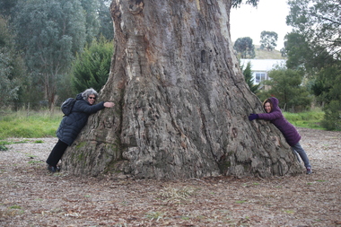 Ballarat Heritage Services
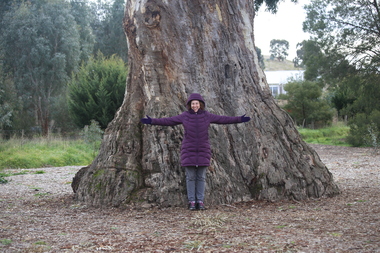
Photograph - Photograph - Colour, Clare Gervasoni, Clare Gervasoni and Ann Gervasoni at the Guildford Big Tree, 2017, 16/07/2017
... A photographs of Guildford's Big Tree - a River Red Gum... guidlford river red gum A photographs of Guildford's Big Tree ...The Big Tree is listed a a tree of State significance on the National Trust's Register of Significant Trees of Victoria for its outstanding size, curious fusion of branches, as an outstanding example of the species and as an important landmark.A photographs of Guildford's Big Tree - a River Red Gum (Eucalyptus camaldulensis). The tre-es is believed to be one of the largest examples of the species in Victoria, and has been recorded as having a height of 30 metre, a canopy spread of 34 metres, and a trunk circumference of 9.35 metres. The tree was already an ancient giant when white settlers first arrived in the 1840s. On Saturday evening, February 28th 2015, just as dusk was falling, Guildford was hit hard by tornado-like winds, felling the big cottonwood tree down by the river, and tearing limbs from the iconic Big Tree, reducing it by an estimated one third. The debris has been cleared since then and the tree seems to have survived its ordeal, though its size is certainly diminished.big tree, guidlford, river red gum -
 Ballarat Heritage Services
Photograph - Photograph - Colour, Clare Gervasoni, Ann Gervasoni at the Guildford Big Tree, 2017, 16/07/2017
... A photographs of Guildford's Big Tree - a River Red Gum... guidlford river red gum A photographs of Guildford's Big Tree ...The Big Tree is listed a a tree of State significance on the National Trust's Register of Significant Trees of Victoria for its outstanding size, curious fusion of branches, as an outstanding example of the species and as an important landmark.A photographs of Guildford's Big Tree - a River Red Gum (Eucalyptus camaldulensis). The tre-es is believed to be one of the largest examples of the species in Victoria, and has been recorded as having a height of 30 metre, a canopy spread of 34 metres, and a trunk circumference of 9.35 metres. The tree was already an ancient giant when white settlers first arrived in the 1840s. On Saturday evening, February 28th 2015, just as dusk was falling, Guildford was hit hard by tornado-like winds, felling the big cottonwood tree down by the river, and tearing limbs from the iconic Big Tree, reducing it by an estimated one third. The debris has been cleared since then and the tree seems to have survived its ordeal, though its size is certainly diminished.big tree, guidlford, river red gum -
 University of Melbourne, Burnley Campus Archives
Photograph - Black and white print, Plant Research Institute, 1932
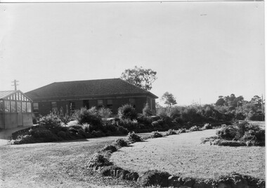
Note by T.H. Kneen 19 November 1991, "The two trees beyond the P.R.L. Are Eucalyptus camaldulensis(Red Gum) and the nearer and taller of the two was severely damaged by a storm (mid fifties). The other tree has survived and is a very good specimen."Black and white photograph. View of rear of Plant Research Institute/Laboratory (PRI/PRL), glasshouse and circular bed.On reverse, "Plant Research Laboratory, Glasshouse & Back Entrance to P.R.L. Dec 1932," signed by A.W. Jessep.plant research laboratory, prl, glasshouse, a.w. jessep, plant research institute, pri, trees, eucalyptus camaldulensis, department of agriculture victoria